The fifth annual PCS climborama took place in the Kearsarge Pass area during the first week of August. The main organizer of this year's trip, Bob Suzuki, was unable to go because of a foot injury, so Steve Eckert took over as leader and the party included Tim Hult, Aaron Schuman, Charles Schafer, Joe Budman, Linda Roman, Richard Carey, and your scribe Jim Ramaker.
Steve, Joe, and I spent a pleasant night at Deadman Summit on Highway 395 and then met Linda and Richard at the Onion Valley trailhead. (By the way, the name of the side road at Deadman Summit has been changed from "Glass Flow Road" to "Obsidian Dome Road.") The five of us hiked over Kearsarge Pass and down to Bubbs Creek, camping in the forest at a bear box across from East Vidette Peak (12,350), our first objective. On the hike in, Joe split off and bagged the first peak of the trip, Mt. Gould (13,005). After supper, Tim Hult strolled into camp, having left the trailhead later in the morning. The evening was very warm for being over 10,000 feet, and the bugs were moderately bad.
Sunday, we tackled the east ridge of East Vidette, gaining the crest of the ridge by circling around to the left (south) of a huge dome-like gendarme and then climbing a short airy class-3 section. After that we had a very pleasant hour of class 2-3 ridge running, and the top was ours by 10:30, three hours after leaving camp. We descended by a more direct route down a scree gully on the north side of the east ridge. Footing in the gully was unpleasant, with loose scree on top of slabs and bedrock.
After a rest in camp, we cached the bulk of our food in the bear box and hiked cross-country to the west to circle around to Vidette Lakes. We found a gorgeous camp at the lake closest to East Vidette Peak, and for the second day in a row, we had plenty of time to relax in camp in the evening. This was a welcome contrast to past climboramas, when we were often on the go until 7 or 8 p.m. Tim even had time to set up his fishing rod and catch four nice trout, which he then cooked and shared with those of us not yet asleep. Around this time, Aaron and Charles appeared, having hiked in a day after the rest of us. So our group of eight was finally complete, just in time for Monday's attempt on Deerhorn (13,265), our first really interesting peak.
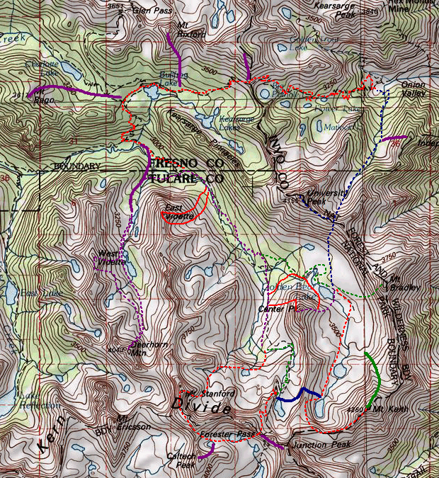
We got up at 5:30 am and at 7 started hiking up the beautiful alpine valley leading up to Deerhorn. Deerhorn is a twin peak, with northwest and southeast peaks separated by a steep snow couloir. The route goes up a buttress on the northwest peak, then crosses over a saddle to the slightly higher southeast peak. It's surprisingly easy if you go just the right way, but steep rock abounds if you get even slightly off route.
By 10 we were picking our way up a steep, loose, scree slope to gain the buttress. This was the hardest part of the climb, particularly with our large group, as we were continually sending down missiles and getting in each others' fall lines. The best way to climb this section, which Richard Carey discovered on the descent, is to start about 500 yards right of the toe of the buttress and traverse gradually up and left, aiming for a weakness in the cliffs with dark rock about 100 yards right of the toe. This route has the added advantage for a group of keeping people spread out horizontally.
Once we gained the buttress, the climbing got much better -- moderate class-3 on solid slabs and boulders. We continued up the buttress for 1000 feet or so until we were actually above the saddle, then traversed left over to it. From the sandy saddle, we circled around the summit tower to the right, cut back to the left across a second, higher saddle, and the circled back to the right up to the summit. From the first saddle, the route forms an "S" shaped pathway of class 2-3 climbing. Deviate from this route and you'll find big air. We summited at noon and relaxed in the warm, windless day -- at over 13,000 feet, it was actually too warm. Smoke from the fire at the southern end of the Sierras obscured the distant views, but we could still see plenty of inviting peaks.
The descent went smoothly, and by 2 we were relaxing in a small patch of grass in the boulder field below the peak. Aaron, Joe, Tim, and I then split off to climb West Vidette (12,560), a mundane scree slog with little to recommend it except an exposed, foot-wide summit ridge at the very top. (If you prefer, you can easily avoid this ridge and stay on scree.) This second peak made for a long day, with the summit at 5:30 and camp at 7:30. We'd seen quite a few clouds during the day, and that night we had a light rain shower right at midnight, confirming that the weather was a bit weird.
Tuesday morning we all retraced our steps back to the bear box on Bubbs Creek, where we discovered our food had been attacked not by bears but by human thieves. Fortunately they only skimmed off a few goodies such as energy bars and Steve's gourmet Costco muffins, and didn't take enough to affect our plans. Aggravating nevertheless.
At this point we split up again -- Aaron and Charles to climb East Vidette, Tim and Linda to head up the Muir Trail and find a campsite for us all, and Steve, Richard, Joe, and I to tackle the west face of Center Peak (12,760). This was in keeping with Steve's new post-list-finish philosophy of climbing familiar peaks by new routes.
Access to the west face is barred by a 200' high, mile-long cliff across the bottom of the face. The guidebook says to take a chute 100 yards right of the left edge of the face, but no such chute exists. After some debate, we headed for an apparent chute at least 500 yards from the left edge. This chute is almost invisible from the north on the Muir Trail, but very obvious from the south, and has a dark indentation on its right side. We climbed up the sandy chute, passing a class-3 section a few hundred feet up and gaining access to the huge scree terrace on the left side of the west face.
From here we traversed up and right toward the steep slabs and ribs on the right side of the west face. I kept wanting to climb to the skyline and get our bearings, even though I suspected there was nothing up there but a jagged ridge with big air on the other side. But Steve insisted that we keep traversing, and his routefinding was the key to the climb.
The guidebook says to climb up and right, pass through a tunnel, and climb class-3 slabs to the summit. We traversed across a rib and thought we might be stumped when we saw only steep rock beyond, but then Joe casually mentioned that he'd seen a tunnel a few yards back. The tunnel was a vertical elevator shaft with a 10-ton, car-sized block poised precariously over the top of it. Watermelon-sized blocks in the elevator shaft supplied the holds and appeared to hold up the 10-ton block, and most of them were loose. We climbed carefully up this threatening mess, and popped out of a hole at the top to gaze across a smooth class-4 slab. The slab was inclined at 50 degrees above a death fall, but it did have a nice 2" crack into which you could insert your boot tips, plus a hairline crack above it for your fingertips. Led by Joe, all four of us soon crept across it, with a promise from Steve that we didn't have to come back this way because there was an easy descent on the east slope. We had a lightweight rope, but no one asked for a belay. As on the day before, dark clouds were building to the south, but we heard no thunder.
After the ledge, fun class-3 climbing led to the top, which has a leaning summit pinnacle somewhat like Bear Creek Spire. After a short rest, we quickly descended the sand and scree on the east slope and came down into Center Basin, one of the prettiest alpine valleys in the Sierras. A cross-country trek past a couple of lakes and through the timberline forest north of Center Peak brought us back to our packs by 5:30 and to our camp further south on the Muir trail about 6:30. Linda and Tim had found an impressive improved camp next to a creek at a bend in the Muir Trail, with even a massive homemade "bear box" constructed of logs and rocks. Charles and Aaron failed to show up in camp that evening, but we just figured they'd taken longer than expected to do East Vidette, which was indeed the case. (By the way, they also had a few goodies stolen out of the bear box the day after we did.)
Wednesday was the day for Stanford (13,963), the peak that everyone on the trip really wanted because it's a "deep peak" (far from the trailhead) with no easy routes. We woke at 5:30 and were rolling just after 6:30 on a cloudless Sierra morning. With four days of acclimatization and a strong, experienced party, what could stop us? We climbed up some beautiful slabs past a lake to a plateau at about 12,000' and then noticed an amazing site -- a huge, thick bank of clouds rolling in rapidly from the southeast. Eight hours ahead of schedule and coming from the opposite direction from typical Sierra thunderstorms, this was not a good sign. Clearly, we were in the path of one of those dreaded "tropical systems" that can bring bad weather to the Sierras for days. We retreated to camp, where a downpour between 8:30 and 10 a.m. kept us tentbound. Well, there are worse things than an early morning walk followed by a deep nap nestled in warm down with rain beating on the tent.....
Around 10 we looked out of the tents and saw blue sky and bright sun, which on Wall Street is known as a "sucker rally." Linda, Tim, Joe, and I decided to hike up to Forester Pass (13,200), and if the weather continued improving, try for Junction Peak (13,888). When we got to the pass, the weather was deteriorating again and we could see waves of clouds and rain blowing in from the south, with a few far-off booms of thunder. We huddled under overhangs to wait out the rain, conversing with the Muir Trail hikers trooping over the pass. As had been the case all week, the air was unusually warm and winds were light, which made the storm basically quite mild. This was good luck indeed for some of the hikers -- we saw some Boy Scouts from Ridgecrest dressed in nothing more than blue jeans, cotton t-shirts, and plastic laundry bags with a hole cut in the top for raingear.
Around 1 Tim and Linda bailed out, but Joe and I sat around, enjoying the scenery and waiting out the weather. At last around 2:30, we took advantage of a partial clearing to at least check out the route over to Junction Peak. We quickly reached the sandy saddle between Ski Mountaineer's Peak and Junction, then climbed up about 50' and traversed into a wide scree gully. 50' up the gully we found a wide ledge that took us across a steep rib and into a second wide scree gully. Marking our crossing point, we climbed this gully for about 300' almost to the skyline, and found a second hidden ledge system that took us across another steep rib and into a third wide gully. Wandering up the left side of this gully on steep class-3 slabs brought us to the summit at 4 p.m. By intuition and luck, we'd found a great route to the top that avoided lots of hard climbing both above and below it. The sky was ominously dark with occasional light drizzle, but no thunder and no wind.
After some hero photos, we retraced our route to Forester Pass and hiked happily down the Muir Trail to camp, where we arrived at 7 p.m. Aaron and Charles had shown up, while Tim and Linda had left the trip and headed for the cars. With renewed enthusiasm, the six of us remaining planned a rematch with Stanford on Thursday. But the weather mocked these plans -- at 4 a.m., an hour before our wake-up time, a spectacular lightning display woke us up, the huge flashes coming every 20 seconds or so and lighting up the entire basin we were camped in for a surreal instant. Aaron got us up at 5:30 as the storm eased off, and a lengthy discussion ensued about what to do. We still had four days and a number of peaks left on our itinerary, but Steve and others felt the bad weather was going to hang on for days, so he decided to disband the trip and head home.
Steve, Aaron, and Charles headed for Kearsarge Pass and the cars; Richard set off solo for Mt. Bradley and University Pass; and Joe and I decided to head back to Center Basin and see if we could sneak up some more peaks between storms. After retracing our steps from Tuesday afternoon, we set up our tent at a wonderful spot above Golden Bear Lake. At 10 am, with clouds moving in, we set off up the valley toward Mt. Keith (13,977), the highest but also about the easiest peak on our itinerary. We climbed a rockslide of car-sized blocks up into the talus bowl northeast of the peak, then climbed up to 13,000' and huddled under an overhanging rock as the storm closed in and light rain and hail came down. When lightning started, we moved out onto the talus slope, since an overhang or cave on a mountainside is one of the worst possible places to be in a lightning storm.
For almost three hours, we sat and talked, watching a hard-edged thundercloud move over our heads and billow up into a gigantic mushroom cloud. After that came another bigger and darker thundercloud. Interestingly, most of the rain and lightning was at the trailing edge of these thunderclouds as they moved over us from the south. Around 3:30, with still no break in the occasional thunder, we gave up and decided to at least stroll over to the Sierra Crest and look down into Owens Valley before descending. Just then the lightning picked up its tempo to a strike every 20 seconds or so, sometimes smashing into the peaks just above us. Walking over to the crest suddenly didn't seem like a good idea, and we hurried down into the talus bowl, involuntarily ducking our heads when the lightning flashed, and 3-4 seconds later, the thunder cracked and boomed. We got hailed on pretty good for awhile, and then the rain let up as we walked backed down Center Basin to camp and got inside our tent. Then at 5:30 the sky cut loose in a drenching downpour, the heaviest we'd seen yet. Once again I drifted off into a blissful rain sleep, hoping our tent would stay dry in this downpour that felt like it would go on all night.
But then at 7 came a sudden unfamiliar silence, and we poked our heads out of the tent to see an amazing sight -- a clear sky with just a few shreds of clouds scudding away, and on the nearby peaks of Center, Keith, Bradley, and University, every rock and pebble standing out distinctly in clear golden light. Even better, for the first time all week, the air felt like real mountain air -- cold and fresh. Could it be that the wet, tropical system dogging us all week had finally lost out to a mass of cold mountain air? We went to sleep under sharp stars, hoping for the best.
Friday dawned cloudless, and about 15 degrees colder than previous mornings. We retraced our steps up Mt. Keith, and finally found the best way through the rockslide of car-sized blocks. Going up from Center Basin to the talus bowl northeast of Mt. Keith are three wide tiers of cliffs -- the bottom two dark and water stained, and the upper one light grey. If you climb past the left edge of the first two cliff bands, a hidden scree ledge leads right, under the third cliff band, and from there you can follow the watercourse up, saving much strenuous climbing up big blocks.
We climbed past Thursday's high point at 9:30, then finally strolled across the sandy rock garden below the summit and up to the top at 10:30. Among the register entries was none other than Sir Edmund Hillary, from the mid-1980s. Views of nearby Williamson, Tyndall, and Junction were spectacular in the newly clear air. After a long rest and snack break, we descended back to Center Basin.
Instead of a short break in camp, my 23-year-old go-getter partner Joe suggested we head directly for Mt. Bradley (13,289), so around 1:30 we started up another tedious 1000' scree gully. From the top of the gully, the 50' high summit tower appears to be class 4/5 from all sides, but it has an amazing, 45-degree, 12" wide sand ramp hidden around the back. The register was an especially good one, extending from 1958 to the previous day, when Richard had left a greeting for Joe and me. We slid and surfed our way down the scree gully and arrived back at our tent at 4:30, for a three-hour round trip. It was great to have a few hours free in the evening again -- Joe rested in the tent reading his hardcover novel and gazing at the scenery, while I explored the nearby creeks and the lakeshore, observing the rocks, flowers, mosses, and darting trout. That night was our first cold, dry, bug-free night of the trip, so I celebrated by sleeping out under the Milky Way.
Saturday it was up and over University Pass (12,700). The route to the pass goes up a long narrow scree gully that heads for the second low spot south of University Peak (13,632). At 2/3 height, it pinches down and is blocked by a chockstone, which we passed via a strenuous class-3 move (me) or class-2 slabs off to the right (Joe). We got to the pass at 9:30, dropped our packs, and headed left to University Peak with just water bottles in our pockets and jackets around our waists. The key to this route is to climb about 30' feet from the pass, then traverse for about 1/4 mile without gaining any more altitude until you can see the summit mass, which is marked by a bunch of thin slabs sandwiched together vertically near the top. (Gaining altitude sooner will take you up and down several false summits.) Most of this traverse is class-1 sand, with some easy class-3 going up to the summit, so it's a mystery why University is an SPS Mountaineer's Peak.
We topped out at 10:30 and talked to a solo climber with one of those alpine dogs that could climb anything up to moderate class-3 without whimpering. After a break, Joe and I quickly traversed back to the pass and plunged down the steep slope to the east. This basin has some of the most savage cross-country terrain I've seen in the Sierras -- not talus or scree, but pure moraine -- everything from sand and mud to car-sized blocks, jumbled together on a steep, loose slope that looks like the aftermath of a thermonuclear bomb.
Going out, with a light pack and a week of acclimatization, it offers a doable alternative to the Kearsarge Pass trail. Not counting the side trip to University Peak, we went from Center Basin to Onion Valley in 4 hours, compared to 9 hours or so to go out on the trail. But going in, with a full pack and no acclimatization, I'd take the trail -- going up that steep loose crap with a heavy pack is not my idea of noble suffering. Of course, thick, firm snow that covered up the moraine could change the equation completely.
Eventually, we got down out of the moraine and cross-countried down into the forest, picking up the trail at the outlet of Robinson Lake. We reached the car at 3, washed up, and headed for the Bishop Sizzler, as the last flame of the climborama flickered out for another year.
Steve Eckert adds:
This year Bob wanted to shift the annual peak-bagging "Climb-O-Rama" into August since the mosquitoes were so terrible last 4th of July... but it turns out the bugs weren't bad this July and we got nailed by monsoon rains.
Our entire trip was rather ambitious, optional and actual routes are traced
on this map from TOPO!
Remember that we didn't do many of the peaks as a group (although a few people
got way more than I did by huddling while squalls passed over and continuing to climb).
We climbed Center Peak from the west side, since I had climbed it recently from the east and since there was a 3rd class route in Secor's book (as opposed to the 2nd class crud I knew to be on the Center Basin side). As we walked (south) up Bubbs Creek toward Forester Pass, we tried to figure out which "chute" was described by Secor: The "100 yards south of the north face cliffs" wording (not an exact quote) didn't help much since from the northwest the entire west face seems to be a cliff. We picked out a chute based on a distance guess, but it didn't work and we slid south to a talus fan that looked like it might feed out of a chute. Once you get far enough south, you can see the shadow of a cave which turns out to just be an alcove formed by a small overhang (it's the dark spot just left of and below the left-most tower.
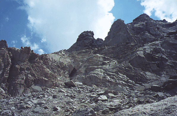 Our route avoided all the apparent cliffs to the right by going
above the towers you see from the top of the talus fan). The alcove marks
the top of the talus fan, and there's about 200' of dangerously loose
low third class crap to scramble through. The footing below the alcove
is OK, but not great. Just above the alcove the whole hillside moves when
you do, and we took turns running the gauntlet while the people below hid.
Our route avoided all the apparent cliffs to the right by going
above the towers you see from the top of the talus fan). The alcove marks
the top of the talus fan, and there's about 200' of dangerously loose
low third class crap to scramble through. The footing below the alcove
is OK, but not great. Just above the alcove the whole hillside moves when
you do, and we took turns running the gauntlet while the people below hid.
What Secor isn't clear about is that Center Peak's west and north face routes actually join behind the prominent tower that tops the north buttress.
See picture of the west side of Center Peak (above) for a red line marking our ascent route. We hit the ridge just south of the tower to get our bearings, but you don't need to go all the way up. We stayed behind a few towers but could not follow the actual ridgeline. I suppose that's what makes it a west face route, but really it's a western approach to the north ridge and you climb the west side of the ridge as you go south toward the summit. The route picture shows what I'm calling the top of the north buttress, and it shows the "tunnel" that you have to climb through to get to the scary crack traverse which leads you to the saddle north of the actual summit. Next time, if there IS a next time, I'll walk up the trail until it makes its final turn south toward Forester, and try the SOUTH RIDGE of Center Peak... looks easier. We walked off the east side and around the north shoulder of the peak to avoid the terrible descent.
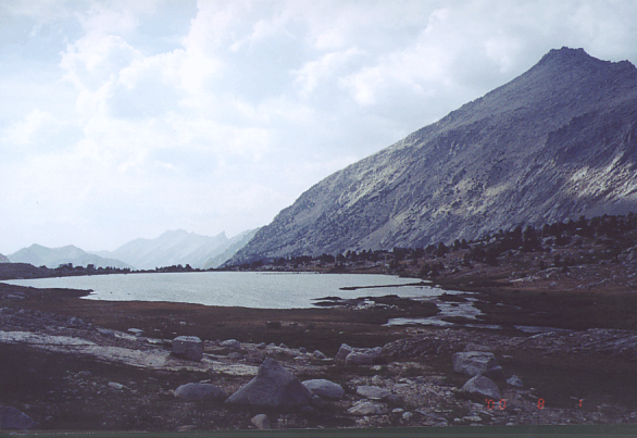
The view of University from Center Basin
covers tundra to clouds! Clouds built up, especially south of us, but no rain.
Our campsite, where the trail turns at about 11300', was apparently constructed by the Boy Scouts in the early 50's... there are a lot of great spots in some trees, all obviously dug into the hillside and somewhat littered with trash. Lots of use here, so if you want privacy hike on up to the lake at 11700' (NOT on the trail) and continue cross country to Stanford from there (or continue cross country and pick up the trail to the south).
For GPS users, here are waypoints for where we left the trail, just above the alcove, at the saddle above the north buttress, at the tunnel, and the point where I took the picture (which would be a better place to start the approach):
![]() Download the Waypoint+ data below as a GPX file for your GPS.
Download the Waypoint+ data below as a GPX file for your GPS.
Datum,North America 1983,GRS 80,0,-1.6E-7,0,0,0
RouteName,1 ,SAVED WAYPOINTS
RoutePoint,D,STRAIL, 36.7222677469,-118.3714609146,08/14/2000,22:03:49,SOUTH TRAIL INTERSECTION
RoutePoint,D,NTRAIL, 36.7256066799,-118.3703557253,08/14/2000,22:03:49,NORTH TRAIL INTERSECTION
RoutePoint,D,ALCOVE, 36.7239704132,-118.3652653694,08/14/2000,22:03:49,
RoutePoint,D,NORBUT, 36.7245175838,-118.3631361723,08/14/2000,22:03:49,NORTH BUTTRESS SADDLE
RoutePoint,D,TUNNEL, 36.7233488560,-118.3628579378,08/14/2000,22:03:49,
RoutePoint,D,CENTEP, 36.7218799591,-118.3627500534,09/02/2005,14:31:54,8_11 CENTER PEAK 12730
The next morning we got up before dawn and made an early start on
Mt Stanford - racing back to camp as it started to rain. Most piled
into their tents, but I used my groundcloth and rain pants and
sleeping pad to construct a shantytown shelter
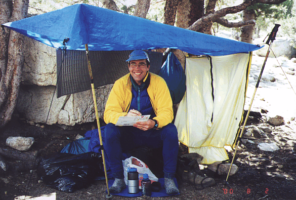
so I could enjoy the intermittent views, including this one with low
drifting clouds near the south shoulder of Center Peak
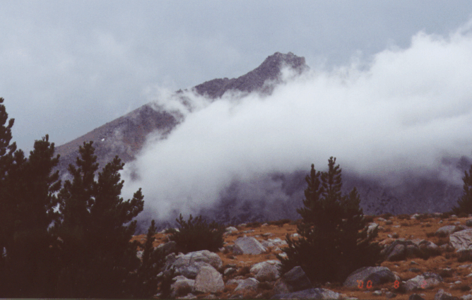
and write a note to my wife (it's hard to write letters in a bivy
bag, and I had no tent).
We hiked out the next day, which ended in steady rain where we were and a snowstorm (in AUGUST) in Yosemite. Of course, the NEXT day was great and we could have climbed Stanford had we sat out a second rainy day.
Jeff Gomillion asked, about East Vidette:
Thanks for getting back to me. Your comments on your ascent linked up for me a quandry we had in the SE basin- the gully that goes North(from our vantage point), just East of (or below) the huge gendarme looked like the way to go to get on the East Ridge, but the Southern traverse of the Gendarme looked very difficult, and we had no way of knowing what lay on the North Side, so on we went in search of that SE chute My usual climbing partner, John Jensen, who is just a few mountaineers peaks away from his Master Emblem in the SPS, will appreciate this information greatly.
Aaron Schuman replied:
Charles and I kind of threaded our way through the gendarme, finding our route this way and that. It seemed like in general, it was steeper and blanker on the south side, and relatively more broken and brushy on the north side.
Charles Schafer adds:
I think Aaron has pretty well described our route and observations. However, I did have a quick discussion with Steve Eckert about his route, and he said that they went around the gendarme to the left (south). But they were already on the ridge, and probably found a weakness right alongside the gendarme - I don't know that it would be possible to access the ridge at that point. It would probably be better to try to get on the ridge a bit below the gendarme (to follow our descent route). Steve's route sounded like it was more straightforward than ours, by the way.
Richard Carey adds:
I parted with Steve, Aaron and Charles at about 8:30 Thursday morning a short way down from camp. I stashed my pack and headed into Center Basin. I saw Jim and Joe and crossed in front of them and stopped by a big boulder below Bradley. It hailed at about 9:30 as I munched on my last mouldy sandwich. It cleared quickly so I headed up the talus slope to Bradley. I saw Jim and Joe take a break below and then head toward Mt. Keith. Also, looking north, I saw two people going up to University Pass and suspected it was Linda and Tim. I thought no one else would be crazy enough to try it so it had to be them!
It was slow going up the loose talus and I made it to the crest at about noon. There were loud booms and lots of dark clouds over by Stanford so abandoning that climb was the right decision.
There were dark clouds coming my way from the south so I went around the east side and found a 30 foot slot that led up to the top. I left my pack below and hurried over to the register can, signed in, and got out of there fast. As I started down it started to rain and I heard a loud boom pretty close. I moved to the right to get under a big chockstone and set my pack down. As I was trying to get settled my pack rolled away slowly. I lunged for it but couldn't reach it. I watched it tumble down about 300 feet and finally stop. It then stopped raining and the sun came out as I went down to my pack. The top zipper had come open and compass and other stuff had fallen out the last twenty feet. I gathered up everything and found the pack dusty but not damaged. GPS and Ham radio were OK.
The sky cleared up for a while as I headed down to my pack. I followed the trail down to the junction. At about 4:30 it rained really hard for about half an hour and I stood under several trees which provided some shelter. Then it slowed and I hiked up to just east of the junction on the way to Bullfrog Lake and camped.
Friday the weather was perfect and the monsoon system seemed to have past. It took me two hours to get up to the pass after a late start drying things out. As I reached Kearsarge Pass at 11:00am a fellow came up running with a waist pack from the west. He said he started at Cedar Grove at 6:00am and would go down to Onion Valley and camp with friends and then run back the next day!
I decided to climb up Mt. Gould which took about an hour and a quarter from the pass. Views from Gould were excellent with some puffy clouds developing in the afternoon in typical Sierra fashion. From the pass it took me two hours to reach the trailhead. There were a lot of people hiking in.
I camped on the four-wheel drive spur down the road and climbed Independence Peak Saturday morning. It was smoky again from a fire on the east slopes of the Sierra not far north. I got down to the truck at about noon and after lunch at Subway started the drive home. South of Lone Pine my air-conditioner conked out so it was a long, hot ride home. I found my left headlight had burned out too as I got home after dark at about 8:30pm.
Mark Adrian adds:
As it turns out, we continued (via Shepherds), but I was very leary. It pounded rain on and off wed and thurs, stopping us several times with massive thunder and lightening "risks". After we made it over Sheperd Pass around noon thursday, we were in and out of layers every ten minutes. It would rain, then clear, then recycle. About 3 PM thurs we got the hell pounded out of us with marble-sized hail and thunder and lightening, enough so to force a chinese fire drill and set up a tent to huddle in. Ironically, friday, sat and sund were picture perfect, dry, warm (almost hot) with some minimal afternoon puffs.
I tried a new approach to Stanford, coming at it from the JMT from near diamond mesa and trying to hit the ridge north of caltech. after three hours of seductive slogging and some 3rd class groping, we got way stalled out by cliffs and exposure which didn't reveal themselves so dramatically on the topo. oh well, we did the E ridge on Caltech as a contingent which is probably low 3rd in a couple spots. Next day, coming from Lake S America, I aborted a 2nd attempt on Stanford and discourage now twice, packed up, tail between my legs, leaving ericson snearing at me and headed home. sigh.
| The 10-year history of Climb-O-Rama's: | ||
| 1996 | Great Western Divide | first trip named 'Climborama', over Shepard Pass to Milestone Basin |
| 1997 | Climborama 97 | a decentralized affair in the Evolution region |
| 1998 | Duke Newcomb and the 16 Peaks | the most prolific Climb-O-Rama ever, in the Whitney area |
| 1999 | Mosquito March '99 | subgroups forming and dissolving from Taboose Pass to Cartridge Pass |
| 2000 | Climborama V | rain and hail ended this Kearsarge Pass and Center Basin trip early |
| 2001 | Climb-O-Rama 2001 | Crowd-O-Rama had a very large group, from Bear Creek to Lake Italy |
| 2002 | Lawd Have Merced | a one-way congenial trip from Yosemite Valley to Tuolumne Meadows |
| 2003 | From Roaring to Lion (The Triple Trip) | our exit was blocked by a forest fire on this Colby Pass area trip |
| 2004 | WESTERN Great Western Divide | unrelenting bad weather on the seldom-visited side of the Milestone Basin |
| 2005 | Climb-O-Rama X (Black and White) | horses made the approach to Blackcap Basin and White Divide easier |