Jim Ramaker has already sent out some highlights of this year's Climb-O-Rama (a trip designed for deep penetration peak bagging far from the cars and weekend warriors), and he did a great job of capturing the "feel" of the trip. (The other approach to some of these peaks is from Horseshoe Meadow, which I used for my 2005 return to the area.)
I'd like to add a few navigation details for the record... and didn't want that "Duke Nuke 'Em" trip title to fade from memory. (We thought of it climbing Newcomb, which was NOTHING like the video war game starring Duke.)
Anyway, Bob Suzuki and I spent quite a bit of time poring over maps, extracting elevation/mileage profiles from TOPO! cdroms, and browsing the SPS and PCS web archives for old trip reports. We found some surprising routes that you might not think of from reading the guidebooks alone, and (except the Hitchcock ridge) they worked out pretty much as planned.
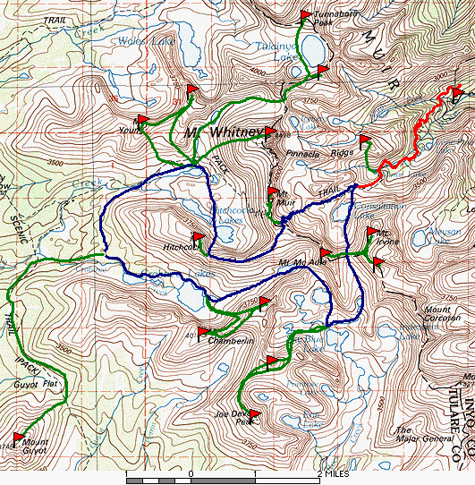
For a map of our trip (peaks and routes), refer to the static topo map and link to a dynamic overlay on Google Maps below. The static map shows the detail of the actual routes we took between waypoints (one-way cross-country backpack travel is in blue, day hikes are in green, the trail walk is in red). The cleaned up GPS waypoints are organized by day into separate routes and are included at the bottom of this report with a link to view them on a live map.
Day 1 saw us lazing around the trailhead repacking and getting acquainted. We were supposed to leave early, but that's hard to do when you're trying to think of reasons NOT to hoist 65 pounds onto your back. (Adequate food for a week is over 20 pounds, plus we had beta indicating both crampons and snowshoes were needed.) We made it to the Trail Camp Slum (two-story solar outhouses in the wilderness?) in time to watch the crazies fall through the ice, to be offered a swig from a two liter jar of vodka, to watch people shred garbage bags glissading down from Trail Crest, etc. It was not as crowded as we expected, mostly because there were rocks but no dirt showing. Lots of snow! (waypoint TRCAMP)
Day 2 we left all that behind. Humping packs up 1500' to the ridge just south of Trail Crest (see waypoint HRIDGE) took a couple of hours. None of the switchbacks were showing, so we just kicked steps in crampons. Rocket Scientists in running shoes were observed using trowels (aka "shit shovels") instead of ice axes. One of them carried a rock, hoping to bang it into the ice and hang on if he slipped. I (and others) pointed out the danger to them and the people below them, but this just generated a caustic reply. We dropped our packs (and part of the group) and hiked along the bare west side trail to the base of Muir. Muir is a nice short climb, which really is moderate class 3 if you stay on route. Some had been there before, obviously on different routes, and entertained us with stories of completely unnecessary hideous exposure.
Back to the packs for lunch, we headed down the ridge to Hitchcock. If you have a chance to do this route, don't. It's a boulder hop. It might be OK with daypacks and no snow, but we had full packs and the snow was thin enough we punched through. It was tedious except where there was a hard patch: Two people had to do self arrests but we finally made it to the saddle just west of Hitchcock (HITSAD). Two people were tired and worried about the coming dark, so they headed down to find a campsite between the Hitchcock lakes (see waypoint HITUPL). The rest of us blew up Hitchcock and arrived in camp after sunset. In my opinion, this was our most stunning campsite, with cliffs all around and sunset over a lake.
Day 3 we packed over to our intended campsite north of Guitar Lake (waypoint GUITAR) where a melted-out slab provided another island of comfort in a sea of snow. The lake was (like Hitchcock lakes) frozen over and the snow was crampon hard in the morning. We went around the corner to climb Hale and Young from the bowl between them, mostly on perfect snow. It softened a bit in the afternoon and several of us put our snowshoes on for the only time the whole trip. (Wasted weight, but good insurance.)
Day 4 we split up: Eddie and I did Tunafish, Jim and Craig did Whitney, Aaron went back for Hitchcock, Bob worked on his suntan. Following an old SPS trip report, Eddie and I flew up the perfect snow past Arctic Lake to the Whitney/Russell saddle hoping we could get to Carillon without losing altitude. I'm going to suggest to Secor that the traverse from the Whitney Russell (W/R) Saddle to the Russell Carillon (R/C) Saddle be dubbed "The Van Dalsem Traverse", in honor of Dale Van Dalsem who documented it in 1989 and has since passed away. It gets you below the south face of Russell in good style, cutting between 4th and 5th class cliffs with class 2 ease.
When climbing to the W/R pass from the east, you don't go to the true low point because there are nasty cliffs below it. (The pass is south of a cleaver from the saddle.) If you are heading from the W/R saddle to the R/C saddle, use the sandy west side to reach the TRUE low point, then go north down 50' of 2nd class "stairs" to an area of sandy ledges and slab boulders. We had some snow to kick steps in here, but mostly it was melted out. Traversing the ledges is truly easy, but don't look down. You are above many hundred feet of cliffs and below even more of the south face of Russell. Take the very highest (on the left when facing Carillon) chute leading toward the R/C saddle (see waypoints BOTTOM and TOP). The lower chutes will waste your time. The correct chute dumps you onto the east ridge of Russell just as the plateau is narrowing into a true ridge. It's a short walk from there to the R/C saddle, which is steep on the north side but fairly easy 2nd class in spite of how it looks. Tunafish (aka Tunaboring or Tunnabora) is an hour each direction from the R/C saddle and has awesome views as a reward for the boring slog.
11 hours of day hiking were followed by 2 hours of moving camp from Guitar toward Crabtree Lakes. We didn't make it all the way to the lake, but found a wonderful spot beside a bubbling stream. Tall trees, clean sand, and a big cliff made this a protected and secluded spot to camp (waypoint CRABV) at just over 11000'.
Day 5 was the only day we didn't move our packs! We hiked on surprisingly snow-free trail from Crabtree Meadow over to Mt Guyot. 10 hours round trip was not a blistering pace, but we needed an easy day. The 4-way intersection of major drainages (Kern et. al.) captured our attention, but the glissade down the NE bowl of Guyot was the high point of the day. The Guyot register (waypoint GUYOTR) is not on the summit marked on the maps (waypoint GUYOTB): The map shows the western bump as the high point, and that is where the USGS benchmarks are, but the register is 0.1 miles east in a more interesting pile of boulders. We did 'em both "just in case".
Day 6 we moved our packs to the inlet of Upper Crabtree Lake (waypoint CRABUP) where slabs and gravel provide good camping if your tent does not blow into the lake. (Tim had stuff in it, but wound up chasing it toward the cliff as it pretended to be a tumbleweed in spite of the weight.) Carry duct tape to repair tent flys!
Another correction to Secor: He says the pass between Chamberlin and Newcomb is class 2 from the north. Maybe. I don't think so. The low point between these peaks is in the middle of a high 3rd class ridge with cliffs on both sides, and NEITHER peak can be reached on 2nd class from that low point. We chose a route east of the low point which was mostly a snow chute but turned into 3rd class near the top (see waypoints CNBOT and CNTOP). On the way down we found a truly 2nd class chute which can be approached the same way (CNBOT) but which goes up to the east and tops out at the SW corner of Newcomb's summit plateau (at waypoint CNEASY). There is a 2nd class traverse to Chamberlin from here if you drop 500' below the cliffy ridgeline on the south side. We made better time down on the sand (going east) than we did up on the ridgeline (going west) but it's less interesting.
Day 7 we cramponed up to Crabtree Pass (SW of McAdie) and dropped down toward Sky Blue Lake to camp. There is a pretty tall waterfall here, so stay west to avoid cliffs. We turned west to camp before reaching Sky Blue, because we were headed for Pickering and Joe Devel the same day (waypoint SKYCMP) and didn't want to do any extra gain. Another rock island in the snow, it reached the low 20s that night and froze half an inch of ice on the hole we chopped for water.
The climb of Pickering was uneventful, but the traverse to Joe Devel was a race against time. We had frittered away much of the day, and read with interest the Pickering register entries which logged how many minutes it had taken people to go one way. Hint: It's best to stay (south) below the ridge of Pickering until you reach the first low point, then stay RIGHT ON the ridge toward Joe Devel until you reach a broad sandy saddle, then stay on the right (west) side the rest of the way to Joe Devel. It's 3rd class along the ridge, but much faster going (and more fun) than the 2nd class traverse we did first. For the record, we reached Joe Devel one hour and forty minutes after leaving Pickering, as part of a 12 hour day.
Day 8 we cramponed up to Arc Pass, from where we climbed McAdie using the standard route. It was more interesting with snow, especially since that snow was soft on top with an ice layer and then sugar snow on the bottom. I argued strongly that it was not safe, and we climbed mostly on rocks. By the time we descended it was soft enough to try glissading. Bob triggered a small avalanche that spread sideways quickly... confirming the conditions I worried about. It's hard to arrest when the whole slope is moving!
It appears to me that there is a second class chute from Crabtree Pass all the way to the 2nd class ledges after the notch in Secor's standard 3rd class route. [NOTE: I went back and climbed this chute in 2005!] I looked up the chute from the bottom, and down the chute from the top, but didn't do it. If it actually connects with no cliffs, McAdie should be downgraded from 3rd class to 2nd class in the SPS Peaks List. It's certainly the long way around, but I've never seen mention of a 2nd class route before.
From Arc Pass, 4 of us headed down to the cars the same day. Bob, Jim, and Eddie headed up to Mallory and Irvine (planning to do Thor on the way out the next day) while Craig and I blew out to the cars at top speed leaving Aaron and Tim free to walk at a more relaxed pace. Craig dropped me off at the Horseshoe Meadow trailhead for a Sunday dayhike of Muah, then returned to ride home with Tim and Aaron. Sunday I bagged Muah and hitched a ride back to Whitney Portal just as the others were hiking out.
Quite a trip! Hopefully these navigation notes will help others the way Van Dalsem's notes helped us. It sounds like we were just out for numbers, but I can assure you that the beauty and isolation were not lost on us. Valley after valley with no people and no tracks. Peak after peak climbed only in the summer or on skis in the winter. We had a whole year's worth of experiences (17 peaks) packed into one week, so each telling of the tale is a bit different and perhaps a bit too long. Thanks for listening, and thanks in advance for sharing YOUR stories and tips with the rest of us.
![]() Download the Waypoint+ data below as a GPX file for your GPS.
Download the Waypoint+ data below as a GPX file for your GPS.
Datum,North America 1983,GRS 80,0,-1.6E-7,0,0,0
RN,1 ,CLIMBORAMA DAY 1
RP,D,PORTAL, 36.586516500,-118.2394982222,07/29/1998,16:40:12,WHITNEY PORTAL
RP,D,MIRLAK, 36.570594908,-118.2618946675,07/29/1998,16:40:12,MIRROR LAKE JCT
RP,D,LNPNCK, 36.567853690,-118.2627583388,07/29/1998,16:40:12,LONE PINE CREEK
RP,D,TRCAMP, 36.563782097,-118.2783848885,07/29/1998,16:40:12,TRAIL CAMP
RN,2 ,CLIMBORAMA DAY 2
RP,D,TRCAMP, 36.563782097,-118.2783848885,07/29/1998,16:40:12,TRAIL CAMP
RP,D,HRIDGE, 36.558669806,-118.2900793198,07/29/1998,16:40:12,RIDGE TO HITCOK
RP,D,TRCRST, 36.559152604,-118.2913506869,07/29/1998,16:40:12,TRAIL CREST
RP,D,MUIR , 36.564758421,-118.2914472464,07/29/1998,16:40:12,MT MUIR
RP,D,HITSAD, 36.550982595,-118.3091873769,07/29/1998,16:40:12,HITCOK SADDLE
RP,D,HITCOK, 36.554807425,-118.3117408399,07/29/1998,16:40:12,MT HITCHCOCK
RP,D,HITUPL, 36.557784677,-118.3079642057,07/29/1998,16:40:12,CAMP UP HIT LK
RN,3 ,CLIMBORAMA DAY 3
RP,D,HITUPL, 36.557784677,-118.3079642057,07/29/1998,16:40:12,UPPER HITCOK LK
RP,D,GUITAR, 36.572032572,-118.3137524966,07/29/1998,16:40:12,CAMP N OF GTR L
RP,D,HALE , 36.588077546,-118.3144176845,07/29/1998,16:40:12,MT HALE
RP,D,YOUNG , 36.581726075,-118.3271581773,07/29/1998,16:40:12,MT YOUNG
RP,D,GUITAR, 36.572032572,-118.3137524966,07/29/1998,16:40:12,CAMP N OF GTR L
RN,4 ,CLIMBORAMA DAY 4
RP,D,GUITAR, 36.572032572,-118.3137524966,07/29/1998,16:40:12,CAMP N OF GTR L
RP,D,ARCTIC, 36.581559778,-118.3085007314,07/29/1998,16:40:12,ARCTIC LAKE
RP,D,RUSPAS, 36.585942508,-118.2884807233,07/29/1998,16:40:12,WHIT RUS PASS
RP,D,RUSSAD, 36.586259008,-118.2888347749,07/29/1998,16:40:12,WHIT RUS SADDLE
RP,D,BOTTOM, 36.588490606,-118.2850689534,07/29/1998,16:40:12,CHUTE TO CARILN
RP,D,TOP , 36.590958239,-118.2831538562,07/29/1998,16:40:12,CHUTE TO CARILN
RP,D,CARSAD, 36.591548325,-118.2811475638,07/29/1998,16:40:12,CARILLON SADDLE
RP,D,TUNBOR, 36.605152489,-118.2821775321,07/29/1998,16:40:12,TUNNABORA PEAK
RP,D,CARILN, 36.592272521,-118.2777197007,07/29/1998,16:40:12,MT CARILLON
RP,D,TOP , 36.590958239,-118.2831538562,07/29/1998,16:40:12,CHUTE TO CARILN
RP,D,RUSSAD, 36.586259008,-118.2888347749,07/29/1998,16:40:12,WHIT RUS SADDLE
RP,D,ARCTIC, 36.581559778,-118.3085007314,07/29/1998,16:40:12,ARCTIC LAKE
RP,D,GUITAR, 36.572032572,-118.3137524966,07/29/1998,16:40:12,CAMP N OF GTR L
RP,D,WHITNY, 36.578507424,-118.2922894601,07/29/1998,16:40:12,MT WHITNEY
RP,D,TIMBER, 36.567499638,-118.3284724597,07/29/1998,16:40:12,TIMBERLINE LAKE
RP,D,CRABV , 36.554072500,-118.3344537858,07/29/1998,16:40:12,CRABVALLEY CAMP
RN,5 ,CLIMBORAMA DAY 5
RP,D,CRABV , 36.554072500,-118.3344537858,07/29/1998,16:40:12,CRABVALLEY CAMP
RP,D,CRABMT, 36.550156475,-118.3576548938,07/29/1998,16:40:12,CRAB MDW TRAIL
RP,D,GUYOTR, 36.510089637,-118.3622146491,07/29/1998,16:40:12,MT GUYOT REG
RP,D,GUYOTB, 36.508920194,-118.3628208283,07/29/1998,16:40:12,MT GUYOT BM
RP,D,CRABMT, 36.550156475,-118.3576548938,07/29/1998,16:40:12,CRAB MDW TRAIL
RP,D,CRABV , 36.554072500,-118.3344537858,07/29/1998,16:40:12,CRABVALLEY CAMP
RN,6 ,CLIMBORAMA DAY 6
RP,D,CRABV , 36.554072500,-118.3344537858,07/29/1998,16:40:12,CRABVALLEY CAMP
RP,D,CRABUP, 36.542716027,-118.3091927413,07/29/1998,16:40:12,UP CRAB LK CAMP
RP,D,CNBOT , 36.536697150,-118.3031202201,07/29/1998,16:40:12,CHAM NEWC CHUTE
RP,D,CNTOP , 36.535763741,-118.3018756751,07/29/1998,16:40:12,CHAM NEWC CHUTE
RP,D,CHAMBR, 36.533580423,-118.3107108716,07/29/1998,16:40:12,MT CHAMBERLIN
RP,D,NEWCOM, 36.540076734,-118.2935661916,07/29/1998,16:40:12,MT NEWCOMB
RP,D,CNEASY, 36.538107992,-118.2985872868,07/29/1998,16:40:12,CHAM NEWC CL 2
RP,D,CNBOT , 36.536697150,-118.3031202201,07/29/1998,16:40:12,CHAM NEWC CHUTE
RP,D,CRABUP, 36.542716027,-118.3091927413,07/29/1998,16:40:12,UP CRAB LK CAMP
RP,D,CRABPS, 36.548708082,-118.2811475638,07/29/1998,16:40:12,CRABTREE PASS
RP,D,SKYCMP, 36.535082460,-118.2815069798,07/29/1998,16:40:12,NEAR SKYBLUE LK
RN,7 ,CLIMBORAMA DAY 7
RP,D,SKYCMP, 36.535082460,-118.2815069798,07/29/1998,16:40:12,NEAR SKYBLUE LK
RP,D,PICRCK, 36.527062655,-118.2908303384,07/29/1998,16:40:12,PICKERING ROCKS
RP,D,PICREG, 36.527223588,-118.2919515017,07/29/1998,16:40:12,PICKERING REGIS
RP,D,JOEDEV, 36.515400411,-118.2964683417,07/29/1998,16:40:12,JOE DEVEL PEAK
RP,D,SKYCMP, 36.535082460,-118.2815069798,07/29/1998,16:40:12,NEAR SKYBLUE LK
RN,8 ,CLIMBORAMA DAY 8
RP,D,SKYCMP, 36.535082460,-118.2815069798,07/29/1998,16:40:12,NEAR SKYBLUE LK
RP,D,ARCPAS, 36.551572681,-118.2706708554,07/29/1998,16:40:12,ARC PASS
RP,D,MCADIE, 36.551717521,-118.2762176637,07/29/1998,16:40:12,MT MCADIE
RP,D,MALORY, 36.548901201,-118.2622111682,07/29/1998,16:40:12,MT MALLORY
RP,D,IRVINE, 36.555762292,-118.2634825353,07/29/1998,16:40:12,MT IRVINE
RP,D,CONSUL, 36.563491915,-118.2698949426,07/29/1998,16:40:11,CONSULTATION L
RN,9 ,CLIMBORAMA DAY 9
RP,D,CONSUL, 36.563491915,-118.2698949426,07/29/1998,16:40:11,CONSULTATION L
RP,D,THOR , 36.576651336,-118.2654995564,07/29/1998,16:40:12,THOR PEAK
RP,D,MIRLAK, 36.570594908,-118.2618946675,07/29/1998,16:40:12,MIRROR LAKE JCT
RP,D,PORTAL, 36.586516500,-118.2394982222,07/29/1998,16:40:12,WHITNEY PORTAL
| The 10-year history of Climb-O-Rama's: | ||
| 1996 | Great Western Divide | first trip named 'Climborama', over Shepard Pass to Milestone Basin |
| 1997 | Climborama 97 | a decentralized affair in the Evolution region |
| 1998 | Duke Newcomb and the 16 Peaks | the most prolific Climb-O-Rama ever, in the Whitney area |
| 1999 | Mosquito March '99 | subgroups forming and dissolving from Taboose Pass to Cartridge Pass |
| 2000 | Climborama V | rain and hail ended this Kearsarge Pass and Center Basin trip early |
| 2001 | Climb-O-Rama 2001 | Crowd-O-Rama had a very large group, from Bear Creek to Lake Italy |
| 2002 | Lawd Have Merced | a one-way congenial trip from Yosemite Valley to Tuolumne Meadows |
| 2003 | From Roaring to Lion (The Triple Trip) | our exit was blocked by a forest fire on this Colby Pass area trip |
| 2004 | WESTERN Great Western Divide | unrelenting bad weather on the seldom-visited side of the Milestone Basin |
| 2005 | Climb-O-Rama X (Black and White) | horses made the approach to Blackcap Basin and White Divide easier |