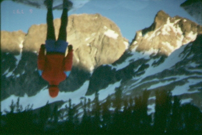
Climborama 97 was a decentralized affair. Ten PCS climbers ventured into the Evolution region during the first eight days of July, and we all climbed various peaks with various combinations of partners during that time. Charles Schafer and I (Jim Ramaker) climbed together all week, and this report covers the trip from our perspective.
On Wed. morning July 2, Charles and I drove down to North Lake after spending a restful night at David Harris's condo in Mammoth. David, Steve Eckert, and John Bees followed in another car -- they were hiking over Paiute Pass to climb Goethe on the way in, while Charles and I were heading over Lamarck Col.
The Lamarck Col route is basically a trail rather than a cross-country route, even though it's not marked on the 15' map. Then only tricky part is finding where it leaves the official trail between Lower and Upper Lamarck Lakes. We cut off at the first creek crossing, about 1/3 of the way from the lower to the upper lake. Looking down on this section later on, we saw that there are actually two parallel trails leaving the main trail, with the second one cutting off about 2/3 of the way from the lower to the upper lake. After less than a mile, the two trails join and proceed past some beautiful small lakes and up a long steep hillside to some barren slopes and plateaus above. I got up near Lamarck Col around 4 and talked to some campers there, then decided to dash up Mt. Lamarck (13,417'), because Charles hadn't appeared yet. (He had a very heavy pack -- his camera lens alone is the approximate size and weight of a brick).
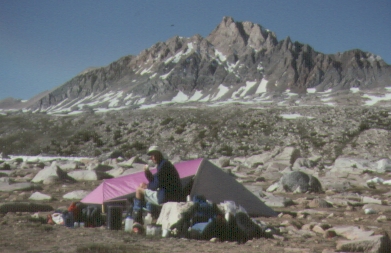
Mt. Lamarck is easy class-2 and took 45 minutes round trip from the trail. When I got down, Charles was there, and we hiked over the col (13,000'), across the Sierra Crest and into Kings Canyon National Park. Then it was down down down to the highest Darwin Lake at 11,800', where we arrived at 7 p.m. Little did we know, but this wild, rockbound lake would be our home for the next three nights. It was a wonderful place, with a few bivvy spots carved out of the rocks by climbers, and too high for any bugs.
Charles and I left for Darwin (13,830') at 7 a.m. Thursday and by 9 we were at the bottom of the gully leading up to the notch in Darwin's west ridge. We passed the vertical section at the bottom of the gully by climbing a steep snow ramp on the right, then climbed mixed class-3 rock and frozen snow in the upper part of the gully. We soon arrived at the notch, a very alpine place -- shady, windy, and icy. We then shed our crampons, turned left, and started up the ridge toward the summit plateau. It was harder than expected, with several class-3 sections and some careful routefinding needed to avoid cliffs to the left and right. By 11 we were on the vast 1000-foot long summit plateau.
I'd been harboring secret hopes that maybe the famous Darwin summit pinnacle had fallen over in an earthquake or been dynamited by some merciful soul. But halfway across the plateau it suddenly appeared, rearing up above the horizon like a grotesque nightmare, an unsteady stack of square blocks with a weird pointing finger formation on top, as if pointing the way to our doom.
I didn't like the massive exposure around the pinnacle, and the two steep gullies leading over to it were filled with steep, soft, and unstable snow. I climbed down the first one unroped, then retreated, sat down in a funk, and suggested we just forget about the pinnacle and go down. But Charles was not to be denied. He perused the situation from various angles, then figured out a way to set up a solid belay that would protect both snow gullies.
After more delay, I finally agreed to try it. I tied in, climbed quickly down one snow gully and up the other, found a stance on the far side of the pinnacle, and belayed Charles over. While I was rearranging the rope, he floated up the class-3 crack and hopped onto the summit without a belay!! I followed suit, and we both found the last part of the pinnacle much easier than expected. I'd been told to expect a tricky mantle with 1500 feet of exposure, but if you move as far to the right as possible before doing the mantle (more on the east side of the pinnacle instead of the southeast), you have a nice flat ledge below you and the exposure is more like 6 feet instead of 1500 feet. As long as you fall off the mantle in an orderly manner, you'll land on that ledge.
Since we found the descriptions of how to climb the pinnacle confusing, here is mine (don't read this if you want to preserve a little mystery):
After climbing back to the plateau, we took a long break and then descended the mountain. Back on the glacier around 5:30 p.m., Charles announced that we had to climb Mendel (13,691') today. I suppressed a groan, then led across the glacier to a prominent right-slanting snow gully near the bottom right center of Mendel's steep east face. The snow was soft, steep, and carved into deep suncups, so that when you were standing in the bottom of one, the top of the next one was in front of your face. We climbed about 500' on this happy terrain, then exited left onto a wide, flat ledge. After about 50', this led us to another right-slanting gully that we climbed till it ended. From there, we couldn't figure out the correct route on the wide face above, and since it was going on 7 p.m., we bailed for the day.
A strange kind of euphoric exhaustion overtook me as I descended the glacier to our camp -- we'd fumbled around a bit on one peak and run out of time on the second, but it had been a great, 13-hour day on some of the best alpine terrain in California. The stars and the Milky Way were spectacular that night -- we had no moon for the entire week of the trip -- and I saw over a dozen meteors before drifting off to sleep.
Friday we decided to postpone our plans to hike over and join the rest of the group, and return to Mendel instead. We retraced our steps up onto Darwin Glacier, up the 500' slanting snow gully on Mendel, across the 50' ledge, and up the second gully for about 200' to our high point. From there we traversed left on a second ledge system for about 100', which brought us to the large open scree bowl high on the east face of Mendel. At the top of the scree bowl is a cliff going all the way across the mountain, forming a vertical, 200-foot wall at the upper left, a smaller cliff across the middle, and a small headwall split by a couple of steep gullies on the upper right.
Secor says to go up and left to a chimney, but we just didn't believe him, because the cliff in that area looks vertical and even overhanging. So we wandered up to the right, toward the only obvious weakness in the cliff, on the theory that Secor was wrong and the chockstone was really at the upper right, not the upper left. My interest was piqued when I spotted a gully with a chockstone up there, and near it an old rappell sling. I climbed up the gully and forced my way all the way to the summit ridge, only to find that it was very exposed on both sides, with big awkward blocks barring the way to the summit.
I retreated back to the steep boulders and scree, and discussed various theories with Charles. It was after 12 noon by this time, and we weren't doing too hot on this damn mountain. We still had no idea whether the elusive route was up to the left or right. We did some more wandering back and forth across the face, looking for the magic staircase that would deposit us on the summit plateau. Finally I gave up, sat down, and told Charles it was time to go down. But once again he wouldn't have it, and he wandered up and left toward an unlikely looking cleft just right of the 200-foot high cliff.
There was a chockstone there, in a square chimney marked by bright greenish-yellow lichen. Instead of tackling the chimney, Charles assaulted a vertical 40-foot cliff to its right, working his way up bit by bit on what he claimed were plentiful holds. From my vantage point several hundred feet below, the cliff seemed to be overhanging, and I waited for a scream, clattering rock, and a grim thud. Instead I heard a yell of triumph, and there was Charles on the summit plateau at the top of the cliff. I scrambled up toward him and he offered to belay me up the chimney. The chockstone overhung a little bit and forced me out onto a smooth wall to the left, but with a top rope it was great fun. Although the exposure wasn't bad, I would call the chimney class four because of the awkward climbing on small holds. I would climb it unroped on a good day, but I wouldn't like to downclimb it unroped. A fall, while not fatal, would slam you onto some nasty sharp blocks.
So that's the mystery of Mendel's east face -- just head for the square chimney on the upper left with the greenish-yellow lichen, and bring a short rope (50' is plenty).
Charles and I strolled across the summit ridge to the top at 2 p.m., for another hard-won summit. Views of the central Sierras were again tremendous, and from the edge of the plateau we could see the large lakes of Evolution Valley and the huge dark peaks over in the Goddard area. Around this time Charles and I discovered that our combined ages add up to exactly 100 -- thus the nickname century duo.
We descended the chimney on belay, then downclimbed the steep, loose face and the steep snow gully, finally getting back to the safety of the glacier at 4:30. An hour later, while descending the talus slope to our camp, I spotted two people a couple of thousand feet away, descending the slope opposite us on the way down from Lamarck Col. Both were skinny, one silent, one constantly talking -- it could only be Kelly Maas and Kai Wiedman! We met up with them at the lake, and had a good time visiting each others camps as we cooked supper and discussed the day just past and the day to come. Kai and Kelly were in with two friends to do one of the Mendel couloirs -- possibly the premier technical ice climbs of the Sierras. (They did the climb the next day, and found it to be a real thriller.) Finally Charles and I bade them goodnight and retired to another restful night under the stars.
Saturday we hiked cross-country to rendez-vous with the other climborama climbers in McGee Canyon. (Note: there are two McGee Canyons in the Sierras, and this is the southern one, near Mt. Goddard.) With the early morning sun behind us, hiking down past the series of lakes in Darwin Canyon was exceptionally beautiful, with natural "gardens" of green grass, boulders, bushes, and flowers along the shores of the lakes. We crossed Darwin Bench and found a great staircase route down through some cliffs to the John Muir Trail below Evolution Lake. At that point the fun was over for a while -- the mosquitoes in Evolution Valley were ferocious, and the only solution seemed to be slather on the bug dope and keep hiking as fast as possible.
We hiked up the trail to the far (south) end of Sapphire Lake, then started up the cross-country route over McGee Pass. This is a nice pass -- to avoid the cliffs directly east of the pass, go south all the way to the end of Sapphire lake and then angle back northwestwardly toward the pass, on a line between the pass and the magnificent peak of Mt. Huxley, which stands out in the middle of Upper Evolution Valley.
At the top of the pass I spotted a person down in the trailless valley to the west, and it turned out to be Kalon Kelley, who was hiking out after camping with the climborama group. After talking to him, Charles and I descended the valley and found the climborama camp at Middle McGee Lake about 4 p.m. Camp was deserted except for Tim Hult, lounging in his screen-walled tent to escape the bugs. Charles and I washed up, set up our tent, and took a welcome nap -- the only time in this seven-day trip we had time to do that.
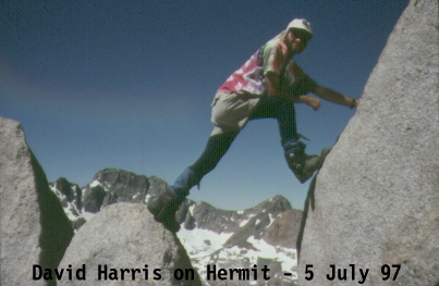
Around 8 p.m., the rest of the group (Steve Eckert, David Harris, Rich Leiker, Don Martin, and Bob Suzuki) started wandering in from a very arduous 14-hour day climbing the Hermit (12,360') and Mt. McGee (12,969'). The Hermit has a technical pitch at the top that Bob Suzuki led at 5.7, while the route on McGee involved crossing a saddle and descending 1000 feet of loose scree on the way to the top, then re-climbing the same 1000 feet to cross the saddle again on the way "down." This was the one real climborama evening of the week, with all eight of us cooking, talking, and camping together in a vast flat sandy area next to the lake. It was another cloudless evening and many of us slept out under the stars.
Sunday the group divided up again, with David Harris, Rich Leiker, and Bob Suzuki joining Charles and me to do Goddard. Our goal was Starr's buttress on the northeast side of the peak -- "an interesting route on an otherwise boring mountain," as Secor describes it.
Our plan was to hike back over McGee Pass to the John Muir Trail, drop our packs near Sapphire Lake, hike up the trail to Wanda Lake, then head cross-country to the foot of Mt. Goddard near its small northeast glacier. We dropped our packs next to the JMT about 9 a.m., then crossed the saddle west of Wanda Lake and gradually descended southwesterly into the Davis Lake basin, with Mt. Goddard looming above us ever higher, blacker, and more threatening.
At 12:30 we finally arrived at the bottom of Starr's Rib, which is the north ridge of peak 12,960+ on the 15-minute map. The first part of the rib was steep class-3, with strange porcelain-like rock with smooth rounded holds. Above that, the buttress has three more sections, all of them with very loose rock -- a long almost level section, a steep part that shoots up several hundred feet, then a final long sidehill traverse that leads to the long and easy east ridge of Goddard. At the start of the flat section, I spotted an exit onto the glacier to our right, and asked if I could go and climb it. Bob said okay, but no one wanted to join me, so I headed off alone.
Secor's photo on page 223 shows this glacier as a rather depressing scrap of snow streaked with rockfall. But in the first week of July it was a generous glacier, with a steep snow couloir above it leading all the way to the saddle between Peak 12,960+ and Goddard, and gentle snow slopes below it leading down past the bottom of Starr's buttress. The steep part of the couloir looked like no more than about 100 feet, and I figured I could handle that. I climbed up and right on the glacier, rested a minute, then headed up the couloir. As the walls closed in it got steeper and steeper until it was well over 45 degrees -- wow, I'd never been on snow this steep. Front-pointing and using the pick of my axe, I felt secure, but what if I slipped? I started climbing faster and faster, and the couloir went on and on. Finally, after more than 500 feet of steep snow, I flopped onto the scree at the top exhausted.
After a few minutes I started up the class-2 slope to the summit, running into Kalon Kelley for the second time in two days in the middle of nowhere. He was descending after a solo climb from Muir Pass. I summitted at 3 p.m., then waited for an hour for my four buddies to finish climbing up from Starr's Buttress. We relaxed on the summit for an additional hour, enjoying the tremendous views for which this isolated peak is justly famous. A weird lethargy overtook us -- a hard descent and miles of rugged cross-country terrain stood between us and our camp, but it seemed better to just lie around on the scree at 13,568'. Finally we shouldered our daypacks and started down.
After a debate about the descent route, we decided to go down Starr's buttress. The sidehill section near the top went okay, though one of us set loose a tremendous rockfall, the kind that raises clouds of dust and clatters and rumbles down into the void for over 30 seconds. Luckily we were traversing and spread out, so it was no threat to anyone. At the top of the steep section, I spotted a exit gully descending steeply to the left down to a snow couloir and then down to the glacier. Soft snow sure looked better than this hideous loose brown rock, and I got permission to check it out. The rock was loose class 3, and the snow couloir below it was steep, but not as steep as the one I'd gone up. Soon I was down on the low-angle part of the glacier, urging the others to follow me.
They reluctantly agreed, but as Bob was descending the snow couloir, someone above knocked loose another rockfall, and two soccer-ball-sized boulders came thundering down the gully toward him. With his usual studied calm, Bob waited till the boulders drew near, then dodged in between them. A close call. Finally we were all down on the glacier, and after an easy walk down the snow, we arrived back at the bottom of Starr's Buttress at 6:30. Thus we really did three different routes on Goddard:
At the bottom of the buttress, we got water and started the long uphill slog across the talus to Wanda Lake. The alpenglow hit as we crested the saddle west of the lake, and the entire lake basin and even the air itself seemed suffused with soft pink light. From there it was down the Muir trail to our packs, then down some slabs to a flat sandy area at the south end of Sapphire Lake, where we set up camp. It was 9 p.m., for a 14-hour day, and incredibly, for David, Rich, and Bob, their *second* 14-hour day in a row.
Monday our plan was up and over the Sierra Crest via the Haeckel-Wallace Col (except for David, who departed for Lamarck Col). We left camp at 8:30 a.m. and hiked up into the very beautiful and nearly untouched alpine valley just east of Sapphire Lake, enjoying the small lakes and meadows, strange rock formations, and excellent views of Mts. Huxley, Warlow, and Fiske just to the south. We climbed higher into more austere alpine terrain of talus, snowfields, and partially frozen lakes, then reached the bottom of the 1000' scree gully leading up to the col at noon. The scree gully was very steep and loose, and at one point part of the group had to take cover while two of us climbed up ahead -- there was just too much rockfall for the four of us to climb at the same time. After two hours in the gully, with time out for breaks and whining, we reached the col at 13,000'.
After a break to eat and put on crampons, we walked over to the base of Haeckel (13,435') as dark clouds moved in from the north. The climb up Haeckel from the south is challenging class-3 but short -- in fact it leaves you wishing it were a lot longer because the climbing is quite interesting. The best route starts about 100' below the south ridge of Haeckel and angles gradually up toward the ridgeline, aiming for a slot about 10 feet below the summit. In 30 minutes we were on top, but just as we started relaxing and enjoying the views, we heard the rumble of thunder from the approaching storm and turned to descend.
Back down on the snowfield at 4 p.m., Charles and I discussed whether or not to do Wallace (13,377) (Bob and Rich had already climbed it). We were pretty tired and it was a long way down to where we wanted to camp, but on the other hand, neither of us had done it and the storm seemed to be breaking up. The argument "How long will it be before we're this close to it again?" easily won out, and we started up the snow that led almost all the way to the top. Some class 2-3 scrambling above the snow took us to the summit, which is an uncomfortable pile of huge thin slabs standing on end.
Charles worked on his photography for awhile, and after a rest, we descended and retrieved our packs. At 7 p.m. we started following in Rich's and Bob's footsteps down to our meeting place at Midnight Lake, 2000 feet below over complex terrain. We were assaulted by bugs on the ridge above Midnight Lake, and we finally spotted Rich's tent and pulled into camp at 9 p.m. After supper I drifted off to sleep with that deeply pleasurable feeling you get on the last night of a long and wonderful climbing trip.
Tuesday morning we got up at 5 a.m. and fled just as the bugs were waking up at 6. With a break for breakfast on the trail, we got down to Lake Sabrina at 10, watched the fishermen on the dam, cleaned up, and headed off to the Bishop Sizzler and home.
| The 10-year history of Climb-O-Rama's: | ||
| 1996 | Great Western Divide | first trip named 'Climborama', over Shepard Pass to Milestone Basin |
| 1997 | Climborama 97 | a decentralized affair in the Evolution region |
| 1998 | Duke Newcomb and the 16 Peaks | the most prolific Climb-O-Rama ever, in the Whitney area |
| 1999 | Mosquito March '99 | subgroups forming and dissolving from Taboose Pass to Cartridge Pass |
| 2000 | Climborama V | rain and hail ended this Kearsarge Pass and Center Basin trip early |
| 2001 | Climb-O-Rama 2001 | Crowd-O-Rama had a very large group, from Bear Creek to Lake Italy |
| 2002 | Lawd Have Merced | a one-way congenial trip from Yosemite Valley to Tuolumne Meadows |
| 2003 | From Roaring to Lion (The Triple Trip) | our exit was blocked by a forest fire on this Colby Pass area trip |
| 2004 | WESTERN Great Western Divide | unrelenting bad weather on the seldom-visited side of the Milestone Basin |
| 2005 | Climb-O-Rama X (Black and White) | horses made the approach to Blackcap Basin and White Divide easier |