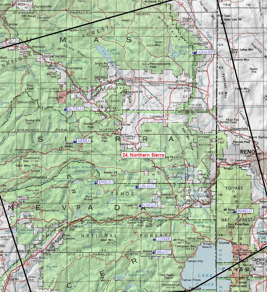
Climber.Org logo

Sierra Nevada Peaks - Region 24
Northern Sierra

Generated on 3 Dec 2008, see revision history for update details.
CORRECTIONS WOULD BE APPRECIATED! contact Steve Eckert.
Search and Navigate  |   Trip Reports  |   Trip Announcements  |   Roster
Driving Directions  |   Reference Data  |   Gear  |   Common Sense Rules!
For more peak data you can:
  • jump to the main Sierra Peaks List page or a clickable Sierra Peaks Map
  • for text only, click on a complete sorted list of all 328 SPS peaks or a short list of 24 SPS peak regions
  • jump to statewide peaks database for CA, CO, NV, OR, and WA (2000 peaks per state)

    Region 24: Northern Sierra, 9 peaks (see a list or map of other regions)


    Map exported from
    TOPO! software, used with permission.

    Northern Sierra
    sorted alphabetically on Waypoint column
    click on these headings to sort by that column click on these headings for more info
    Num Peak Name
    (more links)
    Waypoint Elev SPS ClassPics and
    Reports
    UTM hint
    (map)
    7.5' MapRegister
    24.9Adams PeakADAMSP8197 21 pic of AdamsPeak
    3 reports on adams
    480217Constantia 
    24.3Castle PeakCASTLP9103 2s32 pics of CastlePeak
    6 reports on castle
    285605Norden 
    24.8Elwell MtELWELM7818 13 reports on elwell982977Gold Lake 
    24.6English MtnENGLIM8373 24 reports on english108690English Mtn 
    24.1Granite ChiefGRANIT9006 11 pic of GraniteChief
    9 reports on granite
    344421Granite Chief 
    24.5Lola MtLOLAMT9148 15 reports on lola269679Independence Lake 
    24.4Rose MtROSEMT10776 12 reports on rose486588Mt Rose (Nev)need
    24.7Sierra ButtesSIERRA8591 12 pics of SierraButtes
    5 reports on sierra
    022851Sierra City 
    24.2Tinker KnobTINKER8949 15 reports on tinker344473Granite Chiefneed

    NOTE: M = Mountaineers Peak, E = Emblem Peak, X = not on SPS List (in 'SPS' column)
          ^ = metric contours and elevations on 7.5' maps (in 7.5' map columns)
          Name Mt  => 'Mt' should be before peak 'Name' (ex: Rose Mt is Mount Rose, but sorted on 'Rose')
          Name Mtn => 'Mtn' is after peak 'Name' as listed (ex: Muah Mtn is Muah Mountain)
          Maps listed here are USGS 7.5 minute topo quads
    

    Below are GPS waypoints, in Waypoint+ text format, suitable for downloading to a GPS or importing/viewing in TOPO! software. The comment field contains the exact peak name, as in the various lists of peaks, but may be truncated by your GPS. The waypoint names are all abbreviated to 6 characters. Note that peaks marked by 'X' in the table above are not on the SPS List.

    The first set of data below has decimal degrees, with latitude and longitude after the 3rd and 4th comma. The second set of data shows full UTM zone, easting, and northing after the 3rd, 4th, and 5th commas. The "UTM Hint" in the table above represents the peak location to the nearest 100 meters, use the data below for more precision.


    NAD83 datum, Latitude/Longitude in decimal degrees (UTM below).

    Datum,North America 1983,GRS 80,0,-1.6E-7,0,0,0
    RouteName,24,NORTHERN SIERRA
    RoutePoint,D,GRANIT,39.1982461,-120.2868897,12/03/2008,00:02:32,GRANITE CHIEF
    RoutePoint,D,TINKER,39.2447238,-120.2848690,12/03/2008,00:02:32,TINKER KNOB
    RoutePoint,D,CASTLP,39.3654605,-120.3490846,12/03/2008,00:02:32,CASTLE PEAK
    RoutePoint,D,ROSEMT,39.3437507,-119.9178127,12/03/2008,00:02:32,ROSE MT
    RoutePoint,D,LOLAMT,39.4329362,-120.3650303,12/03/2008,00:02:32,LOLA MT
    RoutePoint,D,ENGLIM,39.4464432,-120.5510507,12/03/2008,00:02:32,ENGLISH MTN
    RoutePoint,D,SIERRA,39.5935787,-120.6468014,12/03/2008,00:02:32,SIERRA BUTTES
    RoutePoint,D,ELWELM,39.7082122,-120.6890996,12/03/2008,00:02:32,ELWELL MT
    RoutePoint,D,ADAMSP,39.9107340,-120.1002241,12/03/2008,00:02:32,ADAMS PEAK


    NAD27 datum, UTM Zone/East/North in decimal meters (degrees above).

    Datum,North America 1927 mean,Clarke 1866 ,-69.4,-0.37264639,-8,160,176
    RouteName,24,NORTHERN SIERRA
    RoutePoint,UTM,GRANIT,10,734388.2,4342088.8,12/03/2008,00:02:32,GRANITE CHIEF
    RoutePoint,UTM,TINKER,10,734408.1,4347253.0,12/03/2008,00:02:32,TINKER KNOB
    RoutePoint,UTM,CASTLP,10,728472.6,4360490.4,12/03/2008,00:02:32,CASTLE PEAK
    RoutePoint,UTM,ROSEMT,11,248628.6,4358784.0,12/03/2008,00:02:32,ROSE MT
    RoutePoint,UTM,LOLAMT,10,726880.0,4367940.0,12/03/2008,00:02:32,LOLA MT
    RoutePoint,UTM,ENGLIM,10,710827.2,4368987.8,12/03/2008,00:02:32,ENGLISH MTN
    RoutePoint,UTM,SIERRA,10,702160.0,4385100.1,12/03/2008,00:02:32,SIERRA BUTTES
    RoutePoint,UTM,ELWELM,10,698200.0,4397730.0,12/03/2008,00:02:32,ELWELL MT
    RoutePoint,UTM,ADAMSP,10,747960.0,4421680.1,12/03/2008,00:02:32,ADAMS PEAK