Sierra Peaks - Region 21
Mt Lyell And North
Generated on 21 Aug 2022 - see revision history - please send updates to the webmaster
|
Mt Lyell And North sorted numerically on Num column | ||||||||||||||
| Click on the peak name for similarly named peaks in a statewide peaks database. | ||||||||||||||
| click on these headings to sort by that column | click on these headings for more info | |||||||||||||
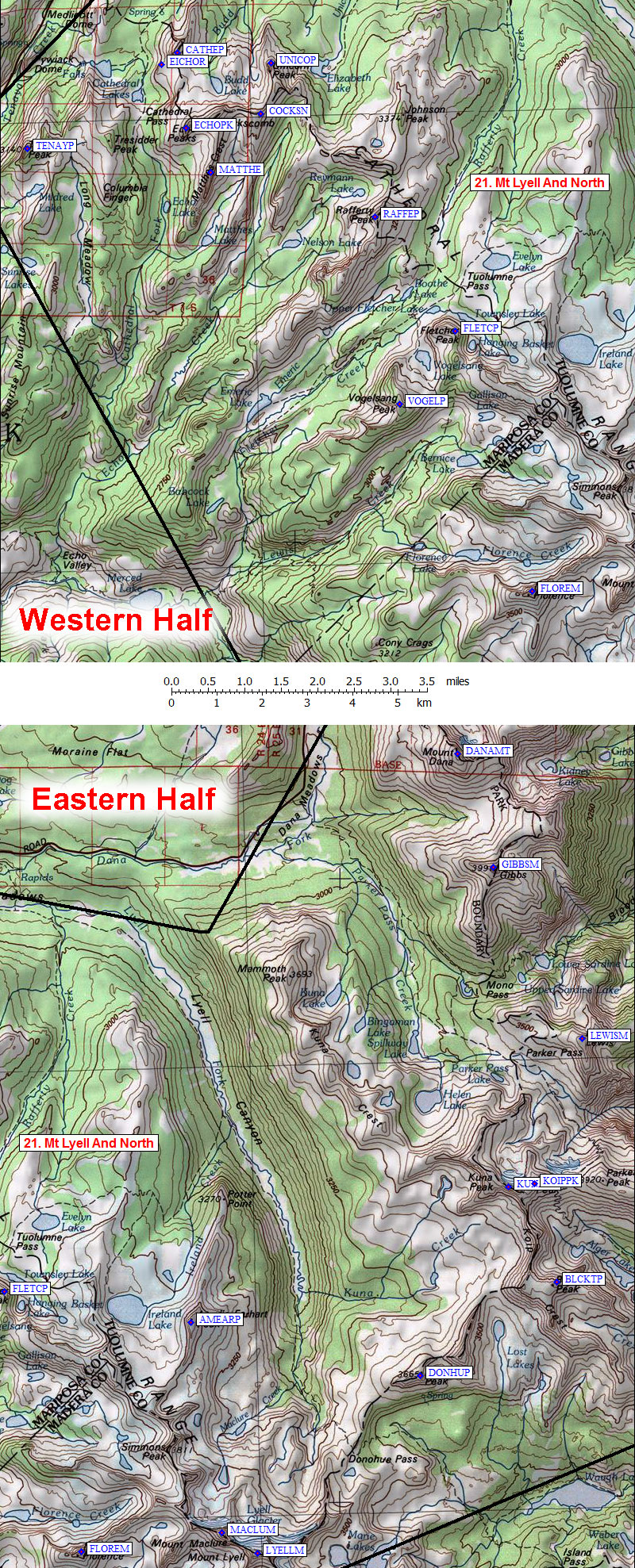
| Num | Peak Name (more links) | Waypoint | Elev | SPS | Class | Pics and Reports | UTM hint (map) | 7.5' USGS topo quad | Register | |||||
| 21.1 | Cathedral Peak | CATHEP | 10911 | M | 3s4 | 1 pic of CathedralPeak 15 reports on cathedral | 884915 | Tenaya Lake | need | |||||
| 21.2 | Vogelsang Peak | VOGELP | 11493 | 2 | 1 pic of VogelsangPeak 4 reports on vogelsang | 932835 | Vogelsang Peak | need | ||||||
| 21.3 | Florence Mt | FLOREM | 12561 | 2 | 10 reports on florence | 960793 | Mt Lyell | |||||||
| 21.4 | Maclure Mt | MACLUM | 12880+ | 3 | 1 pic of MaclureMt 6 reports on maclure | 992796 | Mt Lyell | |||||||
| 21.5 | Lyell Mt | LYELLM | 13114 | E | 3 | 1 pic of LyellMt 9 reports on lyell | 999791 | Mt Lyell | ||||||
| 21.6 | Koip Peak | KOIPPK | 12962 | 1 | 3 reports on koip | 063872 | Koip Peak | |||||||
| 21.7 | Gibbs Mt | GIBBSM | 12773 | 1 | 1 pic of GibbsMt 3 reports on gibbs | 055943 | Mount Dana | need | ||||||
| 21.8 | Dana Mt | DANAMT | 13057 | 1 | 2 pics of DanaMt 15 reports on dana | 048968 | Mount Dana | need | ||||||
| 21.9 | Fletcher Peak | FLETCP | 11410 | X | 2 | 1 pic of FletcherPeak 2 reports on fletcher | 944851 | Vogelsang Peak | ||||||
| 21.10 | Rafferty Peak | RAFFEP | 11110 | X | 2 | 927877 | Vogelsang Peak | |||||||
| 21.11 | Unicorn Peak | UNICOP | 10880 | X | 4 | 1 pic of UnicornPeak 3 reports on unicorn | 905912 | Tenaya Lake | need | |||||
| 21.12 | Cockscomb N | COCKSN | 11040 | X | 4 | 1 pic of CockscombN 6 reports on cockscomb | 902900 | Tenaya Lake | ||||||
| 21.13 | Matthes Crest | MATTHE | 10918 | X | 5 | 1 pic of MatthesCrest 6 reports on matthes | 891888 | Tenaya Lake | need | |||||
| 21.14 | Echo Peaks | ECHOPK | 11160 | X | 3 | 9 pics of EchoPeaks 11 reports on echo | 886898 | Tenaya Lake | ||||||
| 21.15 | Eichorn Pinnacle | EICHOR | 10800 | X | 5 | 1 pic of EichornPinnacle 5 reports on eichorn | 881912 | Tenaya Lake | ||||||
| 21.16 | Tenaya Peak | TENAYP | 10280 | X | 0 | 1 pic of TenayaPeak 6 reports on tenaya | 850894 | Tenaya Lake | need | |||||
| 21.17 | Lewis Mt | LEWISM | 12324 | X | 0 | 074904 | Koip Peak | |||||||
| 21.18 | Kuna Peak | KUNAPK | 13002 | X | 2 | 057872 | Koip Peak | need | ||||||
| 21.19 | Blacktop Peak | BLCKTP | 12720 | X | 2 | 2 reports on blacktop | 067850 | Koip Peak | ||||||
| 21.20 | Donohue Peak | DONHUP | 12023 | X | 2 | 036830 | Koip Peak | |||||||
| 21.21 | Amelia Earhart Peak | AMEARP | 11974 | X | 2 | 2 reports on ameliaearhart | 986843 | Vogelsang Peak | need | |||||
NOTE: M = Mountaineers Peak, E = Emblem Peak, X = not on SPS List (in 'SPS' column)
      ^ = metric contours and elevations on 7.5' maps (in 7.5' map columns)
      Name Mt  => 'Mt' is before peak 'Name' (ex: Rose Mt is Mount Rose, but sorted on 'Rose')
      Name Mtn => 'Mtn' is after peak 'Name' as listed (ex: Muah Mtn is Muah Mountain)
The "UTM Hint" in the table above approximates the peak location to the nearest 100 meters.
Click here for info on Universal Transverse Mercator coordinates.
Useful Links: