Desert Peaks - Region 3
San Bernardino
Generated on 10 Aug 2024 - see revision history - please send updates to the webmaster
|
San Bernardino sorted alphabetically on Waypoint column | ||||||||||||||
| Click on the peak name for similarly named peaks in a statewide peaks database. | ||||||||||||||
| click on these headings to sort by that column | click on these headings for more info | |||||||||||||
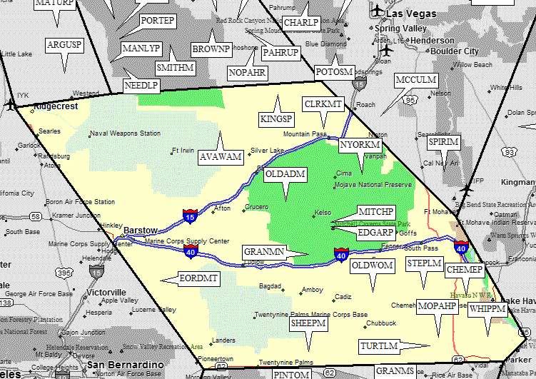
| Num | Peak Name (more links) | Waypoint | Elev | DPS | Class | Pics and Reports | UTM hint (map) | 7.5' USGS topo quad | Register | |||||
| 3.1 | Avawatz Mtn | AVAWAM | 6154 | 1 | 1 report on avawatz | 607299 | Sheep Creek Spring | |||||||
| ?suspended? DPS trip reports have been removed as of 2008 | ||||||||||||||
| 3.13 | Chemehuevi Pk | CHEMEP | 3694 | 2 | 1 report on chemehuevi | 237259 | Chemehuevi Peak | |||||||
| 3.3 | Clark Mtn | CLRKMT | 7907 | 3 | 8 reports on clark | 280321 | Clark Mtn | |||||||
| 3.7 | Edgar Pk | EDGARP | 7162 | 2 | 2 reports on edgar | 337689 | Fountain Peak | |||||||
| Edgar Pk was formerly called 'Providence Peak' by the DPS. | ||||||||||||||
| 3.9 | East Ord Mtn | EORDMT | 6168 | 1 | 1 report on ord | 218329 | Ord Mountain | |||||||
| ?suspended? DPS trip reports have been removed as of 2008 | ||||||||||||||
| 3.8 | Granite Mtn N | GRANMN | 6762 | 2 | 12 reports on granite | 194507 | Bighorn Basin | |||||||
| 3.2 | Kingston Pk | KINGSP | 7336 | 2 | 2 reports on kingston | 982540 | Kingston Peak | |||||||
| 3.6 | Mitchell Pt | MITCHP | 7048 | 2 | 4 reports on mitchell | 335714 | Fountain Peak | |||||||
| 3.15 | Mopah Pt | MOPAHP | 3530 | 3 | 1 report on mopah | 057986 | Mopah Peaks | |||||||
| Mopah Pt is the northern and lower of the two Mopah Peaks. | ||||||||||||||
| 3.4 | New York Mtn | NYORKM | 7532 | 3 | 3 reports on newyork | 537029 | Ivanpah | |||||||
| 3.5 | Old Dad Mtn | OLDADM | 4252 | 2 | 1 report on dad | 039847 | Old Dad Mtn | |||||||
| 3.10 | Old Woman Mtn | OLDWOM | 5325 | 2 | 1 report on woman | 619269 | Old Woman Statue | |||||||
| 3.11 | Sheephole Mtn | SHEEPM | 4593+ | 2 | 1 report on sheephole | 206879 | Dale Lake | |||||||
| 3.12 | Stepladder Mtn | STEPLM | 2927 | 2 | 1 report on stepladder | 951293 | Stepladder Mtns | |||||||
| 3.14 | Turtle Mtn | TURTLM | 4298 | 2 | 001931 | Mopah Peaks | ||||||||
| 3.16 | Whipple Mtn | WHIPPM | 4130 | 1 | 1 report on whipple | 383999 | Whipple Mtns SW | |||||||
NOTE: M = Mountaineers Peak, E = Emblem Peak, X = not on DPS List (in 'DPS' column)
      ^ = metric contours and elevations on 7.5' maps (in 7.5' map columns)
      Name Mt  => 'Mt' is before peak 'Name' (ex: Rose Mt is Mount Rose, but sorted on 'Rose')
      Name Mtn => 'Mtn' is after peak 'Name' as listed (ex: Muah Mtn is Muah Mountain)
The "UTM Hint" in the table above approximates the peak location to the nearest 100 meters.
Click here for info on Universal Transverse Mercator coordinates.
Useful Links: