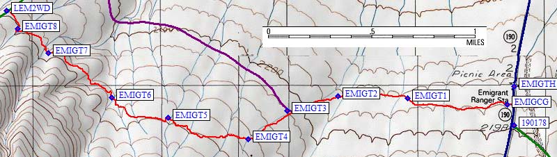
See the trailhead page for directions to the former Emigrant Ranger Station, and details of a 2-3 mile cross-country traverse to the Lemoigne Canyon 4WD road. I walked but you can drive around if you want! Slightly uphill from the Emigrant Ranger Station (waypoint EMIGTH), now closed but still with a nice parking lot, shade trees, and a working water spigot, there is a free bare-bones campground. In the middle of the campground (waypoint EMIGCG) I found an unmarked use trail leading west across a volcanic talus field. The washes I went through didn't quite match up with those shown on USGS maps, but the red line on the topo above is an actual GPS track log with waypoints in the washes
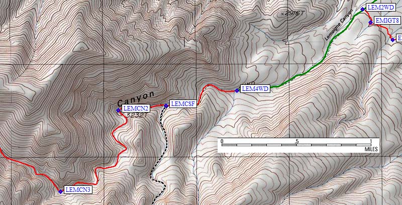
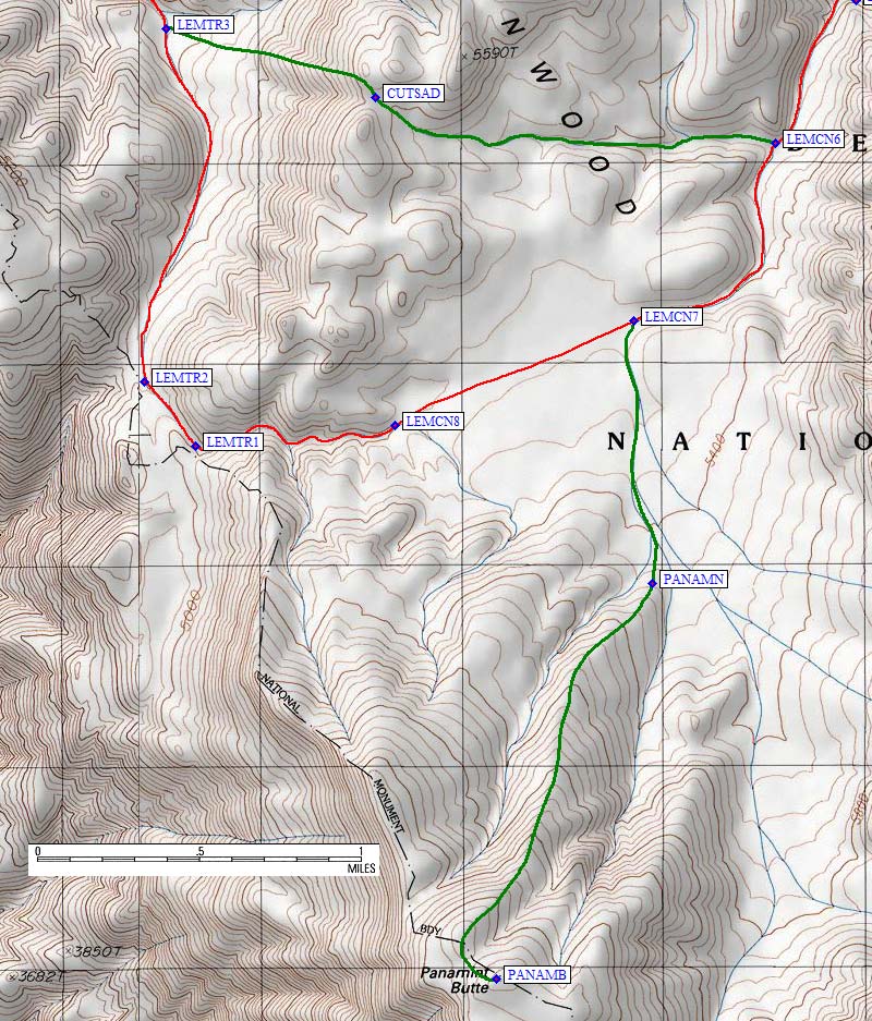
I reached the Lemoigne Canyon 4WD trailhead in about two hours (waypoint LEM4WD). Above the wooden barrier at the current end of the road the drainage narrows into a true slot canyon but the footing is never tricky even with a full pack. If you want to explore the old Lamoigne [sic] Mine, turn left (south) to enter South Fork of Lemoigne Canyon (waypoint LEMCSF) half a mile from LEM4WD. Otherwise, keep straight (west) in the brown gravel wash to continue toward the peaks. I hiked about 3 hours, covering 5 miles, and camped in a wide spot at about 3400'. I carried enough water for the evening and the next morning, planning to melt snow before climbing Panamint Butte.
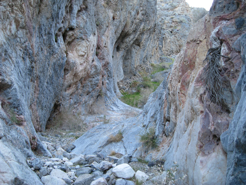
Slot Canyon
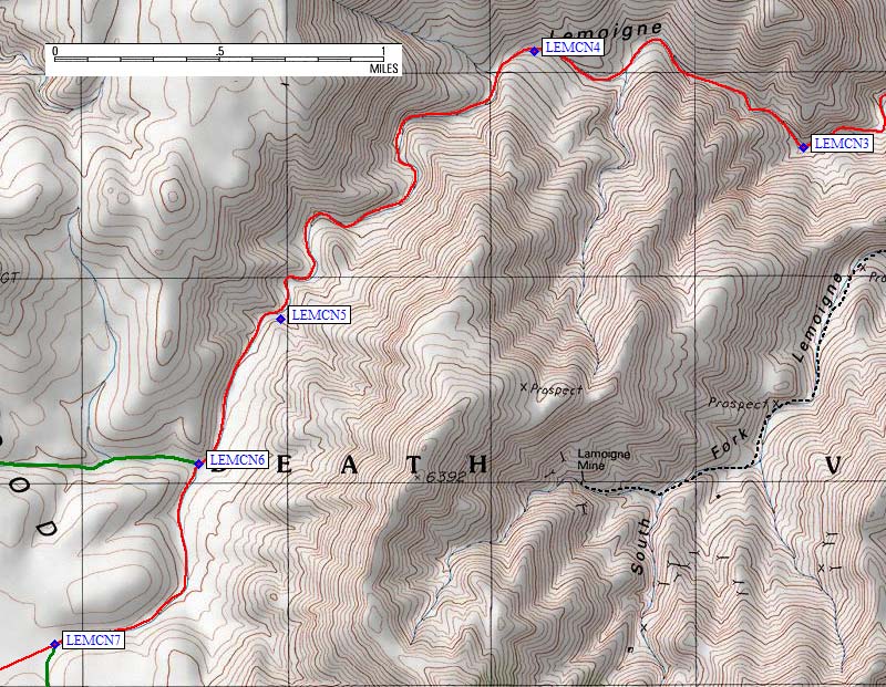
The cayon turns west again, opens up, and becomes far less dramatic. I stayed in what was clearly the main drainage, which bends southwest at LEMCN4: do NOT take south fork before LEMCN4, do not take west fork after LEMCN4, DO keep track of where you are and the right wash will be obvious.
At LEMCN6, due west of Point 6392, a sandy side canyon goes west. I returned this way, cutting off a lot of walking without much gain. My route to Panamint stayed in the main rocky wash going south, where the walking was easy and the temperatures were comfortable. As I climbed toward the Cottonwood Mountains "crest", the wash became vague and almost flat. At LEMCN7 there is a wash going south just before the high point. Here I switched to a day pack and left for the peak about 3 hours into my day.
I followed the wash south three quarters of a mile, then climbed the ridge that leads to the northwest ridge of Panamint Butte (PANAMN) and a bit of low brush over to the summit (PANAMB). It was 2.3 miles and 1.3k from my pack to the peak, with no surprises except Verizon cell service on top! Towne Point should really be on The List, rather than this one, since it's higher and nearby. This peak is BORING. But it looks nice from Hwy 190 so I'm guessing that's the reason we all climb it. I spent an hour relaxing, checking voice mail and returning messages, and trying to figure out which lump on the skyline was Canyon Point. I got back to my pack 6 hours into the day. Water bottles I had stuffed with snow quickly melted into water as the day got warmer.
Continuing west, the broad saddle turns back into a wash. I headed downhill on what was soon to be an old roadbed. It was easy to follow the track downhill as the drainage bends north, but I made a mental note that going uphill I'd have to watch for turns east at LEMTR2 and LEMTR1. I also checked out the option of shortcutting this part of the trip on my return, and it turns out LEMTR3 is the west end of a great shortcut back into Lemoigne Canyon (coming out at LEMCN6). Below that the canyon narrows, and I occasionally had to scramble over huge boulders.
Waypoints LEMTR4-6 are drainage forks that could be confusing on the way uphill. Don't count on the forks being obvious on the map or on the ground. At LEMTR7 I left the wash to avoid brush, walking around the west side of Cottonwood Springs. The area around the springs is completely overgrown. There is easy access on the north side of the drainage (stay high and drop directly to the springs at COTSPR), or you can drop directly from the bump just south of the spring (look for steep worn paths).
Cottonwood Spring is in there somewhere
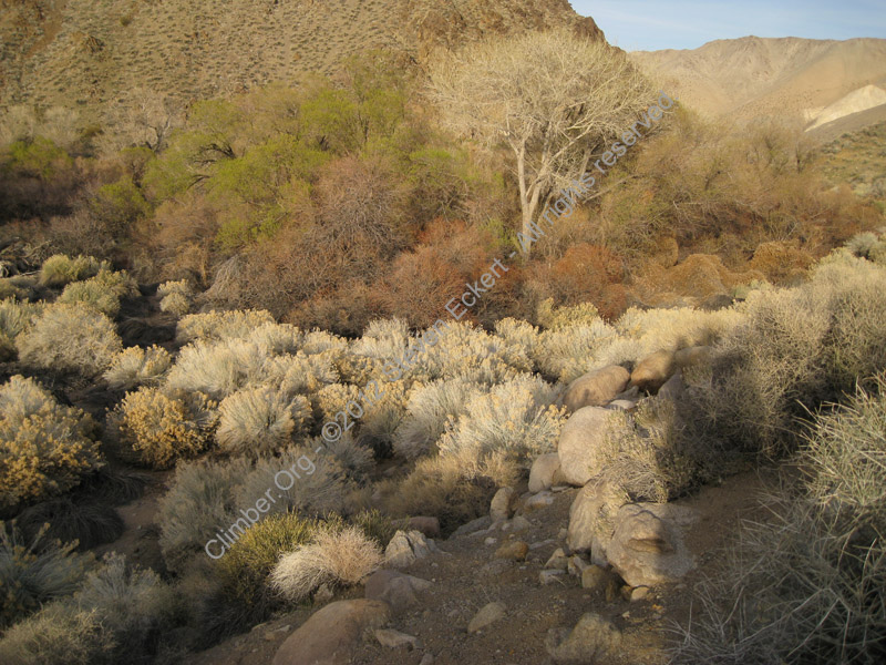
I got to Cottonwood Springs about 9 hours into my day, thrashing around in fallen trees and dead vines because I didn't know exactly where the spring was. The streambed is damp above the spring, where vines abound, but water only runs on the surface below COTSPR. This is right where the canyon narrows sharply and goes around a corner, forcing ground water to the surface. You'll need to filter or boil, there's burro crap in the water! The stream was less than a foot deep and less than two feet wide in Mar 2010. I wonder if it runs in late summer, or how big it is further downstream?
I camped above all the brush and dead plants, in cleaner sand (waypoint COTCMP). There were bees buzzing the buds of a big tree in the evening, owls hooting all night, and no people or animals to disturb me. Very pleasant!
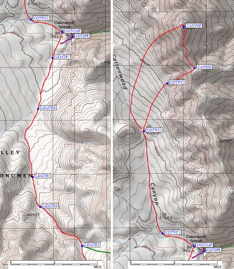
I left camp at 540am, walking up the drainage at the first walkable light, staying right whenever there was a branch. Lots of drainages end at Cottonwood Springs! At COTWC1, Cottonwood Canyon is the smaller sandy wash that bears north, not the larger gravel wash that continues west. I kept going north in the big canyon, ignoring side drainages, until the bump on the left which "pinches" the canyon around 4k (waypoint COTWC2).
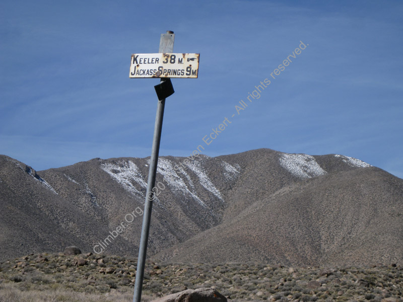
Just north of COTWC1, at the next wash junction, there is an old road sign
I turned uphill here, leaving the drainage for an increasingly steep slope. Near the top was quite steep and a little loose, but not miserable. I reached the ridge at CANSSD, the south saddle of Canyon Point, and followed the simple ridge with good views. There was no sandy slog, which other reports complain about, because I was not on the east side.
On top at two hours from camp, I found a single spiral notebook placed in 1989 containing all the entries for everyone who has climbed from the time this peak was added to the DPS Peaks List... and many of them don't like it! Dale Van Dalsem was here in Feb 1990, summing it up this way: "A tiring slog up a boring sand hill." He took a few minutes longer from the 4WD trailhead in Cottonwood Canyon than I took from Cottonwood Springs, but I didn't slog in any sand. Richard Smith, who noted that he lead the DPS Exploratory in 1988, was somewhat alone in that he really liked the peak. Terry Flood gets top marks for his comment: "My, my, my... what were the blithering nimrods thinking about when they voted this peak on the list, instead of Moriah, Needle Eye, Mormon, etc. Maybe they should be buried here..." (I guess conflict follows lists wherever they go!) There is no really dramatic view of anything from here, and it's NOT higher than anything else in the area. Relative height was easy to tell on this trip, because all the local peaks had dustings of snow EXCEPT this one!
Seeking excitement, I dropped directly down a rib on the west face of the peak, angling south starting at about 4800'. Looking back from the valley, this was the less rocky rib that leads directly to the high point. Everything works on this side, it's just a question of what footing you want and how steep you want it. I got back down to the wash at a sign that points to Keeler and Goldbelt to the north, and 3 miles south to Cottonwood. Apparently Lemoigne and Cottonwood Canyons were tourist routes which needed regular signposts to keep the cars on route?
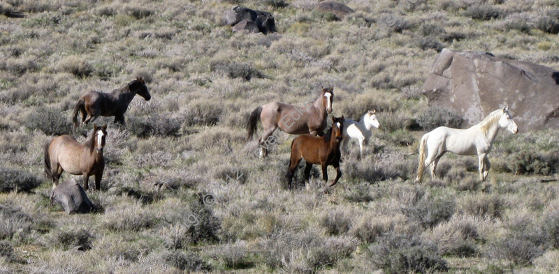
There was a good-size herd of healthy wild horses in the valley,
including a white stallion and a white foal.
I was back to the springs at 10am, only 4 hours into the day and already quite warm. I ate lunch, relaxed, packed, tanked up on as much water as I could hold, worried about my water bladder's leak, and left just before noon. It was now very hot, but I knew there would be snow patches waiting for me near Panamint Butte.
On the way back toward Panamint Butte I left the wash at LEMTR3, as soon as the canyon opened up above the boulders, and went up a rib to an obvious saddle. The footing was good, especially on the west side of the high point, and I shaved about two miles off the return trip in exchange for less than 200' of extra climbing. The snow I had planned to melt was over by Panamint, but on the ridge and out of the heat I realized I had enough water and relaxed before dropping into Lemoigne Canyon. It's easy to navigate down the broad draw as it turns into a sandy wash before LEMCN6.
From the parking area at LEM2WD (right after road climbs out of the wash going downhill) I tried traversing higher across the boulder field. As detailed in the trailhead page, this route (the red GPS track log) is a better way to get between LEM2WD and EMIGTH. Look for a steel signpost with no sign southeast of LEM2WD parking lot: EMIGT8 is that signpost, in a small wash, near a use trail that's worth finding.
Climbing Waypoints - see the
trailhead page
for driving/parking waypoints
![]() Download the Waypoint+ data below as a GPX file for your GPS.
Download the Waypoint+ data below as a GPX file for your GPS.
Datum,North America 1983,GRS 80,0,-1.6E-7,0,0,0
RouteName,1 ,EMIGRANT TRAVERSE
RoutePoint,D,EMIGTH, 36.4978100061,-117.2268600464,01/30/2010,17:22:45,EMIGRANT RANGER STA 2100
RoutePoint,D,EMIGCG, 36.4965121746,-117.2274920940,01/26/2012,08:55:17,CAMPGROUND NEAR OLD STATION
RoutePoint,D,EMIGT1, 36.4969500303,-117.2361700535,01/06/2007,17:33:04,TRAVERSE SMALL WASH
RoutePoint,D,EMIGT2, 36.4971100092,-117.2422300577,01/06/2007,17:33:04,ENTER LARGE WASH
RoutePoint,D,EMIGT3, 36.4960600138,-117.2466200590,01/06/2007,17:33:04,STAY IN WASH
RoutePoint,D,EMIGT4, 36.4940899611,-117.2500300407,01/26/2012,20:12:39,LEAVE WASH TO TRAVERSE
RoutePoint,D,EMIGT5, 36.4955699444,-117.2569899559,01/06/2007,17:33:04,BREAK IN CLIFFS
RoutePoint,D,EMIGT6, 36.4970099926,-117.2618600130,01/06/2007,17:33:04,TRAIL FROM HERE TO LAMOIGNE
RoutePoint,D,EMIGT7, 36.5001599789,-117.2673699856,01/26/2012,20:10:08,LAST LARGE WASH
RoutePoint,D,EMIGT8, 36.5018399954,-117.2700599432,01/06/2007,17:33:04,STEEL POST AND TRAIL
RoutePoint,D,LEM2WD, 36.5031399727,-117.2710299492,01/06/2007,17:33:04,PARK BEFORE ROAD ENTERS WASH
RouteName,2 ,LEMOIGNE CANYON
RoutePoint,D,LEMJCT, 36.5384299755,-117.2142000198,01/30/2010,17:23:14,LEMOIGNE CYN 4WD RD JCT HWY 178
RoutePoint,D,LEMCN1, 36.5338399410,-117.2364200354,03/08/2010,18:29:42,4WD APPROACH
RoutePoint,D,LEM2WD, 36.5031399727,-117.2710299492,01/06/2007,17:33:04,PARK BEFORE ROAD ENTERS WASH
RoutePoint,D,LEM4WD, 36.4952199459,-117.2861499786,03/06/2010,01:07:31,LEMOIGNE CYN 4WD TH 2800
RoutePoint,D,LEMCSF, 36.4937105179,-117.2947204113,01/26/2012,20:58:57,SOUTH FORK JCT
RoutePoint,D,LEMCN2, 36.4932858944,-117.3004555702,01/30/2010,17:24:26,
RoutePoint,D,LEMCN3, 36.4853999615,-117.3073999882,01/30/2010,17:24:38,
RoutePoint,D,LEMCN4, 36.4896500111,-117.3221399784,01/30/2010,17:24:59,
RoutePoint,D,LEMCN5, 36.4777799845,-117.3360400200,01/30/2010,17:25:10,
RoutePoint,D,LEMCN6, 36.4714200497,-117.3405200243,01/30/2010,17:25:24,
RoutePoint,D,LEMCN7, 36.4634100199,-117.3483699560,01/30/2010,17:25:32,
RoutePoint,D,LEMCN8, 36.4587399960,-117.3616000414,01/30/2010,17:29:11,WASH TO COTTONWOOD SPR
RoutePoint,D,CUTSAD, 36.4734300375,-117.3626899719,01/27/2012,01:05:35,SHORTCUT SADDLE
RouteName,3 ,PANAMINT BUTTE
RoutePoint,D,LEMCN7, 36.4634100199,-117.3483699560,01/30/2010,17:25:32,
RoutePoint,D,PANAMN, 36.4516299963,-117.3473099470,01/06/2007,17:33:04,PANAMINT BUTTE NORTH RIDGE
RoutePoint,D,PANAMB, 36.4339100122,-117.3560099602,01/26/2008,10:29:40,2_5 PANAMINT BUTTE 6584
RouteName,4 ,COTTONWOOD TRAVERSE
RoutePoint,D,CUTSAD, 36.4734300375,-117.3626899719,01/27/2012,01:05:35,SHORTCUT SADDLE
RoutePoint,D,LEMTR1, 36.4578299522,-117.3726899624,01/26/2012,23:15:41,WASH TO LEMOIGNE CYN
RoutePoint,D,LEMTR2, 36.4606699944,-117.3755300045,01/30/2010,17:28:51,STAY LEFT GOING UPHILL
RoutePoint,D,LEMTR3, 36.4765472412,-117.3743611574,01/30/2010,17:28:38,SHORTCUT TO LEMOIGNE CYN
RoutePoint,D,LEMTR4, 36.4830700159,-117.3829900026,01/30/2010,17:28:29,STAY LEFT GOING UPHILL
RoutePoint,D,LEMTR5, 36.4880399704,-117.3845499754,01/30/2010,17:27:45,STAY STRAIGHT GOING UPHILL
RoutePoint,D,LEMTR6, 36.4994299412,-117.3834600449,01/26/2012,23:45:38,STAY STAIGHT GOING UPHILL
RoutePoint,D,LEMTR7, 36.5079799891,-117.3804500103,01/06/2007,17:33:04,LEAVE WASH GOING DOWNHILL
RoutePoint,D,COTCMP, 36.5123200417,-117.3784699440,01/06/2007,17:33:04,COTTONWOOD SPR CAMPSITE 3600
RoutePoint,D,COTSPR, 36.5114799738,-117.3763400316,01/06/2007,17:33:04,COTTONWOOD SPRINGS 3600
RouteName,5 ,CANYON POINT WEST
RoutePoint,D,COTCMP, 36.5123200417,-117.3784699440,01/06/2007,17:33:04,COTTONWOOD SPR CAMPSITE 3600
RoutePoint,D,COTWC1, 36.5144100189,-117.3849400282,01/06/2007,17:33:04,COTTONWOOD CYN IS SMALLER WASH
RoutePoint,D,COTWC2, 36.5315099955,-117.3887799978,01/06/2007,17:33:04,HEAD UPHILL AT BUMP
RoutePoint,D,COTWC3, 36.5394999981,-117.3839999437,01/06/2007,17:33:04,
RoutePoint,D,CANSSD, 36.5420700312,-117.3782999516,01/29/2010,23:32:22,SADDLE S OF CANYON PT 5300
RoutePoint,D,CANYOP, 36.5489599705,-117.3805600405,01/26/2008,10:29:40,2_22 CANYON PT 5890