Northern Panamint Range
(Canyon Point, Panamint Butte)
(Tucki Mtn, Pinto Peak, Towne Point)
Revised March 2012 - please send updates to the webmaster
The Panamint Range forms the western side of Death Valley. In the north are Dry and Tin, near Towne Pass are Cayont Point and Panamint Butte, the high point of the range is Telescope Peak (rising over 11000' from below sea level in Death Valley), and the southern end of the range contains two pairs of very different peaks. Porter and Sentinel are over 9k (a real snow climb in the winter) between Pleasant and Surprise Canyons, while Manly and Needle are near Mengel Pass (a serious 4WD road from the west and a long drive from the east).
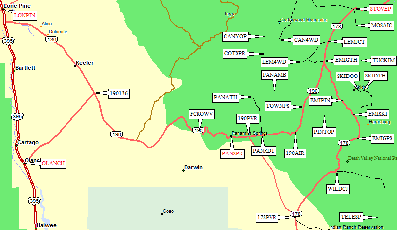
The trailheads below are west of Stovepipe Wells (waypoint STOVEP), in Death Valley. To get to any of them, you need to be on Hwy 190, well east of Olancha (waypoint OLANCH). See the Southern Panamint trailhead page for an optional approach up Hwy 178 through Ridgecrest and Trona (to waypoint 178PVR). On your way, stop at the Father Crowley Viewpoint (waypoint FCROWV) to take in the long views of Death Valley, gas up with expensive fuel at Panamint Springs (waypoint PANSPR), or if you have your own plane let me know if you can land at the local airstrip (waypoint 190AIR).
Area Map: see below for detailed maps of the trailheads:
Panamint Butte, Pinto Peak, Lemoigne Canyon, Cottonwood Canyon, Mosaic Canyon,
Emigrant Pass, and Skidoo.
NOTE: Towne Pass can also be used as a trailhead for Towne Point and Panamint Butte.
Eastern drainage approach, from Emigrant Canyon via Burns Spring:
Southeastern ridge approach, from Emigrant Pass:
Western face approach, from Towne Pass:
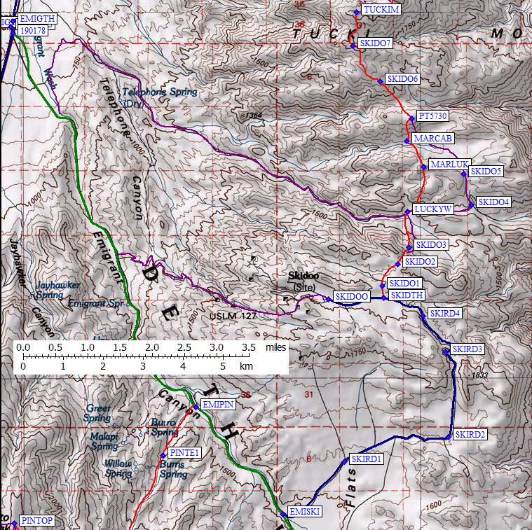
There are several 4WD approaches to the south side of Tucki, but the road to
Skidoo is suitable for all vehicles and it's only a little bit more walking.
This entire area is "Day Use Only" as per a sign at
the pavement, but the gravel is smooth and flat near the trailhead.
Near the Emigrant Ranger Station trailhead (waypoint EMIGTH)
Hwy 178 intersects Hwy 190 (waypoint 190178).
Drive 9.4 miles south up Emigrant Canyon on the well-paved Hwy 178,
or drive 4.1 miles north from Emigrant Pass (waypoint EMIGPS), then
turn east at the well-marked Skidoo Road sign.
Follow the obvious road 6.2 miles to a hard-to-spot Wilderness Area sign
on the north side of the road. This overgrown and closed 4WD route is
the trailhead (waypoint SKIDTH), but there is no parking at all. Put two wheels up
on the berm and hope for the best, drive over some bushes and park on the old
road before you reach the closure, or drive 0.9 miles further and park near the
turnaround loop and historic sign for the old Skidoo site (waypoint SKIDOO).
The route goes over a low saddle into Lucky Wash, then around or over another
ridge to Martin Crossing, and finally up to Tucki. It might be possible to
drive to Martin or Lucky, so let me know if you've done that.
It's a reasonable one-way hike from Skidoo to Mosaic Canyon.
Pinto Peak - see this 2012 trip report
Below are approaches from the west (Towne Pass), the east (Burns Spring) and the southeast (Emigrant Pass).
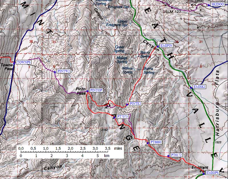
Near the Emigrant Ranger Station trailhead (waypoint EMIGTH)
Hwy 178 intersects Hwy 190 (waypoint 190178).
Drive 7.1 miles south up Emigrant Canyon on the well-paved Hwy 178,
or drive 6.4 miles north from Emigrant Pass (waypoint EMIGPS),
and see if you can find the mound of dirt and wilderness stake (waypoint EMIPIN)
that marks the entrance to an unnamed drainage leading to Burns Spring.
A GPS is highly recommended, because the road is unmarked and overgrown,
and there's only a small pullout for 2 or 3 vehicles. Hike southwest up the drainage
and turn east over several easy ridges to the summit. This is the most scenic approach,
including mine ruins and some nice desert trees. If you want a longer day,
exit via Emigrant Pass and walk or hitch a ride back to your car.
Drive 13.5 miles south on Hwy 178 from where it intersects Hwy 190 (waypoint 190178)
near the now-closed Emigrant Ranger Station (waypoint EMIGTH) to the obvious saddle
(waypoint EMIGPS) where Hwy 178 drops 7.3 miles to Wildrose Canyon (waypoint WILDCJ).
There is lots of parking at the pass, but no big sign. A road heading west has a
Wilderness Area sign, but that's NOT the road to Pinto Peak. Instead, head directly
north up onto the ridge where you'll pick up an old 4WD road that goes all the
way to the summit of Pinto Peak. This is the longest and the easiest approach.
From the Panamint Valley Road intersection (waypoint 190PVR), drive about 9 miles east on
Hwy 190 to Towne Pass (waypoint TOWNPS). This broad, uninteresting pass has a large
parking area on the west side of the highway, from where you can make your way north of
some obvious cliffs to the gentle summit of to Pinto Peak. This is the only route of
the three that I have not personally climbed, but others have. Please let me know if my
waypoints are about right! This is the shortest approach, with the least gain and the least scenery.
Tucki from Skidoo - see this 2012 trip report
|
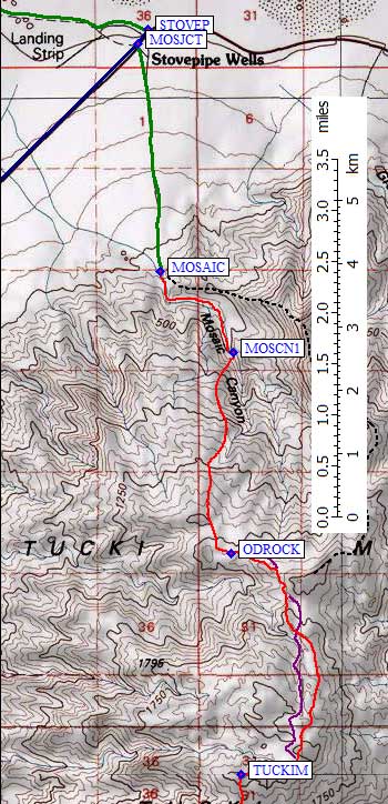
Drive a tenth of a mile west from Stovepipe Wells, and turn south at the sign for
Mosaic Canyon. This sign is not obvious when driving east, so turn around if you
get to Stovepipe Wells (where you can buy regular grade gas only - for premium you
have to go to Furnace Creek).
The bumpy rocky dirt road goes 2.3 miles south and ends at a parking lot. This area is day use only, but no one seemed to bother a car left there before dawn and picked up after dark in 2012. I did get a visit from the ranger when cleaning up and changing clothes after dark... he saw my lights and drove up to see what I was doing. Scores of tourists will be in Mosaic Canyon all day every day, but there's an exit from the canyon about a mile in. Just before the first waterfall look for ducks on the west side (waypoint MOSCN1) and climb an obvious use trail. When the use trail levels and drops back into the canyon above the waterfall, continue up cross-country for Tucki. It's a reasonable one-way hike from Mosaic Canyon to Skidoo. |
|
NOTE: Towne Pass can also be used as a trailhead for Pinto Peak.
4WD Approach to Panamint Butte from Panamint Valley:
Passenger Car Approach to Panamint Butte via Towne Point from Towne Pass:
See this 2010 trip report
for waypoints and details of Lemoigne Canyon and the backpack to Cottonwood Springs.
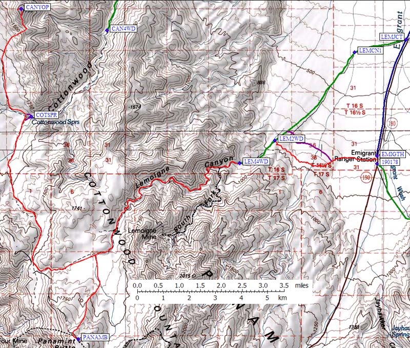
The former Emigrant Ranger Station (waypoint EMIGTH) is on Hwy 190, 9.5 miles southwest
from Stovepipe Wells (waypoint STOVEP), or 19 miles northeast from the Panamint Valley Road
intersection (waypoint 190PVR). Here you will find free parking, free camping, and
even a working water spigot. Since all the roads to here are paved, you can park
any vehicle here and walk 2.5 miles cross-country to the Lemoigne Canyon 4WD road.
It cuts some mileage off walking the road for 4.1 miles, but it's tougher walking.
See the second map below for lots more details!
If you have a 4WD vehicle (or perhaps a high-clearance 2WD vehicle - I haven't
driven this road so I'm not sure) you can leave Hwy 190 at LEMJCT, 3.5 miles
northeast of the old Ranger Station or 6 miles southwest of Stovepipe Wells.
Follow the green line on the map below 4.1 miles to the large parking area
at LEM2WD. This is a good place for 2WD vehicles to stop! Below this the road
looked like 2WD high clearance, but above this parking area the road goes down
to the streambed of Lemoigne Canyon. In the streambed the road turns into
sandy gravel and rocks have been stacked to drive over obstacles.
A wooden barrier marks the end of the 4WD road at a streambed fork (LEM4WD, 2800').
Stay right (west) in the gray gravel wash and follow the red line up Lemoigne Canyon
to a broad saddle where you can climb Panamint Butte (waypoint PANAMB) to the south
or drop down to Cottonwood Springs to climb the west face of Canyon Peak (waypoint CANYOP).
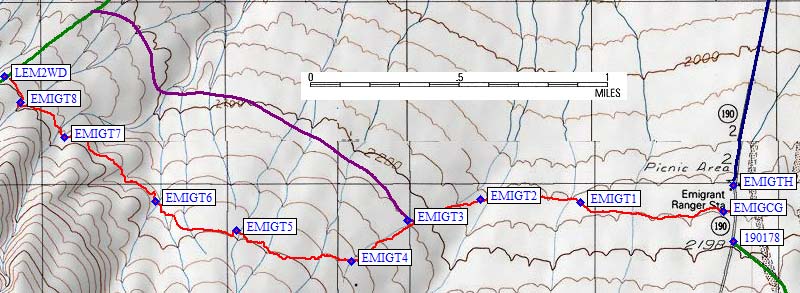
I've walked the red and purple lines between EMIGTH and LEM2WD, and the red line is an
actual GPS track log of what I think is the best route. A use trail leaves from
the campground (waypoint EMIGCG) and is worth finding and following. I turned up
a wash at waypoint EMIGT2, which I followed to EMIGT4 before striking out cross
country. The lower traverse (purple line) deals with more boulders and sharper
erosion gullies. The biggest obstacle is a steep-sided wash, which I picked my
way across at EMIGT5. Drop to EMIGT6 and traverse to the road on a use trail. On the
way out, look near the parking area (LEM2WD) for a steel post (waypoint EMIGT8)
and pick up the use trail there.
If you want to drive more than you climb, this is the route for you!
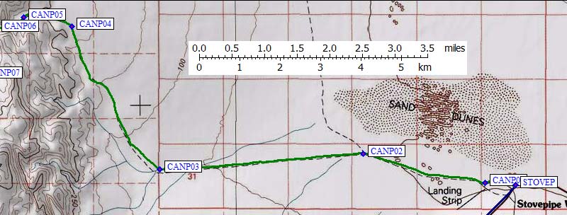
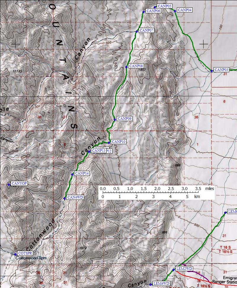
This 4WD road starts at Stovepipe Wells (waypoint STOVEP), and the first section is often muddy in the spring:
Refer to the DPS Guide for details of the road once it enters the canyon. Rangers tell me
vehicles break in that canyon, but that may just be exaggeration! Once you get to the end
of the road (waypoint CAN4WD) it's supposed to be "a sandy slog up a boring sand hill" according to one well-known climber (not me). I've only climbed the other side, from Cottonwood Springs, so I'm not sure.
Useful Links:
Panamint Butte from Panamint Valley or from Towne Pass
Towne Point from Towne Pass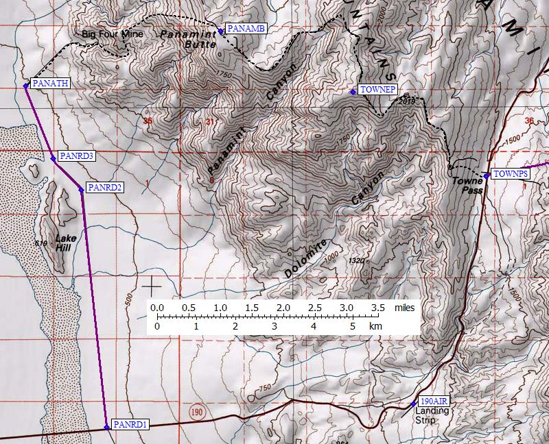
Panamint Butte can be combined with Canyon Point as a backpack from Lemoigne Canyon.
From the Panamint Valley Road intersection (waypoint 190PVR), drive 2 miles east on
Hwy 190 to an unmarked dirt road (waypoint PANRD1). This road is right where a yellow
warning sign suggests turning off your air conditioning for the climb to Towne Pass
(waypoint TOWNPS). Turn north at waypoint PANRD1, and continue 5.7 miles until the
road ends at the 4WD trailhead (PANATH). I have not driven this road myself, so I'm
not sure exactly where it ends or whether 4WD is required. There are trip reports
indicating people have driving most or all of the way to the Big Four Mine, but
I don't think that's legal.
From the Panamint Valley Road intersection (waypoint 190PVR), drive about 9 miles east on
Hwy 190 to Towne Pass (waypoint TOWNPS). This broad, uninteresting pass has a large
parking area on the west side of the highway, from where you can make your way onto
the ridge leading to Towne Point. The DPS has Panamint Butte on their list, but does
not have the (higher and more interesting) Towne Point on the list. Go figure! Climbing
Panamint Butte from Towne Pass involves much up-and-down along the ridge, climbing
the higher Towne Point in both directions.
See this 2012 trip report for Towne Point details.
Lemoigne Canyon - 2WD or 4WD access to Panamint Butte and Canyon Point
Cottonwood Canyon - tough 4WD access to Canyon Point
If you prefer backpacking to a desert spring, see Lemoigne Canyon.