Once upon a time there was a darned fool named Bob Pease who decided that the next time he went to Japan, he wanted to try to climb Fuji-san.... (It is more correctly called that, than Fuji-yama; but this "san" is not the same "san" as in addressing an honored person or friend.)
When I was invited to Japan to lecture at a Nikkei Business Publications Conference in July, I started to do my research. And to do enough exercise so my legs would not give out too quickly. At the end, I was climbing 30 to 60 flights of stairs, every day, at the high-rise hotels.
Mr. Sunohara (formerly of NSC), told me several web-sites about climbing Mt. Fuji. I saw a good write-up in United Airlines' HEMISPHERES Magazine, May 1999, and they recomended several other web- sites. See at end. I got some advice about all the insanity involved, from Mark Levi. He made it seem plausible despite the crowds, and the crush, and the hiking around in the dark.
Mrs. Tomoko Mizushima, the wife of my old-time friend John Mizushima from Takachiho Koheki, also gave some advice. She has climbed the 10 highest mountains in Japan, and she said she would be happy to recommend several other nice hikes that are much more pretty, green, and scenic. But, she observed, of course I was going to be climbing Fuji-San - because it was there - right? I replied that of course she was quite right. That's the way I am - and she could tell. She understands many men, quite well!! But, NEXT time I will ask for her recommendations for nice hiking. Fuji-san was not just a pleasant stroll, unless you are a very strong hiker. Even then, you can never be sure how the high altitude will hit you. But it was very impressive, as expected, and a great experience.
I got a little advice from Ichirou Anzai at NSJ. Then I was intro- duced to Douglas Waggy, also in National's Tokyo Office. He's climbed Mt. Fuji several times. He gave me several chunks of advice, and answered my questions, until I was comfortable that I could climb it safely, if I did not get any bad health, bad weather, or bad luck.
Then Doug decided he could come along and climb with me. We planned a departure from Shinjuku station, the busy and popular train station on the western edge of Tokyo, about 7:30 PM on July 16. I could have started earlier than that, except for two items: Waggy-san was not able to get out of work any earlier than that, and there were no busses between 8:30 AM and 7:30 PM. A 2 PM bus would have suited me fine, but there were none.
(If you can understand the Japanese language well, you could easily take some trains to the desired town at the foot of Fuji, and get a bus or taxi up to the desired trailhead. You could do this at almost any reasonable time of day, or time of year.)
So I had a good supper at 6:30 PM and bought a couple beers (to help keep me hydrated and also to get me sleepy on the bus), and Doug and I started out on the west-bound express bus at 7:30. Price in 1999 was Y2600, about $21, not bad.
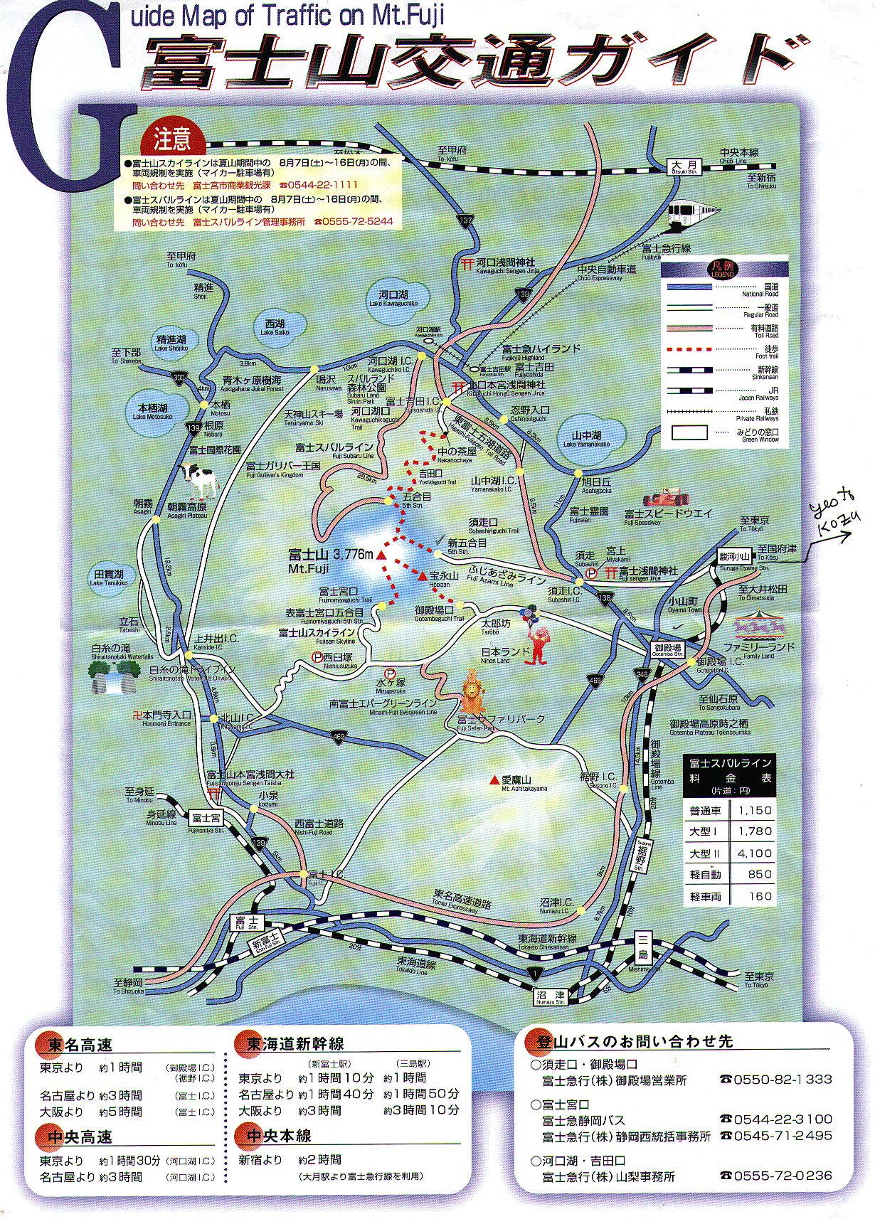
NOTE: the comprehensive LIST and posted CHART and MAP of all bus stops in the Shinjuku station area covers a large number of local and long-run busses, and in 1999, down near the bottom, is listed bus stop #50, which is the Keio Express Bus Office. This is clearly shown on maps. They have busses to cities such as Nagoya and Osaka - and to Fuji Go-Ko (Fifth station). The bus may actually leave at the nearby bus stop # 26, so you must be prepared to move over to a new place. Don't be surprised by anything!
The guide books said that it would take 2-1/2 hours for the bus to get up there. I was sure it would take at least that long, but traffic was light. At 9:28 PM we stopped. Was this some kind of intermediate stop?? Not so. Time to start walking.
I bought a handsome octagonal walking stave (with noisy jingle bells on top, which I pulled off carefully, PRONTO) for $8, because I had mis-placed my jointed walking stick. I could have paid 200 yen to get this stick branded at EACH station, but I refused to pay. I did get it branded for 300 yen, at the top. Hey, I couldn't have gotten a brand on my good METAL walking stick! This walking stick was a 1-inch octagon, a full 59 inches tall. I usually set my hiking staff at 51 inches. This one was ok for downhill, but too tall for up-hill. Don't let the guy sell you one longer than you want, just because it is a bargain!
We started off on a 1% downgrade. Soon we could see most of the road in the dark. It took only a BIT of peripheral light from any of the hikers' flashlights, to see how to go, as the road was very smooth gravel. Shortly we started up a grade. Though the night air was around 12 degrees C, we started at a nice comfortable pace. Didn't get cold, even in shirt-sleeves. The pace gradually got a bit steeper, then rockier. We passed the sixth station which just had some safety advice, brochures. Then it began to get steeper and rockier and rougher. It began to get hard to pick your steps. If it were in daylight, it would not be a big deal; you could easily see a good place to step, a good route. But at night, it was definitely challenging. I found it hard to maintain my balance on some of the difficult steps. Normally I never have any trouble with balance, but I began to wobble and lurch between steps, just occasionally. I think it was just another aspect of trying to hike by flashlight. About every 2/3 mile, when there was a hut, they had a big floodlight, and then we could easily see where to walk. (Floodlights and coin-operated vending machines were powered by gasoline generator sets at each station.)
Fortunately, after about half a mile of rough, rocky, steep steps, it became less rough, and reverted to an ordinary trail. It was mostly wide enough for two columns of people to walk side-by-side - basically, two lines of slow traffic. Often one line would stop, and we tried to stay in the other lane - the passing lane - because the slow lane just had too many stops. But the slow lane had better packed dirt to hike on - less rocks and scree to trip over.
This continued most of the way up, until daybreak. Namely, at least half the time, from the 6th station onward, there were crowds, small mobs, and minor delays. Not a disaster, but a definite slow-down.
About 1 AM, we got hit by a little rain. Fortunately, after I got my raincoat on, the rain stopped. An hour later, it rained for another minute. And quit! We were really lucky with the weather.
The trail was just steep enough, and the pace JUST slow enough, we were able to keep warm, and not get too tired. (If you went up in the daytime, it would definitely be warm hiking!)
Just before daybreak, you could see the sky starting to lighten up in the north, then in the northeast. (For the whole night, we could see the lights of towns in the valleys below us; and the dim glow of clouds 40 miles to the northeast, lit up by the distant lights of Tokyo and Yokohama. But not lit up quite enough for hiking without a light.) IF it were perfectly clear, you could probably see the skyscrapers of Tokyo, but we don't expect that very often in the summer.
The books all say that the busy, popular climbing season is in July and August - especially in the vacation time of August - but they neglect to mention that this is also the rainy season. If you got started up and got a LOT of rain, that would not be much fun. I don't know your opinions on hiking in rain, but I don't find it fun at all. Hiking up Fuji in the rain - well - you know what they say about owning a yacht: like standing in a cold shower, tearing up thousand-dollar bills... Same darned kind of no-fun. If you happened to be in Japan in June, you might avoid the chances of rain and most of the crowds. Or in September. But then the huts would not be open. Still, for a long day hike, (well, NIGHT-hike) it is NOT that big a deal to carry your water and munchies.
I carried up a LOT of water. I was well hydrated with beer and coffee and noodle soup, when I started up. I was carrying 5 liters of water, plus a can of beer plus a can of iced coffee. I drank about half of that, and kept WELL hydrated; even though I kept getting thirsty, I just drank away - to lighten my load. I carried about half that water all the way up and down and back to Tokyo. It's nice to have a big safety factor. I could have bought water or juice or similar, at any of the huts. About Y300 or $2.50 for 10 ounces. Pretty steep, but not any surprise. But I didn't buy any - I had plenty.
I went to the toilet at the last bus stop, at 9:50 PM. And at the top - and then down at the train station at 4 PM. The air was drying enough, I never did have to go to the john more than that. Despite drinking at least 3 liters. So, as on any tall hill, keep pouring that water in. Keep well hydrated. Meanwhile, don't leave all your change behind - bring several 100-yen coins to make a contribution at the toilets. Bring enough money for food or drink in case of delays.
Every time we came to a hut, there was typically a crowd of 100 people. Some were just hanging around; some were ducking inside for shelter or food or rest. We tried to go to the upper end of the crowd, above the hut, and get a minute or two of rest, and drink some water.
Then I'd propose to my climbing-mate, "Do you want to start up in 4 minutes or 2?" I think this is a good way for a small group to go up a hill: as soon as you stop, try to agree on how long you will rest and stay before starting. If one guy proposes 2 minutes and the other guy says, "I need 10 minutes", you can sense each other's condition. Doug and I were in pretty good synch. Even though some strong hikers would go hiking past us, we knew were doing OK, and if we kept a nice slow pace, we would get up there. Hurrying is definitely a bad idea. This is another place where an experienced hiker can use good judgement to not go too fast.
I never did get seriously out of breath. My legs never did get extremely tired. That's because I was holding such a slow pace. All the way up. I was working on the classic trade-off of air, legs, and time. If you don't do anything foolish, you will get there.
When we stood at the top end of the crowd at a hut, sometimes we were able to get started a minute before 100 people all started up. That is a lot better than getting started JUST as 100 people are suddenly starting up - or just behind them.
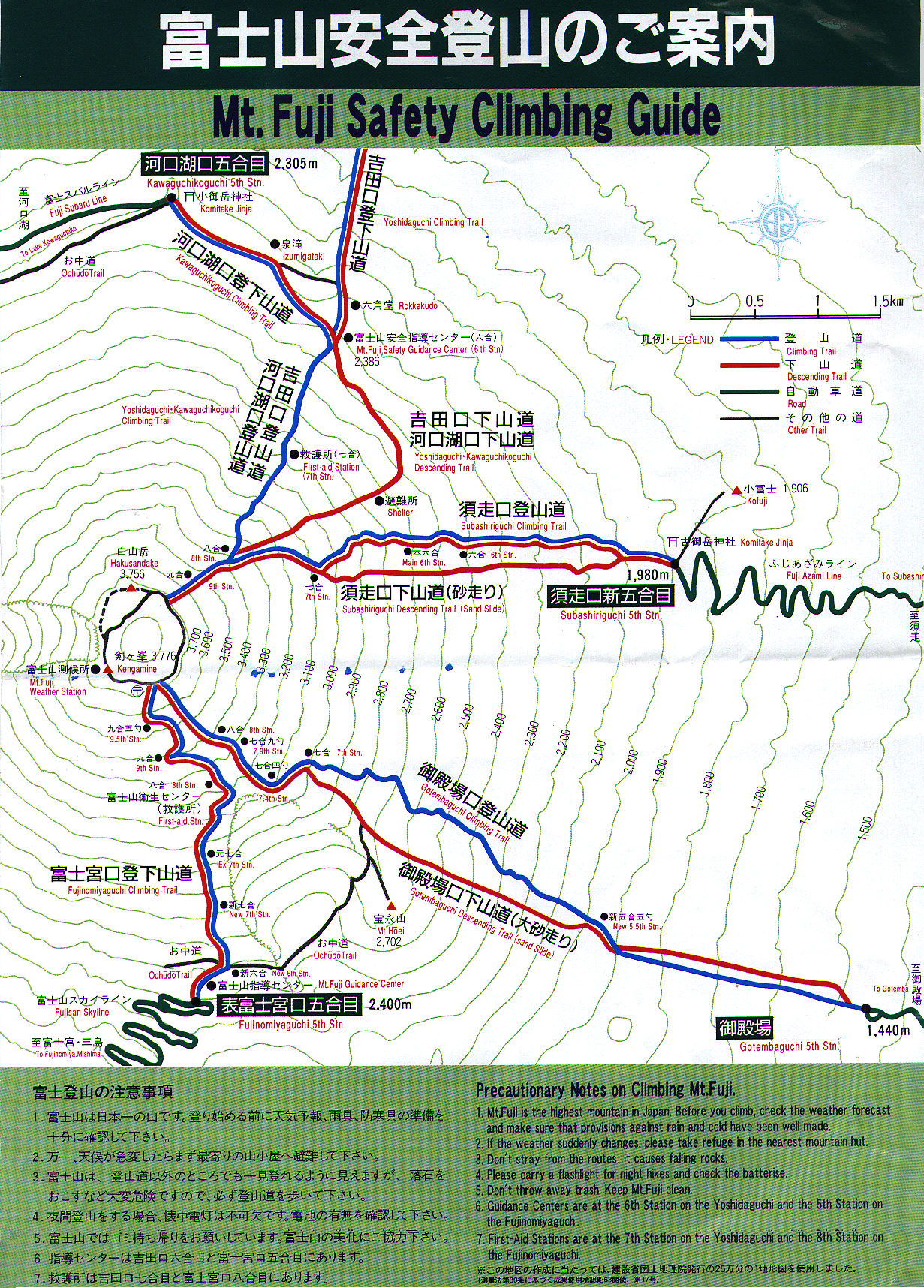
HUTS: The Fifth Station (Go Gome) at Kawaguchikoguchi is a bus-stop with shops and hotels that stay open all the time, in the high season. The sixth station is just a safety check-point with pamphlets in English and Japanese. Not sure about other languages. Here's where it gets complicated: the "seventh stage" consists of about 4 huts, and the eighth stage also about 4. None of them are labelled or signed worth a hoot. Maybe people who can read Japanese well, can tell where they are at. Even Doug Waggy, who can, was a bit confused. Even if we had had a map, it would have been hard to tell where we were, in terms of making progress. A good altimeter would be useful, to tell your progress.
Adding to this is the factor that, after 4 stations at 7 and at 8, there is not any 9th station open. By then we could see the TOP, but it was hard to believe we could see it.
Somewhere around the 9th stage was when the daybreak began. About 3:50 AM. We could see we would not be at the top for sunrise - but, we knew we were not in trouble. We'd get there pretty soon.
For some reason, Doug was getting tired and cold, and his stomach did not feel very happy. We sat down. It was a good time to take pictures for the daybreak. He was getting a bit tired and shivery, and he was not in a mood for eating or drinking, even though eating a bit of high-energy food would probably be good for him. After a few minutes of rest, we got good pictures of us, and of the sunrise. Which was beautiful and GLORIOUS. Very fine sunrise. The sky was pink and orange and red for over an hour.
Then we resumed the ascent. Slowly. (Most people who were ahead of us before daybreak were storming up to the summit, trying to make speed. Most people below us were slow, and pacing themselves.) At sunrise, we were still just 500 feet below the summmit. Nobody who was actually on top could possibly see any better view of the sunrise than we had!
Could we have gotten to the top in time for sunrise? If we had had NO slow-downs due to traffic, possibly. The sunrise was at about 4:30, and we got to the top about 5:00. But it's hard to say - if we had not had so many slow-downs, we mightta gotten MORE tired, and gotten in other kinds of trouble. A really strong and/or lucky hiker can make it up from the 5th station to the top in ~ 6 hours. All the rest of us have to take in the great sunrise from a mere 12,000 feet, or lower, if we do not get a start before 10 PM. I am convinced there were only 1400 people above us at 4:30 AM, and 300 below us. If it were HIGH season (wait 2 or 3 weeks) the numbers could easily DOUBLE. There were at least 15 or 20 busses in the parking lot at the 5th station. A LOT of people. And I think the parking lot was just 1/2 full. Conversely, if you avoided a weekend, traffic might be MUCH lighter - but maybe not in August.
Ascending above 12,000 feet, I saw an old gentleman who was nursing his leg cramps, and his daughter was helping him rub them. I gave him a couple potassium tablets, and I was sure he would feel miraculously better in a few minutes. Potassium gluconate is really good for cramps. If in doubt, take along some potassium pills. I always do.
We eased over the last bit of the hill at 5 AM, through the Tori gates. Not a bad hill. Doug was feeling a bit tired, so we went into one of the huts, and he took a nap, sitting up, and I finished off writing my postcards - about 25. I was torn between trying to stay awake and write, and taking a nap. I think I got 5 minutes of nap. Combined with 5 minutes on the bus, and 15 minutes of nap down near hut 7 on the descent, that was about all the sleep I got. It was enough. (Until we got down to the 5th stage, and had to wait an hour for the bus; and then I got a good nap, almost an hour, lying flat on the parking lot.)
After an hour I tried to find the post-office - it was alleged to be 20 minutes south. (CW around the crater.) Yes, I hiked about 18 minutes south, past the telephone office, to the area of another store/hotel, shrines, and post-office. I mailed my cards in the post-box.
NOW - should I continue around the crater - or go right back? NAW - I'll keep going. I ascended (CW) to the highest point, up by the weather station. Good views into the crater, about 1000 feet deep, with some snow in it. (There had been a few patches of snow on the NE slope, about 12,000 feet.)
Some views over clouds, off to the south and west. Then back to the mini-hotels. Met up with Doug. We agreed it was time to start down. I had a good sun-hat, and put on some sun-screen. I shoulda put on a LOT of sunscreen, as I got a bit of sunburn. The sky, even though overcast, lets through a lot of ultra-violet at those altitudes!
Clothes: I had a wind-parka and a rain-poncho and a inner wooly jacket, and stupid cotton gloves, and I used all these, and when the cool winds blew, above 11,000 feet, they felt good. I had a wooly hat for cold weather, and a sun-hat, and I alternated those. I also had 3 BIG garbage bags, in case we had to hunker down in bad rain, and I had 2 shirts and an extra pair of pants, and socks (which I could use for mittens), and these I did not use. But I had some good safety factors.
I had two good little flashlights, using AA cells. I think I used less than 1/2 of a set of batteries, by using alternately the light of others. Don't bring just 1 flashlight and spare batteries; bring two flashlights, as bulb life is iffy.
NOTE: Unlike any other mountain I have been on - the trails on this hill have different routes for uphill and downhill. So we started down a zig-zag trail of gravel - actually a tractor road, where the cater- pillar tractors bring up supplies, food and water, every day. We started down about 9 AM. The walking was on soft gravel, not hard, but not exactly easy, either. Hey, if you are going to descend 6000 feet, that is a brutal amount, but this was a relatively easy way to do it!
We kept passing some of the huts we had passed on the ascent. They did not bear much resemblance to the confusion we saw on the way up. Weird!
Further down we started down a straight descending trail. The trail to Subashiriguchi. Every step was a nice 6-inch step down plus a 4-inch slide on the gravel. (I read that the Gotemba trail has faster slide trails.) Half an hour on this was making good progress - but quite wearying. And again and again. We had to stop every 10 or 15 minutes to empty gravel out of boots, despite our care. The nap at 10 AM felt good. By noon we were down at an unofficial rest stop, still above the 5th station - maybe station 5-1/2. I drank the beer I'd carried so high and far. Good stuff. Then about 1/2 hour hiking through woods to get to 5th stage.
(Caution, try to avoid bumping into foliage on this stretch, as I got a bit of poison-oak type of allergy from plants I could only have contacted here.) (There were NO plants up above the 6th stage - quite barren...)
After almost 2 hours of wait, we got a 3:00 PM bus ride down from the 5th station at Subashiri, directly down to the town of Gotemba, right to the train station. What was the fee, about $10. The bus driver had a speed limit of 30 km/hr, about 18 mph, all the way down. BORING, to drive for an hour at 18 mph!! (It was tempting to hire a cab, but that might have cost $80.) At Gotemba, the JR (Japanese Rail) ran in two ways. We could have gone down to Numazi, south, along the sea, but decided to take the more direct route east to Tokyo.
We'd just missed an express train to Shinjuku, but we took a local train to Nazu (about $5), and then changed to another train that ran through Yokohama to Tokyo. We arrived at the 5th stage at 1:05 PM, took the 3:00 PM bus down and arrived at Gotemba at 3:55, and took the 4:13 train north. The train ride was pleasant. It was a local train, and had about 24 stops on the way to Tokyo. Still, we got back to Tokyo less than 22 hours after we left.
When we got in there, Doug called his wife to try to find me an inexpensive hotel. Hey: when we started, there was NO WAY to guess when I would be returning. So I could not exactly book a hotel room for my return. I was prepared to get back on Saturday - OR Sunday or Monday. Whenever I got back, I would not complain.
Doug's wife booked me in at the YMCA on Hongo-Dori - not far from Kanda station - quite close to exit B6 from Shin Ochanomizu station - at a very reasonable rate. The room rental was near $70 on weekends, and $90 on weekdays. Nice clean, neat room - even had a small icebox and radio/TV. Good location, barely a block from the Metro. Close to the Transportation Museum and to Akihabara. Just a mile north of Tokyo Station. It was neat and clean, and I'd recommend it to anybody on a budget. The phone number is - (03) 3293-1911.
Would I recommend the Mt. Fuji hike for good hikers? Yes, for any experienced hiker in good shape. If you are not fairly strong or in good shape, you might get tired, have an accident or fall. If you are not experienced, you might also not recognize what is going on. It would help to have a friend to go with. It would be nice, though not essential, to have a friend who can read and speak Japanese. Bring LOTS of water, and a little food. It would help if you can get an encouraging weather report, and/or bring a good full set of foul- weather pants and coat. AND a cover for your knapsack, so it will not get its contents soaked.
Is this an adventure? - yes, a very good one. In the whole "theme park" of Japan, this is one of the great adventures. I'll recommend it to good hikers. I'd even recommend it to my wife - but she would greatly prefer the day-time ascent! (The night-time ascent is often favored, because you get to see a great sunrise from the top; and the hiking at night keeps you warm, yet you avoid hiking in the daytime when it can get quite hot.)
Food: I brought crackers, cheese, sausage, chocolate, nuts, and I ate almost none of that. On the ascent, I just ate a few Kit-Kat sticks, and they really were comfort-food - they made my tummy feel good, and seemed to give me energy. Inspiring, on a cool uphill.. I don't recall eating anything at the summit. But down at the 7th stage, I ate a few more ounces of chocolate. Soul food! I never did get hungry 'til the next morning! Except I did enjoy an ice-cream-cone down at stage 5. But I was glad that I had plenty of food and snacks and munchies, in case of a delay.
Boots: I had a new pair of good heavy hiking boots, but I left them home and took my old worn-out ones. They are very comfortable, and I didn't care if they got ripped up. (They didn't.) I considered wearing light hiking shoes, but they would have been ripped up badly by the rocks and would not have protected my feet so well. I think the heavy boots, despite their weight, are better. You can do what you please - but don't be surprised if the lighter boots give problems on the rough rocks.
Which trail??? Most books say the best ascent for a first-timer is to take the Kawaguchikoguchi Trail. Others say the standard approach is the Yoshidaguchi Trail. Don't be too confused:
If you are ascending on the north side, the express bus will bring you to the trail-head at Kawaguchikoguchi 5th Station, and you start up on the trail of that name. If you start up from the bottom at station 1 (most of us do not) - that is the Yoshidaguchi Trail. These trails join at the 6th station, and become the Yoshidaguchi-Kawaguchikoguchi Trail. Don't be surprised to hear it called by any such name. This trail goes up the Northeast corner, giving great views of sunrises, like a huge theater. This trail from station 5 is "only" about 5 miles, and ascends "only" 5000 feet. If we could do the standard AMC trail time, that would take about 5 hours. We took about 7 hours, which is not bad for hiking above 10,000 feet with no acclimatization and heavy crowds - by flashlight.
Be VERY careful when planning your descent. We took the Subashiriguchi Trail down. It goes due east from the 8th station. This trail stays merged with the Yoshidaguchi-Kawaguchikoguchi Trail down to the 8th station, which in itself is a warren of cross-trails and of at least 4 huts. No, in detail there are about 6 huts: Hakuunso, Gansomuro, Fujisan Hotel, Tomoekan, Munatsukiedoya, and Edoya. These are surely not labelled in English, and probably not clearly labelled in Japanese. But if you know the names of all 6, you can ask, which one is this?. Then you can refer to the map. Our descent was 5900 feet, and took barely 4 hours.
Be sure to get on the trail you want, there. The descending trails will generally NOT be the same trail as the ascending trail. So don't be surprised if they don't look familiar.
We met one unfortunate guy at the foot of the Subashiri trail (down at 1980 meters), whose car was over at the Kawaguchikoguchi trailhead. He had no money with him. His cell phone was back in his car. He did not have much choice but to climb back up to the 8th station at 3250 meters, to get to his car. So that is what he was going to do - climb back up 4000 feet. Pain. One book says there is a traversing trail that goes around the base of the mountain at the 5th- station level. Maybe there is, but it is not marked with signs nor on a map, so don't count on that.
We could have taken the Gotembaguchi trail, which goes down to Gotemba via the southeast angle, starting from near the Telephone building at the south edge of the crater, but we did not. It is alleged to have steep gravel slides for a fast descent. The other trail is the Fujinomiyaguchi Trail, which leaves south from near the Post-Office. There are no trails on the whole western half of the mountain.
(If you are not very well versed in Japanese, the common thread here, "guchi", just means "entrance". The name of the trail is often given without the phrase "Guchi" at the end. Don't be surprised at anything.)
Be sure to get a decent map of the mountain. (I could give you an adequate photocopy.) Many maps that you can buy or scrounge have no contour lines, or are extremely vague. Most are only in Japanese, not labelled in English. The map I have is a folded sheet, double A4 size, about 8" x 12" with a handsome blue-ish color photo on the front, showing a lot of switchbacks. It is labelled "Climbing Mt. Fuji". I got a free copy at the foot of the Subashiri trail. I sure wish I had had it before I started! Inside are maps nicely double-labelled in English and in Kanji:
A map of the whole upper mountain with the 4 major climbing trails; a detail map of the summit loop around the crater; a fine-detail map of the area around the 8th station, so you can go down the correct trail. And a transportation map on the back cover, showing all the roads, trains, and access routes.
References to add: web sites from HEMISPHERES, and from Mr. Sunohara:
Some of these sites have good info in English, and some are mostly in Japanese, but some of the pictures are nice.
There is a good guide-book that I bought at Amazon.com, about $25. It just had 3 pages on Fuji-san, but it had MANY pages on other good Japanese hiking, so for that I'll recommend it for my future hikes. That is, Paul Hunt "Hiking in Japan : An Adventurer's Guide to the Mountain Trails".
In one of the web sites, I read the story of a guy who took 8 hours to get up to within 800 vertical feet from the summit. He gave up and went back. Maybe he was feeling lousy... if you are, that is a wise thing to do. But when we got a few hundred feet from the top, we knew that a slow-but-steady pace would get us to the top. No problem.
Etiquette: There seems to be no special etiquette on the mountain, compared to the rest of Japan. It's bad form to fall down in the dark and bump into people. It's bad form to go out into a passing lane and then stop or slow down, if you have any choice. Most hikers are fairly polite, and wait until their line moves, and do not wedge (excessively) in front of other climbers, in lines. Passing on an alternate path is OK, and maintaining the two lines of ascent seems to work OK. The normal path has the best footing, but the hikers seem to do a lot of stop-and-go. The passing lane is usually rougher footing, but does not do so much stop-and-go. If you are a strong hiker, it goes OK. There is no special greeting between us "pilgrims". "Konbanwa" seems to work OK, at night, or "Ohayo gozaimasu" in the morning. I tried "Namaste", and got nice replies of the same! "Hi" or "hello" is almost universal, especially for greeting westerners. I think about 2% of the hikers were some kind of gringo. About 40% of the climbers were women.
When I came off the mountain, and got on the bus, I felt pretty good. The next day I got up and still felt good. But when I actually started walking around, my legs did feel a little sore. And the NEXT DAY, they STILL felt sore. But not too bad. I did have a little headache on top, but only a very tiny one, not much of a bother. It sorta went away as I descended.
If you have any questions, feel free to ask me. This is intended as a guide for any English-speaking person to figure out what is going on, and solve some of the mysteries of hiking in such a strange yet won- derful place!