Horse Corral Meadow and Marvin Pass
Sunset Meadow and Rowell Meadow
Revised 28 Mar 2012 - please send updates to the webmaster
From the north, follow directions from Fresno to The Wye (then see the text below).
from the south, follow directions from Visalia to Three Rivers (may be closed in winter)
Sunset Meadow appears on the USGS topo map, but not on any road signs! Scott Carpenter writes: It is interesting to note that although the Park service refers to all trails out of Rowell Meadow with a 'Sunset Meadow' suffix, e.g., J.O. Pass (Sunset Meadow) trailhead, or Belle Canyon (Sunset Meadow) trailhead, I could not find the Sunset Meadow name on any sign. The road sign pointing to the dirt road only refers to the Rowell Meadow trailhead, and all signs at the trailhead only refer to Rowell Meadow. The name 'Sunset Meadow' is nowhere to be found.
Here's the eastern portion of the drive, from Hwy 198 to the split between the two trailheads.
Note that StreetAtlas doesn't quite have the roads in the right location on the maps below.
The GPS waypoints match where my car actually was! Connect the trailhead map
to this one by matching up the yellow lines and waypoint ROWLMP (the junction where
the road splits to Rowell Meadow and Marvin Pass trailheads):
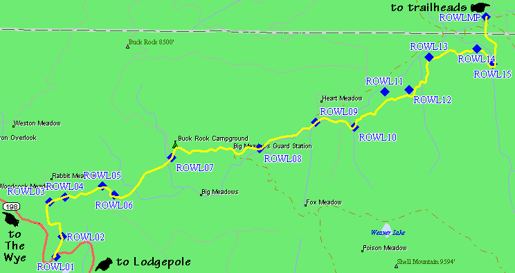
Leaving Hwy 198 (The General's Highway)
There are gates at ROWL02 (very near the highway) and at ROWL09 (after the huge campground section), so I assume the road is only open part of the way part of the year. That assumption is bolstered by the 'Big Meadow Nordic Ski Trail' sign by the gate at waypoint ROWL02. The Big Meadow area would be very gentle ski terrain in the winter!
There are tons of pay campgrounds around ROWL07, and lots of horse people around Big Meadows, and all the roadside spots out along 198 are patrolled by Park Rangers... but if you want to crash for the night, park near waypoint ROWL04 which is NOT in Sequoia National Park - it's National Forest land, meaning you can pretty much camp wherever you want. There are pullouts and 4WD roads in abundance, and you're at about 7500' elevation so you get some acclimatization overnight. This is a good bivy spot even if you're headed to Lodgepole for a permit in the morning, since it's only 1 mile off Hwy 198.
For another free camping option, check out the CHERRY waypoint on the King's Canyon page. (It's a few miles NORTH of The Wye.)
The road is paved to the junction at MARV03, past the split (at ROWLMP) between the Marvin Pass and Rowell Meadow trailheads, but it's winding and takes half an hour to get from 198 to the split. There are LOTS of horse trailers and families camping here, but not much traffic.
The junction at ROWLMP is where you choose between the Marvin Pass trailhead and the Rowell Meadow trailhead. On the trailhead map below, this junction is where the three colored lines meet.
At waypoint ROWLMP, nine miles from Hwy 198, there once was a brown sign telling you about the two trailheads, but as of 2003 the sign was missing. There is now a sign saying 'Horse Corral Pack Station' to the right, which looks like a dirt driveway but is in fact the road to the Rowell Meadow trailhead. The paved road to the left leads to the Marvin Pass trailhead.
The best way to find the junction at ROWLMP is to note that waypoint ROWL15 marks a bridge crossing Rowell Creek in a hairpin turn (a nice picnic or swimming spot on your way out), and ROWLMP is about 0.7 miles north of this crossing.
To reach Marvin Pass, keep left (go straight) at the ROWLMP junction and you will end up at a trailhead about half a mile north of Marvin Pass. (The road signs say nothing about Marvin Pass or a trailhead, but it's there anyway!) If you keep right, you will go past what is called Sunset Meadow on the map to a trailhead half a mile north of Rowell Creek.
Here is a detailed map of the trailhead area, with parking at MARVTH
and ROWLTH. Connect this map to the road map
above by matching up the yellow lines and the waypoint ROWLMP
(the fork where you choose Rowell Meadow or Marvin Pass):
To reach the Marvin Pass trailhead, stay LEFT at waypoint ROWLMP
as described above. Follow GPS route MARVIN PASS TH. The pavement
ends at waypoint MARV03, where there is a left turn to Horse Corral
Meadow (and you stay to the right). Around waypoint MARV05 the
dirt road gets worse but is still OK for passenger cars. The next
two junctions are not marked with any signs at all. Stay right at
both intersections, and you'll soon see the Marvin Pass trailhead
sign at a large parking area (waypoint MARVTH). The road used to
continue beyond this parking lot, but is blocked by a mound of dirt.
There are logging trucks and horse trailers in the area, so don't
get carried away zooming around the corners. The trail heads uphill
to the east from the parking area.
The trailhead for Marvin Pass is at 8400' elevation, but you gain
700' to the pass and then drop 300' to reach Rowell Meadow. There
is no water and no scenery other than tall trees until you reach
Rowell Meadow. The Rowell Meadow trailhead gets you to the same
place with 1000' of gain and no loss - note that the total gain
for a round trip is identical, but Marvin Pass breaks it up a bit.
Marvin Pass is a great way to get to Roaring River (via Sugarloaf)
since there is a couple THOUSAND feet less elevation gain than
Avalanche Pass from Cedar Grove. There is 1000' more gain on
the way OUT than on the way IN, since your car is at 8400 and
Sugarloaf is at 7100', but it's still less gain on the way out
than going back over Avalanche Pass.
To reach the Rowell Meadow trailhead, stay RIGHT at waypoint ROWLMP
as described above. Continue to follow GPS route ROWELL MDW TH
past a pack station until the road ends at a circular parking area with a
fancy pit toilet (waypoint ROWLTH). There was a spigot with fresh water as
of 2003, in contrast with earlier reports, and fire rings by some of the
parking spots. No fees were being collected! The water spigot has a chemical
taste, but isn't marked nonpotable. It appears to come from a nearby well.
The trail does NOT leave from the large information sign near
the large pit toilet! That old roadbed is a dead end. The real
trail leaves from the far end of the parking loop, near the split,
and is marked by a small wooden sign and a metal trailhead register.
You can, however, strike out directly up the hill and save some
mileage. The trail is extremely well graded for horses, and quite
dusty in the lower forest.
The trailhead for Rowell Meadow is at 7900' elevation, so you gain
almost 1000' to the meadow where you intersect the trail over
Marvin Pass. This trailhead has a water spigot, nice views down
into the Rowell Creek canyon, and before long you're hearing the
roar of the river below as you traverse an open slabby slope.
As you cross into the Jennie Lakes Wilderness around 8600',
you walk along pleasant Rowell Creek until you get high enough
that it fades into the meadow. The Marvin Pass trailhead gets
you to the same place with 700' of gain and 300' of loss - note
that the total gain for a round trip is identical, but the Rowell
Meadow trailhead is all downhill on the way out.
See the note above above comparing Marvin Pass with Avalanche Pass.
Either of these trailheads will get you to Roaring River in
less than a day with far less gain than starting at Cedar Grove.
Useful Links: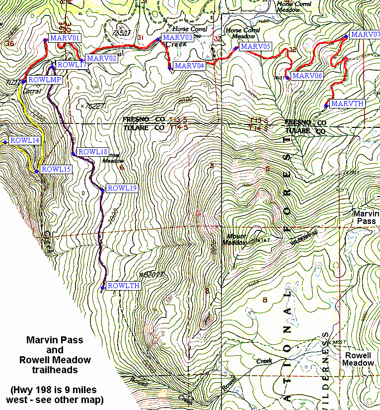
Marvin Pass Trailhead - red line on the trailhead map above
Rowell Meadow Trailhead - dark line on the
trailhead map above