Sierra Peaks - Region 16
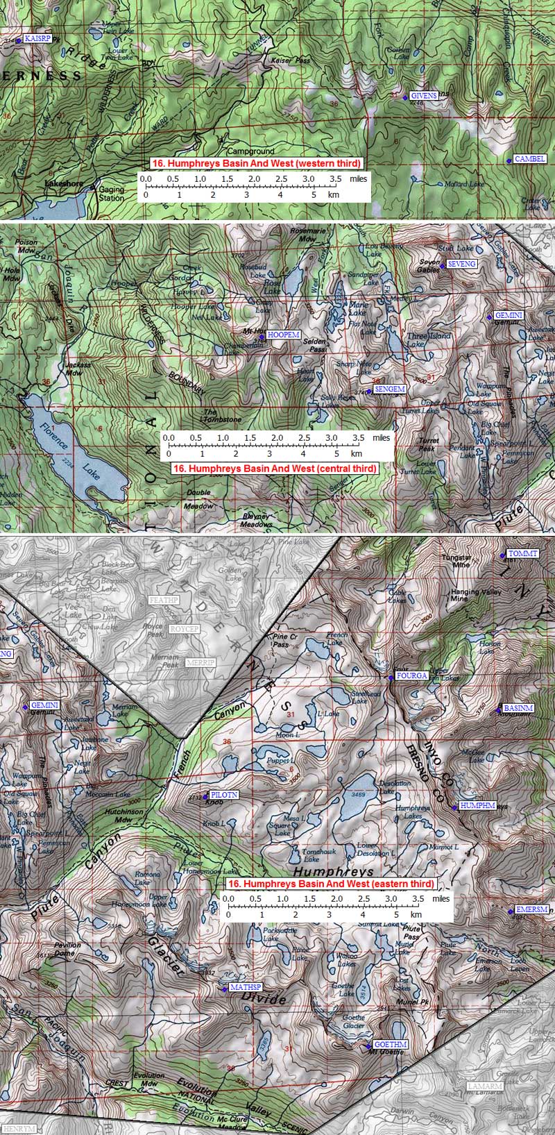
Humphreys Basin And West
Generated on 10 Aug 2024 - see revision history - please send updates to the webmaster
|
Humphreys Basin And West sorted numerically on Num column | ||||||||||||||
| Click on the peak name for similarly named peaks in a statewide peaks database. | ||||||||||||||
| click on these headings to sort by that column | click on these headings for more info | |||||||||||||
| Num | Peak Name (more links) | Waypoint | Elev | SPS | Class | Pics and Reports | UTM hint (map) | 7.5' USGS topo quad | Register | |||||
| 16.1 | Goethe Mt | GOETHM | 13264 | 1 | 8 reports on goethe | 490189 | Mt Darwin | |||||||
| 16.2 | Emerson Mt | EMERSM | 13204 | 2 | 1 pic of EmersonMt 6 reports on emerson | 534229 | Mt Darwin | need | ||||||
| 16.3 | Humphreys Mt | HUMPHM | 13986 | E | 4 | 3 pics of HumphreysMt 10 reports on humphreys | 518260 | Mount Tom | ||||||
| 16.4 | Basin Mtn | BASINM | 13181 | 2 | 1 pic of BasinMtn 4 reports on basin | 531289 | Mount Tom | |||||||
| 16.5 | Four Gables | FOURGA | 12720+ | 1 | 1 pic of FourGables 11 reports on gables | 499299 | Mount Tom | need | ||||||
| 16.6 | Tom Mt | TOMMT | 13652 | 2 | 1 pic of TomMt 6 reports on tom | 533335 | Mount Tom | |||||||
| 16.7 | Pilot Knob N | PILOTN | 12245 | 2 | 8 reports on pilot | 443265 | Mt Hilgard | |||||||
| 16.8 | Gemini | GEMINI | 12880+ | 2 | 1 pic of Gemini 5 reports on gemini | 390292 | Mt Hilgard | |||||||
| 16.9 | Seven Gables | SEVENG | 13080+ | M | 2s3 | 1 pic of SevenGables 11 reports on gables | 376308 | Mt Hilgard | ||||||
| 16.10 | Senger Mt | SENGEM | 12286 | 2 | 5 reports on senger | 353271 | Mt Hilgard | |||||||
| 16.11 | Hooper Mt | HOOPEM | 12349 | 2s4 | 6 reports on hooper | 321288 | Florence Lake | |||||||
| 16.12 | Ian Campbell Mt | CAMBEL | 10616 | X | 2 | 2 reports on iancampbell | 209256 | Mt Givens | ||||||
| 16.13 | Givens Mt | GIVENS | 10648 | X | 2 | 3 reports on givens | 179276 | Mt Givens | ||||||
| 16.14 | Kaiser Pk | KAISRP | 10310 | X | 1 | 2 reports on kaiser | 064296 | Kaiser Peak | ||||||
| 16.15 | Matthes Pk | MATHSP | 12989 | X | 2 | 6 reports on matthes | 448207 | Mt Darwin | ||||||
NOTE: M = Mountaineers Peak, E = Emblem Peak, X = not on SPS List (in 'SPS' column)
      ^ = metric contours and elevations on 7.5' maps (in 7.5' map columns)
      Name Mt  => 'Mt' is before peak 'Name' (ex: Rose Mt is Mount Rose, but sorted on 'Rose')
      Name Mtn => 'Mtn' is after peak 'Name' as listed (ex: Muah Mtn is Muah Mountain)
The "UTM Hint" in the table above approximates the peak location to the nearest 100 meters.
Click here for info on Universal Transverse Mercator coordinates.
Useful Links: