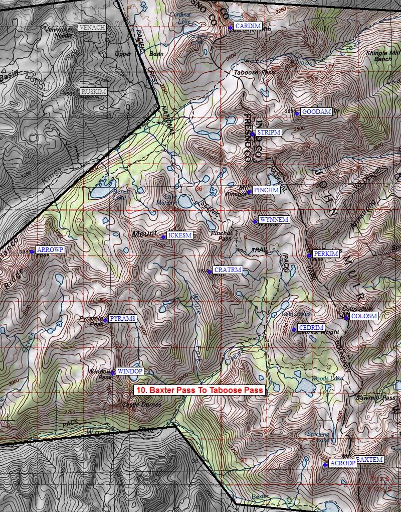
Sierra Peaks - Region 10
Baxter Pass To Taboose Pass
Generated on 10 Aug 2024 - see revision history - please send updates to the webmaster
|
Baxter Pass To Taboose Pass sorted numerically on Elev column | ||||||||||||||
| Click on the peak name for similarly named peaks in a statewide peaks database. | ||||||||||||||
| click on these headings to sort by that column | click on these headings for more info | |||||||||||||
| Num | Peak Name (more links) | Waypoint | Elev | SPS | Class | Pics and Reports | UTM hint (map) | 7.5' USGS topo quad | Register | |||||
| 10.15 | Window Pk | WINDOP | 12084 | X | 2 | 701835 | Mount Pinchot | |||||||
| 10.11 | Cedric Wright Mt | CEDRIM | 12372 | X | 1s3 | 765849 | Mt Pinchot | need | ||||||
| 10.2 | Colosseum Mtn | COLOSM | 12451 | 1 | 3 reports on colosseum | 783853 | Aberdeen^ | |||||||
| 10.3 | Perkins Mt | PERKIM | 12566 | 2 | 3 reports on perkins | 770875 | Mt Pinchot^ | |||||||
| 10.9 | Goodale Mtn | GOODAM | 12772 | 2s3 | 2 reports on goodale | 767925 | Mt Pinchot^ | |||||||
| 10.6 | Pyramid Peak S | PYRAMS | 12779 | 2 | 1 pic of PyramidPeakS 18 reports on pyramid | 698853 | Mt Pinchot^ | |||||||
| 10.13 | Crater Mtn | CRATRM | 12874 | X | 2 | 3 reports on crater | 735870 | Mount Pinchot | ||||||
| 10.7 | Arrow Peak | ARROWP | 12959 | M | 2 | 1 pic of ArrowPeak 7 reports on arrow | 673878 | Mt Pinchot^ | ||||||
| 10.14 | Ickes Mt | ICKESM | 12968 | X | 2 | 719882 | Mount Pinchot | need | ||||||
| 10.1 | Baxter Mt | BAXTEM | 13136 | 2 | 1 pic of BaxterMt 4 reports on baxter | 784802 | Kearsarge Peak^ | |||||||
| 10.4 | Wynne Mt | WYNNEM | 13179 | 2 | 5 reports on wynne | 751887 | Mt Pinchot^ | |||||||
| 10.8 | Striped Mtn | STRIPM | 13179 | 1 | 1 pic of StripedMtn 5 reports on striped | 751918 | Mt Pinchot^ | need | ||||||
| 10.12 | Acrodectes Peak | ACRODP | 13183 | X | 2 | 1 pic of AcrodectesPk | 775801 | Mount Clarence King | need | |||||
| 10.10 | Cardinal Mtn | CARDIM | 13396 | 2 | 1 pic of CardinalMtn 3 reports on cardinal | 744955 | Mt Pinchot^ | |||||||
| 10.5 | Pinchot Mt | PINCHM | 13494 | 2 | 1 pic of PinchotMt 7 reports on pinchot | 749898 | Mt Pinchot^ | |||||||
NOTE: M = Mountaineers Peak, E = Emblem Peak, X = not on SPS List (in 'SPS' column)
      ^ = metric contours and elevations on 7.5' maps (in 7.5' map columns)
      Name Mt  => 'Mt' is before peak 'Name' (ex: Rose Mt is Mount Rose, but sorted on 'Rose')
      Name Mtn => 'Mtn' is after peak 'Name' as listed (ex: Muah Mtn is Muah Mountain)
The "UTM Hint" in the table above approximates the peak location to the nearest 100 meters.
Click here for info on Universal Transverse Mercator coordinates.
Useful Links: