Desert Peaks - Region 5
San Diego and Imperial Counties
Generated on 10 Aug 2024 - see revision history - please send updates to the webmaster
|
San Diego and Imperial Counties sorted alphabetically on Waypoint column | ||||||||||||||
| Click on the peak name for similarly named peaks in a statewide peaks database. | ||||||||||||||
| click on these headings to sort by that column | click on these headings for more info | |||||||||||||
| Num | Peak Name (more links) | Waypoint | Elev | DPS | Class | Pics and Reports | UTM hint (map) | 7.5' USGS topo quad | Register | |||||
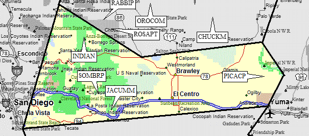
| 5.1 | Indianhead | INDIAN | 3960+ | 2 | 2 reports on indianhead | 531837 | Borrego Palm Canyon | |||||||
| 5.3 | Jacumba Mtn | JACUMM | 4512 | 1 | 1 report on jacumba | 784179 | Jacumba | |||||||
| 5.4 | Picacho Pk | PICACP | 1920+ | 6 | 1 report on picacho | 184503 | Picacho Peak | |||||||
| Picacho Pk is usually called 'Little Picacho' by the DPS, but it is NOT the Little Picacho shown on the topo. | ||||||||||||||
| 5.2 | Sombrero Pk | SOMBRP | 4229 | 2 | 1 report on sombrero | 664327 | Sombrero Peak | |||||||
NOTE: M = Mountaineers Peak, E = Emblem Peak, X = not on DPS List (in 'DPS' column)
      ^ = metric contours and elevations on 7.5' maps (in 7.5' map columns)
      Name Mt  => 'Mt' is before peak 'Name' (ex: Rose Mt is Mount Rose, but sorted on 'Rose')
      Name Mtn => 'Mtn' is after peak 'Name' as listed (ex: Muah Mtn is Muah Mountain)
The "UTM Hint" in the table above approximates the peak location to the nearest 100 meters.
Click here for info on Universal Transverse Mercator coordinates.
Useful Links: