Bishop Area Trailheads
(Horton, North, Sabrina, South Lakes)
Revised 28 Mar 2012 - please send updates to the webmaster
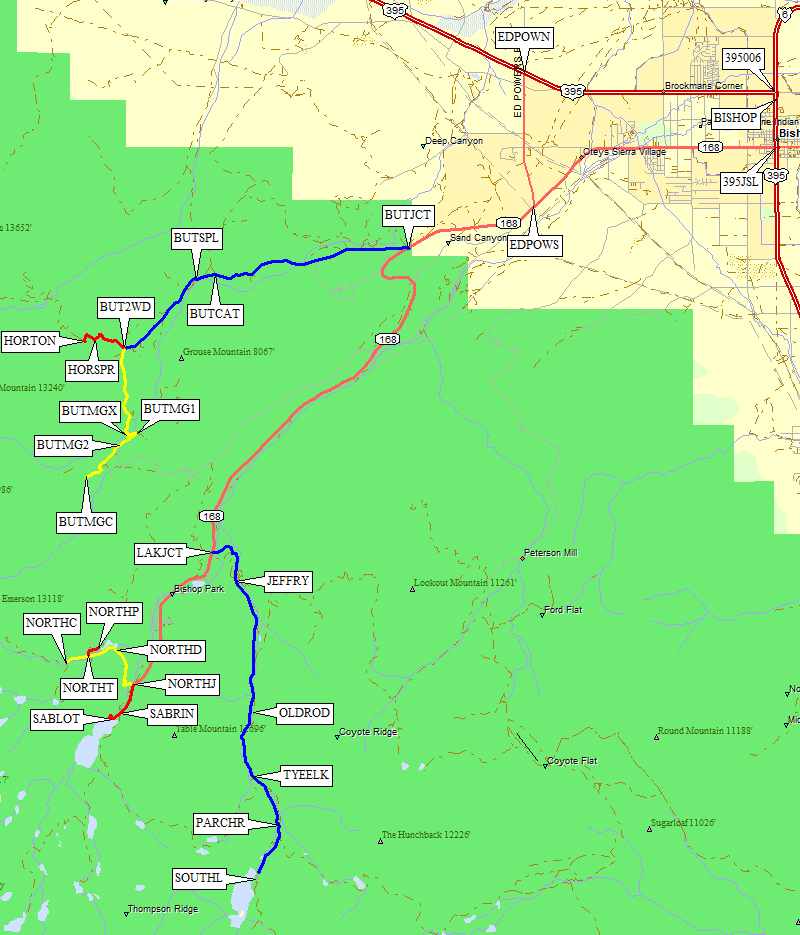
All trailheads in this file are reached by way of Hwy 168 from Hwy 395 in Bishop. Those coming from the north (Mammoth) and not needing to stop in town can shortcut by turning right (south) on Ed Powers Road at waypoint EDPOWN and save both miles and time: see GPS route BISHOP CK FROM NORTH. Those coming from the south (Big Pine) or needing permits/food/fuel will turn west onto Hwy 168 at a stoplight (waypoint 395168)) on GPS route BISHOP CK FROM SOUTH.
Wilderness permits are available at the Bishop Ranger Station, also known as the White Mountain Visitor Center (waypoint BISHOP). They have an extensive collection of maps and books also. See GPS route BISHOP DOWNTOWN.
Regardless of how you get onto Hwy 168, you'll go past the southern end of Ed Powers Road (waypoint EDPOWS, less than 5 miles from Bishop). Those headed for Buttermilk Country will turn right on the dirt Buttermilk Road (waypoint BUTJCT) about 2.6 miles southwest of Ed Powers Road. Others will continue on pavement and climb to the main junction (waypoint LAKJCT, 15 miles from Bishop, 10.4 miles from Ed Powers Road) where you go left to South Lake or continue straight to North Lake and Lake Sabrina.
NOTE: Distance measurements seem to vary from source to source. It's better to use the supplied waypoints than your car's odometer. If you must use mileage, be aware that mileage 'from Bishop' depends a lot on where you consider Bishop to be. The edge of town? The ranger station? Who knows. I do know that the distances I measured with my car do not agree with the length of my GPS track. Caveat Emptor.
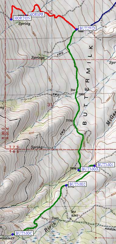
Leave Hwy 168 at waypoint BUTJCT, turning west where there is a large yellow
'T' intersection sign that says Buttermilk Road. This dirt road has
lots of washboards down low and and rocks up high, but no vehicle
clearance problems until you reach waypoint BUT2WD (as far as I got
in my passenger car). The road basically heads straight toward Basin Mtn.
About 3.5 miles from Hwy 168 you cross a cattle guard (waypoint BUTCAT)
and continue going west (straight) on a road labelled 7S01. Half a mile
later (waypoint BUTSPL) there is a split in the road - both branches go
the same place, but the right branch seems a bit better. At this point
the road turns southwest along the north flank of Grouse Mountain,
following McGee Creek, and gets much rockier as you climb to
the final intersection (waypoint BUT2WD) where you choose between the
McGee Creek and Horton Lake trailheads.
NOTE: This McGee Creek is not the same as the
McGee Creek Trailhead
used to climb Mt Morgan! This one is by Basin Mtn.
GPS Routes HORTON LAKE and BUTTERMILK MCGEE
|
Passenger cars may want to stop before the junction at waypoint BUT2WD,
about 6 miles from Hwy 168, at 7500' elevation. Beyond this requires
high clearance (or at least more bravado than I had in my passenger car).
At BUT2WD, there is a sign saying 'Horton Trailhead' to the right.
I have not personally verified the waypoints or description beyond
this point, but the map seems fairly clear and the waypoints are close.
Secor says the Horton Lake Trailhead is 1.1 miles from waypoint BUT2WD, and indicates there should be parking near the spring at elevation 7777' (waypoint HORSPR). Apparently there is limited parking at the Horton Lake Trailhead itself (waypoint HORTON, just under 8000'). Secor also says the Buttermilk's own McGee Creek Trailhead (not the trailhead next Hilton Creek) is 3.1 miles from waypoint BUT2WD. Turn left at the Horton Lake sign mentioned above, and go 1.6 miles south to cross McGee Creek at 7898' (waypoint BUTMGX). Climb out of the drainage and make a hairpin turn at the BUTMG1 junction, then go southwest uphill to the fork at BUTMG2 (leaving Buttermilk Road). Keep going southwest (straight) to the end of the road at BUTMGC, the Buttermilk McGee Creek Trailhead at 8700'. Note that this trailhead is initially closer to Birch Creek than to McGee Creek, but does cross into the McGee drainage. |
|
Drive part way up Hwy 168, turning left off the main road at the South Lake junction
(waypoint LAKJCT). Follow this paved road (the blue line) south to its end at South Lake.
This road is signed (near waypoint JEFFRY) for no camping except in campgrounds.
There is a chunk of the old road behind a large dirt hump (waypoint OLDROD)
downcanyon from the Table Mountain Group Camp which has been used as a bivy site,
and people seem to be left alone when they sleep near the trailhead parking lot
at waypoint SOUTHL. Caveat Emptor.
Continue on pavement past the turnoff to Tyee Lakes (which connects to Lake Sabrina via George Lake). Parchers Resort will be the collection of buildings on your left (waypoint PARCHR). There is a trailhead here for Green Lake (on the way to Cloudripper) but it's well hidden behind the buildings and I never found a trailhead sign. It's easier to go a bit up the road from Parcher's where the trail is about 100' from the road. If the South Lake parking lot is full, you'll have to park downcanyon from Parchers and walk about 1.5 miles. There is another sign here that says camping and overnight parking is prohibited between Parchers and the trailhead. Bear left at the boat launch, following the parking sign to the main trailhead parking (waypoint SOUTHL). There are pit toilets and bear boxes on the southwest end of the lot. There is a utility road that leaves the north end of the lot and offers some peace and quiet for overnight bivys. This is a busy trailhead! It serves not only Bishop Pass and Dusy Basin, but also local lakes (Treasure, Chocolate) where people go to fish and hang out. |
|
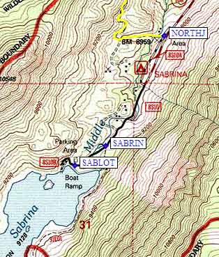
Drive to the end of Hwy 168, staying on the main road and making no turns as you
go southwest past the South Lake (waypoint LAKJCT) and North Lake (waypoint NORTHJ)
junctions (the red line). The main Lake Sabrina trailhead is at waypoint SABRIN,
but there is no formal parking lot (just pullouts along the road), there is limited
parking in the area, and some spaces are signed for no overnight parking. The main
formal parking area (waypoint SABLOT) is up by the dam, where the road ends
at a boat landing... which has parking that appears to be day-use only. It's
possible to walk across the dam but the overflow area is difficult - it's easiest
to go back down to the trailhead sign (waypoint SABRIN) and avoid the brush.
Various trail branches take you past George Lake and Tyee Lakes to a trailhead below South Lake, past Baboon Lakes to Thompson and Powell, or past Moonlight Lake to Haeckel and Wallace. There are no easy passes from this trailhead but lots of people go here to fish or hang out around the stunning lakes. |
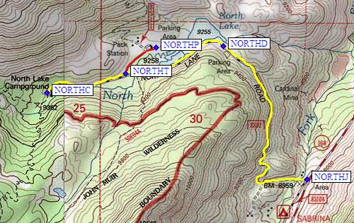
Drive almost to the end of Hwy 168, staying on the main road as you go past
the South Lake (waypoint LAKJCT). Turn right (west) at the North Lake junction
(waypoint NORTHJ, the yellow line). The road becomes narrow dirt with switchbacks,
but is well maintained and any car will do just fine.
The North Lake Day Use parking lot is mostly for fishing (waypoint NORTHD).
Drive past it, to a sign marked 'Pack Outfitter' (waypoint NORTHT) -
there's no indication this leads to the overnight trailhead parking lot,
but it does! Go straight (east) past Bishop Pack Outfitters and you'll
come to two parking loops. Waypoint NORTHP is between the two loops,
near the outhouse.
You have to park beside North Lake and walk over half a mile up the
road to the campground (waypoint NORTHC) where there is a trailhead sign.
No overnight parking near the trailhead unless you rent a campsite!
There is an old trail that goes up from the parking area, but it goes nowhere.
From the trail through the campground you can reach Piute Pass (on the JMT)
and Lamarck Col. The USGS topo maps don't show a trail over Lamarck, and I
remember when that was a cross-country route, but it's been built up by
packers and even has a sign at the pass now. The west side has a reasonable
use trail all the way down the Darwin Bench to the PCT near Evolution Lake.
Useful Links:
GPS Route NORTH LAKE