I had never climbed in this area before and was really curious about the lay of the land in this "far Sierra north". The only plan was to stay until the first signs of winter weather set in. Little did I know then, a strong high pressure system was about to move into the Great Basin for 2 1/2 weeks plus, or the entire duration of this outing. On Oct. 8 I drove from my home in south Orange County to Reno and got a motel room just south of downtown- my "base camp" for about the next week or so. Oct. 9 was cold, gray, with drizzle so I drove north to scout out an approach to Mt. Adams, in the Crystal Mtn. range, the northernmost peak on the SPS list. The only beta I had was an approach from the east written 9 years ago. I found nothing there a low clearance vehicle could handle. These roads have not been maintained and are badly eroded.
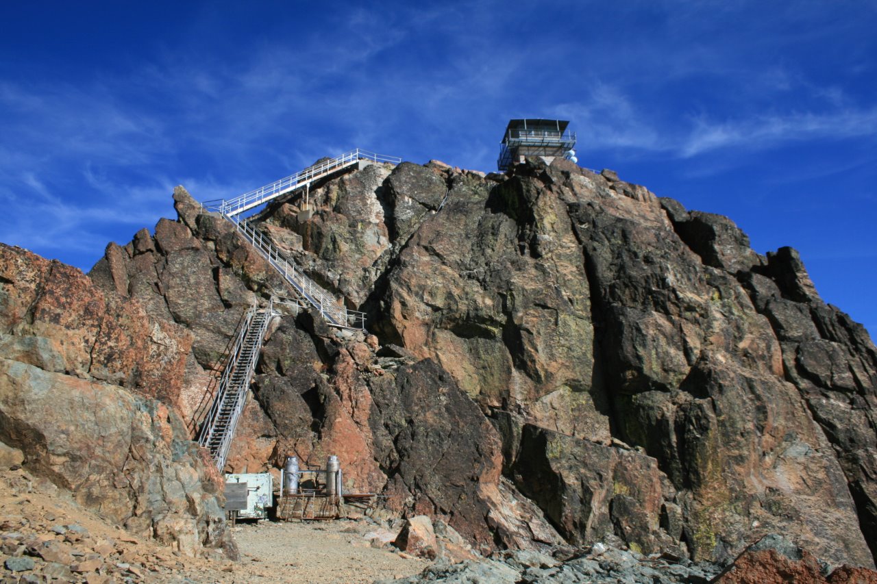
On Oct. 10, with weather still brisk but improving, I headed south towards Mt. Rose, the only SPS peak not in California, and took the standard Mt. Rose trail from Nevada route 431 up to the windswept summit, about 2000 elev. gain and 10 miles round trip on a well marked, well used trail. At the tree line the wind picked up considerably, 30-45 mph. Near the top one lone hiker was returning from the summit. I asked him if he was a local, he was, so in the howling wind I asked him about approaching Mt. Adams. He said to approach it from the west, Frenchman Lake, on a well used dirt road just past the spillway. I made a mental note of what he said, and proceeded to the summit. Windy and clear, with beautiful views of terrain I had never experienced before. On the way back down I detoured slightly to climb nearby Church Peak, which was too close to pass up. Oct. 11- drove west and climbed Sierra Buttes from where the Packer Lake road meets the PCT. Totally incredible lookout station on top built in 1964. Only about 5 miles roundtrip with approx. 1600 ft. of elevation gain, all on trail/dirt road and ending on a super airy staircase. (The summit block looked to be about class 4, minus the staircase.)
Oct. 12- Drove back up north to Frenchman Lake and found the well used dirt road for the west side approach to Mt. Adams. The local hiker's directions were right on. The road is clearly marked- "Adams Peak- 5 miles". It is about a mile or 2 past the spillway and follows the Spring Creek drainage. Further up this road is another sign, "Adams Peak- 3 miles". I parked there ( I didn't want to drive to the top!) and hiked up the dirt road to the twin summits, signed the register and returned the same way. Definitely a good way to climb this peak. The weather was clear. Gusty at the summit, and views were awesome in all directions. Maybe 8-10 miles today. It was probably closer to 4-5 miles one way than 3 miles.
On the road to Adams Pk.
Oct. 13- Rest day in Reno.
Oct. 14- Drove west, climbed Mt. Elwell via the standard route from Gold Lake Hwy. Maybe 5 miles round trip, 1500 ft. of elevation gain. This has got to be one of the tamest peaks on the SPS list. The views of Long Lake were a highlight. Clear, cool, and breezy.
Oct. 15- Climbed Mt. Lola from the north via the standard Mt. Lola trail. 10 miles, 2500 ft. elev. gain, clear, cool and windy. The trailhead sign in Perazzo Meadows is barely legible.
Oct. 16- English Mtn., climbed the wooded western slope directly to the summit, weather remaining stable. This peak needs a summit register. I had one but forgot to put it inside my day pack. Passed beautiful Jackson Lake on the way back down. Be careful here, there's some private property markers at Jackson Lake, some of which I didn't see until the descent. About 4-5 miles today.
Oct. 17- Castle Peak from I-80 via the standard hiking trail through Castle Valley. Climbed the class 3 east face of the summit block then went down and climbed the class 4 west face just to see if I could do it. On the return back to the car, climbed Andesite Peak, a minor bump close to Castle Peak. 6 miles or so today.
Oct. 18- Climbed Granite Chief via the Granite Chief trail in Squaw Valley. Also known as the "fire station trail". The trailhead sign had been knocked down and propped up along the side of the bldg., just out of view from the road. This was a difficult trailhead to locate. It is not the trailhead to Shirley Lake at road's end and I was told they do not connect. The fire station is a low key affair. An unmarked beige stucco bldg. with no fanfare and no signs. The trail itself though is beautiful. About 11 miles roundtrip, maybe 2600-2800 ft. of elev. gain.
Oct. 19- Still anchored in Reno, drove back to beautiful Squaw Valley, took the same Granite Chief trail up to the PCT, at the junction went north and climbed Tinker Knob. Placed a new Sierra Club register in the ammo box, and then returned the same way. About 13-14 miles today (?) (a lot of the mileage on this outing is only a guesstimate.)
Oct. 20- rest day
Oct. 21- Drove to southwest Lake Tahoe and the Mt. Tallac trailhead. (well marked). Climbed Mt. Tallac from there. This was a beautiful fall day. Couldn't have been nicer. This trail sees a lot of use and I can see why. Stunning views of the lake and Desolation Wilderness. Talked to a local hiker/climber, Pete, about climbing Freel Peak. He recommended Armstrong Pass via Oneidas St. He also went on to explain how the development at Tahoe Keys had an adverse effect on the meadowlands that disappeared because of it. Evidently the meadows had a key part in filtering the Upper Truckee that feeds Lake Tahoe. I sympathized. I know about overdevelopment. Remember, I live in Orange County.
Once again, the advice of a local made a big difference. About 10 miles today. About 3500 ft. elev. gain, all on trail. Drove back to my new base camp, in Carson City, Nev. (Remember the govt. shutdown had closed all of the campgrounds)
Oct. 22- Drove back to Fallen Leaf Lake, and took the Alpine Glen trail/route to Dick's Peak. This was a long day. I drank from the soda spring at Glen Alpine and I think I made a mistake by doing so. The climb up the ridge to the final summit, well, I underestimated it. I thought I was going to do Jack's Peak too, but no way. I didn't reach the windy summit until 2:07 PM and the ridge over to Jack's Peak didn't look like a piece of cake. I headed back down. I drank from the soda spring once more. The water was clear. I tasted the soda water on the way up, but on the way down I drank maybe a small cup full. Probably not a good idea. Especially in fall, with low water flow it may have been borderline stagnant. I began to feel the effects the following day.
Oct. 23- Weather as nice as could be, although frosty in the morning (22 degrees in Lake Tahoe). I took Pete's advice and found my way to Oneidas St. in south Lake Tahoe and got to the Armstrong Pass trailhead late. 10:40 AM. Debating at the trailhead whether to wait a day or not, I decided to set off for Freel Peak and took a headlamp for good measure. This great weather could end any day now. Must have been about 14-15 miles today and a little less than 3000 ft. of el. gain. I got back in the dark but not before placing a new summit register in the ammo box on the summit. Actually, I left the summit at about 4 PM. The shadows over Job's Sister made for some nice photos. The views from Freel Pk. were stunning, at 10,881 ft. it's the highest of the Lake Tahoe rim peaks. Windy, again, up on top, I headed down feeling a little under the weather. Severe coughing, headache. Something was up. Back to Carson City.
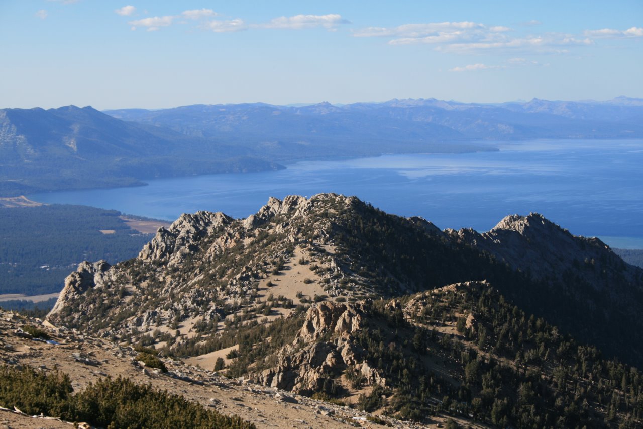
Southern tip of Lake Tahoe from the upper slopes of Freel Peak. Trimmer Peak in foreground.
Oct. 24- coughing badly, headache. Immune system compromised. rest day.
Oct. 25- I figured it was time to call it quits, the body is no longer co-operating. I began the journey home.
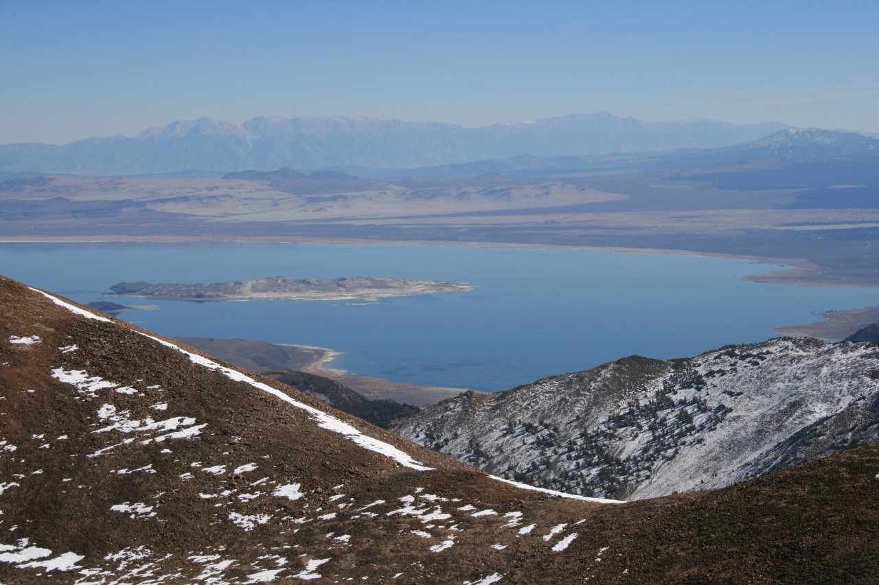
But just as I passed Bridgeport, the official Fairbanks, Alaska weather city in California, I defied all common logic and climbed the south slope to the summit of Dunderburg and had a somewhat enjoyable birthday. This peak has neither a summit box or a register but it sure has some fine views of Mono Lake. And a very nice class 2 climb to the top. At elev. 12,374, I felt like I was back in the original Sierra's again. What a view of Whorl Mtn.
Mono Lake from upper slopes of Dunderburg Pk
13 SPS peaks, 2 non SPS peaks, about 110 miles. All in good weather conditions. This trip exceeded all expectations.
In retrospect, these were all some of the least difficult peaks on the SPS list. Much smaller gems than the 13er's, but still gems in their own right.