As you might suspect from the subtitle of this report, the driving approach was the most challenging feature of this desert peak. The DPS drive instructions start in the casino border town of Primm, and we got there just after nightfall. If you are not into gambling, Primm is just downright grim. No grocery stores here to speak of, only a few massive smoke-filled gambling establishments, throngs of impatient people and high-priced gasoline stations.
The driving instructions out of Primm in the DPS Guidebook (3th ed.) does not work anymore. I even had Zdon's desert guidebook with me, but it was just as outdated. The DPS Guidebook says to drive behind Buffalo Bills (BBs) casino to find the dirt road out of town. However, numerous No Trespassing signs now dot the paved road out of town behind the casino. In addition, if there were any dirt roads that led out the parking area behind Buffalo Bills, they are gone now. Acres of desert behind casino have been graded into oblivion.
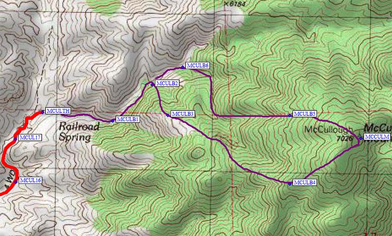
Flailing around in the darkness looking for the start of this route was getting us nowhere, so we stayed at Buffalo Bills for the night. Rooms are cheap on weekdays, only 30 bucks. As luck would have it, a security guard in the casino provided us with the info we needed to start our drive to McCullough Peak in the morning. However, we spent a good three hours checking out dirt roads in the area before we found the fastest way to the Route B trailhead. Below is the description of just how to do that. However, for waypoints and more detailed description of specific distances between turns, please refer to the trailhead page, where you'll find waypoints (including the drive and the climb) and maps of the drive. See below for a detaild map of the climb.
The new start to the drive out of Primm goes like this: Take the exit off I-15 in Primm and drive to the 4-way stop light intersection just west of the freeway. This intersection is at the entrance to Buffalo Bills casino. Take a left at the light, heading onto a frontage road between the freeway and the casino parking lot. The pavement of the frontage road will end soon after passing the casino. About 100-200 feet before the end of the pavement, turn right onto an unsigned, but excellent dirt road which appears to be an access road leading to the many power lines just east of Primm. There are Private Property signs on this road, but no explicit warnings about no trespassing. My feeling is that you are OK on these roads if you stay on the road, keep moving, and leave the power lines alone. By the way, do not take the right onto the dirt road at the very end of the pavement of the frontage road. This road will dead-end in a few miles.
After turning right onto the correct dirt road, continue straight until you get to a railroad track. If you took the right set of forks in the dirt road on the way here, you will find yourself at the RR crossing. If not, you'll find that the railroad tracks are high on a bed of rock and are not crossable. So, do as we did, turn right and follow a dirt road beside the railroad tracks about 200 feet over until you get to the RR crossing. From what we could tell this was the only feasible crossing of the railroad tracks for miles around.
Once over the tracks, continue straight on more excellent dirt road following power lines until you get to an area that is criss-crossed with numerous power lines. There are also a myriad of dirt roads here criss-crossing with the powerlines. The object now is to jog over left about 50-100 feet on a dirt road (there could be several to chose from) that takes you to a very wide dirt access road that runs between two sets of power lines running NE towards the northern end of the Lucy Gray Mtns. As a check, other than the two sets of power lines you are between, there should only be one other row of power lines off in the distance to your left. This access road is also in excellent shape.
The DPS driving instructions encourages you to drive over Beer Bottle Pass because it saves 2.1 miles, as opposed to driving around the Lucy Gray Mtns. Unless you are really into gnarly four-wheel driving, I would recommend not driving over Beer Bottle Pass. As an aside, we checked it out and found it to be steep and very rocky. I gave up on it 0.25 miles in for fear I was going to wreck my Jeep Cherokee. The drive around Lucy Gray Mtns is longer, but much faster. In fact, it is likely faster than driving over Beer Bottle Pass, if it's even passable.
Just past the northern end of the Lucy Gray Mtns, begin to look for a dirt road off to your right. There were at least two dirt roads heading south in this area. We tried both, and we found they eventually ran together into one road that heads south. Going south for several miles into the valley between the McCullough range and the Lucy Gray Mtns, you will intersect a well graded road that comes down from the other side of Beer Bottle Pass.
From this intersection, the DPS instructions work fairly well to get one to the trailhead. Turn left and go about 0.1 mi. and then turn south again for a little over 2 miles. Coming to a corral and water tank, turn NE for 0.25 miles, then turn right heading south again. The DPS instructions seem to suggest 2WD vehicles can still go beyond this point. Not anymore. Deep sand is encountered as soon as you turn south again, and high-clearance 4WD becomes mandatory. The tire ruts created in the sand by previous 4WD vehicles using this road are very deep and my Jeep Cherokee barely had the clearance. In addition, the road has many high banked turns and numerous large rocks mixed in the sand. We spun and slid our way through the sand for about 5.1 miles, but seemed much longer. Finally we reached a sign that announced you were in the McCullough Mtns Wilderness. Amazingly, my Jeep never got bogged down in the sand.
About 50 feet beyond the sign is a faint dirt track running east up a wash. This is the road leading to the trailhead. If you come to the corral mentioned in the DPS instructions, you have gone about 50-100 yards too far. Compared to the sand pit I just drove through, this was an enjoyable 4WD run. However, vegetation has overgrown the road in places and left new racing stripes on the sides of the Jeep.
Daryn and the Jeep at the trailhead cabin.
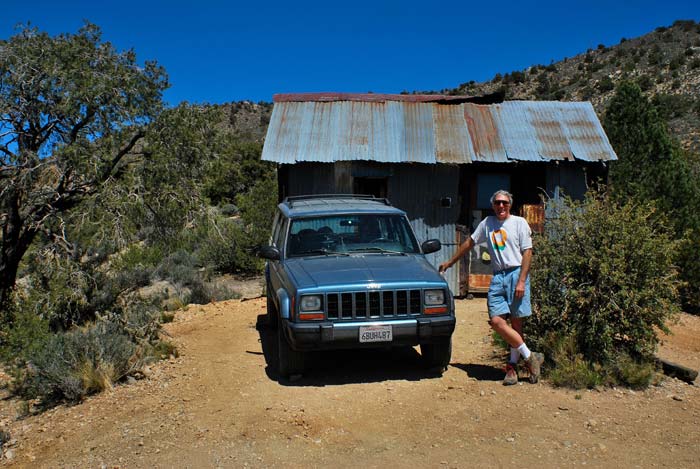
We parked at the cabin at the end of the road (waypoint MCULTH). After three hours of sometimes white-knuckle driving, we were finally ready to go hiking. Leaving the cabin, we first dropped east down into the drainage holding Railroad Spring. Don't count on drinking any of the water here. It was barely running when we were there. And it has been visited by many cows with poor bowel control. It's absolutely polluted. Following the DPS route description, we headed up the wash for a little over a mile, clambering over occasional easy dry waterfalls. We then headed south out of the wash and up through pinyon pines onto a mostly open ridge (waypoint MCULB3). We then followed the ridgeline to the summit.
Compared to the drive to get here, the hike was very pleasant stroll with almost no bushwhacking. It only took 1 hr 20 min from the trailhead to the top. There is a strong sense of isolation this far back into desert territory, but made the climb from this side of McCullough much more interesting. The McCullough Mtn range is different from other desert peaks we recently climbed, as it is largely covered by a healthy-looking pinyon pine forest.
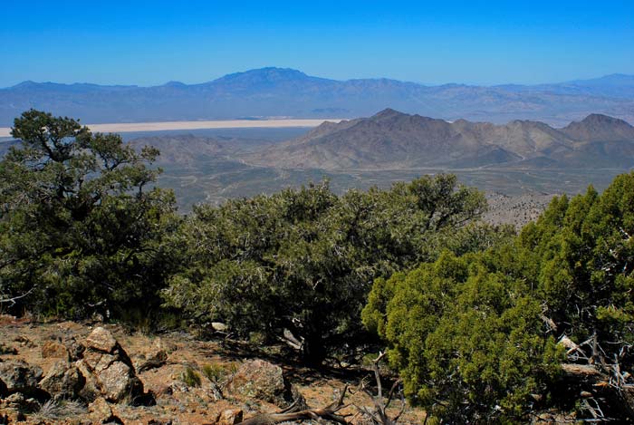
View from the summit. Lucy Gray Mtns in the middle distance, and Clark Mtn in the background.
On the way down, we chose to drop into the gully (waypoint MCULB5) immediately north of the ridge we had followed up. This section was also an enjoyable hike, but was a little more rocky and brushy than the ridgeline run. The drive back to Grim Primm only took two hours, now that we knew the route.
Map of our climb (purple line from MCULTH to MCCULM).
All waypoints and driving directions/maps are on the
trailhead page