We began our dayhike at the campground (waypoint CHIMNY) at 6 am with just enough morning light to avoid using headlamps. The campground was deserted this time of year and the water faucets in the first campground all highly recommend not using it for drinking water (what is it good for then!). It took us 2 hrs and 40 min to cover the 7 miles to a saddle on the Sierra crest (waypoint PCTJCT). This section of the PCT is in good shape and easy to follow. The saddle is used as the standard jumping off point for the cross-country traverse below the Sierra crest ridge over to Spanish Needle. The view towards Spanish Needle from this vantage point, still 0.6 miles away, is rather demoralizing. Much steep side-hilling over loose rocks and ridges with some bush-whacking awaits the climber just to get to the base of the Needle. And most of the Needle is hidden from view behind its closer, but shorter, northern summit.
It was here we made the somewhat dubious decision to try another route. Linda had been in contact with some fellow climbers who suggested we should try following the trail for another 3 or so miles, basically around a spur ridge to the west side of Spanish Needle until the trail passes under the Needle. The 7.5 minute map showed the trail as passing within several hundred feet below the Needle on the western side, resulting in what looked like an easy cross-country climb to the base of the peak. Linda's climbing friends also suggested we bring a rope and harness because the final assault on the Needle is much harder than expected. That's not what I understood from reading past trip reports, but we all brought climbing gear anyway.
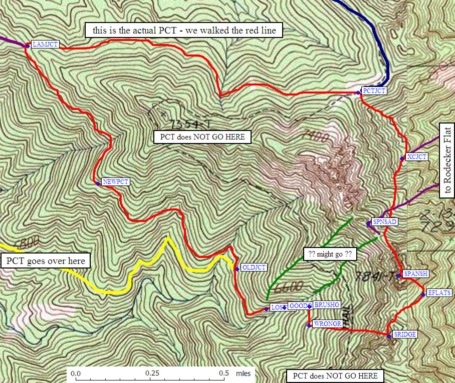
Let me just banish the thought right now for anyone thinking about trying this route based on what they see on the 7.5 minute map because its just plain WRONG! On the 7.5 minute map, the trail is shown as working its way west up and around a spur ridge, then coming back east to join the main Sierra crest again right under Spanish Needle. What the trail actually does was start a steady descent west from the saddle until it reaches another saddle (waypoint LAMSAD) that connects East Lamont Peak with the Spanish Needle spur ridge. The trail then continues to descend further as it works its way back east towards Spanish Needle. But then the trail suddenly turns away from the Needle (at waypoint OLDJCT on the map below), and zig-zags its way down southwest into the valley below (anyone wanting to find a correct map of the trail in this area will have to get the rather hefty book called Pacific Crest Trail: California, by Winnett, Schafer, Shiffrin, and Jenkins).
Watching his altimeter, Steve ticked off every 100 feet or so of elevation loss as we hiked down the trail from the main saddle. Linda suggested a little more strongly each time we lost another 100 feet that we should go back to the saddle and do the standard route. The men on this hike were being rather bull-headed...we were going to make this route work! By the time we got to the point where the trail turns southwest away from the Needle, we had lost over 500 feet and Steve, Linda and I were now all singing the same tune about turning around. Just then, Larry happened to find the old trail where it intersects the main trail, right at the point the trail turns southwest (waypoint OLDJCT). So with some trepidation, we started to follow the old trail towards Spanish Needle.
The old trail was obliterated in numerous places by brush and rock/mud slides making progress slow. But eventually we found ourselves roughly 1300 feet below the low point between Spanish Needle and its lower northern peak...about 400 feet lower than the old trail shown on the map. We started up a rocky gully (waypoint GOODG) towards the low point on the ridge that was rather enjoyable. The brush was not as bad as expected and the footing was fairly solid. After some 400 feet of climbing we moved right to a sandy ridgetop (waypoint WRONGR) and followed this until we got near the base of what we thought was Spanish Needle. The trees and brush were high enough we could not see our objective during most of the climb. The climbing had become steeper and more difficult we neared the ridge, hitting a few exposed class 3 sections along the way.
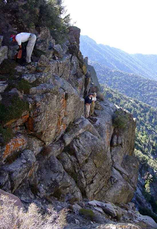
The climbing got noticeably steeper as we neared the summit ridge.
(click on any picture for a larger version)
Reaching the ridge itself, at waypoint SRIDGE, we thought we were at the base of Spanish Needle, but it just didn't feel quite right. Steve pulled out his GPS and sure enough, we had overshot Spanish Needle by 0.15 mile. The only consolation we had for over-shooting the peak this far was that we had a rare close-up view of the south side of Spanish Needle. It actually looks somewhat needle-like from this direction. We worked our way about 150 down from the ridge to get around a cliff, and then contoured across to the base of the peak. We had burned most of our daylight hours by this point, so when we saw a distinct chute on the east side of the needle that appeared to go straight up to the summit we decided to take it. Never mind it was steep and we could not see the entire route due to trees and brush in the chute.
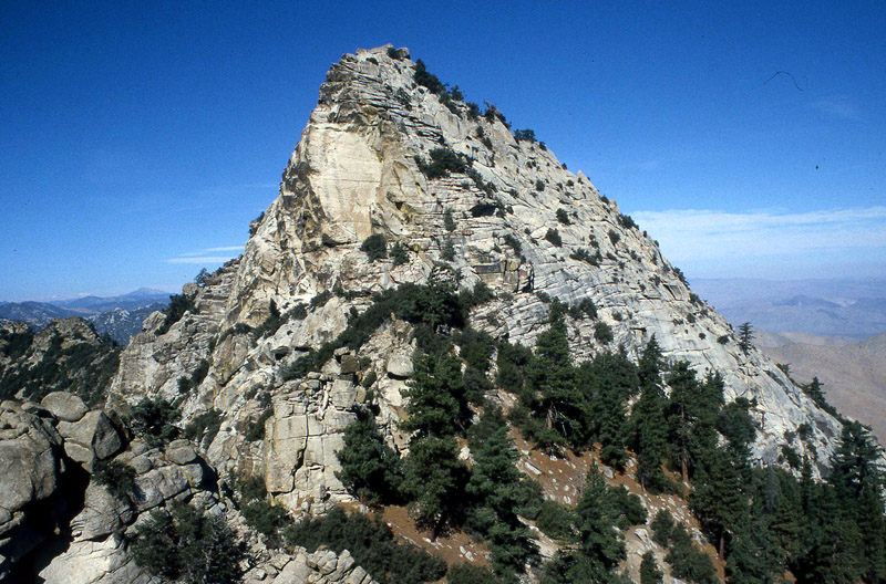
A rare sight...the south face of Spanish Needle.
The beginning of the East Chute Route is just around the corner of Spanish Needle on the lower right side.
The first several hundred feet of climbing went rather well...mostly steep sand and rock with a few spots of brush to work around. But then the chute pinched off into a cliff band that involved about 20 feet of class 4-5 climbing. As we looked around mulling over our dilemma and the lack of good holds, Steve abruptly started climbing the left side of the pinched off chute. He didn't make it look particularly easy, but he made it work. After setting up the rope, Steve belayed the rest of us up.
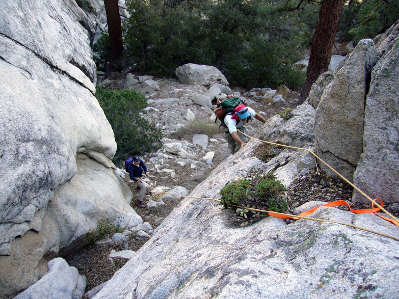
The first belay in the East Chute.
We thought we now had a steep class 2-3 stroll right up the summit rocks. But after 100 feet of climbing, we came to a 20 foot-high chockstone that blocked further progress. Larry managed to make the left side of the chockstone go, sticking in a nut along the way, and he then belayed the rest of us up. Larry thought the move around the chockstone went class 5.4-5.5, while Linda gave it a 5.8-5.9 rating. I think it's probably in between or at the higher end...we simply didn't have enough daylight left to spend the time to finesse it free of aid.
Another 50 feet up, we found yet another chockstone blocking the chute. It was now my turn to take the lead, but this chockstone was smaller and easier to get around, involving a low class 5 move. Larry followed and we set up a belay for the others.
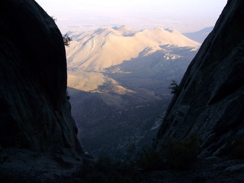
View towards the desert from the East Chute.
Finally, the obstacles were over and after some 200 feet more of easy class 2-3 climbing over crumbly granite, we were on the summit (waypoint SPANSH). It was 4 pm and the sun was setting in about an hour. No time really to relax much, so we shoved some food down and started back. An advantage of the east chute route (probably the only one) is that it goes up behind the usual obstacles for climbers coming from the north. However, it was clear we needed to take the shortest way back, and made a beeline for the saddle at the PCT.
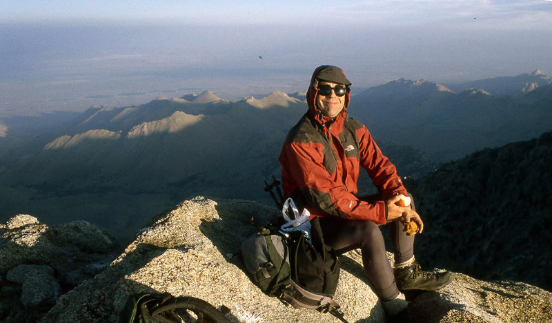
Steve Eckert on Spanish Needle, relishing the thought of a 6 hr hike back to camp with only an hour of daylight left.
In getting down off the summit, Linda and I chose the so-called class 4 chimney. It was by far the easiest climb of the day. I've done stuff rated class 3 that was harder than this! Steve and Larry tried the friction slab, which looked pretty dicey being covered with lichen. But it was quick and easy to protect. Larry threw a rope around a small tree at the top of the slab and I belayed him down.
We then proceeded down near or on the ridge and then dropped over the east side for the side-hilling fun-fest. We didn't get far before darkness descended and we switched on headlamps. While fiddling with the headlamps for the long night ahead, I left my walking pole behind. No big monetary loss because I found it some 3 years ago sticking out of a block of ice near the shore of Lake Helen of Troy. It will now pass on to the next climber who finds it.
The Jenkins Southern Sierra guidebook suggests side-hilling across just below the level of the saddle where the PCT is located. However, with Steve's encouragement, we descended 100-200 feet in a couple places during our traverse to avoid brush and steep ridges. This seemed to work better and go just as fast. The most tedious part of side-hilling was the loose rock which we continually stumbled over in the darkness. I took a good slider at one point and got a case of rock rash. Eventually, we found ourselves about 400-500 feet below the saddle (waypoint XCJCT, where Steve's old route from Rodecker Flat comes up), where we followed a broad sandy, brushy chute up back to the trail. Steve's GPS unit was invaluable for the traverse back to the trail in the dark, in that it helped us feel at ease about where we were in relation to the trail.
The 7 mile plod on the trail back to camp went well and was easy to deal with for nighttime travel. To help pass the time on our walk back Steve recited a number of ribald jokes that got a few laughs, but mostly a lot of groans. Camp was reached at about 10 pm. Back at my tent, a raccoon had at some point made off with a plastic bag left outside my tent that apparently smelled like food. Inside the bag was my Yosemite Sierra Cup that had been on all my climbing trips since 1980. It was no where to be found. Alas, another big sentimental loss to go along with my earlier misplaced walking pole.
The good news was that, regardless of the stress of an 18 mile day and getting back much later than expected, the four of us were all still on speaking terms with one another. Surely an excellent sign that a successful climbing trip had just concluded.
Click the link below for an interactive map.
![]() Download the Waypoint+ data below as a GPX file for your GPS.
Download the Waypoint+ data below as a GPX file for your GPS.
Datum,North America 1983,GRS 80,0,-1.6E-7,0,0,0
RouteName,1 ,SPANISH SOUTH
RoutePoint,D,CHIMNY, 35.8388435841,-118.0431156158,04/12/2000,21:17:48,CHIMNEY PEAK CAMPGROUND
RoutePoint,D,CANPCT, 35.8357166052,-118.0439832211,04/12/2000,21:17:48,CANEBRAKE RD AT PACIFIC CREST TR
RoutePoint,D,SAWTRS, 35.8188999891,-118.0162832737,04/12/2000,21:17:49,LEAVE TRAIL FOR SHORT SAWTOOTH
RoutePoint,D,SAWTRL, 35.8115333319,-118.0089665651,04/14/2000,00:48:55,LEAVE TRAIL FOR SAWTOOTH LONG
RoutePoint,D,PCTSAD, 35.8044099808,-118.0128899813,10/27/2006,19:18:55,SADDLE NEAR SAWTOOTH
RoutePoint,D,PCTJCT, 35.7803399563,-118.0038199425,10/27/2006,19:17:55,XC ROUTE LEAVES PCT
RoutePoint,D,LAMJCT, 35.7825968266,-118.0236425400,12/14/2006,19:45:23,LAMONT XC JUNCTION
RoutePoint,D,NEWPCT, 35.7758899927,-118.0194200277,11/14/2006,08:12:41,A SPOT THE PCT REALLY GOES THRU
RoutePoint,D,OLDJCT, 35.7717100382,-118.0110800266,11/14/2006,08:12:41,OLD TRAIL SOUTH - NEW TRAIL WEST
RoutePoint,D,LOSTTR, 35.7697600126,-118.0093300343,11/14/2006,08:12:41,LOST OLD TRAIL HERE
RoutePoint,D,GOODG, 35.7698199749,-118.0082600117,11/14/2006,08:12:41,GOOD PART OF GULLY
RoutePoint,D,BRUSHG, 35.7698600292,-118.0067499876,11/14/2006,08:12:41,LEFT GULLY TO AVOID BRUSH
RoutePoint,D,WRONGR, 35.7689299583,-118.0067600012,11/14/2006,08:12:42,WRONG RIB SHOULD HAVE STAYED NORTH
RoutePoint,D,SRIDGE, 35.7684400082,-118.0019700527,11/14/2006,08:12:42,RIDGE XING S OF PEAK
RoutePoint,D,EFLATS, 35.7704600096,-117.9999200106,11/14/2006,08:12:42,EAST SIDE FLAT SPOT
RoutePoint,D,SPANSH, 35.7713778019,-118.0013771057,04/12/2000,21:17:51,SPANISH NEEDLE 7841
RoutePoint,D,SPNSAD, 35.7739319801,-118.0032345057,04/12/2000,21:17:48,SHOULD HIT RIDGE SE FROM HERE
RoutePoint,D,XCJCT, 35.7770999670,-118.0011832714,04/12/2000,21:17:48,BEST APPROACH FROM EAST OR WEST
RoutePoint,D,PCTJCT, 35.7803399563,-118.0038199425,10/27/2006,19:17:55,SADDLE NEAR SAWTOOTH
RoutePoint,D,PCTSAD, 35.8044099808,-118.0128899813,10/27/2006,19:18:55,XC ROUTE LEAVES PCT
RoutePoint,D,SAWTRL, 35.8115333319,-118.0089665651,04/14/2000,00:48:55,LEAVE TRAIL FOR SAWTOOTH LONG
RoutePoint,D,SAWTRS, 35.8188999891,-118.0162832737,04/12/2000,21:17:49,LEAVE TRAIL FOR SHORT SAWTOOTH
RoutePoint,D,CANPCT, 35.8357166052,-118.0439832211,04/12/2000,21:17:48,CANEBRAKE RD AT PACIFIC CREST TR
RoutePoint,D,CHIMNY, 35.8388435841,-118.0431156158,04/12/2000,21:17:48,CHIMNEY PEAK CAMPGROUND