Whitney Area
(Whitney Portal, Meysan Lake)
Revised 11 May 2016 - please send updates to the webmaster
WARNING: Bears are very active at Whitney Portal, and will break into cars just to see if food might be there - even if no food is there.
Take the Whitney Portal Road west from the stop light in the center of Lone Pine (waypoint LONPIN). 3.1 miles from Lone Pine continue straight (west) past Horseshoe Meadows Road (waypoint HORSEJ) if you're headed to the Mt Whitney trailheads. Just after the Olivas Ranch turnoff (waypoint ORRJCT, 5.6 miles from Lone Pine) there is a "No Snow Removal" sign. The road remains open beyond here in the winter, but you may get snowed in.
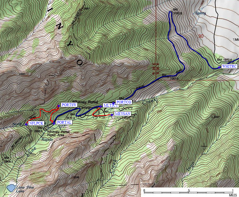
There is a winter road closure 8.3 miles from Lone Pine (waypoint WHITRC at 6.6k) just above the intersection with Hogback Road. The rangers say you'll get a ticket if you drive around the Road Closed signs. In April 2011 road crews had lined up boulders to block the pavement, but people moved the sign and drove past the barricade to the Whitney Portal Campground at 7.8k... and I saw no tickets. A local told me drivers shuttling packs were generally left alone but overnight parking would draw a ticket. Caveat Emptor! It's safer to park in the large dirt lot below the barricade and walk up the 3.4 miles of pavement from the closure to the Whitney Portal trailhead.
'Wag Bags' are required all year, and you are supposed to pack your own waste out to the specially marked receptacle by the Portal restroom. I wonder how (or IF) this gets emptied in the winter. Wag Bags are free at the Lone Pine Ranger Station, which is not actually IN Lone Pine, but almost 2 miles south at the intersection of Hwy 395 and Hwy 136 (waypoint LPRANG). This "Interagency Visitor Center" is gated at Hwy 136 overnight, but there is a self-issue permit kiosk (for off-season use) just east of the gate where Wag Bags may or may not be available.
The GRANIT and OLIVAS waypoints on this map are trailheads for Tuttle Creek.
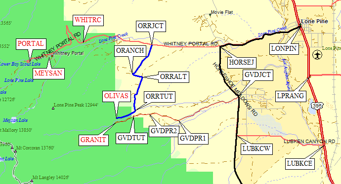
The Whitney Portal Campground (waypoint PORTCG) is the first turnoff beyond the huge switchback above the winter road closure. Less than a quarter mile beyond that campground turnoff there is a signed turn to Meysan Lakes Trailhead Parking. The trail up to Meysan Lake (for peaks like LeConte and Lone Pine) starts in a campground just downhill from the portal road (waypoint MEYSAN at 7.9k) and goes through an isolated pocket of private housing before following Meysan Creek up the drainage just south of the Whitney trail.
Follow the pavement all the way to Whitney Portal (the big tourist destination). The trailhead (waypoint PORTAL at 8.3k) is marked with a huge unroofed structure where people can meet, and a restroom (with nearby Wag Bag depository) is available all year. The Mt Whitney Trail starts from road's end (waypoint PORTAL at 8.3k), and later splits into the Mountaineer's Route (waypoint NFLPCK at the North Fork of Lone Pine Creek and the easier walking trail (past Mirror Lake and over Trail Crest).
In winter the road is closed (waypoint WHITRC at 6.6k) just past Hogback Rd, 3.4 mi from PORTAL.
Useful Links: