Tuttle Creek
(Granite View Dr, Olivas Ranch Rd)
Revised 1 Dec 2015 - please send updates to the webmaster
WARNING: Bears are very active at Whitney Portal, just a short distance away.
NOTE: This is not the road Secor suggests to reach the southeastern side of
Lone Pine Peak, but it's better road and it avoids a nasty crossing of Tuttle Creek.
Both 2WD and 4WD parking areas are at the same altitude as those on the other side
of the creek.
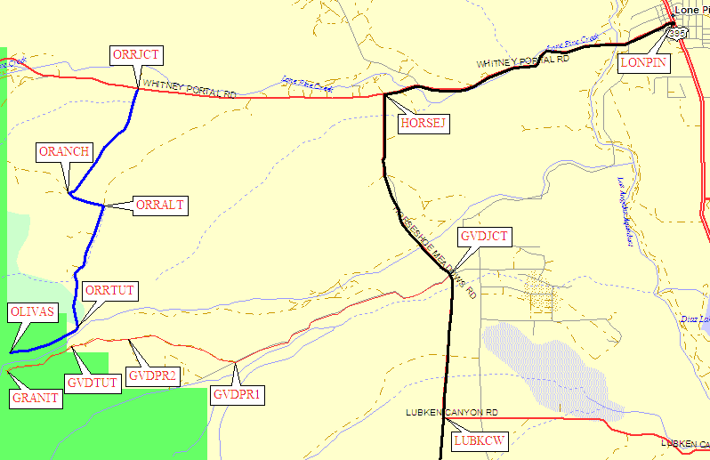
Take the Whitney Portal Road west from the center of Lone Pine (waypoint LONPIN).
About 3 miles from Lone Pine continue straight (west) past Horseshoe Meadows Road
(waypoint HORSEJ). About 5.5 miles from Lone Pine, turn left (south) at the dirt
Olivas Ranch Road (waypoint ORRJCT, with a small green road sign). This is a
great dirt road until you go past the ranch. Almost 7 miles from Lone Pine you
turn left (east) at an unmarked junction with the ranch driveway (waypoint ORANCH).
About a quarter mile further you turn right (south again) at an intersection with
a 4WD road (waypoint ORRALT, an alternate route back to Whitney Portal Road).
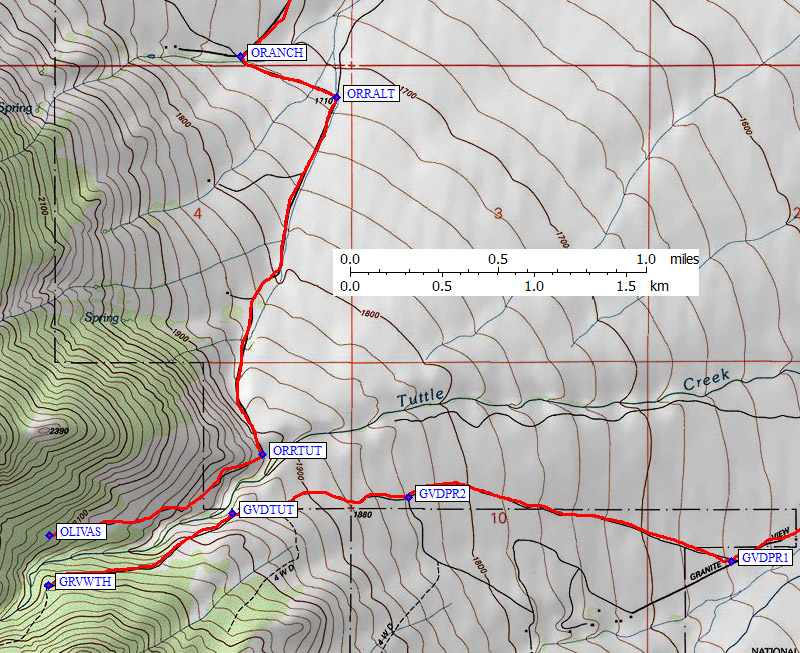
Continue south to the base of the mountain, where you turn west to parallel
Tuttle Creek (waypoint ORRTUT, at 6350', about 8.5 miles from Lone Pine).
This is as far as passenger cars can go, and there is a very wide section of
road for parking. Around the corner the road soon requires high clearance 4WDs...
but if you have the right vehicle you can drive another 3/4 mile to the road's
end at 6950' (waypoint OLIVAS, a small sandy turnaround with some wooden
posts marking the end of the road but no trailhead sign).
NOTE: This is the road Secor suggests to reach the southeastern
side of Lone Pine Peak, but it's worse road and it requires a nasty crossing
of Tuttle Creek - use Olivas Ranch Road instead.
Both 2WD and 4WD parking areas are at the same altitude as those on the other side
of the creek.
Take the Whitney Portal Road west from the center of Lone Pine (waypoint LONPIN).
About 3 miles from Lone Pine turn left (south) on Horseshoe Meadows Road
(waypoint HORSEJ). About 5 miles from Lone Pine, turn right (west) at a 4-way
intersection in a corner. The dirt Granite View Drive (waypoint GVDJCT, with a
small green road sign) goes up the hill and passes very close to a house. Just
after that house you bear right at an unmarked intersection (waypoint GVDPR1
about 7.5 miles from Lone Pine), because going straight takes you past a
private land sign and into a subdivision. Head west up the hill, past the other
intersection with the private road (waypoint GVDPR2) until you are
close to Tuttle Creek. Passenger cars will have to stop at waypoint GVDTUT,
at 6400', just over 9 miles from Lone Pine. Beyond the small parking area
here the road requires high clearance 4WD... but if you have the right vehicle
you can drive another 3/4 mile to the Granite View trailhead road's end at 6950' (waypoint GRVWTH,
a large turnaround loop with a very small trailhead sign).
Useful Links:
Olivas Ranch Road (much better than Granite View Drive) - scroll down for maps
Granite View Drive (much worse than Olivas Ranch Road) - scroll down for maps
Tuttle Creek Approaches (scroll down for trailhead topo)
Tuttle Creek Trailheads (scroll up for trailhead approaches)