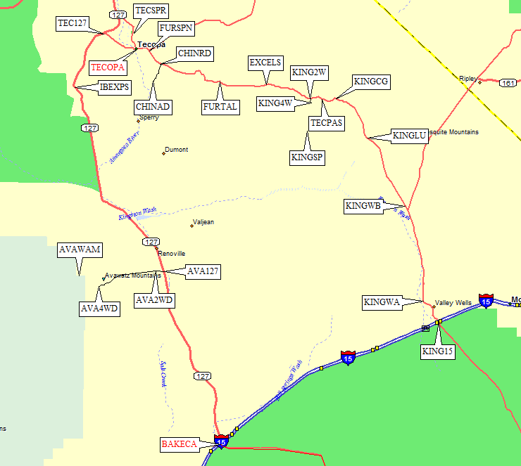
Tecopa Area Peaks
(Pyramid, Smith, Brown, Eagle, Stewart)
(Pahrump, Nopah, Avawatz, Kingston)
Revised 15 Nov 2014 - please send updates to the webmaster
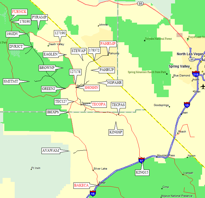
In the triangle formed by Death Valley, Las Vegas, and Barstow, there is a little town called Tecopa (waypoint TECOPA). Tecopa Pass (waypoint TECPAS) is way east of Tecopa, just beyond the turnoff to Kingston Peak. Avawatz is south of Tecopa, halfway to Baker. The other trailheads described below are for peaks between Tecopa and Furnace Creek (waypoint FURNCK) in Death Valley. The only real city nearby is Pahrump Nevada (waypoint PAHRMP), where casinos always seem to have rooms available and gas is cheap.
Most people will probably approach via I-15, heading north from Baker (waypoint BAKECA) on Hwy 127 for Avawatz and the other peaks (except Kingston) below, or north on Cima Road (waypoint KING15) for Kingston. Only those who intend climb BOTH Avawatz AND Kingston are likely to traverse Tecopa Pass (waypoint TECPAS), which connects these two southern approaches via Tecopa (waypoint TECOPA).
If you're already in Death Valley, you can get to Tecopa by taking
Hwy 190 east to Death Valley Junction (waypoint 127190) and going south
on Hwy 127 through Shoshone (waypoint SHOSHN, the only filling station
in the whole area).
Tecopa Area peaks, towns, and intersections -
see below for detailed maps and descriptions of:
See the Overview map for context and connections to this map,
see this 2009 trip report for climbing details.
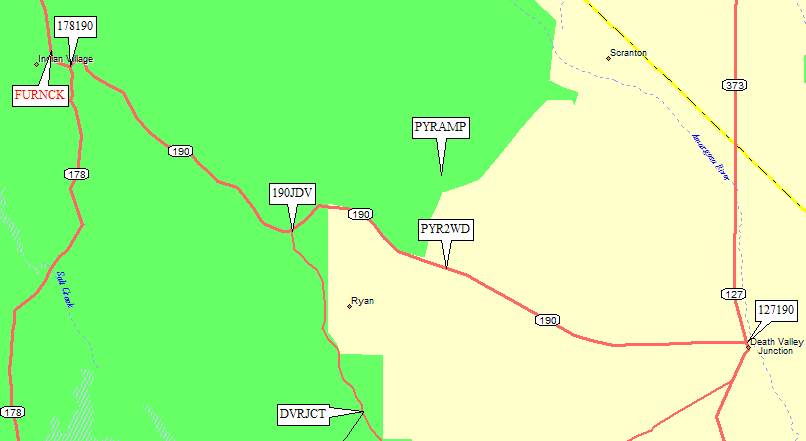
Take Hwy 190 south and east from Furnace Creek (waypoint FURNCK) in Death Valley.
The road climbs from below sea level to over 3000' in about 18 miles.
If you are coming from the south, drive north on Hwy 127 from Shoshone
(waypoint SHOSHN) and turn left on Hwy 190 at Death Valley Junction
(waypoint 127190), then go about 12 miles east to the trailhead.
Near the high point on Hwy 190 (3000', an un-marked pass) you can park
on the north shoulder and walk across the desert to the base of Pyramid.
Exactly where you park isn't very important, but for reference we parked
on the shoulder at waypoint PYR2WD. People were camped nearby on the
south side of the highway, which might be just outside the Death Valley
boundary and therefore legal camping.
See the Overview map for context and connections to this map,
see this 2009 trip report for climbing details.
Furnace Creek Wash Road, also called Greenwater Valley Road, goes from
Hwy 190 in the Furnace Creek Wash (waypoint 190JDV) to Hwy 178 near
Shoshone (waypoint GREENJ). It is paved from Hwy 190 to Dantes View,
then good dirt suitable for passenger cars. Watch out for mud on the road:
when it rained this bladed surface became surprisingly deep (several inches
of mud that didn't LOOK muddy on top) in places.
From the north (Death Valley):
From the south (Shoshone):
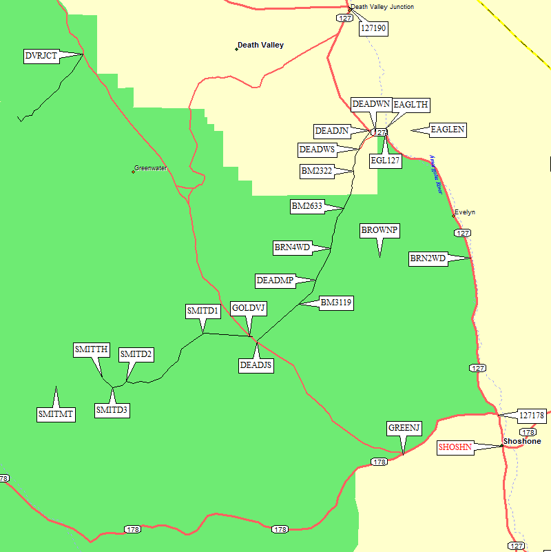
Passenger cars should park at the Gold Valley junction at 3100' (waypoint GOLDVJ).
Some maps call the road west from here the Lost Section Road, and 4WD with
good clearance is required. The road has fairly deep ruts and a few
moderately steep sections. It's 10 miles to the Smith Mtn trailhead, so
plan close to an hour for the drive.
2.5 miles west of GOLDVJ there is a left turn (southwest). The map shows
a junction, but two of the roads are staked closed and don't even look
like roads anymore. The 4WD road bends west and goes over a small saddle
7.5 miles from GOLDVJ. Half a mile later, just before the road turns
due north and drops straight into Gold Valley, we took a shortcut which
seemed better than the 'main' road. The DPS Guide tells you to go over
1000' and 3 miles down the valley, then turn around and come back up
a different road to the trailhead. Our shortcut (from waypoint SMITD2-SMITD3)
is less than a mile long and cuts about 3 miles off the drive.
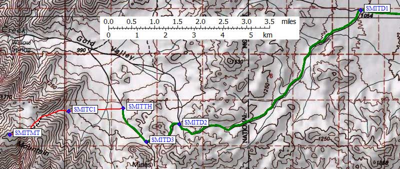
Turn left (west) 9 miles from GOLDVJ (waypoint SMITD2) on an even smaller
track, going about 1 mi over another saddle to a T intersection marked by
a metal pole (waypoint SMITD3). Turn right (north) and go downhill on a
somewhat larger road. 9.8 miles from GOLDVJ, at 3800', there is a small
pullout (waypoint SMITTH). As you walk toward the peak, you may not be
able to see your vehicle. Remember it is just south of Point 3965 and
make a note of how that bump looks as you walk away from it.
Those with 4WD or at least high clearance might want to approach Brown
from the west, via Deadman Pass. Those (like me) with mere passenger cars
can approach from the east and trade drive time for a few extra miles of hiking.
Shoshone (waypoint SHOSHN) is 56 miles north of Baker (waypoint BAKECA).
See the Overview map for context and connections to this map,
see this 2009 trip report for climbing details.
From the East: (all paved)
From the West: (4WD)
�����
Pyramid,
Smith,
Brown,
Eagle,
Stewart,
Pahrump,
Nopah,
Avawatz,
Kingston,
Tecopa Area
Pyramid Peak - GPS Routes TECOPA TO FURNACE CK, PYRAMID PEAK A, PYRAMID PEAK B
Smith Mtn - GPS Routes FURNACE CK TO PAHRUMP and SMITH MTN
Take Hwy 190 south and east from Furnace Creek (waypoint FURNCK) in Death Valley.
The road climbs from below sea level to about 2000' in under 12 miles. Turn right
(south) at the sign for Dantes View (waypoint 190JDV). Go south to the Dante's View
turnoff (waypoint DVRJCT) which is gated in 'bad' weather (perhaps much of the winter).
A quirk of road-building means the paved road which turns right to Dantes View actually
goes straight at the intersection, while the road that continues south is a left turn
onto dirt. 25 miles from Hwy 190 there is an unmarked triangular junction for Gold Valley
(waypoint GOLDVJ).
Shoshone (waypoint SHOSHN) is 56 miles north of Baker (waypoint BAKECA).
5.8 miles west on Hwy 178 there is a right (northeast) turn onto
Greenwater Valley Road (waypoint GREENJ). Go north just over 16 miles
to the unmarked triangular junction for Gold Valley (waypoint GOLDVJ).
Brown Pk - GPS Routes Routes FURNACE CK TO PAHRUMP, BROWN PEAK EAST, BROWN PEAK WEST, BROWN PEAK DEADMAN PASS
Just less than 10 miles north of Shoshone on Hwy 127 is a large green mileage
sign, and a quarter mile north of that is the trailhead for Brown (waypoint BRN2WD).
By 'trailhead' I really mean a wide spot on the west side of the highway on the
north edge of a wash (waypoint BRN2WD). You could park anywhere. The walking is
all about the same! If you're coming from the north, this trailhead is about
17 miles south of Death Valley Junction (where Hwy 190 T's into Hwy 127 near
the Amargosa Opera House).
There is a 4WD road over Deadman Pass, which connects Greenwater Valley Rd (aka Furnace Creek Rd) to Hwy 127.
(I haven't driven over Deadman Pass, but Matt Hengst sent a track log for the northern approach in 2014.)
Hwy 127 is paved, and the reasonably good Greenwater Valley dirt road (suitable for passenger cars) goes all the way past Dante's View turnoff (waypoint DVRJCT) to intersect Hwy 190 in the
Furnace Creek Wash (waypoint 190JDV). Watch out for mud on Greenwater Valley Road: When it rained this bladed surface became surprisingly deep (several inches of
mud that didn't LOOK muddy on top) in places but my sedan was find as long as I kept my speed up.
The waypoint file contains waypoints along the way which are not mentioned here, mostly benchmarks you can also find on a map.
|
If you're approaching Deadman Pass from the north, take Hwy 190 south and east from Furnace Creek (waypoint FURNCK) in Death Valley. The road climbs from below sea level to over 3000' in about 18 miles. It then drops 12 miles to Death Valley Junction (waypoint 127190) where Hwy 190 T's into Hwy 127 near the Amargosa Opera House. Go south a little over 7 more miles and turn right (south) at the northern Deadman Pass junction (waypoint DEADJN) at 2100'... or there is an alternative route up a wash about half a mile east on Hwy 127 (waypoint DEADWN), which Matt reports is deeper gravel but easier to follow with less tricky turns and more tire tracks than the road. Follow the wash or the 4WD road south for about 1.5 miles where they join (waypoint DEADWS), then continue to almost 5.5 more miles to the DPS Guide's 4WD trailhead at 3000' (waypoint BRN4WD), which is 2 miles before Deadman Pass in this direction.
By the way, Matt reports that camping is far better at Deadman Pass (waypoint DEADMP) than at the western trailhead 2 miles away (waypoint BRN4WD). | 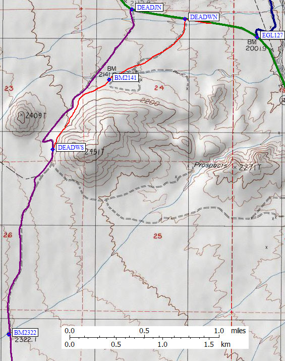
|
If you're approaching Deadman Pass from the south, go 1.6 miles north of Shoshone on Hwy 127 and turn left (west) turn onto Hwy 178 (waypoint 127178). 5.8 miles west on Hwy 178 there is a right (northeast) turn onto Greenwater Valley Road (waypoint GREENJ). Follow this road (later called Furnace Creek Wash Road) almost 16 miles to the southern Deadman Pass junction (waypoint DEADJS) at 3000'. Go roughly 5 miles northeast to the pass (waypoint DEADMP) and roughly another two miles down the other side to 3000' and the DPS Guide's 4WD trailhead (waypoint BRN4WD).
See the Overview map for context and connections to this map,
see this 2009 trip report for climbing details.
From the south (Shoshone):
From the north (Death Valley):
The Eagle trailhead area is a great place to camp, far enough from
the highway, no high clearance required, and a dramatic view of the
tilted layers on Eagle Mtn N. Pay attention to the wilderness stakes!
See the Overview map for context and connections to this map,
see this 2009 trip report for climbing details.
Shoshone (waypoint SHOSHN) is 56 miles north of Baker (waypoint BAKECA).
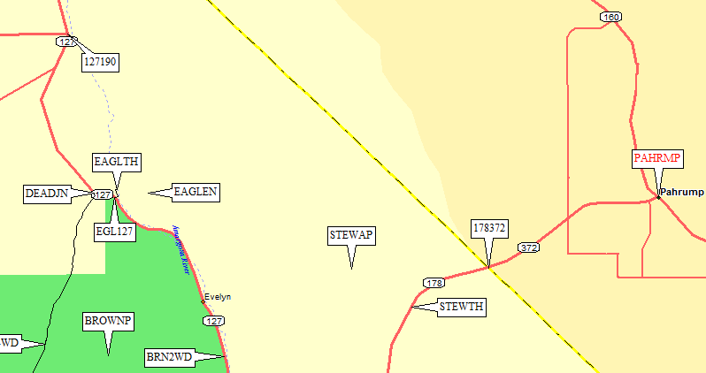
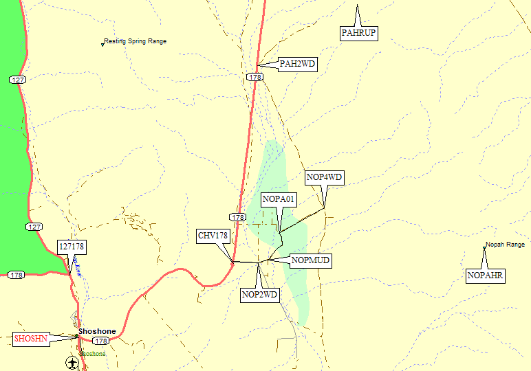
Take Hwy 178 east and then north from Shoshone, passing the Chicago Valley
turnoff for Nopah (waypoint CHV178) and the trailhead for Pahrump (waypoint PAH2WD).
15.7 miles from Shoshone, park on the shoulder (waypoint STEWTH) and walk NW
across the desert toward the peak.
This trailhead is 11.3 miles from the main intersection (waypoint PAHRMP)
in the town of Pahrump.
See the Overview map for context and connections to this map.
Shoshone (waypoint SHOSHN) is 56 miles north of Baker (waypoint BAKECA).
Take Hwy 178 east and then north from Shoshone, passing the Chicago Valley
turnoff for Nopah (waypoint CHV178). 10.6 miles from Shoshone, park on the
shoulder (waypoint PAH2WD) and walk NE up a faint dirt track to the peak.
This trailhead is 16.4 miles from the main intersection in the town of Pahrump.
See the Overview map for context and connections to this map,
see this 2009 trip report for climbing details.
Leave Hwy 178 at the large yellow sign for Chicago Valley (waypoint CHV178),
which is 5.4 miles from Shoshone (waypoint SHOSHN) or 21.6 miles from the
main intersection in downtown Pahrump (waypoint PAHRMP). Head due east
on an excellent dirt road which is unfortunately short. 0.6 miles from
the pavement (waypoint NOP2WD) the main road turns south, a smaller
road goes straight, and an even smaller road bends left along power lines.
Passenger cars should park at this intersection (waypoint NOP2WD) because
there is room here and mud flats lie ahead!
Continuing due east from this intersection, the road goes through a
stand of trees that could double as a witch's orchard in a horror
movie, then bends left (northeast) in a mud flat (waypoint NOPMUD).
Small rains might bring large changes to the road here, there are
springs uphill, and there are past DPS reports about capable 4WDs
with capable drivers getting stuck in the mud. This bend (NOPMUD,
0.3 mi from NOP2WD) is where climbers with 2WD vehicles who are
headed for the DPS Guide's Route B will leave the road.
4WD vehicles (in good weather), or climbers walking the road, can
continue northeast and then north to the junction at waypoint NOPA01.
Turn right (northeast) to a T intersection with another 4WD road
(waypoint NOP4WD) at Twelvemile Spring. This north-south 4WD road
apparently connects with the cross-country part of Route B (at
waypoint NOPB01) and there might be another way to get onto it
further south, but I haven't been on either road personally.
(Those who have knowledge are invited to improve this page by
sending details!)
See the Overview map for context and connections to this map,
see this 2009 trip report for climbing details.
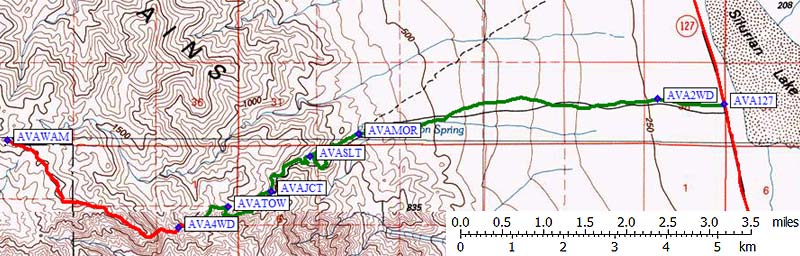
If you are approaching from I-15, exit at Baker (waypoint BAKECA) and take
Hwy 127 (aka Death Valley Road) north. Check your gas guage before you leave,
because the 4WD road to Avawatz will burn more fuel than you might guess.
It takes just over an hour to drive from the pavement (AVA127) to the trailhead (AVA4WD).
See the Overview map for context and connections to this map.
19.5 miles north of the freeway, you will NOT see the Mormon Springs Road
(the green line on this topo map), but it's there anyway (waypoint AVA127).
You can detect it as a small break in the berm on the west side of the road.
It's near, but just north of, a more visible dirt road leading east across
the dry Silurian Lake.
Not wanting to leave a car on Hwy 127, we kicked a little dirt into the
grader ditch and drove my passenger car 0.8 miles west to a flat spot
with an old fire ring (waypoint AVA2WD). You could camp here, but we
wanted an early start the next morning and wanted to finish the 4WD part
of the road. The grade steepens, the ruts deepen, the traction gets worse,
and in general the road is not suitable for passenger cars beyond AVA2WD.
I'm calling this the 2WD trailhead because it's off the main drag and
you can get here with any vehicle. But it's too far to walk from here!
High clearance 2WD's can get a bit further, but not enough further to
make the peak a reasonable dayhike.
Continue west up Mormon Springs Road to a sign pointing right to Mormon Springs
(waypoint 4WDSPR, 4.6 miles from the pavement). Keep straight/left here, on
what is now a nasty 4WD road with loose rocks and washouts. The road bends very
slightly south, still going mostly west, and enters the main canyon. After going
around a ridge (south, then north) the road goes southwest through a very narrow
slot (waypoint AVASLT, 5.6 miles from Hwy 127) where rockfall can change the
roadbed quickly. We had to move a few rocks, but the Jeep had no problems
beyond a bit of lurching and spinning. This was the worst traction on the road,
but not the most dangerous section!
6.6 miles from the pavement (waypoint AVAJCT) there is a junction with a very
vague road to the left. Stay on the main road which goes straight. There is
no 3-way fork as described in DPS Guide! 7.4 mi from the pavement the road
reaches the end of the canyon going west (waypoint AVACYN), and switches back
to climb northeast and then north out of the canyon. This grade is cut into
the canyon wall and has eroded badly in some places. It is narrow, slopes
toward the outside, is sometimes loose rocky and sometimes sand on hardpack,
and it has several erosion cuts filled in with loosely stacked rocks.
If you lose traction here, or drop a wheel over the edge, it's Game Over.
Enlarged Avawatz trailhead area, eastern portion of 4WD road and paved roads are on maps above.
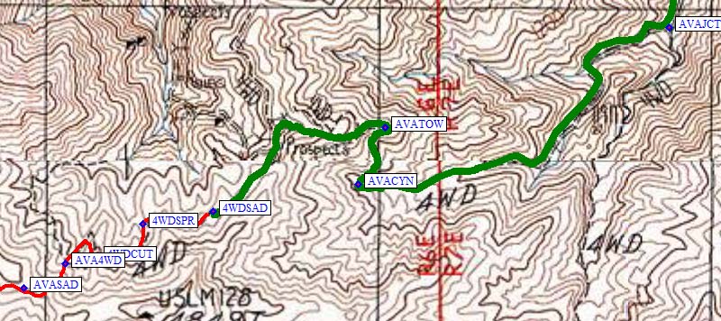
Once you get to the hairpin around a radio tower (waypoint AVATOW, 7.6 mi
from the highway), the road eases up. Bear left/straight to stay on top
of a knife edge ridge (don't drop down on right fork). Erosion here has
worn away both sides of the road, but at least you can split the difference
and not feel like you'll slide off the edge. Stay on top of the ridge as
long as you can, going west and then southwest while continuing to climb.
The road soon goes down sharply (waypoint 4WDSAD, 8 miles from the pavement).
We were worried about whether it was too rocky and loose to come back up,
and it was already dusk, so we stopped for the night at a spur ridge where
it was easy to turn around and flat enough to camp.
The drop from 4WDSAD isn't much elevation, but once again the road slopes
toward the edge and the traction is bad on large loose scree. We're not
sorry we stopped where we did, but if you're gung-ho you can drive another
0.4 miles to a better parking and camping area (waypoint AVA4WD). It took
us 10 minutes to walk there, and we spent more than that long deciding
whether to drive it. We saw no boulder blocking the road as reported by
a recent climber - maybe that was beyond where we left the 4WD road??
Halfway between waypoints 4WDSAD and AVA4WD there is another spur road
(waypoint 4WDSPR) which could be used to park more vehicles and which
offers flatter camping than 4WDSAD... but you've had to do the hard part
so you might as well drive to the 4WD trailhead. If you're walking,
you can cut the road's switchback between waypoints AVACUT and AVA4WD.
Waypoint AVA4WD appears to be the DPS's 4WD trailhead. The road goes on,
but this is the best place to leave it and climb southwest up a gully to
the ridge. If you follow the road further, the ridge is lower but the road
will drop and you'll have the same amount of gain with more mileage.
At waypoint AVASAD you can pick up a use trail going over the shallow
saddle from which you can see the gray end of the summit ridge.
See the Overview map for context and connections to this map,
see this 2009 trip report for climbing details.
If you are approaching from Tecopa, drive 1.7 miles east on the
Old Spanish Trail and turn left on Furnace Creek Rd (waypoint FURSPN).
3.5 miles from Tecopa you go past the China Date Ranch turnoff
(waypoint CHINRD). It's only 4 miles round trip to the ranch
(with its promise of cool date shakes) and the road goes through a pretty
cool canyon to get there. It's worth a side trip but they close at 5pm.
5 or 6 miles east of Tecopa, the pavement starts to break up and the
road becomes good gravel. About 10 miles from Tecopa (waypoint FURTAL)
Furnace Creek Road splits into Mesquite Valley (northeast) and
Smith Talc (southeast) roads. You want the right (southerly) fork.
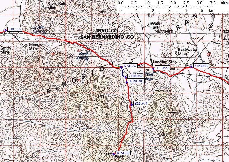
Smith Talc Road turns due east and follows a powerline as the terrain
steepens. There's an unmarked fork (waypoint EXCELS, 15.5 miles from Tecopa)
where you must stay left to keep on the main road. You're now on
Excelsior Mine Road, and it's very rough but still passable for
passenger cars up to the high point (waypoint KINGHP, 20 miles from Tecopa).
before you reach Tecopa Pass (waypoint TECPAS).
If you are approaching from I-15, exit at Cima Road. That road only goes
south, to the north it's called Excelsior Mine Road, but the freeway sign
only says Cima. 13 miles north on a good paved road there's a sign for
the Kingston Wilderness Area (waypoint KINGWB). Continue north and watch
out for deteriorating pavement that has huge and unexpected potholes.
After a cattle guard you will crest a rise, where the road gets worse
(now very deteriorated pavement) and worse (eventually there's no asphalt at all).
There is a Kingston Wash Limited Use Area sign (waypoint KINGLU) 22 miles
from the freeway. This is where the Mojave Heritage Trail 4WD road crosses
Excelsior Mine Road. You'll pass a campground (waypoint KINGCG) 27 miles
from I-15 - we didn't investigate it because we wanted to camp near the
trailhead and get an early start. It was hot in April!
You cross another cattle guard about where all pavement ends, a quarter mile
before Tecopa Pass (waypoint TECPAS, 29 miles from the freeway). Note that
this pass is NOT the high point of the road! After the pass you'll see a
small corral, then you'll cross the wash which is the approach to Kingston,
and continue UP to high point of road by the an abandoned mine (waypoint KINGHP).
Kingston 4WD and Tecopa Pass overview, more detailed map of trailhead 4WD road is below.
However you get to the high point (waypoint KINGHP) between Tecopa and Tecopa Pass,
you can leave the road at the high point an drive around north onto an
old mining platform for camping with a great overlook. There's a gated
mine road that used to go south from the high point, but it's totally washed out.
Enlarged Kingston trailhead area, context including Tecopa pass is above.
The 2WD trailhead is 0.2 miles east of the high point of the road (waypoint KING2W).
There's a gravel area to park, but it might be safer to leave cars in the camping
area near the high point of the road, since that is out of sight from traffic on
the road. Follow a bad 4WD road south from waypoint KING2W. This serious 4WD road,
which appears to wash out and get re-routed occasionally, will turn east, then south
(waypoint KINGW1), and then southwest past the road (waypoint KINGW2) which apparently
used to connect to KINGHP. It follows the gully which leads south to the saddle
(waypoint KINGW3) between the 2WD trailhead and the wash.
Bear left at the saddle (waypoint KINGW3, only 0.4 miles from Excelsior Mine Road)
and drop down into the main wash. We parked at waypoint KING4W (0.6 miles from the
main road) because rocks in road were getting pretty huge. If you want to crawl
over 100' of really tough rocks you can drive a few hundred yards further...
but I don't think it's worth the hassle. Driving to KING4W is worth it if you
have a 4WD, but you can easily do the peak from KING2W.
Wherever you park, DO NOT climb that steep hill on the 4WD road! Leave the
4WD track around waypoint KINGXC, since the best route in the wash stays low.
The least brush can be found on the west edge of the wash, at least in the beginning.
The brush is tall and sustained later on, and there are ticks in this area. I was warned,
but I missed it somehow. I don't think the tick actually bit me until during the drive
home. Consider bagging your clothes and stripping for a double-check later in the day.
Maybe when you head to Tecopa for a shower!
See the Overview map for context and connections to this map.
Getting to Tecopa:
And now your're in the beautiful town of Tecopa (waypoint TECOPA)!
By the way, showers are also available at the Furnace Creek Ranch,
in Death Valley, for $5. This includes use of the pool and showers
with no timer. The pool is located down the road to the right of
the registration building where you pay.
Useful Links:
Eagle Mtn N (DPS Eagle #2) - GPS Routes TECOPA TO FURNACE CK and EAGLE MTN 2 N
Shoshone (waypoint SHOSHN) is 56 miles north of Baker (waypoint BAKECA).
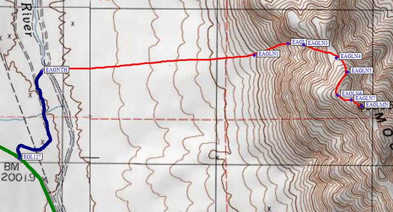
Go north from Shoshone on Hwy 127, past the trailhead for Brown
(waypoint BRN2WD). The highway will be aimed directly at the south end
of Eagle Mtn, with a gradual dogleg left around the peak. Where the road
turns more sharply west 19 miles from Shoshone (waypoint EGL127), turn
right (east) onto a dirt road. Follow the road north, east, and north
again to where a side road dead-ends on the bank of the Amargosa River
(waypoint EAGNTH).
Take Hwy 190 south and east from Furnace Creek (waypoint FURNCK) in Death Valley.
The road climbs from below sea level to over 3000' in about 18 miles. It then
drops 12 miles to Death Valley Junction (waypoint 127190) where Hwy 190 T's
into Hwy 127 near the Amargosa Opera House. Go south 8 more miles. The road
will be aimed almost directly at the west face of Eagle Mtn N, and when it
turns right (south) look for a dirt road (waypoint EGL127). Follow the road
north, east, and north again to where a side road dead-ends on the bank of
the Amargosa River (waypoint EAGNTH).
Stewart Point - GPS Route STEWART PT
Pahrump Point - GPS Routes FURNACE CK TO PAHRUMP and PAHRUMP PT
Nopah Range - GPS Routes Routes FURNACE CK TO PAHRUMP,
NOPAH RANGE 2WD and NOPAH RANGE 4WD
Avawatz Mtn - GPS Routes TECOPA TO FREEWAY and AVAWATZ
Kingston Peak - GPS Routes TECOPA TO FREEWAY and KINGSTON
(The road's high point, KINGHP, is not labeled above because it is too close to KING2W.)
Tecopa Attractions - GPS Routes TECOPA TO FREEWAY and TECOPA ATTRACTIONS
Just west of Tecopa, it intersects Hwy 127 (waypoint TEC127).
Just east of Tecopa it intersects Furnace Creek Road (waypoint FURSPN).