Mt Stirling
Revised May 2010 - please send updates to the webmaster
The Spring Mountains are west of Las Vegas, and mostly encircled by Hwy 160 and Hwy 95. This page only has details of Potosi Mtn, the southernmost DPS List peak. There are links above for the other five peaks (Potosi, Bridge, Charleston, Mummy, McFarland).
Here is a road map for all the Spring Mountains peaks. Below are details for Mt Stirling.
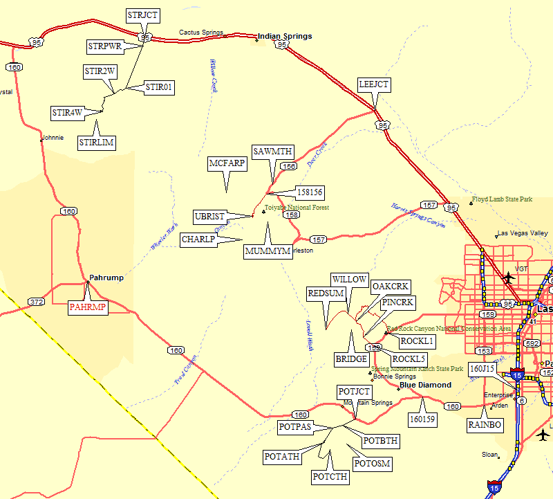
Forest Service Road 553 is marked by a yellow T-intersection sign with a brown sign saying National Forest Access (waypoint STRJCT). Hwy 95 is 4-lane here, so this is a significant intersection... roughly 54 miles northwest on Hwy 95 from downtown Las Vegas, or about 11 miles west of Indian Springs, or 14.7 miles east of Hwy 160. Take FS 553 south across a cattle guard and under a power line (waypoint STRPWR), and just keep going until you reach an intersection 5.8 miles from the pavement (waypoint STIR01 at 4.9k). This part of the road is OK for passenger cars.
|
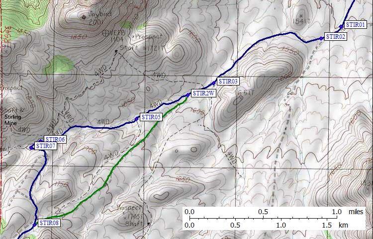
Go straight at STIR01, after which the road bends a bit to the right
and enters a wash. In 2010 there was loose gravel in that wash. Beware!
Passenger cars may want to stop at STIR01. A short rise out of the wash
(waypoint STIR02) gets you back on good road again.
In the wash there is an easy-to-miss
junction with another road that stays in the wash. You want to head west,
then southwest to another intersection 6.9 miles from the pavement
(waypoint STIR03).
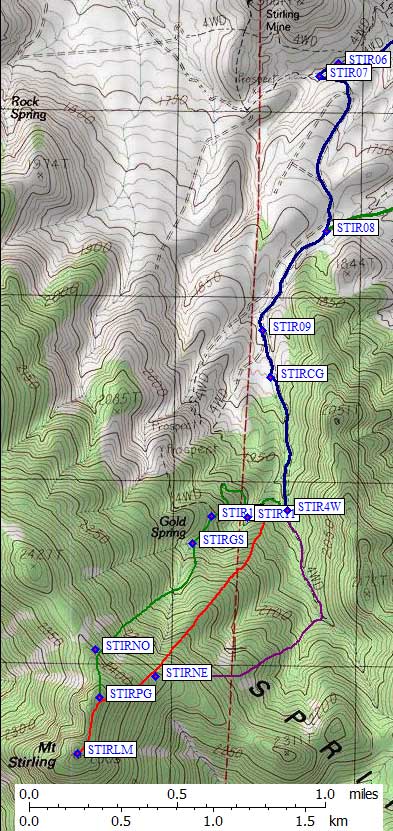
Stay straight/right 0.2 more miles to a more important intersection (STIR2W). Passenger cars should park here, high-clearance 2WD might make it further. I'm calling this the 2WD trailhead (at 5.2k). 50 yards beyond this intersection is the first of many shade trees where you might want to camp. It is entirely feasible to climb Stirling from the 2WD trailhead. The blue line on the map is the way we drove out, and it's far preferable to the green line which is the DPS Guide route we drove in on. At the STIR2W intersection, 7 miles from the pavement, go straight/right on Road 553. (The left fork, Road 592, has one section requiring high articulation to avoid teeter-tottering on two wheels.) Stay right/straight again 0.4 miles later (waypoint STIR05) on an unmarked road (the left turn was marked 553B, but don't go that way). 8.1 miles from the pavement (waypoint STIR06) stay straight/left where Road 553 makes a hard right turn. Cross the wash (waypoint STIR07) and turn left (east), then climb a short steep uphill section, above which the road turns south again and is somewhat rocky but not particularly high clearance or challenging. Stay left/straight/south on Road 591 at two more forks until you merge with Road 592 (the DPS Guide route) 8.9 miles from the pavement (waypoint STIR08). (This will be an important left fork on the way back, with a slight uphill section on the way out.) The road now hugs the west side of a ridge while going south to the trailhead. Ignore all forks or junctions to the right, just keep going south. 9.5 miles from the pavement, at 6.1k, there is nice camping and a loop to turn around (waypoint STIRCG). There is no reason to park here unless you want to camp or have a large group. Beyond that the road actually improves greatly, and continues to at least 6.7k although parking can be difficult. 9.9 miles from the pavement is an intersection at 6.4k which I'm calling the 4WD trailhead (waypoint STIR4W). I believe this is the best place to get on the northeast ridge of Stirling (waypoint STIRNE) and follow the red line on the map. |
|
Useful Links: