Potosi Mountain
Revised May 2010 - please send updates to the webmaster
The Spring Mountains are west of Las Vegas, and mostly encircled by Hwy 160 and Hwy 95. This page only has details of Potosi Mtn, the southernmost DPS List peak. There are links above for the other five peaks (Stirling, Bridge, Charleston, Mummy, McFarland).
Here is a road map for all the Spring Mountains peaks. Below are details for Potosi Mtn.
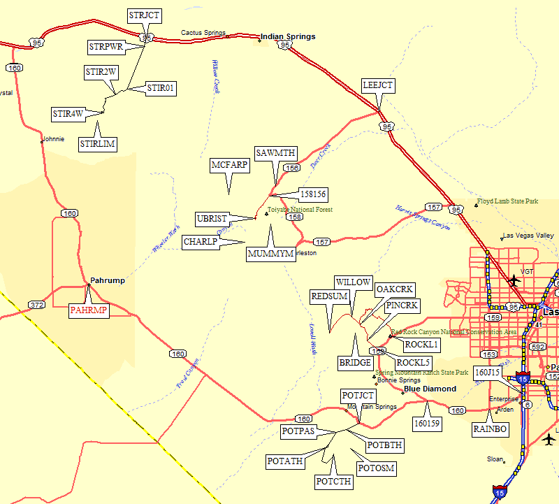
Take the Hwy 160 exit from I-15 south of Las Vegas (waypoint 160J15), heading west toward Blue Diamond. Continue west on Hwy 160 past the Hwy 159 junction to Blue Diamond (waypoint 160159). 18.5 miles from the freeway, turn left (southwest) on a dirt road (waypoint POTJCT). If you reach Mountain Springs Summit, you've gone 1.5 miles too far!
We didn't investigate the DPS Guide Route B trailhead (probably at or near waypoint POTBTH), which apparently leads you to a powerline and on to the saddle where routes A and C join (waypoint POTABC).
Passenger cars should stop 2.6 miles from Hwy 160 at Potosi Pass (waypoint POTPAS, 1.6k) where there is a gravel parking area. The road goes down Potosi Wash from here and gets very rough. There are plenty of No Trespassing and other We Don't Want You Here signs, which we assumed were for the land beside the road and not for vehicles on the road itself. 2WD with high clearance will be OK to Potosi Springs (waypoint POTSPR, 4.2 miles from Hwy 160) where there are several road forks. I think the left fork leads you to Route A but we didn't investigate.
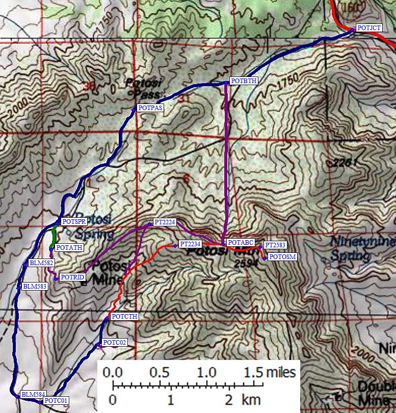
We took the right fork at Potosi Springs (waypoint POTSPR), which goes by a fenced house, to access DPS Guide Route C. About half a mile past the springs, there were BLM signs for Road 582 and 582C (waypoint BLM582) where we stayed right. Then a quarter mile further we stayed left on 582 at the BLM sign for Road 583 (waypoint BLM583). All this just kept us on the main road that continues south around of the ridge containing the Potosi Mine.
The low point of this road is 6.2 miles from Hwy 160, a wash at 5k, where it turns east and climbs 0.1 miles sharply to a sign for BLM Road 584 (waypoint BLM584) We again stayed left (straight) on 582. A quarter mile later we turned left onto BLM Road 584A at 5.2k (waypoint POTC01, 6.6 miles from Hwy 160). This turn marks the south tip of the Potosi Mine ridge, and our road now climbed into the canyon east of that ridge. We were expecting a sign for some springs (based on the Zdon book) but we saw nothing. The road progressively gets worse, but high clearance 2WD can probably get this far, if not all the way to the trailhead.
Stay straight (left) at waypoint POTC02, where a tempting road appears to head directly for the peak but doesn't go very far. The correct road braids in several places, so it looks less well travelled than what you've been on, but it continues basically north to 5.7k where there is a turnaround and the road suddenly gets much worse (waypoint POTCTH). We considered this the Route C trailhead, at 5.7k and 7.8 miles from Hwy 160.
Useful Links: