Cartago Canal Trailhead
Revised 11 Jun 2012 - please send updates to the webmaster
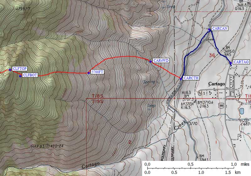
Turn northwest from Hwy 395 just north of "downtown" Cartago (waypoint CARTAG). Cross the aqueduct (canal) on an un-gated bridge (waypoint CARCAN) and turn south along the canal on a dirt road. Regular passenger cars can park alongside the L.A. aquaduct just north of a narrow, sandy, unmarked (and now closed) 4WD road that serves as the Cartago Canal trailhead at 3700' (waypoint CARCTH).
In 2006, 4WD vehicles could drive west up to the some unsigned wooden posts that apparently marked the end of the 4WD road (waypoint CAR4WD, at 4200'). As of 2010 there are were big boulders blocking the 4WD dirt road. Instead of driving the last 0.3 miles to the 'trailhead' as described in Daryn's trip report, you can only get 200 feet up this road to the wilderness boundary signs and boulders.
Start by walking up the old road, then through the sand and the sage brush until you get to a higher region of joshua trees, then gnarled cedars, and then up to pinyon pines. Stay on use trail (on the broad ridge) until about 5700', then cross left into a drainage (waypoint 5700ft) for easier walking. Above this point it's tempting to continue drifting left, but if you go to far south you'll end up in nasty brush and slabs. It's far better to cross the cliff band between waypoints CLFBOT and CLFTOP and stay right of the poorly defined ridge for the best walking.
Campsites can be found above 8200', where you cross the cliff band, but there may be no water if there's no snow to melt. We found a seasonal stream in May of a high snow year at waypoint STREAM (10k and near the summit) and there may be other sources of water on the summit plateau, but don't count on them in late summer! The climbing is reasonable if you pass between the bumps at 9900' (waypoint CSADDL) and head to the plateau before turning south to Cartago Peak (which is not marked on any map). It's only about 4 miles total to Cartago Peak (waypoint CARTAP, at 10480').
Useful Links: