Sequoia and Kings Canyon National Parks
Revised 23 Oct 2014 - please send updates to the webmaster
Sequoia and Kings Canyon are large parks, managed jointly. This file addresses only trailheads on the western side of the parks. Generally, the northern approach to the trailheads below is faster road, but those coming from Southern California generally use the shorter southern approach.
Waypoints for both northern and southern approaches are plotted below - scroll down below the map for explanatory text. Click on the trailhead links above for additional information and further waypoints.
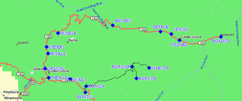
For waypoints along the southern approach, from Hwy 99 through Visalia, see the Three Rivers page. As you travel northeast from Visalia on Hwy 198, now entirely freeway through town, you come to the Mountain Home turnoff (waypoint YOKOHL), go around Lake Kaweah (a reservoir that's often empty in the fall), and past the South Fork turnoff (waypoint SFORKD) which is about 0.4 miles before Three Rivers (waypoint 3RIVER). About 4 miles beyond Three Rivers you reach waypoint 198MIN, the turnoff for Mineral King. Both Hwy 198 and the Mineral King road have seasonal snow closures.
For waypoints along the northern approach, from Hwy 99 through Fresno, see The Wye page. As you travel east from Fresno on Hwy 180, you encounter a named intersection where Hwy 198 tees off Hwy 180 (waypoint THEWYE). The Wye is where you can turn north for Cedar Grove or south for Lodgepole.
The rest of this file describes the map below from south to north.
Hwy 198 begins to climb steeply when it leaves the Middle Fork
of the Kaweah River at waypoint MIDFRK. The first climber's trailhead
you come to when approaching from the south is Crescent Meadow
(waypoint CRSCNT is where you turn off Hwy 198, the trailhead is at waypoint CRSCNP).
Crescent Meadow is a good entry point for the High Sierra Trail through Bearpaw
Meadow and Hamilton Lakes to Kaweah Gap.
Continuing north on Hwy 198 about 3 miles, you reach the
Wolverton turnoff. There is a small
ski lift here, but I've never seen it in operation. This trailhead
(waypoint WOLVET is the turnoff, WOLVEP
is the parking lot) leads
you to popular year-round destinations like the ski hut at Pear Lake
and Alta Peak. Hwy 198 is plowed to Wolverton from the north all year,
but is closed to the south some months of the winter.
NOTE: As of summer 2014, Wolverton was the non-handicap parking area for Sherman Tree,
with all parking at Sherman reserved for the handicapped. A shuttle from Wolverton
takes regular people to the tree.
Lodgepole is the WESTERN Twin Lakes trailhead, which goes to Silliman via Cahoon Gap,
not to be confused with the Twin Lakes near Bridgeport on the east side.
Less than 2 miles north of Wolverton is Lodgepole,
the main destination for tourists. Turn east from Hwy 198 at waypoint LODGET and
park at waypoint LODGEP. Parking is free all year, and the lot is plowed in the
winter. There are public access bear boxes at the trailhead, and cars not using
them are broken into as early as March. There are many facilities near Lodgepole,
but they are not all open at all times of the year. In the summer, you can find
a gas station, restaurant, public showers, convenience store, visitor center,
and all the things that attract busses and motor homes.
NOTE: There used to be a ranger station at Lodgepole
(waypoint LODGER) where self-issue permits could be
obtained in the winter and is where reserved permits were picked up in the summer.
In June 2014 the Lodgepole Ranger Station was closed and self-issue permits were
outside the Giant Forest Museum.
There used to be a restaraunt and laundromat at Stoney Creek (waypoint STONEY),
but I haven't been there in a while and I'm not sure the laundry is still
functioning.
Further north is the turnoff for Marvin Pass and Rowell Meadow
(waypoint ROWL01), two little-known trailheads providing very efficient access to
Roaring River and Cloud Canyon. (Follow that link for a detailed trailhead page.)
Permits are usually available without reservations
at the Grant Grove ranger station (waypoint GRANTG).
About 7 miles north of the Rowell Meadow turnoff, Hwy 198 ends at Hwy 180
(waypoint THEWYE). The Wye is a named
intersection where people coming from Fresno turn north for Cedar Grove and
south for Lodgepole. Points south (on Hwy 198) are described above.
Leaving The Wye (waypoint THEWYE) toward Cedar Grove (on Hwy 180), it's
only about 1.5 miles to the ranger station at Grant Grove (waypoint GRANTG).
Here you can find a filling station, a good restaurant, a gift shop, and
a small visitor center. Permits can be picked up here, but call ahead to
make sure they'll issue one for your choice of trailheads.
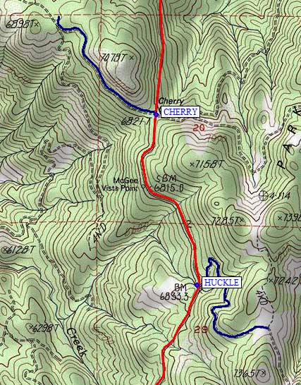
There are three forest service roads leaving Hwy 180
near McGee/Cherry which some climbers use to get away from the highway
for the night without paying a ridiculous campground fee. The first
road is unmarked (waypoint HUCKLE) and somewhat rough but still OK
for passenger cars - it leads east to Huckleberry Meadow eventually.
Shortly after that you pass the McGee Vista Point and then cross
Cherry Gap (waypoint CHERRY) where two marked (and much better) roads
lead east and west. The western road leads to a flat area about 3/4 mile
from the highway. If you're not sure where this is, load the
waypoints into your GPS and follow the arrow!
Another spot
is about 8 miles south from The Wye (near waypoint ROWL01), as described
on the Rowell Meadow and Marvin Pass trailhead page.
These two trailheads, for which you leave Hwy 198 at waypoint ROWL01, are described separately
on the Rowell Meadow and Marvin Pass trailhead page.
Either of these trailheads will get you to Roaring River in less than a day, with thousands
of feet less elevation gain than starting at Cedar Grove and going over Avalanche Pass.
North of Grant Grove and The Wye (waypoint THEWYE),
Hwy 180 climbs to about 6800' and crosses Hoist Ridge at Cherry Gap (waypoint CHERRY).
There is a map and description of forest roads where you can
camp for free at the top of this page.
Continue down Hwy 180, past the Hume Lake turnoff (waypoint HUMELK)
and eventually you reach the Kings River at about 3000'. This road
is closed in the winter, but often bare once you get over Cherry Gap
and lose elevation. (Some people have pushed mountain bikes over the
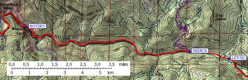
snow so they could ride along the Kings in early spring.) Boyden Cave
(waypoint BOYDEN) is a rare sightseeing opportunity since caves are
not common in granite and granite predominates in the Sierra Nevada.
The road goes past trailheads at Deer Cove Creek
(waypoint DEERCK) and Lewis Creek (waypoint LEWISC).
The Deer Cove Creek trail (which does NOT start quite where the map shows it)
is less wet than Lewis Creek (which has many stream crossings), and it's outside
the park. No permit is needed to enter at Deer Cove, but in 2010 a sign at the
trailhead indicated you need a Forest Service permit to carry a portable camp
stove, much less have a campfire! Also, you will enter Sequoia/Kings National
Park before you reach any peaks, and you need a permit to spend the night in
the park. For details of the Deer Cove Creek trail (which does NOT exactly
match the line on the USGS 7.5' topos), and for how to find the Frypan Meadow
bear box, see my 2010 trip report.
The Deer Cove trailhead is in Sequoia National Forest and does not
require a permit for entry into the Monarch Wilderness where it is
located. A Campfire Permit is, however, required for both campfires
and portable stove use. Such a permit can be issued by any Forest
Service office and also can be self-issued on-line. For details on
both wilderness permits for this area and campfire permits for
anywhere you do not have a wilderness permit see the Sequoia National Forest
Wilderness Permit Aplication Page.
Since Frypan Meadow is in the National Park and requires a permit
(according to the sign at our camp), the issue arises how to get such
a permit. The Sequoia National Forest wilderness permit application
form says "Permits for trips that begin in National Forest wilderness
and continue into adjacent National Park must must be obtained from
the Forest Service." The permit application is on-line and can be
mailed or FAXed to Kernville or Springville. Incidentally Ron Karpel
was able to get a permit in 1998 for Deer Cove Trail camping at Frypan
Meadow from the park service at Road's End.
Frypan Meadow is a delightful and handy spot to camp for trips
incudling the climbs of both Kennedy and Harrington. If the target is
just Harrington, one can camp at Grizzly Lakes and avoid a permit for
National Park entry, though the approach to camp is considerable
longer. Only a campfire permit is needed in that case.
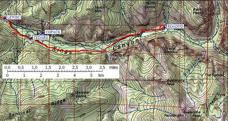
Continue east and you will reach Cedar Grove Village (turn northeast at
waypoint CEDARG) where you can buy dinner or ice cream and fill up on
overpriced gas. The bargain at the Village is showers: $2.50 for 10 minutes
in a private room as of 2004, buy tokens at the general store during their
regular hours (8am to 7pm ??). It seems that the shower building sinks
are available free and 24 hours a day, but don't count on that. The
showers are just north of the general store but before you get to
the Cedar Grove pack station (CGPACK).
Go all the way to the trailhead parking at Roads End
(waypoint ROADND) to pick up permits from the special kiosk rangers who sometimes
insist every person in your group must be present to hear the bear box lecture.
Once for each group. (Expensive permits - $15/group even
if you're alone. It's not a reservation fee. Even walk-ups pay.)
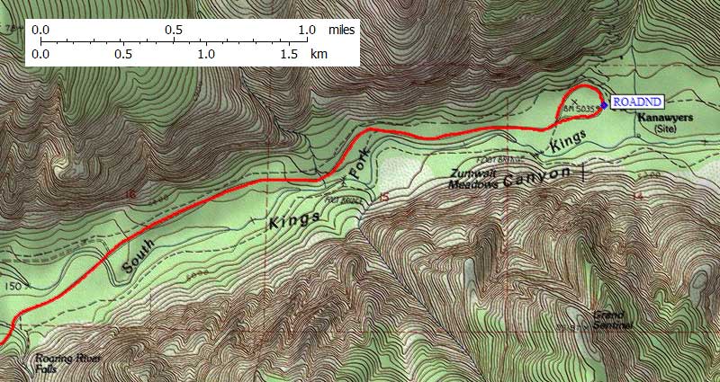
There are actually two parking areas on the paved loop at Roads End (waypoint ROADND),
one for Copper Creek (north) and one for the Kings River and Bubbs Creek (east),
but they are both served by the permit kiosk at waypoint ROADND. The kiosk is
at the trailhead for Bubbs and you have to drive or walk to the other lot for Copper Creek.
In 2004 I was told that the southern lot is for day use only even though there is
no sign, and cars parked in the northern lot should have parking passes issued by the
ranger kiosk. You must park on pavement here. If even one tire is
even partly on sand, you'll get a warning or a ticket.
There are bear boxes for overnight food storage in both the
day use lot and the
backpacker lot.
The Kings River trail leads to places like Kearsarge Pass, Paradise Valley,
and The Sphinx, with the first two miles wide and sandy like a beach.
The Copper Creek trail is the switchbacks going north on the map below.
Useful Links:
Free camping in the National Forest
About 5 miles north of The Wye,
Hwy 180 climbs to about 6800' and crosses Hoist Ridge at
Cherry Gap (waypoint CHERRY) near the McGee Vista Point. Here you are
in National Forest, no longer in the National Park, so you can camp
anywhere legally.
Louise Wholey adds, as of June 2010
Here is what I have learned on the permit situation: