Hope Valley Trailheads
Revised 9 Jul 2021 - please send updates to the webmaster
GENERAL NOTES:
Note that Luther Pass (waypoint LUTHER) and the Big Meadow trailhead for the Tahoe Rim Trail (waypoint BIGMRT) are summer-only parking areas! Both are signed strictly no parking in the winter, and vehicles blocking snow plows will be towed. I'm not sure if you'll be towed when they're not plowing, but I wouldn't risk it!
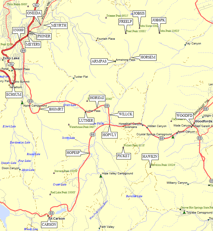
The official Hope Valley Sno-Park (waypoint HOPESP) is just over 2 miles west from the intersection of Hwy 89 and Hwy 88 (waypoint HOPVLY). It is often loaded with snowmobile trailers and is on the wrong side of Carson Creek (which runs all winter) if you're headed for Hawkins or Pickett.
Area Map - scroll down for topo map and detailed directions:
|
Skiers and snowshoers will find a quieter (and completely free -
no Sno-Park permit required) parking lot immediately south of
the intersection between Hwy 88 and Hwy 89 (waypoint BURNLK).
In the summer this is the Burnside Lake Road, but it's gated right
at a plowed parking lot in the winter. Trails are not groomed but
are heavily travelled. Overnight parking is allowed but not common.
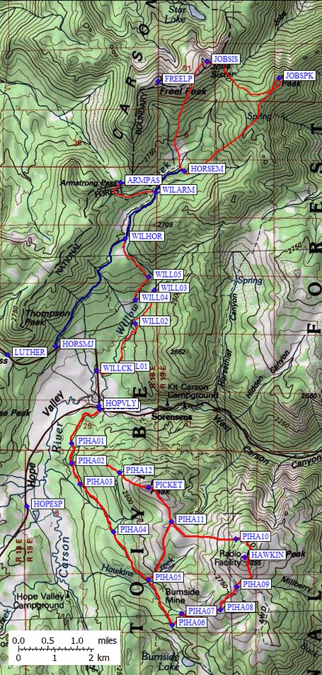
If you are headed for Freel or Jobs in the winter, park at Hope Valley (waypoint BURNLK) and walk up Hwy 89 to either Willow Creek (waypoint WILLCK) or the Horse Meadow road (waypoint HORSMJ). Note that Horse Meadow Road is open to snowmobiles (don't block the entrance). It has a gate near Hwy 89 which was open in mid-December. Summer hikers can drive up the (dirt) Horse Meadow road, and winter hikers may choose to go this way because Willow Creek isn't packed down. The main advantage of going this way is shorter, but less gain and a packed trail may not balance the hassle of motorized users whizzing by. Beren Erchamion says: The easiest way to climb Freel [in the summer] is to drive in on the dirt road just south of Luther Pass on Hwy 89 [waypoints HORSMJ to WILARM, or maybe all the way to HORSEM]. It was a passenger car drive in when I went in on it, but you should call the Toiyabe NF for information on current road conditions. There's a whose slew of primitive campsites at the end of the road, about 3 miles in, and there's no charge for any of them. If you go to the saddle just north of campsites, you'll end up on the Tahoe Rim Trail, which goes right up to the top of the peak. The Willow Creek trailhead is a private road through a wildlife preserve. Don't block the entrance because people with a key to the locked gate WERE driving on it in mid-December. Take care with each intersection, because long-distance views are hard to come by and it's easy to get turned around in the trees. As you follow the creek up toward its major fork, you will see private land signs again. In December I simply turned uphill (west across the creek) and climbed up the shoulder to waypoint WILHOR where I joined the packed snowmobile track toward Horse Meadow. In the summer there should be a trail (which I have traced in red) but most people will probably take the Horse Meadow road in summer. The big advantage of going this way in the winter is avoiding the snowmobiles! |
|
Useful Links: