Western States Climbers (WSC)
Qualifying Peak List
Hosted for WSC on Climber.Org
Purpose: To give peak climbers the opportunity to climb and explore
a variety of mountain ranges throughout California, the Great Basin, and
Southern Oregon.
Last update September 2022. Please send any comments on this version of the Coastal Peak List to the WSC Executive Committee.
Note: while the list now has limited
coverage in the Western States, it could be expanded to other areas if
knowledgeable climbers identify an appropriate set of worthy peaks to climb
elsewhere within the west.
This project is under consideration by the Executive Committee.
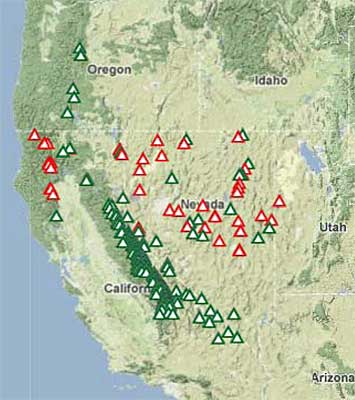
Click for a live map of peaks on this list:
|
A few related lists of worthy objectives are:
Contributors
- Gene Markley and other members of the former Northern Alpine Section compiled
the original hardcopy version of this peak list.
- Pete Yamagata and other members of the former Peak and Gorge Section updated the original
list.
- Former member John Sarna designed webpages to make this
list generally available to the public after the dissolution of these Sections,
which Steve Eckert later incorporated into Climber.Org.
|
Warning:
Hiking and climbing conditions do change, and some information given here
is subjective. The Western States Climbers do not accept responsibility
for outdated or incorrect information. Please help future climbers by sending
corrections to the WSC Executive Committee.
Go straight to the list of WSC peaks
See the explanation of symbols in front of the peaks
See the emblem requirements for significant accomplishments in climbing peaks on this list
See those who we recognize for their accomplishments in climbing peaks on this list
The WSC Peaks are organized into the following areas
Sierra Nevada:
1: Far Southern Area
2: Great Western Divide
3: WhitneyArea
4: Kings Kern Divide
5: Baxter Pass to Mather Pass
6: Palisades Area
7: Evolution Area
8: HumphreysBasin
9: Pine Creek to Ritter Range
10: Ritter Range to Tioga Pass
11: Clark Range Vicinity
12: Tioga to Sonora Pass
13: Sonora to Carson Pass
14: Carson Pass to Far North
Other mountain ranges in California:
15. Cascade Range
16-21. Coastal Ranges
22-25. Eastern Desert Ranges
Peaks in other States:
26-29. Nevada
30. Oregon
31. Utah
Peaks have been chosen to be within a days drive of cities in Northern
California and Western Nevada.
Explanation of Symbols
The peaks are classified as Star (*), Emblem (x), and Mountaineer Peaks
(o), according to their elevation, technical difficulty, dominance of an
area, view, and inaccessibility. Star peaks will generally be dominant
in setting, have exceptional views, and often will be more technically
difficult to climb. Emblem peaks will be somewhat less difficult and may
be secondary peaks in the setting. The Mountaineer peaks are generally
workout peaks.
The Western States Climbers will recognize significant accomplishments
in climbing peaks on this list by inclusion in the WSC
Internet Recognition List of Emblem Holders and List Finishers..
Emblem status is conferred on those
climbers who have reached the summits of:
-
15 peaks -- all Star peaks
-
20 peaks -- 10 Star peaks and any other 10 on the list
-
25 peaks -- any 25 peaks on the list
-
(Youth only, age 20 or below) 10 peaks -- 5 Star peaks, 3 Emblem peaks,
and any other 2 peaks
-
(Youth only, age 20 or below) 15 peaks -- any 15 peaks on the list
Super-Emblem status is conferred on those
climbers who have reached the summits of:
-
50 peaks -- 30 Star peaks and any other 20 peaks on the list with at least
one peak from each of 15 of the geographic subsections
-
65 peaks -- any 65 peaks on the list with at least one peak from each of
10 of the geographic subsections
List completion status will be conferred on those climbers who have reached
the summits of all peaks on this list.
The process for obtaining recognition is specified under "process"
on the WSC Internet Recognition List.
California Peaks
This list of peaks is organized into areas and generally ordered from south
to north.
Sierra Nevada
1. Far Southern Area
-
* Olancha Peak (12,123')
-
x North Maggie Mtn. (10,235')
-
x Kern Peak (11,510')
2. Great Western Divide
-
x Florence Peak (12,432')
-
x Sawtooth Peak (12,343')
-
* Mt. Kaweah (13,802')
-
x Red Kaweah (13,754')
-
* Black Kaweah (13,765')
-
* Triple Divide Peak (12,364'')
-
* Milestone Mtn. (13,461')
-
* Midway Mtn. (13,666')
-
* Table Mtn. (13,630')
-
* Thunder Mtn. (13,588')
-
* Mt. Brewer (13,570')
-
x North Guard (13,327')
3. Whitney Area
-
* Mt. Langley (14,042')
-
x Mt. Pickering (13,485')
-
* Mt. Corcoran (13,733')
-
* Mt. LeConte (13,960')
-
* Mt. McAdie (13,720')
-
x Mt. Mallory (13,850')
-
x Mt. Irvine (13,770')
-
x Mt. Muir (14,015'')
-
* Mt. Whitney (14,49')
-
x Mt. Hale (13,493')
-
* Mt. Russell (14,086')
-
x Mt. Carillion (13,552')
-
* Mt. Barnard (13,990')
-
x Trojan Peak (13,950')
-
* Mt. Tyndall (14,018')
-
* Mt. Williamson (14,375')
4. Kings Kern Divide
-
* Junction Peak (13,888')
-
* Mt. Keith (13,977')
-
x Mt. Stanford (13,963')
-
* Mt. Ericsson (13,608')
-
* Deerhorn Mtn. (13,265'')
-
* East Vidette (12,350')
-
* University Peak (13,632')
-
* Mt. Gardiner (12,907')
-
x Mt. Cotter (12,721')
-
* Mt. Clarence King (12,905')
5. Baxter Pass to Mather Pass
-
* Arrow Peak (12,958')
-
x Mt. Pinchot (13,495')
-
* Mt. Ruskin (12,920')
-
* Tehipite Dome (7,708'')
-
x Cardinal Mtn. (13,397')
-
* Split Mtn. (14,058')
-
x Mt. Prater (13,329')
-
x Mt. Bolton Brown (13,538')
-
x Birch Mtn. (13,665')
6. Palisades Area
-
* Devils Crags (12,600')
-
x The Thumb (13,388')
-
x Disappointment Peak (13,917')
-
* Middle Palisade (14,040')
-
* Norman Clyde Peak (13,956')
-
x Mt. Gayley (13,510')
-
x Temple Crag (12,999')
-
* Mt. Sill (14,162')
-
* Polemonium Peak (14,000')
-
* North Palisade (14,242')
-
* Thunderbolt Peak (14,040')
-
x Mt. Winchell (13,768')
-
* Mt. Agassiz (13,891')
7. Evolution Area
-
x Mt. Goode (13,092')
-
x Mt. Johnson (12,868')
-
x Mt. Gilbert (13,103')
-
* Mt. Thompson (13,480')
-
x Mt. Powell (13,400')
-
x Mt. Wallace (13,377')
-
* Mt. Haeckel (13,435')
-
x Mt. Fiske (13,524')
-
x Mt. Huxley (13,117')
-
* Mt. Darwin (13,830')
-
x Mt. Mendel (13,691')
-
* Mt. McDuffie (13,271')
-
x Scylla (12,939')
-
* Charybdis (13,091')
-
x Black Giant (13,330')
-
* Mt. Goddard (13,568')
-
* The Hermit (12,360')
-
x Mt. Lamarck (13,417')
8. Humphreys Basin
-
x Mt. Goethe (13,240')
-
x Mt. Emerson (13,225')
-
* Mt. Humphreys (13,986')
-
x Mt. Hooper (12,349')
-
* Seven Gables (13,075')
-
x Basin Mtn. (13,240')
-
* Mt. Tom (13,652')
9. Pine Creek to Ritter Range
-
x Mt. Julius Caesar (13,196')
-
* Bear Creek Spire (13,713')
-
x Mt. Dade (13,600')
-
* Mt. Abbot (13,715')
-
x Mt. Mills (13,468')
-
* Mt. Gabb (13,711')
-
x Mt. Hilgard (13,361')
-
x Mt. Morgan (13,748')
-
x Red and White Mtn. (12,850')
-
* Red Slate Mtn. (13,163')
-
x Mt. Baldwin (12,614')
-
* Mt. Morrison (12,268')
-
x Bloody Mtn. (12,544')
-
o Mt. Laurel (11,812')
10. Ritter Range to Tioga Pass
-
x Iron Mtn. (11,149')
-
* Clyde Minaret (12,281')
-
* Mt. Ritter (13,157')
-
x Banner Peak (12,945')
-
o San Joaquin Mtn. (11,600')
-
x Electra Peak (12,442')
-
x Rodgers Peak (12,978')
-
* Mt. Lyell (13,114')
-
x Mt. Maclure (12,988')
-
x Mt. Florence (12,561')
-
o Vogelsang Peak (11,516')
-
x Koip Peak (12,979')
-
x Kuna Peak (12,547')
-
x Mt. Gibbs (12,764')
-
* Mt. Dana (13,053')
-
x Unicorn Peak (10,840')
-
* Cathedral Peak (10,940')
11. Clark Range Vicinity
-
x Triple Divide Peak (11,607')
-
* Merced Peak (11,726')
-
x Red Peak (11,699')
-
x Gray Peak (11,574')
-
* Mt. Clark (11,522')
-
* Mt. Starr King (9,092')
-
x Half Dome (8,842')
-
x Clouds Rest (9,926')
12. Tioga to Sonora Pass
-
o Mt. Hoffman (10,850')
-
* Mt. Conness (12,590')
-
x North Peak (12,242')
-
x Mt. Warren (12,327')
-
x Petite Peak (10,788')
-
x Volunteer Peak (10,497')
-
x Piute Peak (10,541')
-
x Excelsior Mtn. (12,446')
-
o Camiaca Peak (11,739')
-
x Dunderberg Peak (12,374')
-
o Virginia Peak (12,001')
-
* Twin Peaks (12,308')
-
* Matterhorn Peak (12,264')
-
* Whorl Mtn. (12,029')
-
x Cleaver Peak (11,761')
-
x Blacksmith Peak (11,760')
-
o Eocene Peak (11,581')
-
* Tower Peak (11,755')
-
x Forsythe Peak (11,180')
-
x Blackhawk Mtn. (10,348')
-
x Leavitt Peak (11,570')
13. Sonora to Carson Pass
-
o Sonora Peak (11,462')
-
x Stanislaus Peak (11,220')
-
o White Mtn. (11,398')
-
o Wells Peak (10,833')
-
o Lost Cannon Peak (11,099')
-
o Fish Valley Peak (10,571')
-
* Whitecliff Peak (10,833')
-
o Antelope Peak (10,241')
-
x Disaster Peak (10,047')
-
o Mineral Mtn. (8,964')
-
* Highland Peak (10,955')
-
x Silver Peak (10,800')
-
x Reynolds pk. (9,690')
-
o Raymond pk. (10,011')
-
x Jeff Davis Peak (8,990')
-
o Markleeville Peak (9,417')
-
* Mokelumne Peak (9,332')
-
x Round Top Peak (10,380')
-
o Hawkins Peak (10,023')
14. Carson Pass to Far North
-
* Freel Peak (10,881')
-
* Pyramid Peak (9,983')
-
x Mt. Price (9,975')
-
x Mt. Tallac (9,735')
-
* Dicks Peak (9,974')
-
x Jacks Peak (9'856')
-
o Twin Peaks (8,878')
-
* Granite Chief (9,006')
-
o Needle Peak (8,971'')
-
o Lyon Peak (8,891')
-
x Mt. Mildred (8,398')
-
x Tinker Knob (8,949')
-
* Mt. Rose (10,776')
-
x Castle Peak (9,103')
-
* Mt. Lola (9,148')
-
x English Mtn. (8,373')
-
x Sierra Buttes (8,591')
-
o Haskell Peak (8,103')
-
o Mt. Elwell (7,818')
-
o Mt. Adams (8,193')
Cascade Range
15. California Cascades
-
x Brokeoff Mtn. (9235')
-
o Mt. Diller (9,087')
-
x Mt. Lassen (10,457')
-
* Mt. Shasta (14,162')
-
x Shastina (12,330')
Coastal Ranges
16. Lower Area
-
o Snow Mtn. (7,056')
17. Yolla Bolly
-
x South Yolla Bolly (8,092')
-
o North Yolla Bolly (7,863')
-
o Black Rock Peak (7,755')
18. Trinity Alps
-
x Monument Peak (7,771')
-
x Sawtooth Peak (8,886')
-
x Mt. Hilton (8,964')
-
* Thompson Peak (9,002')
-
x Caribou Mtn. (8,575')
19. Scott Mountains
-
o Mt. Eddy (9,038')
20. Marble Mountains
-
* Boulder Peak (8,299')
-
x Kings Castle (7,405')
-
x Black Marble (7,440')
21. Siskiyou Mountains
-
x Preston Peak (7,309')
Eastern Desert Ranges
22. Mojave/Death Valley
-
x Clark Mtn. (7,929')
-
* Kingston Peak (7,323')
-
* Avawatz Mtn. (6,154')
-
x Eagle Peak (3,806')
-
* Pyramid Peak (6,702')
-
x Smith Mtn. (5,965')
-
x Corkscrew Peak (5,804')
-
* Telescope Peak (11,049')
-
* Dry Mtn. (8,8674')
-
* Tin Mtn. (8,953')
23. Inyo and White Mountains
-
* New York Butte (10,668')
-
* Mt. Inyo (11,107')
-
x Waucoba Mtn. (11,123')
-
* White Mtn. Peak (14,246')
-
x Mt. Dubois (13,559')
-
* Mt. Montgomery (13,441')
24. Sweetwater Mtns.
-
* Mt. Patterson (11,673')
-
* Mt. Wheeler (11,664')
-
x South Sister (11,339')
-
o Middle Sister (10,859')
25. Warner Mtns.
-
* Warren Peak (9,722')
-
x Squaw Peak (8,650')
-
* Eagle Peak (9,906')
-
x Emerson Peak (9,020')
Nevada Peaks
South of U.S. 50
26. Far South
-
* Charleston Peak (11,918')
27. Central Ranges
-
* Troy Peak (11,298')
-
* Mt. Wheeler (13,063')
-
x Timber Mtn. (10,280')
-
* Duckwater Mtn (11,188')
-
* Currant Mtn. (11,513')
-
* Mt. Grafton (10,993')
-
* Mt. Hamilton (10,745')
-
x Antelope Peak (10,220')
-
x Summit Mtn. (10,461')
-
* Morey Peak (10,248')
-
o Diamond Peak (10,614')
-
* Mt. Jefferson (11,949')
-
x Wildcat Peak (10,507')
-
* Arc Dome (11,788')
-
x Bunker Hill (11,474')
-
x South Shoshone (10,063')
-
* North Shoshone (10,313')
-
* Boundary Peak (13,146')
-
x Mt. Grant (11,239')
-
o Mt. Siegel (9,450')
-
o Mt. Como (9,005')
North of U.S. 50
28. Northeast
-
*Mt. Moriah (12,050')
-
* North Schell Peak (11,883')
-
* Pearl Peak (10,847')
-
* Sherman Peak (10,320')
-
o Secret Peak (9,167')
-
x Green Mtn. (10,680')
-
x Thomas Peak (11,316')
-
* Ruby Dome (11,387')
-
x Verdi Peak (11,051')
-
* Hole in the Mtn. (11,276')
-
o Copper Mtn. (9,911')
-
* Matterhorn Peak (10,839')
29. Northwest
-
x Mt. Callaghan (10,187')
-
x Mt. Augusta (9.966')
-
o Job Peak (8,790')
-
x Tohakum Peak (8,075')
-
* Star Peak (9,834')
-
x Granite Peak (Gerlach) (9,056')
-
x Division Peak (8,585')
-
* King Lear Peak (8,910')
-
x Duffer Peak (9,458')
-
x Granite Peak (North) (9,779')
-
x Santa Rosa Peak (9,701')
Oregon Peaks
South of U.S. 20
30. Southern Cascades
-
x Mt. McLoughlin (9,495')
-
o Mt. Scott (8,938')
-
* Mt. Thielsen (9,182')
-
* South Sister (10,358')
-
x Middle Sister (10,053')
-
* North Sister (10,094')
-
* Mt. Washington (7,794')
Utah Peaks
31. Deep Creek Range
-
* Ibapah Peak (12,083')
Please send any comments on this page to
the WSC Executive Committee.
Go back to the WesternStates Climbers Home Page