Two hours from the car my slow pace brought me to the first seasonal stream at 6.5k, where the gnats didn't have as many scrub oaks to stage attacks and a slight breeze made the summer solstice sun bearable. Mosquitoes were present but not numerous, since the late spring runoff appeared to be flushing out the normal stagnant water pools.
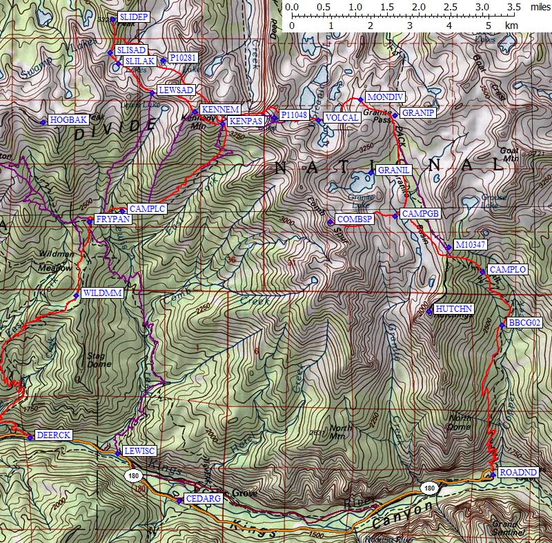
I reached the Tent Meadow bear box (waypoint BBCG02) at noon, without walking on snow at all. Weeks earlier the trail vanished under solid snowpack far below the box, where blown over trees still make the trail unwalkable and almost invisible. It was in the 70s and felt hotter so I took a nap before venturing onto the open brushy slopes of Upper Tent Meadow. Odd that the switchbacks were baking here, where we had previously gone straight uphill on snowshoes without seeing the head-high brush!
The last reliable water is where the trail brushes a stream at 9k, so I filled up all my bottles, soaked my feet, and smiled when afternoon puffy clouds blocked the sun. I was finally not hot! The snow became solid and I lost the trail as soon as I was in the tall trees. I found our previous campsite at 9.2k (waypoint CAMPLO), where the double-wide tent platform survived about 4' of snow melting. I found occasional sections of melted out trail, including at 9.8k where I had dinner around 4pm. (Hiking alone I often stop early and then hike until dark, something I never have convinced a group to do.) I spent an hour on dinner as the temperature dropped to 50, then packed on over the ridge at 10.4k.
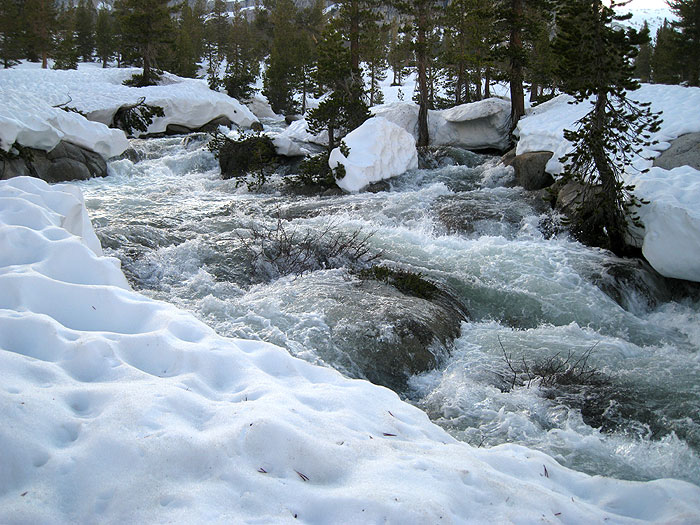
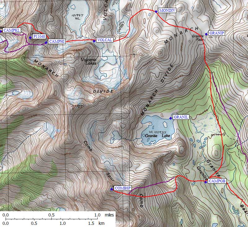
Weeks ago we sidehilled up the valley to avoid losing elevation, this time I dropped into the little bowl where the (snow covered) trail goes, then held about 10k elevation until I was high enough in Granite Basin to cross Granite Creek. This now-raging torrent had gnawed its way through almost all of the snow, leaving a few thin bridges. Where the water was exposed, it was clearly out of its banks. I crossed just above 10k and set up camp before 7pm (waypoint CAMPGB). Getting close enough to Granite Creek to pump water was dangerous, since the water was flowing just about everywhere and it wasn't clear where the snow was thin.
Granite Creek, out of its summer channel
After a dewey night where the snow didn't freeze but the drops on all my gear did, I left camp at 6am. I climbed the gentle slope south of the bump that forms Granite Lake, turning up onto that bump's ridge once above some cliffs. A bit of boulder hopping on this knife edge led to a broad saddle and the final 200' snow cap of Comb Spur (waypoint COMPSP). I found no register, but there might be one under all that snow! Coming down the east face of Comb was a long glissade in softening sun cups... my only good glissade of the trip.
I dried everything out in camp, packed up and left around 11am. My snow bridge was still holding, but had fresh cracks over most of its width. I tip-toed back to the east side of the valley, then turned north to Granite Pass (waypoint GRANIP) amidst knee-high suncups that were too soft to step on the tops. Snowshoes bridged the gaps but the tops broke randomly and it was tedious walking. Angling west over the Monarch Divide, I took the same ramp down to Volcanic Lakes that the group had used, with harder snow and more maddening sun cups.
Our old high camp, then and now
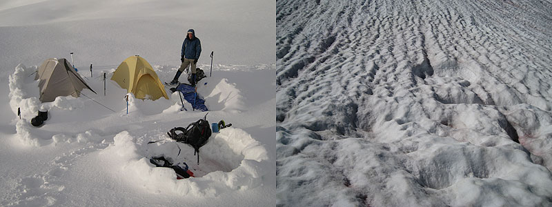
Last time we climbed toward the pass south of Point 11048 as the clouds and wind built up. This time it was warm and sunny so I went on over the pass at about 5pm. Surprisingly, I could still see our melted-out tent platforms and cooking trench (waypoint CAMPHI).
This pass looks OK on the map, but it's not a good route. There were melted-out slabby cliffs on the west side, and the snow above them was both steep and unpredictable. The Memorial Day blizzard snow was poorly adhered but fairly hard. When it cracked off I had to kick a new step in the snow below because my old step was moving as a plate. Not good when there was very little runout above the cliff. I dropped my pack and sidehilled hard 100m under cliffs to the right (north) to make good steps, then went back for my pack, faced the slope and kicked down to the easy slope east of East Kennedy Lake.
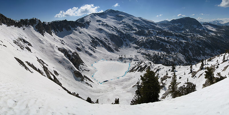
East Kennedy Lake and Mt Kennedy from pass near Point 11048
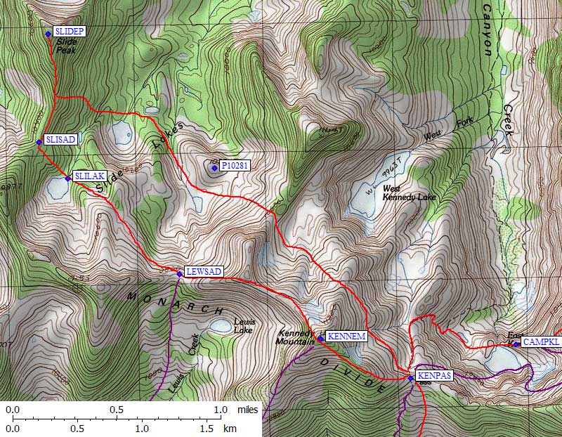
Here's the trick if you're going this way: Go NORTH of Point 11048! It's 100' higher than the pass I used, but it connects nicely to the ridge forming the north shore of Kennedy Lake. I camped on a snow platform above the outlet of Kennedy Lake (waypoint CAMPKL), arriving about 6pm, where the sun lingered late and the air was drier than in the drainage.
The next morning I took my full pack up to Kennedy Pass (waypoint KENPAS) after deciding NOT to go back the way I came. Too many suncups! I figured the south side of Kennedy Pass would be melted out and I could walk down a trail to Deer Cove, hitching a ride 11 miles to my car once I hit the pavement. The slopes around Kennedy Lake definitely needed crampons until 8 or 9am, the only time I needed them on this trip. I dropped to the tiny lake east of Kennedy Lake, then followed the (snow buried) trail route to the pass. The slopes south of Kennedy Lake (where I had intended to take the group) were not safely climbable with exposed slabs and softening snow with no runout.
Imagine my surprise to find a pair of large and small bear tracks going straight up the headwall (read "melted out cornice") at the pass! Later I saw the same tracks on Slide. Looks like the bears anticipated my route but went one day too early. I left my overnight gear at Kennedy Pass to do a dayhike a loop to Slide from here. My route was a level traverse across the east face of Kennedy (all snow), drop into the bowl southwest of West Kennedy Lake, over a ridge, down the drainage to Slide Lakes (south of waypoint P10281), and finally up the east face of Slide Peak. It worked great, but due to the western facing slopes the suncups were too hard to get a glissade going. I had to walk down all that snow which would have been soft and fun in the afternoon.
Slide was climbed in 1997, several times in 2004, then only me in 2010 and 2011. I got to the top (waypoint SLIDEP) at noon, took another nap, and made my way back to the Lewis Creek saddle (waypoint LEWSAD) at 230pm, entirely on snow. See my 2010 trip report for more details of Slide itself. By now my boots were soaked and drying my socks didn't help, because the snow seal has failed after 2 solid days in corn snow!
From the Lewis Creek saddle I followed the ridge to Kennedy. This is an interesting alternative to the southwest ridge that most people climb in spring, or the trail to Kennedy Pass and the east ridge which might be used in fall. The bump between this saddle and the summit goes as gendarmes and class 3 with a cliff on the north, or you can drop off the south side and traverse in talus. It is not a simple walk along the ridge as the map makes it seem.
I was the first one on Kennedy since July 2010, and that climber was the only one there in 2010! It doesn't get climbed that often either, probably just by list chasers. I strolled down the corniced southeast ridge, getting back to my Kennedy Pass cache at 5pm. It was warm in the sun but windy at the pass, so I rigged a tarp on some small trees as a windbreak and dried all my gear in the sun while cooking dinner. It was two warm sunny hours later when enjoying the view gave way to dropping to a good campsite.
I headed down the Cedar Grove (south) side of Kennedy Pass at 7pm not realizing how far it was to Frypan Meadow. I had no map of this side of the mountain, having expected to retrace my path over Granite Pass, but I had a few waypoints from last year's trip to Harrington and Slide. The old trail was melted out at the pass, but not for long! I plunge-stepped in hardening suncupped snow until I started seeing chunks of melted out trail around 9.5k.
Slowly falling trees on trail below Kennedy Pass
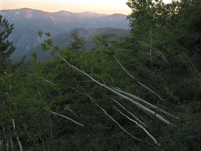
This very poorly maintained trail is probably hard to follow even in summer. This time of year, with snow patches and downed trees plus a layer of storm debris, it was a combination of luck and skill that just barely worked. Several times the trail vanished and I had to walk a spiral search path to pick it up again. Around 830pm I completely lost the trail at about 8.1k, near the first stream after a long dry section going around Kennedy's southwest ridge (waypoint CAMPLC, a fork of Lewis Creek). I camped here in lots of debris and tall trees, and in the morning picked up the trail on the far side of a patch of fallen trees, climbing sharply for a bit instead of dropping as one would expect. This was also where the first mosquitoes showed up.
Frypan Meadow (waypoint FRYPAN) has been devastated by downed trees. Two huge (3-4 ft diameter) trees fell at right angles to each other just below bear box, and one of them was tall enough to reach all the way across the meadow. Walk across that tree and make your way down the west edge of the meadow, because the trail on the east edge is now complete gone under a dozen or so downed big trees (all fell since last year). The trail to Grizzly Lake through Wildman Meadow is being maintained, but NOT the trail to Frypan or Kennedy Pass. See my 2010 trip report for more details on the vague trail to Frypan, which does not match the USGS maps.
I made my way down the increasingly buggy and hot and pollen-laden trail, reaching the pavement at 11am. After stashing my pack near the Deer Cove Creek trailhead (waypoint DEERCK), I walked less than a mile before getting a ride the remaining 8 miles to my car. Home for dinner, with a smile on my face.
Datum,North America 1983,GRS 80,0,-1.6E-7,0,0,0
Waypoint,D,BBCG02, 36.8297400475,-118.5801399946,08/05/2001,21:04:04,LOWER TENT MEADOW
Waypoint,D,CAMPGB, 36.8548500538,-118.6109199524,01/06/2007,17:33:04,GRANITE BASIN CAMPSITE
Waypoint,D,CAMPHI, 36.8768099546,-118.6422899961,01/06/2007,17:33:04,HIGH CAMP FROM MAY TRIP
Waypoint,D,CAMPKL, 36.8785799742,-118.6512800455,01/06/2007,17:33:04,KENNEDY LK CAMPSITE
Waypoint,D,CAMPLC, 36.8560500145,-118.6890599728,01/06/2007,17:33:04,LEWIS CK CAMPSITE
Waypoint,D,CAMPLO, 36.8419599533,-118.5858099461,01/06/2007,17:33:04,LOW CAMP FROM MAY
Waypoint,D,CEDARG, 36.7891700268,-118.6727999449,11/13/2001,04:30:51,CEDAR GROVE TURNOFF
Waypoint,D,COMBSP, 36.8537000418,-118.6293599606,07/26/2005,18:20:15,COMB SPUR 11618
Waypoint,D,DEERCK, 36.8038567305,-118.7154998779,11/13/2001,04:29:37,DEER COVE CREEK TRAIL
Waypoint,D,FRYPAN, 36.8535599709,-118.6985599995,06/14/2010,23:46:27,FRYPAN MDW BEAR BOX 7800
Waypoint,D,GRANIL, 36.8649200201,-118.6177899837,07/26/2005,18:22:14,GRANITE LK 10093
Waypoint,D,GRANIP, 36.8781299591,-118.6108299494,07/26/2005,18:02:09,GRANITE PASS 10673
Waypoint,D,HARRIM, 36.8700300455,-118.7335699797,09/02/2005,14:31:54,11_6 HARRINGTON MT 11009
Waypoint,D,HOGBAK, 36.8765200377,-118.7116899490,06/14/2010,21:59:32,HOBGACK PK 11080
Waypoint,D,HUTCHN, 36.8329399824,-118.6010799408,07/26/2005,17:53:19,MT HUTCHINGS 10785
Waypoint,D,KENNEL, 36.8784400225,-118.6528600454,05/23/2011,17:27:11,EAST KENNEDY LAKE 10200
Waypoint,D,KENNEM, 36.8789700270,-118.6682100296,09/02/2005,14:31:54,11_5 KENNEDY MTN 11433
Waypoint,D,KENNWL, 36.8919500113,-118.6604900360,05/23/2011,23:51:16,WEST KENNEDY LK 10000
Waypoint,D,KENPAS, 36.8762500286,-118.6604000330,06/14/2010,23:52:30,KENNEDY PASS
Waypoint,D,KENPS2, 36.8572238684,-118.6812137365,06/14/2010,23:53:03,RIDGE JCT TRAIL
Waypoint,D,KENPS3, 36.8657325506,-118.6671308279,06/14/2010,23:53:23,FOUND THE TRAIL HERE
Waypoint,D,LEWISC, 36.8001099825,-118.6904599667,11/13/2001,04:30:17,LEWIS CREEK TRAIL
Waypoint,D,LEWSAD, 36.8834463358,-118.6804199219,06/14/2010,23:51:59,LEWIS CK SADDLE
Waypoint,D,M10347, 36.8477699757,-118.5954600573,07/26/2005,18:01:17,RIDGE NEAR BM 10347
Waypoint,D,MONDIV, 36.8817299604,-118.6207000017,05/23/2011,17:25:56,MONARCH DIVIDE 10800
Waypoint,D,P10281, 36.8908699751,-118.6774200201,05/23/2011,23:50:49,POINT 10281
Waypoint,D,P11048, 36.8775999546,-118.6453900337,05/23/2011,17:27:38,POINT 11048
Waypoint,D,P11087, 36.8890700340,-118.6960200071,06/14/2010,23:51:02,POINT 11087
Waypoint,D,ROADND, 36.7952699661,-118.5828100443,11/13/2001,04:31:24,ROADS END PERMIT KIOSK
Waypoint,D,SLIDEP, 36.9001899958,-118.6918200254,06/14/2010,21:29:02,SLIDE PK 10915
Waypoint,D,SLILAK, 36.8901407719,-118.6901539564,06/14/2010,23:55:25,SLIDE LAKE
Waypoint,D,SLISAD, 36.8926577568,-118.6925954819,06/14/2010,23:51:29,SLIDE PK SOUTH SADDLE
Waypoint,D,VOLCAL, 36.8770699501,-118.6328699589,05/23/2011,17:26:11,VOLCANIC LAKES 10300
Waypoint,D,WILDMM, 36.8365913630,-118.7022094727,06/14/2010,23:45:38,WILDMAN MDW 7500