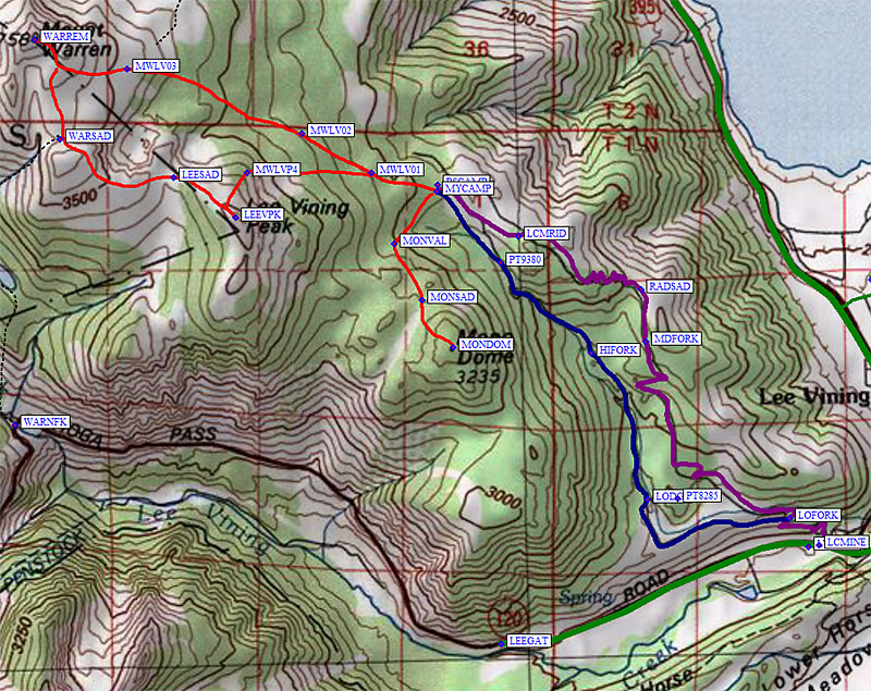
I followed a "Log Cabin Wilderness" sign (at waypoint LOFORK) to the right. Both forks had tracks on them and there was a gate with a Road Closed sign... but the gate was open. (I came out the other road, see details below.) Camp was at 8000' (NE from waypoint PT8285), only 800' above the car but with a far better view and no traffic noise. It was 10 degress overnight, not too bad for January!
I started up the road again at 630am, never saw the junction at 8800' (waypoint MIDFORK), and ended up at a saddle 9000' saddle by a radio tower (waypoint RADSAD). I put on snowshoes here as the snowmobile tracks died out.
I guess the snowmobiles were just riding up for a view of Mono Lake.
The road was obvious on the switchbacks, but once the ridge levelled out there were few clues and ever fewer reasons to follow the road. I switched to the west side of the ridge (waypoint LCMRID) for a better view but could no longer see either road that shows on the map.
I set up camp (waypoint MYCAMP) shortly after noon, at 9700' in the tall trees southwest of the Boy Scout Camp sign (waypoint BSCAMP). This turned out to be about the last good place to camp! Above this, especially to the north, the terrain was very windswept with stunted trees, but obviously the mine and the camp were set up here because it is sheltered.
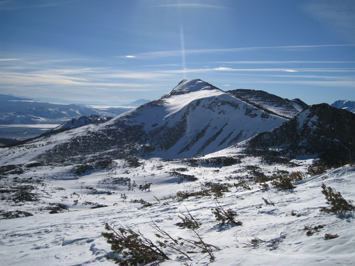
With time to spare I added Mono Dome to my itinerary, arriving on the summit (waypoint MONDOM) at 3pm to find a cairn but no summit register. There were some rocks to scramble over near summit, but mostly I climbed on snow. In the summer I think brush would be a problem. I enjoyed the view, then spent only 45 minutes returning to camp at 415pm. This being January, I finished dinner in the dark. Surprisingly it was a much warmer night, just below 20 deg even though I was 2000' higher than the night before.
I left camp at 7am as the sun rose, mistakenly leaving crampons and ice axe in camp due to the soft snow I had encountered so far. I topped out on Mt Warren (waypoint WARREM) 1140am. The last person on Warren was here in Oct 2010, most people climb May-Oct from the Camp 9 parking area as I did in 1997. The northern approach from Lundy Canyon was mostly blown dry and even my route was mostly bare rock above treeline! A high snow year, but low snow here.
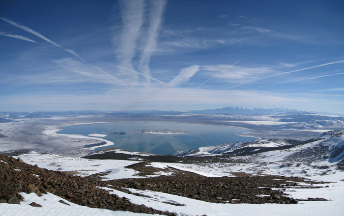
Above tree line on Mt Warren, looking at Mono behind Lee Vining
Warren was easy, just a slowly angled traverse on gentle terrain until the talus near the top. The traverse to Lee Vining was mostly easy, bypassing the bump near the south saddle of Warren (waypoint WARSAD) and skirting impressive cliffs to the west saddle of Lee Vining (waypoint LEESAD). Snowshoes with good metal cleats and ski poles were just fine on the final summit ridge, and I reached the top (waypoint LEEVPK) at 230pm.
My plan to drop directly to camp from Lee Vining wasn't safe without the gear I had left in camp. A variable wind slab too steep to go down with snowshoes and too icy to kick my heels into! Bummer. After starting down and chickening out, I had to climb back up to peak and drop off the northwest ridge to a north shoulder where the snow was not as steep and there was better runout. I returned to camp about a half hour earlier than the previous day.
Since I had a whole day just to walk out and drive home, I decided to walk out on the other road just for variety. I first got on something that looked like a road around 9200' (just south of PT9380). Above that I was just breaking crust in the trees. Going down I managed to find the junction where the two roads are connected on the map (waypoint HIFORK), but the connector is barely visible and clearly not a current road. I stayed on the wide road down past fresh bear scat at 9k and 8k as the surface changed from windpack to a packed snowmobile trail. This is the actual Log Cabin Mine Road (blue line), not the route I walked up (purple line).
There's a nice looking lodge (waypoint with named cabins (Astoria, etc) as the canyon opens up at 7900', but I have no idea if it's open to the public or how to contact them for reservations. (If you know, please contact me.) The hike out was much shorter and only took 2 hours. Soft is good going down! Since it was steeper and less packed by snowmobiles, this would have been a tedious way to hike in given the snow conditions.
Datum,North America 1983,GRS 80,0,-1.6E-7,0,0,0
RouteName,1 ,LOG CABIN MINE RD
RoutePoint,D,LEEVIN, 37.9503500462,-119.1129100323,05/12/2000,16:45:56,395 JCT 120 NEAR LEE VINING
RoutePoint,D,LCMINE, 37.9405100346,-119.1269500256,01/21/2011,20:07:17,LOG CABIN MINE RD JCT 120
RoutePoint,D,LVRANG, 37.9403799772,-119.1283299923,03/15/2011,18:28:02,LEE VINING RANGER STATION 7200
RoutePoint,D,LOFORK, 37.9431500435,-119.1305600405,01/21/2011,20:07:39,FORK IN RD TO CAMP
RoutePoint,D,PT8285, 37.9450999498,-119.1443599463,01/21/2011,20:07:55,
RoutePoint,D,MDFORK, 37.9603254795,-119.1483153105,01/21/2011,20:08:38,FORK IN RD TO CAMP
RoutePoint,D,RADSAD, 37.9654818773,-119.1488710642,05/16/2011,18:10:03,RADIO TOWER SADDLE 8900
RoutePoint,D,LCMRID, 37.9706627131,-119.1639072895,05/16/2011,18:14:13,LOG CABIN MINE RIDGE TOP
RoutePoint,D,MYCAMP, 37.9750100374,-119.1740299463,01/06/2007,17:33:04,TALL TREES AND NO WIND
RoutePoint,D,BSCAMP, 37.9756499529,-119.1738799810,01/21/2011,20:09:44,BOY SCOUTS CAMP SIGN
RoutePoint,D,PT9380, 37.9680500031,-119.1661299467,01/21/2011,20:09:12,FORK IN RD TO CAMP
RoutePoint,D,HIFORK, 37.9592700005,-119.1550199986,01/21/2011,20:08:27,FORK IN RD TO CAMP
RoutePoint,D,LODGE, 37.9450000525,-119.1481000185,05/16/2011,19:33:23,
RouteName,4 ,MONO DOME
RoutePoint,D,MYCAMP, 37.9750100374,-119.1740299463,01/06/2007,17:33:04,TALL TREES AND NO WIND
RoutePoint,D,MONVAL, 37.9698799849,-119.1791900396,05/16/2011,19:11:22,
RoutePoint,D,MONSAD, 37.9643900394,-119.1758400202,01/21/2011,20:14:34,VALLEY N OF MONO DOME
RoutePoint,D,MONDOM, 37.9598200321,-119.1719700098,01/21/2011,20:13:20,MONO DOME 10622
RouteName,5 ,WARREN AND LEE VINING
RoutePoint,D,MYCAMP, 37.9750100374,-119.1740299463,01/06/2007,17:33:04,TALL TREES AND NO WIND
RoutePoint,D,MWLV01, 37.9768300056,-119.1820800304,01/06/2007,17:33:04,TRAVERSE BELOW LEE VINING
RoutePoint,D,MWLV02, 37.9806699753,-119.1906299591,01/06/2007,17:33:04,
RoutePoint,D,MWLV03, 37.9869199991,-119.2121000290,01/06/2007,17:33:04,MT WARREN EAST RIDGE
RoutePoint,D,WARREM, 37.9897899628,-119.2234200239,09/02/2005,14:31:54,22_1 WARREN MT 12327
RoutePoint,D,WARSAD, 37.9800900221,-119.2203500271,01/21/2011,19:44:00,SADDLE S OF WARREN
RoutePoint,D,LEESAD, 37.9764056206,-119.2063915730,01/21/2011,20:11:21,SADDLE S OF LEE VINING PK
RoutePoint,D,LEEVPK, 37.9724500179,-119.1986999512,01/21/2011,20:10:29,LEE VINING PK 11690
RoutePoint,D,MWLVP4, 37.9768400192,-119.1973099709,01/06/2007,17:33:04,
RoutePoint,D,MYCAMP, 37.9750100374,-119.1740299463,01/06/2007,17:33:04,TALL TREES AND NO WIND