| Cast of Characters: | ||
| Ben Kurdt | - | lead guide; just married, bought a house, & going back to school! |
| Peter Anderson | - | assistant; guides as a "break" from being a flight nurse |
| Martin Lucero | - | assistant; premier mountain cook, selector of 4◊ cafes |
| Gordie | - | Princeton hombre (PH) #1* - blogger; force of nature |
| Evan | - | PH #2* - random dropper of hilarious 1-liners |
| Adair | - | PH #3* - neurosurgeon; best guy for me to walk behind |
| Kent | - | vet of Denali, Vinson, etc; excellent teacher of knots to 1 dyslexic |
| Rick | - | Movie Savant; devoted soccer coach; fellow Sierra-o-phile |
| Marty | - | immense strength of character; summitted with none of his own gear |
| Roland | - | awesome tent mate #1; sad to see him go from BC |
| Michael | - | awesome tent mate #2; fellow fan of Chelsea Handler |
| Yours truly | - | "little girl, are you lost?" |
| *Former boat mates from their Varsity Eights Rowing Team; average height - 6'4". They do not break trail well for short folk! | ||
A terrible plane sleeper, I had plenty of meditation time on the looming task during the long overnight flight to the Southern Hemisphere. A bit short on: paid vacation time, disposable income, and mountaineering know-how for such an endeavor, I had set Aconcagua as a seemingly unattainable goal after finishing WTC in 2007. At snow camp that year, I heard the story of a WTC leader who had climbed Aconcagua only a few years after completing WTC herself. Inspired by such a feat, and in need of a tangible goal to see me through my 19th mid-life crisis, I asked for the time off at work.
Having had an awesome time with Kurt Wedberg/Deb Leyh (Sierra Mountaineering International) climbing Orizaba/ Iztaccihuatl in November, 2008, SMI would be my logical choice. In 2009, my job as a public health physician was complicated by an influenza pandemic and massive downsizing of our health department; thus, I needed some flexibility in departure dates. International Mountain Guides (IMG), on whose permit Kurt successfully climbed Everest, and made famous by Discovery Channel programming, offered the choice of departures for 2009-2010 that SMI could not. At any rate, my boss requested that I wait until after New Year's to skip out. Thus, I would roll the dice with IMG, a decision which I would surely not regret.
With fresh memories of a last-minute pep talk from 4 buddies from my WTC-SGV Group 3 (Ted, Che, Steve, HG) at Lucky Baldwin's in Sierra Madre, I flew southwards through the night.
I arrived in Mendoza at about 10:30 am, after a brief refuel stop in Lima Peru, and a change of planes in Santiago, Chile. Flying to Mendoza from Santiago gives a sweet panorama of the Andes. Providing the sobering counterweight, was the pilot's announcement of "keep seatbelts tightly fastened" for the routinely encountered severe turbulence produced by the jagged backbone of South America.
No amount of bleary fatigue could quash my anxiety over a) whether my luggage successfully made the journey, and b) meeting the guides and the rest of the group. It turned out, however, that my fears were unfounded: upon seeing the friendly smiles and warm greetings from guides and other arriving clients (remarkably soon to truly be seen as "teammates"), negativity vanished. LAN Chile had indeed delivered all my bags. (Kudos must be given to LAN Chile for an all-around flight experience which crushes any U.S.-based carrier!) The same, sadly, could not be said for teammate Marty from Atlanta; American Airlines went 0/3 on his checked bags.
We checked into the Nuttibara Hotel in downtown Mendoza. Apparently, the lodging of choice for many climbing groups going to/from Aconcagua, I can give it a more favorable review than one Summit Post-er. Indeed the rooms are very (very) small, and not at all conducive to in-room gear sorting. Overall, however, the hotel has very large common storage rooms for group gear, a friendly bilingual staff, decently clean pool and functioning air conditioners (Summer time high temps in Mendoza were about 38-40degC / 101-104degF), free internet access, fair room prices, and a location close to excellent stores and cafes.
After group intros around the hotel pool, Ben and Peter conducted "gear audits" in our hotel rooms - reviewing the suitability of our major gear items. Meanwhile, Marty and Argentinean guide Martin dashed around Mendoza assembling reasonable gear replacements; all the while we all harbored hopes that the bags would make their way to the Nuttibara. Despite this major "exigency", Marty was going to gamely proceed, further bolstered by donations of spare stuff from the group.
In the morning, we picked up permits at the tourism office after working over a downtown ATM to pile up the $650+ for each of our permits. Our van trip "up the hill" would take us from brown skies to blue, a familiar journey for Californians. After a gourmand feast in Uspallata, we got to Penitentes, a small ski resort town. There, last-minute logistics were mapped out with IMG's local outfitter, Fernando Grajales (FG) Expeditions. With Martin as liaison, FG would handle the mules, the arrieros (muleteers), and the truly complex movements of the group's gear. We spent the delightfully cool and breezy afternoon in last minute gear (specifically tents) checks. The new Eureka 2-person tents would prove to be stout, and an easy set-up in adverse conditions.
After a "top-off" of calories and good coffee at the hotel (and a chance meet-up with Kurt!), it was time to take leave. In contrast to the ruta normal (via Confluencia to Plaza de las Mulas, 16 miles generally done over 2 days), we would take the alternate "False Polish Route". This route is longer in mileage, uses a different base camp (Plaza Argentina), and definitely more scenic. Already increasing in popularity, I suspect it will soon be the ruta normal.
Our approach took us along the Rio de las Vacas, with 1000' towering cliffs/foothills on both sides, abundant grass, wildflowers, and even low trees. The beautiful scenery served as a marvelous distraction from the warm daytime temps. The river itself had an initial appearance of the chocolate river of Willy Wonka fame, slowly, but never completely clearing of its heavy silt. We arrived at camp in mid-afternoon, enjoyed a leisurely camp set-up, and were then treated to a huge surprise by the arrieros! Our first camp was celebrated by a dinner of grilled squash, eggplant, potatoes (sweet and otherwise), and beef. Indeed, it became quite obvious that my suspension of vegetarianism for this trip would add to my enjoyment, and also solve many meal-planning dilemmas. We even had a bit of Malbec to accompany the festive meal.
Temperatures were relatively mild at the low altitude, requiring a full zip-down of my -20deg bag. The reputation of Aconcagua ("Acon-kaka") as a dirty mountain was not realized at Pampa de Lenas. There was a ranger station, a mule paddock, and even a flush toilet of sorts. Overall, I was quite impressed with the cleanliness of at least this trail and all of its campsites, with the notable exception of high camp (Camp Colera).
After repacking the mules with camp gear, we donned our day packs for the second day. On this day, the typical weather pattern emerged with clear mornings, and afternoons marked by skies of a variably ominous nature, visible at variable distances. Today, we got our first glimpse of "the Stone Sentinel", nearly 13,000' above us, complete with a shaggy cap cloud. The forecast for the high altitudes was for snow over the next 2 days. Thankfully, we are 10 days away!
Unfortunately, it was at this camp that the full extent of Roland's heel blisters would be evident. By the following morning, one would have to be drained of pus. I gave him a course of oral antibiotics from my stash, Peter carefully dressed them, and Roland would grit his way to BC for subsequent evacuation.
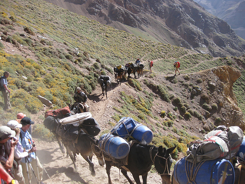
Before sunrise, we got to hitch a ride across the Rio de las Vacas on mule back (thanks guys!). We then ascended a narrow valley to BC, frequently overtaken by cantering mule trains. Their strength and agility were truly an inspiration to me, as over subsequent days, I found myself muttering, "be like a mule!" As the trains and their dust would pass, I'd cover my mouth and nose with a buff, to prevent excess inhalation of airborne crud. This seemed especially needed as it was at about 12,000' that began intermittent pressure breathing.
Make Way for the true heroes of the mountain!
Here I began in earnest my mantra for success: 1) eat as much as you can, 2) drink as much as you can, 3) walk slow, 4) take small steps, 5) breathe, and 6) don't worry so much!
Let the climbing begin!
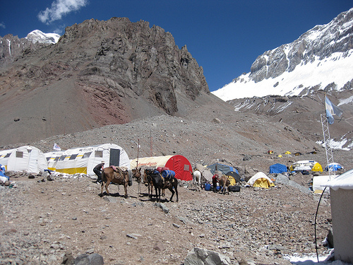
We arrived at BC with a building cloud bank, and then a wind-less snow/sleet fall. Suitable tent sites were situated far from our assigned port-a-potty (secured by burly guy lines, and labeled with a big "FG"). Nonetheless, we were far from the bulk of the noisy folks, and blessed with glorious views. Thankfully, nobody was ill from altitude, but we all wisely move "deliberately"
We all took full advantage of the creature comforts of BC, with permanent mess tents, satellite & internet access, coke, and beer. We did not, though, need any 'hamburguesas', as we were fed amazingly well by IMG, and FG. The culinary detail is one of the major benefits of guided expeditions. I for one am a lazy, unimaginative cook at sea level, something which won't improve with altitude.
Our water source is a blue barrel, receiving glacial run-off via a pipe. As a rule, we then treated our water, with Potable Aqua Iodine tablets allowed to 'percolate' in a large collapsible jug. Fully treated water then is transferred to the "clean" jug. Whenever able, I treat my own water using chlorine dioxide tablets. ClO2 is as effective as straight iodine, and it doesn't impart the brown tinge or as nasty a taste. It is, however, much less economical in size and price, making it perhaps impractical for large group use.
Base Camp: Plaza Argentina
We lingered at breakfast, serenaded by AC-DC blaring from a 'boom-box' in a nearby mess tent (a Southern hemisphere thing?). Our rest day was spent truly resting. We sat in the warm sun, waiting for our obligatory visit with the base camp doctor. We had a not quite perfunctory check of blood pressure, pulse, O2 saturation, and symptom query. By that time, Roland's heels had 24 hours of antibiotics, and 12 hours of backless shoes, so much improved that the doc insisted that they were not infected, and that people have summitted with worse. Yeah, right, we all knew better! With any further boot insult, poor Roland would be hobbling severely. We will greatly miss his incredibly sunny humor.
His card game was unimpaired, as he and I spent the afternoon playing cards. I was about 0 for 200+ hands!
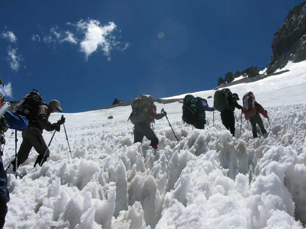
Probably the most difficult day, besides summit day, was the carry to CI. This segment of trail was easily the roughest, passing through snow fields, and heavy "scralus" (my personal term for: scree + talus = uncomfortable to haul 50+ lbs over/through). Thankfully, the difficult terrain was also very interesting. We got our first good looks at Penitentes (exaggerated sun cupping). From a distance, they glitter in the sunlight like a pile of diamonds. Up close, they are a bit of an obstacle course.
Wading through penitentes (I am 4th from the right)
The day started with beautiful sunshine above us; above the higher peaks, however, was a "swarm" of lenticular clouds. Thus, the weather would bear watching. We retraced our steps to CI, with loads not appreciably lighter than the day before. During the final steep segment, clouds began to build, and the wind blew cold, too cold for mere liner gloves. Not wanting to break rhythm, I waited a bit too long to retrieve my insulated gloves from my pack lid. After doing so and falling back with Ben as sweep, a snow squall descended. Knowing that our lead guide would not want to be trailing the group as the weather turned crappy, I increased my pace to rejoin the group. Crossing my fingers that a spurt of exertion at 16,000' wouldn't be too costly, we caught up as we hit the plateau on which CI was situated. We "expedited" camp set-up to accommodate the 30-40 MPH gusty winds, and vigorous snowfall!
Luckily, the snow abated around midnight but the wind kept screeching until about 0300-0400.
We awoke to a stunning "bluebird" day for a carry to CII. The terrain was much easier to negotiate, even with heavy packs. Zigzagging up a long gradual slope, we then crossed over the Ameghino Col (This is where the "Guanacos" variation diverges from the standard "False Polish Route"). We ate lunch in a large bowl, and then resumed a gradual uphill climb. After a traverse across an ill-placed snow field to CII, well worth the effort. It was an awesome camp, with dramatic views to the north across the Andes. After setting down our caches on our chosen sites, we scree skied back to CI in < 1/4 the time required for our ascent.
We learned at approximately this point of the climb that some guide services do not utilize carry days, with porters instead transporting loads (including waste) up the mountain. After a flowery show of embellished outrage (!), we quickly realized that ascending the mountain not quite 2 times not only adds 'cred' to the effort, the carry days are really very important for acclimatization.
We were all quite eager to depart for CII, although I kept wondering to myself if/when I was going to start to sag from altitude. Many of us took Diamox (acetazolamide) using various strategies. Most common was bedtime use of 125 mg to improve sleep (It decreases altitude-associated periodic breathing, thus reduces likelihood that tent mate will freak out while listening to you breathe). Some were using it continuously (2-3 times daily); I was only taking it in the mornings on "move" days, in addition to bedtime use above BC.
Upon our move to CII, we were again granted the privilege of placid weather. We had a marvelous view of the Polish Glacier itself and the summit, and were able to follow the progress of a pair tackling that technical route. During afternoons/evenings, we were serenaded by a trickling glacial stream until it refroze.
On the evening after our move to CII, the guides polled each of us privately. They wanted to get an up-to-date, candid assessment of each of our individual health. Some of us were pretty tired, some a bit hampered by lingering turista. I reported that my appetite, sleep, and strength were fine. Ben checked our O2 saturations; mine was 72%. We were not to know these values, but I was able to sneak a look and, as a physician, not necessarily become unhinged at the sight of what would be pre-terminal value at sea level. Ben seemed to show some mild consternation in his expression, even as I reported that my appetite, sleep, and strength were very satisfactory. Indeed, I was tired, and had an incredibly stuffy nose, but no headache, cough, or other possible miseries. I was up for further ascent, but would certainly accede to any decision made. As it turned out, some normally chipper group members were a little droopy too. Gordie for one ate little at supper, and was without his usual mirth. A decision would be deferred until the morning.
We elected to carry gear up to CIII on the following morning, the first of a series of brilliant decisions made by Ben ("The Oracle"!). Out of CII, the trail ascends quite steeply. Those still in camp had a great view of the laborious start. Many of us (me at least!) were giggling at the notion of groups getting an impressive, rapid start, only to hide behind a rock outcropping while sucking the meager air. We continued to follow the trail on a more gradual upward slope. It seemed to stretch before us as a long ribbon of light grey on a huge darker grey slope. Along the way, we passed 3 older men. An exchange I had with one translated into English as: Me: "Good morning." Caballero: "You all are looking very well." Me: "Indeed, the key is walking and breathing - no thinking." Caballero: "Good - thinking is the work of the devil!"
HC emphatically announced itself far ahead of its actual appearance. A snoot full of urine stench greeted us as we reached the white rocks that give the camp one of its names. This, along with the more prevalent (mostly micro-) trash, was really the only hygienic bummer I encountered. Notably, Martin explained the origin of the other name for HC. Indeed, the name was derived, not from an epidemic of explosive diarrhea (cholera), but from a fight between 2 early climbers (colera = anger in Spanish)
We dropped our loads and crammed down lunch. A large cumulonimbus cloud was mushrooming in one of the neighboring valleys, compressing our plans. We rapidly descended back down to CII, as the thunderheads changed direction and pelted another camp . . . today.
We would rest tomorrow. Yahoo.
We took a well-deserved rest day at CII. We spent the day napping, eating and drinking, and admiring the views. Substantial lounging around camp and telling of stories was also undertaken. It is here at high altitudes that the truly talented raconteurs show their stuff.
We took 4.5 hours to get up to HC. As we contemplated setting out, the appearance of the sun over the mountaintops cheers us all. It is always a mood- and temperature-lifting event, especially as altitude increases radiative heat loss from the cold ground.
"San" Martin (el conejo = jack rabbit) ran ahead to "reserve" prime real estate for tent sites.
After a rapid tent set-up, we experienced an entertaining thunder snowstorm (affording us a fresh 3-4"). After about 90 minutes of fireworks and sound effects, the sun made its return, illuminating views of cloud layers both above and below us. Many of us were setting a personal altitude record at HC.
Our lead guide Ben poked his head out of the tent at 0300 to note a manageable wind and many visible stars. Thus, we were penciled in for our summit push.
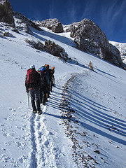
The day would serve up a hodgepodge of weather conditions. In an "Argentinean alpine start", we left HC in crampons at about 0700 (any earlier is considered unnecessary - and excessively cold!). Snow conditions were quite good. Up to Plaza Independencia (reputed to be the highest human-made structure in the world), conditions were cold, still only a modest wind, but clouds were gathering (not any earlier, however, than prior days). Traversing "Windy Ridge", we continued to dodge the truly nasty weather for which Aconcagua is noted. Trading trekking poles for axes, we pushed on to the base of the Canaleta. This steeper, winding segment meanders up to the broad summit of the highest point in the Western hemisphere.
Traversing Windy Ridge
By virtue of our efficient ascent to date, we all thrashed up the Canaleta; I personally required 3 pressure breaths for every 1 step for the final 500'. My strategy here: pretend I am glued to the teammates before me. We kept looking up, dismayed to keep seeing yet another rocky outcropping above. Finally, we rounded one last outcropping, clanged points on some bare rocks, and there we were! In all, the ascent took 8.5 hours.
Summit shot - Team Aconcagua
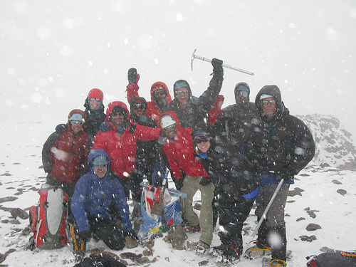
We had been so absorbed in our efforts that the deteriorating weather caught some by surprise. I, however, have a pretty heightened awareness of thunderstorms, based on years living in Florida and a childhood recollection of a very close-by lightning strike. (It wouldn't be deemed a phobia at altitude?!) We were busily shooting summit photos as snowfall intensified, and thunder and lightning booming below (?!) us. Thus, celebrations were going to have to be deferred until HC. We scampered down to HC in about 3 hours while about 12" of snow obliterated our tracks. If you are not going to carry wands, have crazy good guides! Back at our tents, we collapsed in a happy joy!
We started the downhill trek in fresh snow, but were able to remove crampons and scree ski to Plaza de las Mulas. This time allowed me the chance to review the excursion. Certainly, props go to our guides, Ben, Peter, and Martin. Their knowledge and forbearance were critical in the effective management of a large group. The decision to make the carry to CIII first, deferring a rest day by 24 hours was crucial in putting the group in a position to sneak through the narrow weather window. Groups not using that 'crack' in the weather were forced to either abandon their summit bid or wait another 24-48 hours in a snow storm. Waiting at CIII (HC) can be as debilitating as the rigors of climbing.
The wildcard in any expedition, however, are the clients. Never mind that all of us ascending above BC were able to summit; the unity, sense of "team" was outstanding! Each guy uniquely contributed to the stew of the group success, heavy on the humor. We stuck together in a solid line. I am so grateful to have hiked with them, and there was no way that I was not going to stand with that group on the summit!
After moving table and chairs, we slept deeply on the wooden floor of 2 mess tents. The following morning, we were treated to a real breakfast of pancakes and Dulce con Leche (nectar of the gods!). We made our hike to the TH, galloping out in about 61/2 hours, besting our mules, and the van pick-up. The desolate, featureless terrain which characterizes the Valle de los Horcones was as uninspiring as was advertised. We pitied the poor folks slogging uphill in the oppressive heat and sun! We did stop at the Camp at Confluencia for about 15 minutes, time enough to slug down some chilled juice and admire the relatively clean and well-rested faces in the mess tents.
OK - Now what? . . .
Why we climb
Reading List (mine):
1) "The Age of American Unreason" - by Susan Jacoby
2) "Are You There God? It's Me Vodka" - by Chelsea Handler (Above BC, it encouraged deep breathing via hysterical out loud laughter)
3) "Legacy of Ashes" - by Tim Weiner
4) "Pocket Sudoku" - by Will Shortz - Barely touched - too irritating!
Duffle Bags - must be of bomb-proof constitution for mule transport. Garbage bags are also useful, to avert any chance of dust or rain getting onto critical pieces. It was hilarious, but my rolls of toilet paper got shredded!
Ice Ax - If not for actual self-arrest, an axe is helpful for household tasks like chopping ice for water.
Trekking Poles - I love my poles, and wouldn't leave home without them.
Crampons - needed on summit day, depending on the exact conditions. They are tough to predict with any certainty; thus, they will need to be dragged up the hill on carry days. Some recommend aluminum points for their portability. Reality is, however, that most aluminum types would have been completely trashed by the time we descended back to BC.
Footwear - I wore Keen Targhees (light hikers) between TH and BC. Above BC, we all wore double mountaineering boots (me-Vasque Radiators). Sandals were used for 1 stream crossing (mules for the other!). Some guys had "Feathered Friends" down booties for camp wear and swore by them.
Down Jacket - I used a "Rab Neutrino" around camp from 16,300' up. Very light, packable, warm, and makes a great pillow too.
Sleeping Bag - I used a Marmot Col (-20deg); not a particularly cold sleeper, I was very warm. A 3/4 Therm-a-Rest and a blue foam pad was a good combo of portability and comfort.
Mitts/Gloves/Liners - make sure that whatever system you use, that they are easily accessible in your pack.
Chemical Warmers - I used them for my hands on summit morning - extremely helpful IMHO.
Gaiters - not absolutely necessary; I trashed my super gaiter fit by doctoring my double boots, sent them down the mountain in my duffel, and never missed them.
Bandana/Hat/Buff - I wore the buff fashioned as a sort of hijab to protect myself from the sun. On the hike out through the Horcones Valley, alas, I did not. My face got so burned (even with use of spf 55) that I probably frightened half the population of Mendoza.
Sun Glasses/Glacier Glasses - bring both; I decided to bring only glacier glasses, but put the wrong hard silver case into my duffel. Luckily, a little duct tape was able to serve as side shields.
Nalgene Water Bottle Cozies - help retard water bottle freeze. I only needed 1.
Snack Food - this summit was brought to you by Peanut M & M's, Jolly Ranchers, Runts, and "Whole Foods" organic hemp granola/magic muesli/cranberry trail mix! I am not a huge fan of "bars" (Clif Bars make me puke at > 10,000')
Water Filters - forget them
Hefty & Ziplock bags - of varying sizes, were all-purpose disposal devices
Toilet Paper - I used < 2 rolls
Headlamp - I only used mine on summit morning.
Altimeter watch - for marking altitude, and also as a weather gauge (quasi-barometer)
Solar charger/rented satellite phone - Gordie blogged nearly every day using this gear.
Goggles - These were critical on our summit descent in wind and moderately heavy snow. Two guys without functional goggles were short-roped.
Medical Kit - specifics on its contents available upon request, just like references!