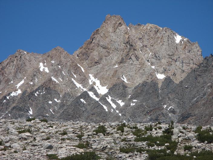
We left our car at the North Lake parking area around 9:00 am Saturday morning and headed up the Piute Pass trail. By design, and if things went right, nine days later we'd come off Lamark Col and be back where we started. The rangers said it would be a bug fest, but we were pleasantly surprised, the mosquitoes didn't seem horrible compared with other trips. The hike up to Piute Pass is a great way to start a trip with heavy packs. There is only modest elevation gain and is a classic mix of slabs, glacially formed lakes and green meadows. The final bit up to the pass was snow covered but well trodden. From the pass we got our first view of Mt. Humphreys. Every time I see a tough objective in the mountains, I can't help thinking that it looks unclimbable. I have to tell myself, don't worry, there's a route there.
Anyway, from the pass we picked our way over snow, occasionally following a pretty good use trail over to Muriel Lake. We established our first camp at 11,300 feet a little after 1:00 pm. We spent the rest of the afternoon honing some rock skills and getting ready for our Sunday attempt on Humphreys. For the first of several evenings our camp was basked in bright moonlight. We set an alarm for 4:45 am and hit the sack early. Craig and I slept under the stars while the rest retired to their tents.
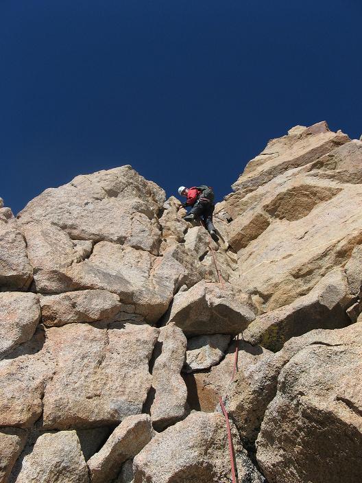
Roused to a purple sky on its way to blue, we pulled ourselves out of warm synthetic cocoons and into Sunday's pre-dawn cold. Brandon woke with a migraine and was unsure whether or not he would be able to climb. He got some hot liquid and medicine in him and by 7:00 am felt he could start off on the approach hike and see how he felt. We headed out, moving by line of sight toward the classic south west side route of Mt. Humphreys. The approach has its ups and downs with plenty of water along the way. The closer we got to the base of the mountain, the more climbable it looked. Secor says to climb scree to a left leading ledge. We found his notes right on target. On the far right side of the southwest face is a huge talus, scree fan. There are several chutes; however one is marked with some rust colored rock with large rust colored outcroppings in the scree below. The left leading ledge is directly above this and is marked with an awkward chock stone at its start. In the photo below the chock stone is in the dead center of the picture.
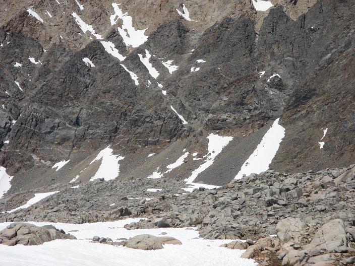
The chock stones are easy to pass and then the ledge climbs diagonally left and passes over a few chutes. The route is easy to follow. The highest chute was filled with snow and it made for a great two-hundred foot snow climb for Julian, Craig and I. Easy class three rock on the side of the chute worked for Nathan and Brandon. Shortly above this last chute, we arrived at the notch where the harder climbing starts. Craig opted to wait at the notch as the four of us pressed on.
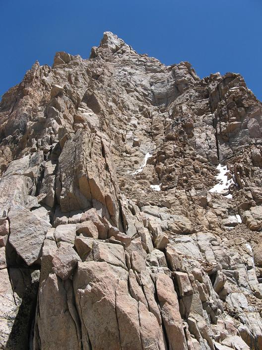
The route from this point is obvious. It's straight forward class three up into a steep bowl. When the climbing gets harder, one forth class pitch leads up to the right, ending at a belay ledge on an exposed corner.
The next pitch is also forth class and perhaps seventy feet up an open book crack, then right around a corner. The bit before the corner is vertical, but has super clean holds and feels real safe.
Around the corner the climbing is a bit easier. Above this pitch you're standing on the crest of an airy ridge that curves up and left to the summit. The ridge is an amazing five minutes of easy class three; however, the height and exposure make you feel like it's a space walk.
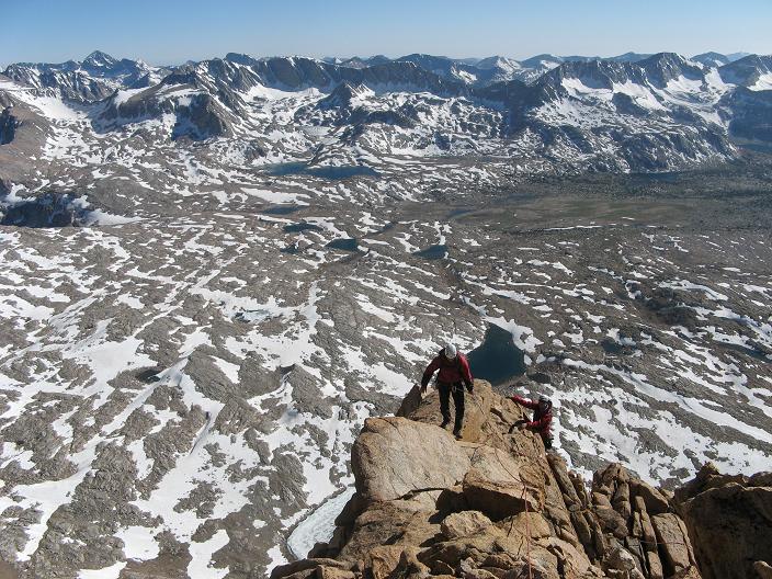
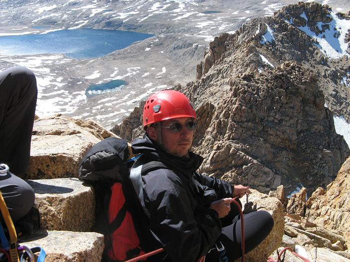
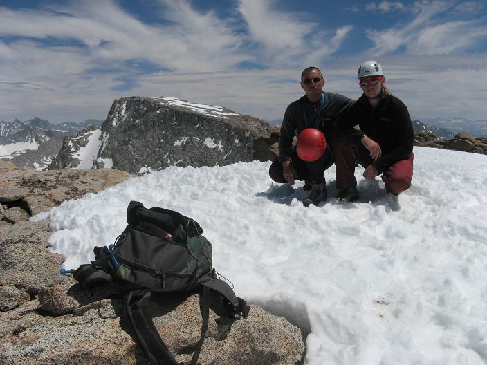
I've never seen a clearer day in the Sierra. We could see as far south as Mt. Whitney and beyond. By the time we were all on the summit, we realized the climb took much longer than expected and we felt a sense of pressure to get down after arriving at 5:15 pm. By the time we left the summit we knew we had bought ourselves a night hike. Balancing speed with safety was the pressure as we moved off the hard stuff. We opted for a series of three rappels and these took a long time with a group of four. The descent to the notch was further complicated by a cold, violent wind funneling up the route. The wind gave us some rope management problems, but despite them, we all were safely back at the notch around 07:15 pm. We had left bright pink survey tape markers strung to little cairns at key points along the ascent. This helped with route finding on our way back down the ledges to the original scree field. As we20made our way off the loose slopes toward the mountain's base, the moon rose and provided a white glow for our zombie like walk back to camp. Headlights guided our feet and the moon guided our direction. The later it got, the less sure we were of our location. Before the sun went down, I had made a point of marking the features of the horizon to our south. Despite the near total darkness, the silhouettes of the subtle peaks around Muriel Lake now became our guiding stars, our touch stones for finding our way home. I kept telling myself and the others that as long as we kept moving toward those features we'd be fine. After three hours of hiking through the darkness, we came to the hillside that I thought marked our campsite. I was wrong, and the realization crushed me mentally. We were all drained by the exertion, and now to be unsure of our location just made matters worse. Craig suggested we hook to the left and after just a few minutes we started to notice familiar signs from the terrain. A short while later we spotted our tent and were back in camp, elated that the day was over. It was 11:05 pm. Me and my two boys shared a cramped tent, and Nathan and Brandon quickly retired to their own. We had no energy to cook. We were all completely spent. From the warmth of our sleeping bags we ate chocolate, sipped water and drifted into a sleep that would only be disturbed by the next morning's rising sun and whatever a new day would bring.
Our original plan was to move south over Alpine Col on Monday. Given our late return from Humphreys the day before and another developing factor, we decided to take a rest day. Soon after we were up and around Brandon expressed concern over continuing the trip. This was his first multi-day trip into the Sierras and was struggling with some personal issues. He decided to think it over during the day. We passed the time resting, reading and generally hanging out. Around noon I went out for a casual hike. I wanted to get a feel for the glacial history carved into the slabs surrounding Humphreys Basin. I climbed to a round peak just north of Piute Pass and was amazed to see glacial polishing and directional scaring, which indicated glacial movement flowing toward Piute Pass. This evidence at the height of 12,000 feet, indicates that the entire basin was likely filled with ice to a depth of 700-800 feet. Sitting in the sun trying to imagine this vast expanse of ice was an amazing experience. It's truly humbling to contemplate the forces that formed and continue to shape this immense mountain wilderness. I could only wonder, if these massive ancient glaciers were here before and are now gone, what led to their disappearance? Will they return? With these thoughts in mind, I returned to camp arriving around 3:00 pm. On arrival I discovered that Brandon had decided to go home and was making plans to leave Tuesday morning.
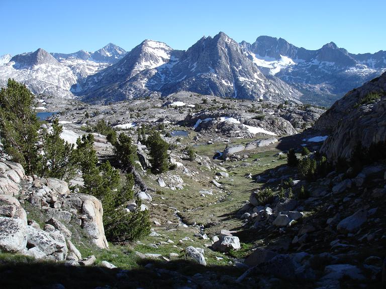
The sun rose again Tuesday in a perfectly clear sky. We sorted and packed gear and reviewed the maps again to be sure of our route over Alpine Col. At the same time, we worked out how to split up the community gear Brandon would leave behind. He was set to go around 9:00 am. We said our goodbyes and then we were ready to move a little later. We've never had a team member break from the group before so the remaining four of us were in a bit of a quiet funk for the day. This feeling was probably enhanced by the remoteness and difficulty of Alpine Col. We first skirted around the northern end of Muriel Lake and then started hiking south into Goethe basin. This part was easy as we passed the first un-named lake on the west. We crossed over at this point to the east side of the basin climbing intermittent snow and massive talus. The moving was demanding, tedious, slow and tiring. We reached the high point of the pass about four hours out of our camp at Muriel Lake. After resting and eating we started the descent down toward Darwin Bench. Although the talus was smaller, the route is still not easy. There is no use trail, some of the terrain is steep and there's a bit of route finding. We stayed on the east shore of the first lake then crossed the steam to the western side further down. Finally we stayed on the western shore of the last lake. At the southern end of this last lake are two obvious low points or notches. Both are entrance points to gullies heading down to Darwin Bench. The gully to the east contains the stream issuing forth from the lake. The low point to the right or west, leads t o a beautiful grass and scrub filled chute that drops directly down to the lush meadows and rocky outcroppings of Darwin Bench. Seeing this jewel of a landscape worked wonders on our mood.
We located a wonderful campsite on the eastern side of the bench and settled in. This campsite has a great spot for two people to nestle bivy sacks into a tight little spot between some scrub pines. Craig and I picked this place as home for the next two nights. Julian and Nathan pitched their own tents and all of us were able to shake off the funk and comfortably settle into our backcountry life. It had been the second of two exhausting days out of three, but spirits were high and we were glad to be back on familiar terrain and in such a lovely spot.
Wednesday morning, Nathan and I wanted to climb Mt. Huxley. It was a long approach, but worth the effort. We left our camp on Darwin Bench taking only small day packs. We moved cross country to the south finally joining up with the JMT below Evolution Lake. Two hours out of camp we came to the west shoulder above Sapphire Lake.
We found a good stream crossing and proceeded up the shoulder toward the prominent chutes described by Secor. The climbing was easy and enjoyable with little loose rock. At the top of the far left branch there is a challenging third class section that leads to the summit ridge. The ridge itself is class two, but takes on a rather airy feeling near the top. Huxley is a seldom climbed peak and was well worth the effort. We were the first to climb it since August of last year. The climb down was kind of challenging because we climbed directly down the chute below the summit. In retrospect this would be a pretty fun class 2-3 ascent route. It's primarily a bare bottom chute with lots of cross ledges. By 5:00 pm we were back on the JMT hustling our way back down to Darwin Bench. Once again, the weather was great. There were just a few clouds and temperatures seemed to be warming up a little.
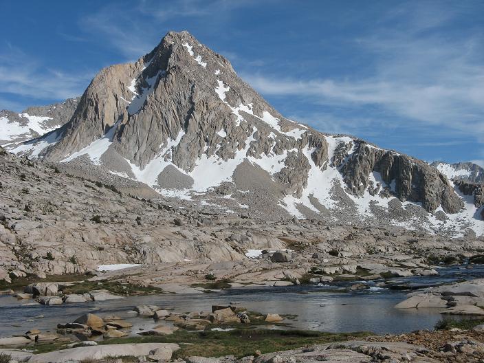
Thursday was an easy moving day. We wanted to get staged for our climbs on Mendel and Darwin. We lazed around in the morning and finally got moving around noon. We followed the faint use trail up into Darwin canyon and made camp at the bottom of a small cliff-like outcropping just opposite the Mendel Glacier's giant moraine. The spot was an absolute solar oven. We surrendered to our own self-fashioned shade shelters, read, dozed and watched the sun go down. We made firm plans for Friday, deciding to focus first on Mendel and leave Darwin for Saturday.
Friday morning my head was in a bad place. I pulled myself out of my sleeping bag at 5:45 am. It was freezing cold, I was tired of chipping my breakfast into bite sized chunks with my ice axe and I was apprehensive about the climb. We were going to try the east face route, which I had failed to summit in July of 2006. Nathan, Julian and I headed out before 7:00 am and made good time up to the basin below Mendel's east face. The sun warmed the snow, and softened my mood. The wind was calm and my mental malaise flipped into a great sense of joy. I was thrilled to be in such a remote place, climbing on a mountain that I had coveted for more than fifteen years. We move diagonally up snow and rock toward the first slanting ledge that leads up to the right. The ledge was still snow filled but we avoided it by climbing class two rock to the right of the gully. After a few hundred feet, the gully narrowed to perhaps ten feet and we could see a narrow ledge leading off to the left. We crossed left over the steep snow and after only perhaps one-hundred feet we came to another chute leading up and right again. This chute took us up another few hundred feet where we again crossed to another ledge leading left. This ledge is the final ledge that takes you into the sandy bowl below the imposing reddish rock of the summits east face. The climbing from this point is an easy mix of class two talus and scree with the occasional third class move thrown in for good measure. The higher we climbed into this bowl, the less we liked the look of what must have been Secor's chimney on the far left side of the summit face. We started eyeing the right side and north-east ridge. We finally settled on a chimney just to the right of the blank east face summit wall. We climbed it in two pitches. The first was about sixty feet of hard class three. Above that was a section that started with solid class four, but which finished with fifteen feet of 5.fun as some would call it. Julian led this second pitch and was Mr. Cool handling the difficulties. Nathan and I followed and were soon on top!
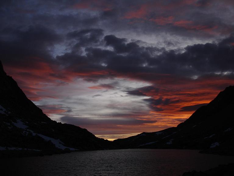
What a joy to share this fantastic climb and wonderful summit with my brother and my son! We enjoyed the summit for about fifteen minutes then started planning our retreat. Things didn't go perfect. We set up a solid rappel anchor to use with my two, eighty-foot, eight millimeter ropes tied in the middle. By directing the rappel to the right side of our climbing route, we were able to pass the final section of the climb with one, eighty foot rappel. This got us back to a good third class ledge. The problem came when we tried to retrieve the rope. The knot got wedged almost as soon as we started trying to pull it down. We tried repeatedly from different angles but it would not budge. There was no way we were going to get creative to try to save the rope. The end result is that until either the wind and elements destroy it, or a summit party removes it, Mt. Mendel will be displaying our leftovers of a great day in the mountains! My apologies to all for the aesthetic smear. The remainder of our descent went smoothly and with some fun glissading. We arrived back in camp before 5:00 pm. That night we were treated to an awesome Sierra sunset and got some great photos.
Friday's events on Mendel settled Saturday's schedule. With the rope whipping in the wind on one mountain we scrubbed the plan to climb Darwin. Instead we slept late and made a plan to cross Lamark Col on Saturday, which we did. Once we reached the pass, Julian made the side trip up Lamark in less than an hour. We moved downhill at a casual pace and made a final camp at a point just after the use trail joins the Lamark Lakes trail. Sunday the group was up early and back in the parking lot before 8:00 am.
This year's trip was one of the hardest we've had. We had tough objectives and some pretty hard climbing. The weather was spectacular and the scenery was all we could hope for. Special thanks to Brandon for keeping things on an even keel on Humphreys! As for the rest of the crew, thanks again for making this a safe and memorable trip into one of the greatest mountain ranges on earth!