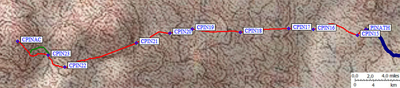
The hardest part of this climb was trying to figure out the DPS Guide, which has maps not to scale and climbing directions more complicated than necessary. See the trailhead page for maps and directions and waypoints. The border crossing was easy mid-week, but it might get pretty crowded on holidays. Lots of people from Arizona come this way to get to the beaches, but we were there for the rocks.
At visitor center they said to follow the white posts spaced every 50 meters beyond the parking area... WRONG! They lead north and you want to go west to the peak. Walk up the very short and very steep 4WD hill from the parking lot (waypoint PINATH), then keep going straight! Don't turn right when the road does (waypoint CPIN15), instead head across the lava flow to the dirt-covered ribs on the far side (waypoint CPIN17). The peak (waypoint CPINAC) is directly behind the biggest thing you can see (Carnegie). You can probably skip all the details below if you just remember you're always going west.
Climbing map: see also the
trailhead page
for driving maps
We started following the road, but John got impatient walking the wrong direction and struck off on his own for Carnegie (the peak in front of Pinacate). Daryn and I eventually gave up on the road, thinking that even if it did end up at the right place it was taking such a detour that it wasn't worth following. We went where we thought John had gone. He, meanwhile, had decided to cut across to where he thought we were going. This is why it makes sense to stay together! Our paths crossed, and he ended up north of us. Sigh. We wavered and waffled our way up the lava flows, which are sharp and loose and treacherous but also interesting to look at. Think splashed lava talus and don't trip. We didn't go down this way. The track log and waypoints on the map above are from our return.
Starting back near the cars, where you don't turn north on the road at waypoint CPIN15, you'll need to drift north just a bit while walking between ribs of lava to waypoint CPIN16. Work your way west across the lava flow to the closest dirt rib on the other side (waypoint CPIN17). Trust me, the walking is a LOT faster if you're on soil that will support plants. You'll be done with the sharp lava by about 0.7 miles from the parking lot. Several volcanic cones in the area look like the red cone (Cono Rojo) you parked next to, but you can't see the parking lot's cone from the peak so look over your shoulder every so often to make sure you're going to head back to the right place.
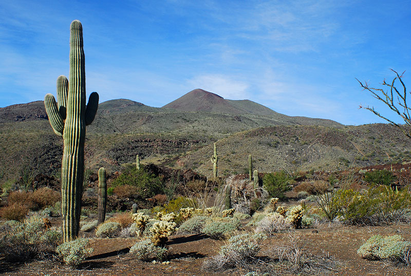
The peak in front of the peak (Carnegie and the general approach terrain): photo by Daryn Dodge
We found an intermittent use trail around waypoint CPIN18, but it's not much easier than just walking cross-country. The terrain flattens above that, and you lose sight of the parking area. Look for the gully at waypoint CPIN19 and stay left of the lava flow that comes out of it. You won't be crossing any more sharp lava flows! At waypoint CPIN20 there's a truly giant Ocatillo that sort of marks the entrance to a higher chute. Below here it's much broader, above here you can see the Red Cone.
By waypoint CPIN21 you're on a big use trail that hugs the base of Carnegie's cinder cone. The footing is crushed pumice, much better going down than up. DO NOT believe the peak you see in front of you is Pinacate. John struck off toward it, not wanting to deal with the crushed pumice and Jumping Cholla balls that roll down it, but my GPS stubbornly pointed to the right. You can follow the use trail between Carnegie and the black outcropping on Carnegie's shoulder, but it climbs higher than you need to... and immediately drops to the Carnegie/Pinacate saddle on the other side. We chose to go LEFT of that black bump, crossing the shoulder around waypoint CPIN22 and dropping into the shallow valley on the other side (waypoint CPIN23). You can sidehill to avoid elevation loss, but it's really soft soil and those damn cholla balls are everywhere.
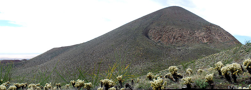
Cerro Pinacate proper, from the last shoulder: photo by Daryn Dodge
The final slope to the peak has an angle of repose (pumice and sand) that measures 30 degrees. Try to stay in boulders and rocks as long as you can (green line on the map at the top) on your way up, try to stay in the softest sand on the way down. We spent about 3 hrs getting to the summit, but would have done it faster on the route I just described. The temperature was 72 degrees and the 20 mph wind felt nice and cool after the heat on Kino! This area apparently gets insanely hot in the summer, but we hit a good day with partial clouds and that steady breeze. Otherwise, late Feb might be too hot already. Most summit register entries were in Spanish, as you'd expect. Lots of groups climb this peak but we didn't recognize any DPS people.