We finally started off on our dayhike, late at 8.45am. Saturday's goal was Dennison Mountain, a high point on Dennison Ridge separating the South Fork Kaweah drainage from the North Fork Tule drainage. Dennison Mountain is prominent from and lies roughly between Homers Nose and Moses Mountain. We planned to hike through forest to the ridge at a point east of the peak then run' the ridge west to the peak, for a total of not more than 6-8 miles round trip and 3700' gain. We began by heading north about a mile through forest and brush, crossing a couple of very brushy ravines before reaching Dillon Creek at about the 5700' level. We hiked up along the stream to a point where it splits at about 5900' then ascended into the forest in a northwesterly direction. The going was steep but open. After a few hundred feet of gain we began to find Sequoia trees here and there. There is something special about coming upon a giant sequoia in a forest, as opposed to along or near a roadway. We contoured north and came to a dry rocky gully which presented easy climbing west up toward a prominent subsidiary ridge running SSE from Point 8447'. This got us to within a couple of hundred feet of that ridge, which we attained at the 7400' level at around 12noon, stopping for lunch. Through the trees we could see the Central Valley 7000 feet below. It was a warm and sunny day but time was passing. After lunch we spent the next hour running' the ridge, which was mostly open, narrow, high, rocky and brushy: interesting, pleasant views, but slow. We then began contouring on the west side of the ridge, eventually reaching approximately 7800' level at 1.30pm.
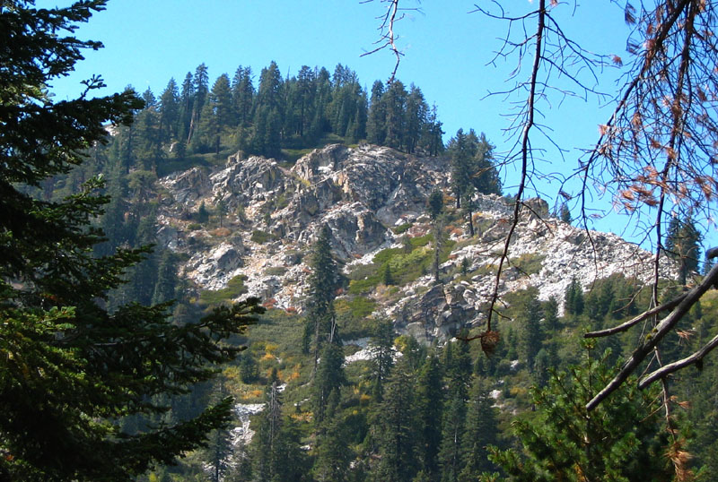
Dennison from 8k turnaround - picture by Steve Eckert
We could see Dennison Peak less than a mile away across the head of Jenny Creek Canyon. However given the remaining daylight, we estimated that although we could make the peak, we would not get back to camp until hours after dark. After finally concluding given the difficulty of the terrain that this was not advisable, we turned around. We climbed back onto the lesser ridge at 7900', and after a refreshing break headed back down the mountain. This time we descended directly southeast through steep open forest slopes, heading off the lesser ridge from 7800' in an ESE direction down canyon. Numerous, impressive giant sequoias were passed as we descended from ~7000' down to ~6000'. A totally blackened, burned-out 100' high pointed stump resembling a huge stalagmite or rocky pinnacle was uniquely impressive.
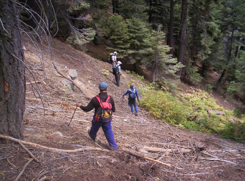
sidehilling down in the duff - picture by Nathan Holcomb
Eventually turning to a more SE direction, encountering only occasional brush, also a brief rain shower, we eventually reached Dillon Creek at the same place we had been earlier in the day. From there we contoured south back toward the trailhead, at a slightly higher elevation than in the morning and in so doing encountered markedly less brush. We reached the cars at 5.30pm, tired and scratchy.
The next half hour was spent discussing what to do on Sunday: reattempt the same route only starting much earlier (Steve's idea), attempting the west face of Moses Mountain (another new route) as originally planned, climbing Moses by the traditional east face (so as to guarantee at least one peak for the weekend), or attempting Dennison from the north via the South Fork Road (Jenkins has a parenthetical indicating this to be a route). After tallying up the pros and cons, a group decision was reached to go for Dennison again from the north. So we piled back into the cars and drove back down to the foot of Jack Flat Road, where we had a car-camp style dinner. We then caravanned out past Springville, then north on Route 65 then east on Route 198 to the South Fork Road. We reached the end of the 15-mile road Saturday night around 10pm and quickly hit the hay.
We were up in the dark and walking by 6.30am Sunday morning in perfect weather. The South Fork trail starts at 3700' and goes very steady; in two hours we reached Snowslide Canyon at 5800'. At this point the route leaves the trail and ascends this (now) dry, wide-open rocky canyon. Following Steve's lead, we started up the canyon, finding mostly clean solid rock and occasional class 3 moves, to about 6600' where the canyon splits.
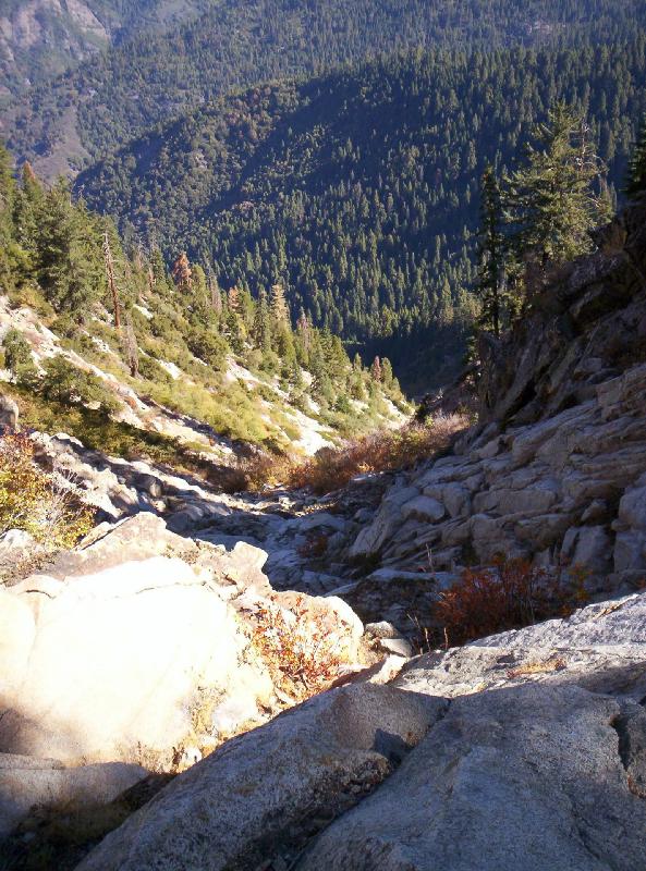
Snowslide Canyon - picture by Nathan Holcomb
We took the right-side gully, continuing up to about 7800' where we climbed to the right onto the rib on the right side of this gully, again encountering a couple of class 3 moves. The gully overall was mostly clean and solid rock. Atop the rib the peak came into sight, and we descended about a hundred feet to avoid very steep brushy rock then ascended up steep pine-needle slopes to the saddle immediately east of Dennison Mountain. Here we turned right onto the main ridge alternating right and left sides of the ridge, clambering over talus and through manzanita, to reach the summit at noon. Although the summit not totally bare, peaks such as Black Kaweah, Florence Peak, and Mount Brewer were visible.
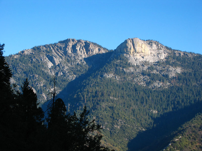
Homer's Nose (left) and Homer's Brow (right) - picture by Steve Eckert
As well, Homers Nose loomed across the Kaweah South Fork, and a broad sweep of the Central Valley was visible over 8000' below. The peak register showed this non-listed peak to be rarely visited. Enjoying our conquest, twice as sweet for yesterday's denied attempt, we lingered on the summit for an hour before descending the same way we had ascended. The steep canyon went fairly quickly, as did the trail. We got back to the cars just before 5.00pm tired but successful, a ~5000' gain day in 10 1/2 hours.
Greg Nichols adds:
In 2001, I wanted to climb to Dennison Peak, that jut of rocks below the mountain summit. I asked around locally and no one had been successful from this side but an elderly hiker. He gave me the route.
You park at Jack Flat where the rough campground is and below Dillonwood end of road. I didn't get my maps out of basement but I'm sure it is Jenny creek that comes into the campground. There is an old unmaintained trail going north up the creek line that we could still, with difficulty, discern. About an hour or so up you come to a large Indian bathtub,about 5 to 6 feet diameter. At that point the gulch clears up and you can see a clear ridge face on left(west) and on right(east). We chose to go up the right side and encountered some brush but pretty easy.
At the top where ridges reunited we realized we were above the peaks and about 200 feet below Dennison Mountain summit. We then dropped down about 800ft staying on the east side of Jenny gulch to the peaks which we got to. We then cut cross country in easy walking to Jenny creek gulch but turned off too soon into Backbone creek gulch. That gulch leads you away from Jack flats and comes out 2 miles below our car and is heavily brushy.
We came across a waterfall and drip hose. It was November 18 and the marijuana growers had harvested and left. They used the force of the waterfall to power the drip system. Because we didn't allow for the early dark(on the northeast side of that ridge it was dark by 3 pm) and we missed our gulch we were stuck out there overnight. We tried to walk for an hour after dark and fell into berry vines and rocks and got beat up pretty bad (worse by our wives the next day). Cleared an area and made a fire and took shifts tending it. Walked out below car and hiked back up road and home.
When I told the oldtimer about our success and stupidity, he laughed. He also fell into wrong gulch and also spent night out there but without fire. Anyway, as far as the mountain summit itself I would say it was a good route and we would have had it and back (you couldn't miss the way down from the summit) easily. I'm going up there Jan. 27 to get a little experience with winter condition hiking. I drove up there yesterday and hit snow one mile up rutted road. Hiked into Jack Flats and searched for old trail to summit. It was easier to see with 6 in snow on it. I will probably only try to get to Indian bathtub and consider doing some trail clearing and marking for next summer hike. If you want I will let you know how I did finding trail. Sorry I don't know how to write a report as well as you did. Hope it is helpful to you,