Despite a lack of book deals hanging on this walk, the walk looked like it could get the heartbeat up and the legs sore if done with spirit, so I decided to walk up the switchbacking road a ways, break trail, and head straight up the mountain through the band of trees and up the boulder field to the visible summit. Daring, I know.
During my walk on the road, I saw a metal tube swing gate warning people against unauthorized access. This set my mind thinking of old 1970s TV shows about secret things being done by bionic people on mountains. However, since no one "unauthorized" me, and since I figured I did not "intend" to follow the road all the way up, it did not mean I was seeking access by the road. I don't recommend YOU try this, but I did, and broke off of the road fairly soon, as intended.
Once in the trees, I couldn't see squat of the mountain, so I offset my course to err on the side of finishing slightly West of the summit, rather than East, since such a mistake appeared by the map to leave me with a slightly better approach, and give me a steeper workout.

The weather was even cooler under the trees, and I saw little white pellets on the ground and on the lichen covered rock occasionally jutting out of the forest floor to trip me. I headed straight up in accord with my sighted route below. (On my way down I noted these rocks could be slick, and avoided using them as stepping stones as much as possible, since I walked down the North side of the mountain and in the shade.) I wouldn't have gone through these trees if it wasn't such a straight shot by the contour map and by sight. It usually isn't, and fingers and undulations can throw you off without a compass, map, and/or GPS device. I made sure to angle right and West twice as much as the other way while navigating obstacles in the steep forest.
As I approached the end the tree line, the wind announced itself in the high branches above. I could see the boulder field ahead through the trees, and the darkness brightened considerably. I put my shades back on to save my eyes and zipped up my jacket to prepare for the exposure to wind.
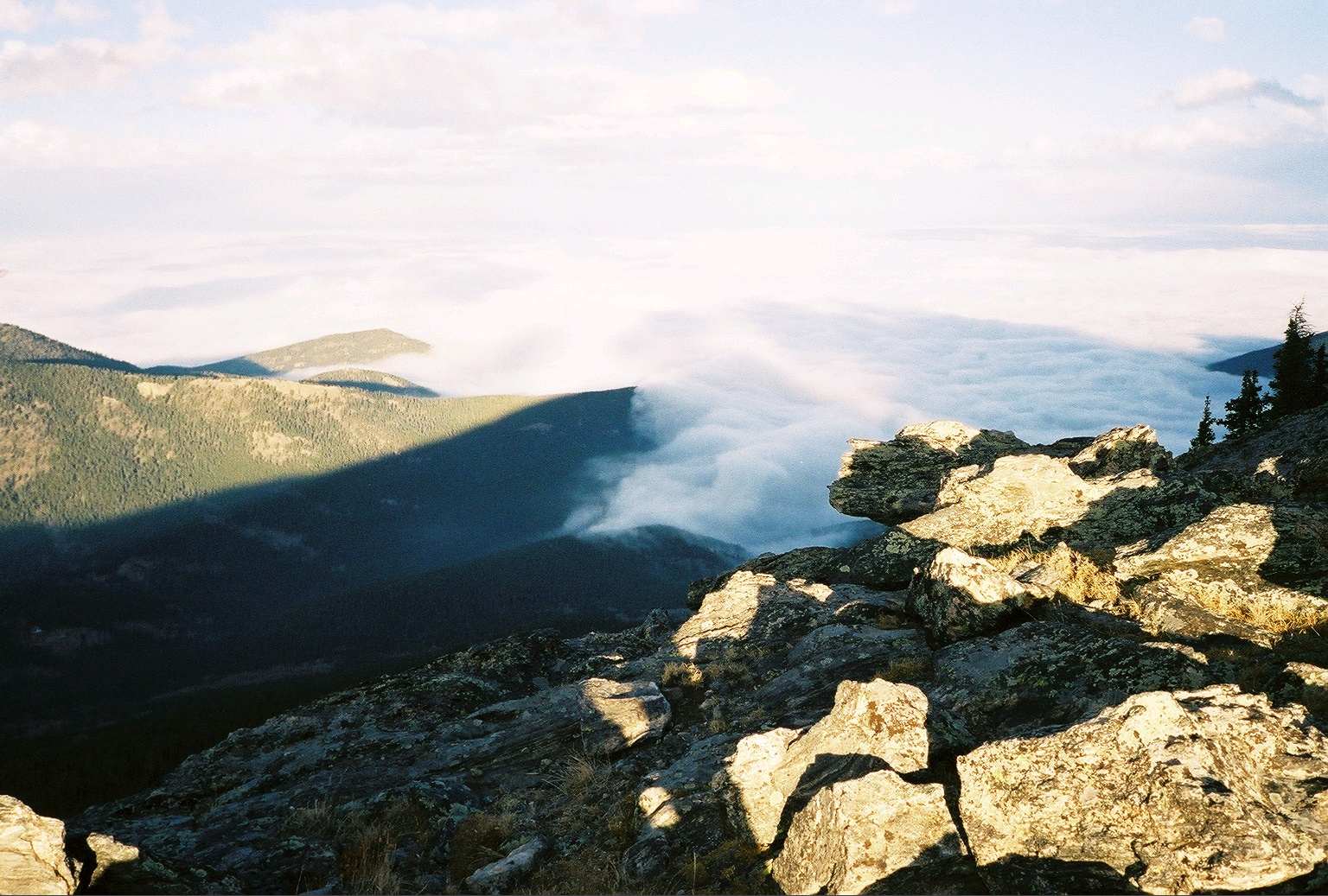
The moment of clearing is the most special part of a walk above treeline in a place you've never been. The view will be new. It was. What's more, what looked dismal and foggy in Denver was a bowl of soupy, mysterious white-grey cloud creeping up the mountain valleys and snaking into hollows beneath the mountain sun. It was like a lowland animal in the zoo of Denver you could view from the Rockies safely. It reminded me of a word I used to win the game of Dictionary once: pogonip. I think you need a weird dictionary to win dictionary.
As I walked up the boulder field I had to use my hands for balance and to test rock stability. I remembered how boulders can sometimes roll over on you, even if moving just a foot, and pin your body under crushing weight. So I approached them with extra care, even moderate sized ones, and as much as possible, traversed laterally with escape options. I tried to pay attention to what was supporting whatever I wanted to use for my support, and rule out boulders with questionable foundations. Also, I wanted not to walk on rocks appearing to support looser boulders and so trigger a small slide over me. Dying on a hike is not going out with a blaze of glory, and would actually be danged embarrassing, but you know it happens, so it pays to consider even hiking a dangerously enjoyable sport.
Proceeding carefully up the North side of Squaw Mountain's boulder field, the Eastern View opened to me gradually, and the sight of the fog spreading out over the city and plains made me forget there was a city there at all. I could see the afternoon's mountain shadows stretching out over the cloud layer on the plains in distinct points, exaggerated by the lowering angle of the sun descending toward the West over what I believed to be Mount Evans and Bierstadt, both visible from the Squaw Mountain Summit. More of a colleague of Squaw Mountain to the West was Chief Mountain, a slightly higher Eleveneer.
Once at the ridgetop, I did some scrambling about it's craggy terrain (this one's not a flat topper)from West to East. I had indeed landed to the Western ridge top, then scrambled my way to the high point where I took photos 360 degrees. It was a worthwhile shoot in every direction from Squaw Ridge, though you will get a radio facility and fire lookout tower in your picture depending on your direction and placement. I did not immediately recognize or identify Evans and Bierstadt, or exactly which was which, however, those two Fourteeners do dominate their surroundings. Chief Mountain lay out West beneath a bright sun. Denver was a bowl of pea soup. To the North were mountains as far as you could squint, and Squaw Pass down below, inviting the creeping fog. South I saw what I saw North but South, and some fuzzy white high clouds mixed with some dust in the air over faraway, unidentified peaks and saddles.
The wind picked up and blew almost continuously on me, motivating me to get positioned for lunch between some sheltering crags. Then, as I scaled down the Southern side of the ridge, I met two people coming up a perfectly good trail up the Southern side of the mountain. They looked not very spent. I felt superior for a moment, having braved the boulder field. I enjoyed chatting with them for a few minutes, asked them about their trail up and told them of mine. They were nice folks whose presence made light of yet another of my fantastical imaginings that I was the only person on that mountain on that day. There did not appear to be a soul at the fire lookout or the radio facility, and I would not recommend getting close to the radio relay facilities, instruments, gear or any of that stuff. That's only for bionic people, and even then, with permission.
With that, I looked around the radio tower facility, spied the fire lookout, and then took off back down the way I had come up. Squaw Mountain's old Fire Lookout station resembles a small castle tower perched out at the Eastern reach of the rocky ridgeback that includes the summit of this 11,486 ft. mountain. Go to www.firelookout.net/Individ_Lookouts/US500_Squaw_Mtn.htm [FileNotFound as of Sep 2008] to look at it and read of its history and use since 1940. There are several other sites about fire lookout towers including Squaw Mountain's.
As for GPS coordinates, I recommend checking the Fire Lookout sites for Squaw Mountain Colorado for some points of reference and calling the Arapaho National Forest Ranger District.