The trail starts in a National Forest, crosses into the Jennie Lakes Wilderness, intersects the trail from Marvin Pass, and ends up in Kings Canyon National Park by the time you get to Seville Lake. The Rowell Meadow area is very lush and wet, with a classic picture of Kettle Peak in the background, and hiking there via Rowell Creek is far better scenery than coming over Marvin Pass.
There doesn't appear to be a trail from the saddle (where you enter the park) to Seville lake, in spite of what the map says, so I had to hike up Belle Canyon to reach Seville Lake. BEAUTIFUL! All the lakes on this side of the crest are surrounded by glacier-scoured slabs and cliffs, and no one was there except a trail crew. They had cut 102 trees which had fallen across the trail this winter alone.
Seville Lake was a great place for lunch, but all good things must end... so I headed cross-country up the ridge that rises south from the east end of the lake. Great footing and long views including Table Mtn! Slabs, grass, tundra, and soon I was at the base of Ball Dome (9435', fifty feet of class 4 friction near the top). I walked around and tried a couple of approaches, but gave up for lack of sticky rubber soles. There is permanent water at the saddle, and this would be a grand place to camp if you wanted to catch a 360 degree sunrise or sunset from the top of the dome.
| 
|
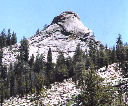
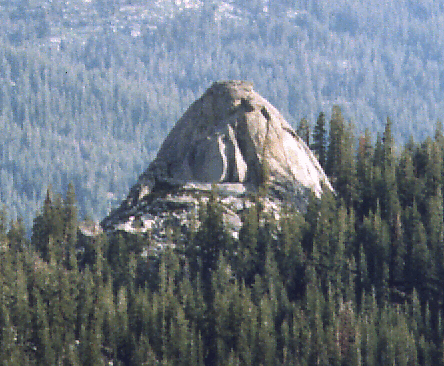
| Ball Dome's west face from the ridge near Lost Lake. | Ball Dome's south face from the trail between Ranger Lake and Silliman Pass. |
On to Lost Lake, where the scenery is EVEN BETTER!
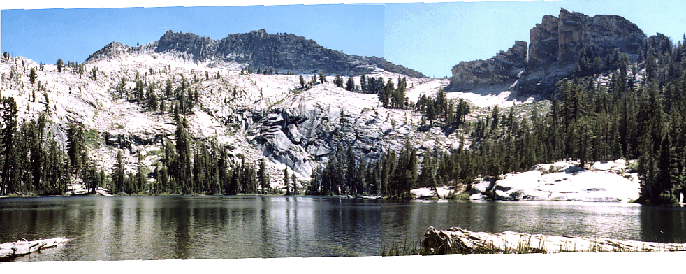
A panorama of the slabby cliffs southwest of Lost Lake.
There are bear boxes at all of these lakes (which I have dutifully logged and updated on Bear Box page), so it must be busy sometime... but I only saw 1 or 2 people all day.
Rather than drop way down on the trail, I once again cut across the ridge into the next glacial cirque (aka "Ranger Lake"). This was the trickiest part of the trip, but it remained class 2 (with a bit of hunting around) as I traversed an steep slabby area within 100' of lake level and popped over the rise north-northwest of Ranger Lake. The primo campsite here is at the northwest tip of the lake, in huge trees, near a bear box. I had the lake to myself, except for hordes of mosquitos which visited near sunset. I fell asleep to songbirds and a rising chorus of frogs, just before dark.
Oh, also, there WERE some hungry rodents around. I roused to hear my shoes being knocked around and brought them into the tent. Sadly, I didn't think about my ski poles: They are now shredded, with hundreds of deep gashes in the rubber grips and the nylon straps chewed almost in half. Salt deficiency, I suppose. Good thing I dragged my pack in the tent in my rush to get away from the bugs. Good thing I even HAD a tent, since I normally use a bivy bag. (The bivy was in the process of being replaced by Outdoor Research - the goretex delaminated after 6+ years, and they gave me a new one at no charge.)
Silliman Pass would have been a better place to camp than Ranger Lake: There were no bugs, no wind, great temperature, nice flat sand and rocks amid good trees, views of city lights to the west and deep into the High Sierra to the east, and cell phone service! Surprisingly, water is available within a couple hundred feet of the saddle (more so on the west side than the east side).
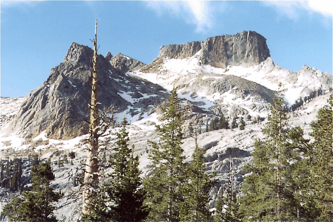
An extra bonus is the stunning view of Mt Silliman's north face as you climb the switchbacks from Ranger Lake!
Going down to Twin Lakes, I met a group being swarmed by mosquitoes: They were wearing head nets and swatting away, while I was relatively unbothered. My trick is to buy 100% deet in a pump mist bottle and thin it 4:1 with plain water. A good misting of your clothes before you put them on, including your hat and leg and arm coverings, minimizes your exposure and keeps your hands clean.
From here out it was almost boring. Twin Lakes is a slum, with horses staked to the trees and overnight backpackers milling around waiting for the pit toilet (which has only 2 sides, providing excellent viewing opportunities from the outlet of the northern lake). Now I was meeting people at least hourly, instead of daily, until I turned off at the intersection for JO Pass.
Now I'm wondering what the 'J' and 'O' stand for, since all the maps show it as 'JO Pass' but the signs show 'J. O. Pass' - probably the same 'J' as in Jennie Lakes Wilderness?? Anyway, the long views go away and the trail gets very faint in places, but it's a pleasant forested walk back to the western tip of Rowell Meadow and out to the car. No peaks climbed, but my other goal of visiting places I haven't been to was satisfied.
-- Steve Eckert
Robert Ayers adds:
Thanks for the report!
In September 1999, we found a "trail" most of the way to Seville Lake that was very odd: it looked like someone had recently tried to create a trail thru untouched woods.
We did Ball by two routes -- we did have sticky shoes and the works. The route at the left end (as seen from Seville, I think that's the north end) was trivial in stickies ...
In that area, there is also an interesting climb of "Sugarloaf", a bit further along toward Roaring River.
Thanks for posting the great road-maps to climber.org too!
Mark Adrian adds:
Your pix reminded me of my solo ascent. From the left/east side of the summit plateau, where it drops to that saddle south of Crescent Lake (RJ's east ridge route), I sincerely believe it is 3rd and not 2nd class, in fact, perhaps high 3rd comes to recollection (jeese, that was a few years ago).
Scott Carpenter adds:
Steve wrote : I'm wondering what the 'J' and 'O' stand for, since all the maps show it as 'JO Pass' but the signs show 'J. O. Pass' - probably the same 'J' as in Jennie Lakes Wilderness??
According to Peter Browning in Place Names of the Sierra Nevada, Francis Farquhar wrote in an earlier edition that Sam Ellis told Chester Versteeg that he crossed the pass in August 1889. He named it for the initials he found in the tree; cut some years before by John Wesley Warren. Warren had started to cut his name, but stopped after the first two initials. The correct name is JO Pass, not J.O. Pass