![]()
It seems the PCS seldom climbs these low elevation peaks, but the SPS website is littered with stories about how people came back at or after dark every night while trying to squeeze all three peaks (and sometimes adding Tower) into a 3-day weekend. I decided to relax a bit and add a fourth day. The extra time, a fun group, and a one-way route that covered new territory every day, all combined to turn what could have been a grunt into a great Labor Day weekend trip.
The trip REALLY started with multi-day discussions about how to set up a car shuttle between Saddlebag Lake (near Tioga Pass) and Twin Lakes (near Bridgeport). Careful reading convinced me that a short cross-country section with packs, between Saddleback and McCabe lakes, would allow us to do a one-way trip with no extra climbing and widely varied scenery each day. The gain from Saddlebag is the same as the gain from Twin, but there is a lot of downhill on the way in from Saddlebag. Another advantage of starting at Saddlebag is that you can get permits right at the lake (starting at 630am), and there is NO QUOTA even if you're crossing into Yosemite.
We took the $6 boat ride to save 2 miles of boring walk around the lake, and stepped into high alpine terrain dotted with little lakes. We went past Steelhead Lake, but should have went further west near Cascade Lake to avoid a few bumps. The low point of the ridge south of Shepherd Crest has a good use trail and a metal "Yosemite" sign, letting you know you're on the right route to McCabe Lake. Avoid the outlet of McCabe, going north around the east end of the 10400' contour, and follow either side of the stream in great tundra and duff until you pick up the trail just above 9400' on the south side.
We picked up the Pacific Crest Trail down in Virginia Canyon, and followed it into Matterhorn Canyon where we stopped for dinner before packing another hour into the hanging valley that holds Wilson Creek. This is big-tree country, and the only good camping along Wilson Creek is where the trail first approaches the stream (8900'). We were well over a thousand feet below our cars, and we had climbed over 3000' to get there! A warm and restful night lead to an early start the next morning. 3 hours of hiking got us to Smedberg lake, a shallow green spot surrounded by slabs. The swampy edges would be mosquito hell in the summer, but we were there after a few hard frosts and had no problems.
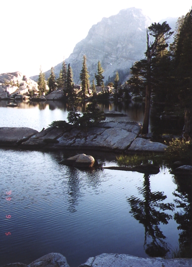
Tony rested while the other four hoisted day packs and headed for Pettit. We weren't sure we'd have time to do Volunteer that day, and wanted to get the furthest peak first. Well, everything can change, and we soon found ourselves scrambing up a little 3rd class (Roger's first), cutting below the lower part of the east face to the south ridge via the bench at about 9800'. The terrain between the peaks was "tortured" to say the least, and we wanted a high vantage to pick the best route. Volunteer is very scenic but not a very hard climb (see picture of Smedberg Lake from the summit), and was Roger's first peak from the SPS list.
The traverse to Pettit is not trivial, and we followed the advice of staying at 10000' as long as we could... but the traverse gets nasty as you approach the east end of Rodgers Lake, so we swung up to the 10400' saddle and followed the ridge south to Pettit. The register is on the middle bump, and the descent to Rodgers Lake can be done mostly brush-free. The high country east and north of Pettit is dotted with tiny lakes, and surely deserves a visit sometime in the future. (Andy Spellman had written "I could eat scrapple with hoagie oil" in the register - fill me in if you know what that means!)
Back in camp around 5pm, we headed to the outlet of Smedberg to camp. Tony had been visited by a ranger who thought our scattered gear represented a camp, and who was about to cite it for being too close to the lake. There was time for a dip in the lake, a large flat rock we could all cook on, the smoke from controlled burns was behind us, and we had time to pat ourselves on the back for a 3500' day with two peaks AND some backpacking.
Sunday morning, we ditched the trail and headed cross-country down the Smedberg drainage. The PCT goes up/down over 300' to avoid the slabs we enjoyed, and we picked up the trail as it switchbacked down through the 8800' contour line. Mostly downhill walking lead us to the Benson Lake turnoff, near where Linda took a surprise bath while crossing a shallow stream: Some of us waded the 4" sandy stream, but Linda had fabric boots and chose a nearby log instead. It turned out to have floating debris around it, which looked attached but actually hid a deep pool. Between two logs, up to her armpits in the pool, it took a bit of a tug to hoist her out. This was more surprising than dangerous, because the flow was very slow, but in fast-water conditions such a mistake could be costly.
We climbed the PCT until it leaves the drainage for Seavey Pass, around 8600', dumped our packs and headed to Piute's northeast ridge. If I do this peak again, I'll probably leave the trail at 8400', and diagonal south into the bowl east-southeast of the peak. There is a lake and some good trees there, neither of which show on the map. Going to the east ridge from this bowl, instead of hitting the ridge further north, would avoid most of the up-and-down climbing we did along the ridge crest. It would NOT avoid the tedious climb from the trail to the ridge, which is thin sage-type brush over talus.
All of us had chest/throat irritation from the aromatic plants we were walking on by the time we reached the ridge at 9700'. The view from here stopped us cold: We expected another class 2 slog, but were looking at sheer cliffs with no obvious path through them! Secor's book indicates there is a right (sandy) and left (vegetation) chute, but doesn't mention that both routes start at the upper right (north) corner of the permanent snowfield shown just below 10000' on the 7.5' topo. The left "chute" isn't a chute at all, it's a very steep ramp that turns sharply to the right and becomes a narrow exposed ledge behind a few trees. It's a great route for ascending, but we came down the scree chute because the vegetation seemed too hard and slick for an easy/safe descent. See the web photo for a picture of this face overlaid with the two routes: You can run the crest of the NE ridge all the way to the snowfield, or you can traverse the south side. Either way there are a few third class moves unless you make time-consuming detours.
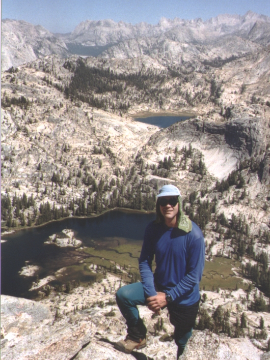
The big surprise came just after we hit Piute's north ridge at the saddle just below 10400'. Following this ridge is NOT second class, and you can't traverse around the hard parts because it's a cliff on both sides. The third class stretch is very short, and soon you're strolling across sand to the summit blocks. It seems the forest service was burning Deep Canyon or Piute Creek, with plumes of smoke rising from at least 5 sources. The only register entries this year were dozens of people from various trail crews, who felt the need to use an entire register page per person. It took longer to climb Piute than we intended, but it was the best climbing of the trip in terms of route finding and impressive granite faces. At 4000' total climbing (backpacking and peak climbing) it was our tallest day (but with the shortest mileage).
Back at the packs, where Tony had been waiting patiently, we stomped up the PCT toward Seavey Pass. Camp was at Lake 9000, again in the trees and again with time to take a dip and have dinner before it got dark. There is a picture of this lake on the web, which was almost as beautiful as the hidden 8800' lake we passed coming down from Piute (a bit north of where we went up).
The next morning I spent some time dispersing stacks of firewood and breaking up fire rings, then we popped over Seavey and headed "downhill" to the cars. Well, almost. It turns out that Peeler Lake is the high point of the hike out (1400' of gain)! It has two outlets and no inlets, but looking at the map I had been convinced that one stream flowed in and the other flowed out. Sigh. The terrain on the hike out was sometimes dramatic, but mostly flat and open in stark contrast to our entry route.
Around Barney Lake we started seeing "shore birds" - larger groups of clean looking people who weren't in great shape, meaning they couldn't be far from their cars. Did I mention it was hot? Mid-afternoon at 8000' in the full sun made Barney Lake's trees-and-breeze seem like heaven, and we took a long lunch there before gritting our teeth for the last four miles down to Twin Lake.
Walking into a mobile home park with restaurants and boat docks and barking dogs after several days in the backcountry is a shock to your sensibilities. We decided to have a late lunch, since Tony had finally gotten his appetite back. In a surprise turn of events, I didn't keep my lunch (or much of anything else) down, for reasons still unknown. Since we had to get back to the cars left at Saddlebag Lake, we were all crammed into Ron's Toyota pickup: my partners were kind (or wise) enough to give me the front seat, and Ron was good at stopping on command, so we made our way to Lee Vining in 5-mile increments without serious internal accidents.