RJ Secor announced a California Mountaineering Club trip to climb remote peaks from an unusual route as a two-week odyssey from Mineral King to Cedar Grove. Unfortunately, no one signed up and the trip got changed pretty often, finally settling into two one-week trips. I was planning to join him for part of the second week, but San Mateo County plopped an important public hearing right on the end of the trip so I wound up doing three peaks solo and joining him only on Glacier Ridge (see my Whaleback report for that day). This report covers the solo portion, climbing Kern Point and Picket Guard via Roaring River and Colby Pass. I left these two "orphan" peaks years ago when climbing the Kaweahs, and I tend to agree with RJ that they are either the most or close to the most remote peaks on "the list".
Most people access Roaring River by the dreaded Sphinx Creek / Avalanche Pass route. This takes you from 5k to 10k and back to 7k, then you can start climbing back up to 12k for Colby Pass or heading up Cloud Canyon. A far superior trailhead (which I had never heard of until RJ pointed it out) is Marvin Pass. This is the trailhead east of Horse Corral Meadow, and allows you to park at 8300' and climb only to 9200' before dropping along the Sugarloaf River to the Roaring River at 7100'. You can easily cover the 14 (mostly downhill) miles to the ranger station in a day, and many people make it all 20 miles to the entrance of Cloud Canyon (with about 3000' of gain).
Anyway, I drove to Grant Grove for a permit on Thursday morning, getting the 2nd of 25 quota permits and starting my hike in about 11am. I had dinner at the Roaring River, which was more Tinkling than Roaring in this dry summer, and hiked on until dark where I camped a few miles upstream from the ranger station. Two bear box locations were verified, and can be found in http://www.climber.org/eckert/BearBoxes.htm, again with text descriptions and GPS coordinates. It was so warm that I jumped in the stream after sunset, yet there were no bugs to speak of the entire day. Perhaps they fried in the 80 degree temps, or perhaps the gentle breeze was enough.
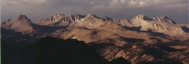
Kaweah Peaks Ridge From Milestone Bowl
Friday morning I packed over Colby Pass, caching several days food in a bear canister at the mouth of Cloud Canyon, and getting to the pass just in time for a late lunch. I stayed about 3 hours while a major storm blew over, hoping the long views would help me make a decision if it was safe to climb or if I needed to turn back. When the clouds cleared, Red Spur and Mt Kaweah were dusted white with snow, some of which was still there the next afternoon! I hurried down to the base of Milestone Bowl, finding great campsites at 11300'.
I traversed below the Kern Ridge toward Kern Point trying not to gain or lose elevation. The walking is fine slabs and tundra about half of the way, then you have to dip around a ridge and it's boulders and sand from there on. Kern Point is one of those peaks with a nice view and boring climbing, and with waiting out the storm I didn't summit until 7pm. Oops. Well, that's why we carry headlamps and a GPS, eh? Used 'em both, a lot. Round trip, the up/down elevation gain was about 500', making this a better choice than dropping 1000' down along the Kern-Kaweah River (if you're coming from Colby Pass).
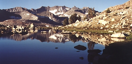
Kings Kern Divide From Kern Point
Saturday I got up late and eased down the "trail" (which disappears in spots, and is signed as "not maintained") to the K-K River toward Picket Guard. I crossed the stream as soon as the trail reached it, cutting around two granite prows and heading up the tree-covered slabs to the outlet of the lake at 3300m (10800'). The farther left (east) you traverse, the easier the walking is, making for a fine approach to the north ridge route on Picket (which is actually the eastern of two north ridges). From the lake, I stayed right of the drainage from Picket's northern face for better footing, then got on the supposedly third-class ridge just below the lake at 11400'.
Picket's north ridge is either hard 2nd class or easy 3rd class, depending if you choose to hunt for easy places or just storm straight up it. The climbing is very consistent for 700', making this a great "first" third class peak if you're in the area but not used to technical climbs. The summit block itself is probably 3rd class (in spite of the east ridge's 2nd class rating), but is only 6' high so it's no big deal (sort of like the north ridge!). A far better peak than Kern Point, I spent a long time dozing and gazing before dropping back down to Mosquito Alley... then up to my pack, over Colby Pass, dinner at Colby Lake, and back into Mosquito Alley #2 for the night.
Sunday morning I packed the rest of the way down to Shorty's Cabin (which does not exist) and then climbed Whaleback and Glacier Ridge (as detailed in my Whaleback report). Monday was just a long pack out. Every day of the trip had different clouds, but it only rained on Friday. Lots of big tall clouds for a dry year! There were lots of backpackers along this route, but no one climbing any peaks. Several of them mentioned losing the trail between Cloud Canyon and Colby Lake, but none of them seems to know where the horse's hoof (complete with horseshoe) came from. It appears to be a grim reminder that the Colby Pass trail really is NOT maintained, and really is NOT suitable for pack stock!
Datum,North America 1983,GRS 80,0,-1.6E-7,0,0,0
RouteName,1 ,PACK TO SHORTYS
RoutePoint,D,PACK0,36.7408993967,-118.7381477562,08/07/1999,17:10:31,MARVIN PASS TH
RoutePoint,D,PACK1,36.7421999835,-118.7321299752,08/07/1999,17:11:12,
RoutePoint,D,PACK2,36.7379999836,-118.7347599753,08/07/1999,17:11:20,
RoutePoint,D,PACK3,36.7343383863,-118.7358034248,08/07/1999,16:03:31,28-JUL-99 18:42
RoutePoint,D,PACK4,36.7308383890,-118.7347640304,08/07/1999,16:03:32,28-JUL-99 18:42
RoutePoint,D,PACK5,36.7176143897,-118.7377244079,08/07/1999,16:03:32,28-JUL-99 18:42
RoutePoint,D,PACK6,36.7126500445,-118.7275797722,08/07/1999,16:03:32,28-JUL-99 18:42
RoutePoint,D,PACK7,36.7155843811,-118.7092549202,08/07/1999,16:03:32,28-JUL-99 18:42
RoutePoint,D,PACK8,36.7110138970,-118.6881995795,08/07/1999,16:03:32,28-JUL-99 18:42
RoutePoint,D,PACK9,36.7164212303,-118.6719400284,08/07/1999,16:03:32,28-JUL-99 18:42
RoutePoint,D,PACK10,36.7277777031,-118.6417222615,08/07/1999,16:03:32,28-JUL-99 18:42
RoutePoint,D,PACK11,36.7285823658,-118.6140901443,08/07/1999,16:03:32,28-JUL-99 18:42
RoutePoint,D,PACK12,36.7201548652,-118.5945904848,08/07/1999,16:03:32,28-JUL-99 18:42
RoutePoint,D,PACK13,36.7121592031,-118.5857123586,08/07/1999,16:03:32,28-JUL-99 18:42
RoutePoint,D,PACK14,36.7130684690,-118.5856587289,08/07/1999,16:03:33,28-JUL-99 18:42
RoutePoint,D,PACK15,36.7073929148,-118.5799295305,08/07/1999,16:03:33,28-JUL-99 18:42
RoutePoint,D,PACK16,36.6999578315,-118.5601455569,08/07/1999,16:03:33,28-JUL-99 18:42
RoutePoint,D,PACK17,36.6719072899,-118.5358018281,08/07/1999,16:03:33,28-JUL-99 18:42
RoutePoint,D,PACK18,36.6601323924,-118.5311937932,08/07/1999,16:03:33,28-JUL-99 18:42
RoutePoint,D,PACK19,36.6500365578,-118.5342944269,08/07/1999,16:03:33,28-JUL-99 18:42
RouteName,2 ,PICKET AND KERN
RoutePoint,D,COLBY0,36.6471075856,-118.5344231729,08/07/1999,16:03:33,28-JUL-99 18:42
RoutePoint,D,COLBY1,36.6316741550,-118.5216880447,08/07/1999,16:03:33,28-JUL-99 18:42
RoutePoint,D,COLBY2,36.6321301306,-118.5158140069,08/07/1999,16:03:33,28-JUL-99 18:42
RoutePoint,D,COLBY3,36.6183703985,-118.5011530526,08/07/1999,16:03:34,28-JUL-99 18:42
RoutePoint,D,COLBY4,36.6129201498,-118.4947157510,08/07/1999,16:03:34,28-JUL-99 18:42
RoutePoint,D,COLBY5,36.5955447999,-118.4858805547,08/07/1999,16:03:34,28-JUL-99 18:42
RoutePoint,D,COLBY6,36.5764903873,-118.4742719543,08/07/1999,16:03:34,28-JUL-99 18:42
RoutePoint,D,COLBY7,36.5912371723,-118.4722495685,08/07/1999,16:03:34,28-JUL-99 18:42
RoutePoint,D,COLBY8,36.5966874210,-118.4448052058,08/07/1999,16:03:34,28-JUL-99 18:42
RoutePoint,D,COLBY9,36.6102164831,-118.4922695764,08/07/1999,16:03:34,28-JUL-99 18:42