In the summer, the Three Sisters area near Bend Oregon is covered with fisherpeople and hikers. The temperatures are warm, the peaks are around 9-10k, and the weather is good. In the winter, however, the roads are buried under snowdrifts and you can have the place to yourself (especially mid-week when the snowmobiles are gone).
Following successful climbs of Mt Hood and Mt St Helens with Harris and the PCS, I headed off to visit friends in central Oregon. (I briefly considered Adams, but with roads closed by snow at 3k and the peak over 12k, the 7 miles of road PLUS the climb were more than I wanted to do solo.) The highest of the Three Sisters is South Sister, so as a peak bagger that's the one I had to do.
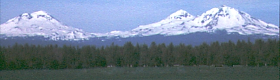
Three Sisters from the east
Routes on all three are described in "Oregon High" by Jeff Thomas and "Summit Guide to the Cascade Volcanoes" by Jeff Smoot. The Smoot book may be more complete, but each have their strengths. Even more valuable is the "Three Sisters Wilderness Map" published by Geo-Graphics in Beaverton Oregon - it has a large scale map of the area with roads, and a flip-side topo showing trails and campgrounds in good detail.
ODOT had 6 snow blowers cranking away on the Cascade/Century Highway the day I was there. They were making a mile or two per day, and planned to keep the road closed at the Mt Bachelor ski resort until the rest of the 100-mile loop was cleared. I spent some time talking with some ODOT workers on their lunch break, and they said as long as I was alone and picked a wide safe spot to park I could quietly ignore the roadblock. I don't recommend assuming this will always work, but being nice worked for me this time. It probably helps to not have a big caravan of cars and maybe to have out of state plates.
At around 4am I drove up the deserted road to where a snowplow blocked it, about 4 miles in. That reduced the day to 16 miles (instead of an impossible 24), but to my surprise that spot on the road was 1000' lower than the roadblock at the ski resort. Bummer. Now it was a 6000' day and the fog was rolling in to cover the pre-dawn stars.
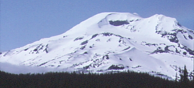
Three Sisters from the semi-closed road
I planned to head up Hell Creek from Devils Lake, but never found the trail among stunted trees and sharp snowdrifts. Instead (in the fog and dark) I angled too far left and wound up below Kaleetan Butte. Bummer number two. Rather than go back into the small close trees, I opted to stay in the big trees where I could ski easily... this added over a mile, but at least I could move quickly and knew about where I was. Without a GPS, I would have turned back due to 200' visibility. As it was, I had to check a compass every 2-3 minutes to avoid being turned by the lava flow and moraine bumps. It's hard to pick an efficient route when you can't see the terrain! Climb or traverse?
I broke out of the low-lying fog at about 7000', realized I had gone on the wrong side of Little Broken Top, and climbed steadily as I traversed to the south ridge. The sun dried my soaking polypro immediately, and the snow slushed up without sticking to my climbing skins. Not bad, but it did not last. At least I had a chance to scope out the crux of the climb, which is bypassing the cornices and bergschrunds at the edge of the Lewis Glacier. There was one other set of tracks, which lead to a snow cave around 9000' - otherwise there was no sign that people had ever been here. Solitude. It was nice after the cattle drive on Mt St Helens (400 climbing permits for one day there, at $15/head).
Non-technical routes on volcanoes always turn into stairmaster events. This one was no different. Now that I could stay on a well defined ridge, there was no need to check the map or the GPS. The altimeter moved slowly, and once again in the clouds/fog my enthusiasm was waning. Imagine my surprise when I reached a shoulder on a peak that was not supposed to have one! The crater has 300' of snow drifted into it, filling the hole completely and making the rim traverse into a follow- the-GPS walk over to the high point.
As I ate lunch, the clouds drifted in and out, and I got fleeting views of Broken Top, Bachelor, and the other Sisters. Much more scenic than Helens and Hood, since there were other close mountains to see from new perspectives.
Bachelor From Three Sisters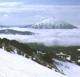
|
Broken Top From Three Sisters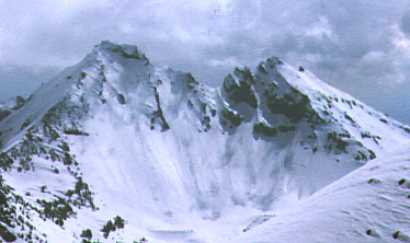
|
I skied the whole way down, with a few kick turns at the top (because I'm not a hot-shot skier). Bypassing a cornice where car-sized chunks had rolled into the valley, I glided down into the drainage north of Moraine Lake with some of the best skiing I've ever had. The snow was a deep slush, with no ice patches or fast spots. Oddly enough, it turned well in spite of how heavy it seemed. With no trail in sight, I followed Goose Creek down to Sparks Lake, detouring easily around at least a dozen tiny waterfalls that added to the beauty of the trip. Before I reached the road, the sun had burned off the clouds, and I finally got a good look at the summit - and my ski tracks visible 5000' to the top. 12 hours well spent.
![]() Download the Waypoint+ data below as a GPX file for your GPS.
Download the Waypoint+ data below as a GPX file for your GPS.
Datum,North America 1983,GRS 80,0,-1.6E-7,0,0,0
WP,D,BACHEL, 44.002180696,-121.6668033600,05/20/1998,22:49:05,MT BACHELOR TURN
WP,D,CAR-SS, 44.018424238,-121.7205335386,05/20/1998,22:49:29,CAR ROAD CLOSED
WP,D,MORAIN, 44.073420168,-121.7683786992,05/20/1998,22:50:39,MORAINE AREA
WP,D,RDGCRK, 44.081037642,-121.7727828864,05/20/1998,22:51:17,CREEK W OF RIDGE
WP,D,SISSTH, 44.103514553,-121.7693067435,12/31/1989,00:00:00,SOUTH SISTER
WP,D,SISMDL, 44.148210884,-121.7839408759,12/31/1989,00:00:00,MIDDLE SISTER
WP,D,SISNTH, 44.166272880,-121.7724395636,12/31/1989,00:00:00,NORTH SISTER