In keeping with a tradition, that nobody knows the origins of, not even myself, that dictates that I give all of my climbing trips a name, even if trivial or even down right silly, my adventures on Sunday the 19th have earned the name The F'd Up Trip. This is most decidedly April's edition of Don't Follow Pat's Route.
On Friday I got a frantic e-mail from Rich Calliger I abandoned plans for Aggasiz & Humphries in Arizona and decided to joing Rich and Arun Mahajan for what I termed the Galactically Boring Alta Peak. I tried numerous times to phone Rich on his way down to Visalia but each time I got the dreaded The person you are trying to call either has not activated the roam feature or is a figment of your imagination... recording! I decided still to meet them for Alta on Sunday and solo it if I could not locate them.
After catching AMP on MTV, I finished packing and headed up 180, leaving at 12:10am. As I neared the turn before the junction with 245, I noticed that I could see what looked like the whole valley below, so I pulled into a turn out to see what I could see. Far away was Porterville, with 65 with traffic visible, even at 12:40 in the morning. I could see all of Visalia, and I could almost make out 198 through tulare and over to Lemoore. Fresno at night is even bigger than by day, seemingly with no limits. I could make almost all of the major areas. It was so clear I thought I could see the individual buildings downtown. The airport lay behind Jessie Morrows Mountain far below (where home is!) but I could still see little lights from the planes ducking down behind the hill. It was awfully clear, but I thought nothing of it...
I drove through the gate at around 12:50 and continued on down the General's Highway and made the left to Wolverton. I parked right next to the trail head so that I could catch Rich and Arun on their way up,made some last minute packing changes and then finally went to sleep at 1:30.
I woke up at 6:30, a little bit too late. I probably missed them but decided to try and catch up. It was crisp but not cold. The snow was firm, but not icy. I took to the trail about 7:10, after making one last parking lot check for other PCS'rs. The snow was terrible. It was so soft that it was slippery. It might as well have been completely iced over. I trudged through the sludge slowly, with all hopes of catching up completely abandoned. I probably could have doubled my time with crampons on but was too lazy to strap them on. I made Panther Gap at 5 till nine, an absolutely horrendous time.
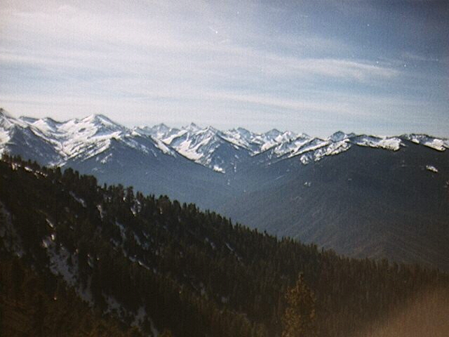
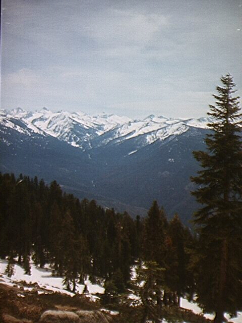
Living so near, I had never actually bothered to hike Alta. I used to see it at least 20 times a day, and had grown so accustomed to it poking through the smog that over time I lost all interest in it. The only reason for my even being there was Rich's suggestion that the quality of the company is more inportant than the quality of the peak which I thoroughly agreed with. The company was non existant but the views more than made up for the lack of companionship. After hiking a minute up the ridge to Panther Peak to find a snowless rock, I walked out to the edge of the cirque (or cirque like formation) and was rewarded with one of the most impressive views of Mineral King I had ever gazed upon. I am obsessed with Mineral King and so just to be able to get some more photos was well worth my time. The peaks were all snow clad, some with little wisps blowing from the summits. Castle Rocks were still snowed in, except of course the pinnalces! I could see from Lippincott all the way down to some roundish peaks that were so far south that I would guess them to be in Mountain Home or the very southern tip of Sequoia.
Florence, Vandever, Empire, White Chief, Hengst were all there before my eyes in the perfect clarity that snow creates. The most impressive site of the whole day was that of Sawtooth Peak, the king of Mineral King. Sawtooth is probably (when it can be seen through the smog) the most striking peak of all visible from the valley. From Panther Gap it is even more impressive. On this day the south slope was still clad in a thick coat of white, but the north face was dark and imposing. Little wisps blew off the tiny summit. I added quite a few pictures to my collection of Sawtooth photos.
After a quick bite, I heard some weird noises and a quick investigation revealed two snow campers just getting up! I asked if anybody had come through earlier and they indicated that they heard some noises late at night but nobody today. I then headed up the ridge, trying to follow the route of the trail. Here is where the fun begins. The snow was completely iced over just a few feet above the saddle so I stopped to put my crampons on. I then noticed some prints in the slope above with the tell tail outline of crampon points in the front. I followed them uphill for about 400 feet (above where the trail should have shot off) and then lost them. So I continued uphill, not being able to spot any trail makers, all the while my left crampon popping off every 5 minutes.
Two and a half hours later I stood triumphanly on top of........Peak 9975!.......Where the F' was I? After walking for a few feet out of the trees Alta Peak stood right before my eyes, with only 1000 feet and a class 3 ridge separating me from my goal. This of course was not the way I intended to go, especially if I wanted to catch up with the other guys. The numerous pinnacles and turrets projecting from the snow along the ridge would have made a solo traverse a deadly one, and with that thought in mind I headed down to Mehrten Meadow, carefully looking for the tracks that would have announced anybody else's presence, but with no luck. At 12:30 I stopped for lunch where the trail crosses the creek. While eating I began to witness a most interesting phenomenon. Clouds from the valley were blowing into Middle Fork Valley and up the sides of the canyon, similar to what the fog does. More interesting was the fact that as the clouds gained altitude they grew larger and larger. I sat for over half an hour watching the clouds. Soon Tharp's Rock was obstructed, only the small southern pinnacle visible.
What the hell was I thinking? I should have been running back upslope as fast as possible following my exact route. Instead I sat and watched the clouds as they first filled up the valley and then began pushing over the Great Western Divide, with only Sawtooth still visible. At 1:30, I had this terrible feeling in my gut. I had abandoned all plans to summit Alta when I realized I had climbed 9,975. I headed up trail, with crampons still on, trying to avoid the larger rocks. As I rounded the bend into the Panther Peak cirque the trail disappeared completely. Of course Murphy's law also dictates that when you are climbing solo and the trail disappears, a freak storm must also hit.
Although Alta peak may be somewhat boring, the trip there is completely wild, especially with no trail. A wall of imposing clouds lay before me and in no time at all they completely engulfed the mountainside. Visibility was down to 20 feet and I was supposed to traverse a mile of cirque headwall with no trail. How fun! I waited for the clouds to leave, but after a few minutes and no change in conditions, I decided to head north along the slope, trying to head in the general direction of the trail before I lost it. It was easy going for a while, but soon the slope steepened, approaching 60 degrees in spots. And as the southerly exposure increased as I rounded the bend, the vegetation seemed to increase exponentially. Now, instead of 45 degree snow and rock, there was 60 degree snow, wet rock and of course the ever popular Manzanita and Chinquapin.
With crampons still on and ice axe in hand I continued the tedious and delicate traverse. The worst was most definately the Manzanita, but the Manzanita Mombo which consists of plunging, thrusting and diving headfirst through the brush worked perfectly. The Chinquapin was almost always perched perfectly along the sides of the rock, which for the most part consisted of high angle slabs with very few cracks. The clouds made the exposure seem much worse than it probably was because I could only see 10 feet down the chutes and then there was total nothingness. About two thirds along the traverse was a giant rib, lined with boulders and surrounded on both sides by more wet slabs. This was the worst part of the whole traverse. The chutes were too wide to make use of the Chinquapin for holds, so I took off the crampons and stowed them, and hunted up and down the side of the chute for a way accross. Finally, about 150 feet above where I met the chute I found a small ledge, only wide enough for barely one of my shoes, but it would have to do. I took a deep breath and then moved accross slowly. Of course the clouds dissipated slightly while I was on the ledge just to let me know that I was really at the top of a bottomless pit. I then had to search for a way accross the rib, and then had to find a way accross the slabs on the other side. While hunting the clouds lightened up just enough to make the presence of the trail known, about 100 feet below. I made my way accross the slabs by sitting on by butt and leaning back while grasping for any small holds I could find for balance. Once across the clouds thickened again and I was left to find the trail with only 10 feet of visiblity. Just to add one more thing to the list of evils trying to keep me from reaching my car, Buck Brush replaced the Manzanita as the dominant shrub. Nothing could have been worse. I was almost at the trail, and very carefully made my way through the needles, doing the Buck Brush Ballet which consists of holding your hands high in the air and jumping accross branches and anything else that will keep the needles from piercing your tired flesh. At last, I reached the gully before the next ridge south of Panther Gap. Of course Murphy's law dictated that the trail lie 10 feet above. It was now 3:45 and I was just about fed up with this rock and brush thing. I was separated from my car by a mere 10 feet of buck brush (and 4 miles of trail) so I swallowed my pride (and a million advil), grasped the branches and climbed the slope. The last hurdle was the nearly vertical side slope of the trail itself, which proved to be the most difficult. None of the vegetation along the rim was actually rooted. It was all clippings from last year's trail maintenance. Nothing would hold so finally I just jumped....managed to get one bloody hand on a rock in the trail which I used to pull my tired body up the rim.
I followed the trail for about 5 minutes and then it petered out again. The 10 feet of visiblity wasn't helping at all. The trail seemed to head west, but I couldn't find my footprints. Knowing that this wasn't the ridge to Panther Gap I continued north. Finally I found my footprints and followed them back to the car. Of course by the time I made it to the junction with the Lakes Trail the sky began to clear up. Had I just waited I could have probably found the trail again and walked it along the cirque and taken all of 15 minutes to do it, but the cross country route was certainly less boring. One thing to note is that once the trail reaches Panther Gap there are no longer any trail markers. This would have made everything much easier.
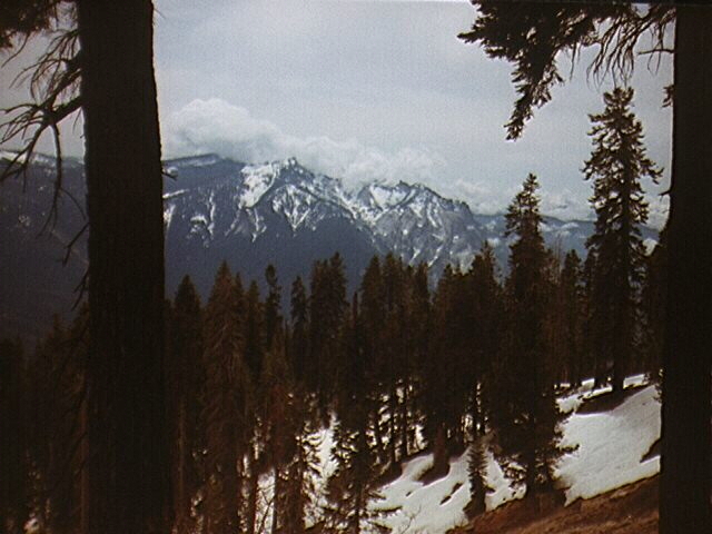
I arrived back at the car at 4:45, almost 9 hours after I began! I changed clothes, then stopped at lodgepole for a soda and then drove the General's Highway as it snaked through the towering Firs and Giant Sequoias. As I rounded the corner after the Montecito resort I could see over my shoulder towering snow capped peaks jutting from the clouds. I stopped to get a closer look. After a couple of minutes the sky started darkening while the peaks seemed to glow more. I grabbed my cameras and climbed to the treeless top of a small dome just in time to catch the moon rising between Mt. Silliman and Kettle Peak. All of Mineral King was now above the clouds with Sawtooth asking for all of the attention. From my small perch atop the rounded granite slopes I saw something I had never seen before, the entire Alta ridge with no less than six snow capped pyramids along its length. The setting sun and dark clouds made the peaks glow with a brilliance that I had never witnessed before.
Photos: