I've been looking up at Marcus Baker from the highway on and off for over 20 years. When in high school, I even bought the topo maps and tried to plan an expedition. We figured it would take about two weeks to traverse the broken ice fields, and then we were not sure what the climbing conditions would be like on the main mountain.
In July 1996, I was back in Anchorage (Alaska) for a high school reunion and decided to take another look at Marcus Baker (the high point of the Chugach Range). This time I had the money to hire a guide, however, which changed the trip dramatically! I did not have to pack food/tent/rope/etc, and the guide knew a pilot who could fly us over the ice fields onto an 8000' snowfield at the base of the summit ridge. Two of us each paid the guide about $600 and the pilot about $300, so this was not a low-budget trip. On the other hand, the guide's knowledge of snow conditions and routes was invaluable. There are no guide books for the Chugach mountains!
Staeheli had tried this peak before, but had never quite summited due to bad weather and/or bad clients (his version of the story). Most of his clients must lie to him about their physical abilities, because he figured that climbing from 8000' to just over 13000' would require a five day trip! He scoffed at me when I said that even climbing in snowshoes, my estimate was more like three days plus weather layovers, if any... so we compromised on a four day trip.
The first day we had to wait in line at the air taxi hanger, because a large group of Japanese tourists had shown up unexpectedly, and it is obvious that half-hour sightseeing tours bring in more money than lugging climbing gear up 8000' and landing on a snowfield! We finally set down at our target site long after noon, roped up, loaded the sleds with half our gear, and watched the clouds build while we had lunch. The hike to high camp took 5 hours (not 2 days as Dave had estimated) and we started setting the tent up around 8pm in wind and light snow.
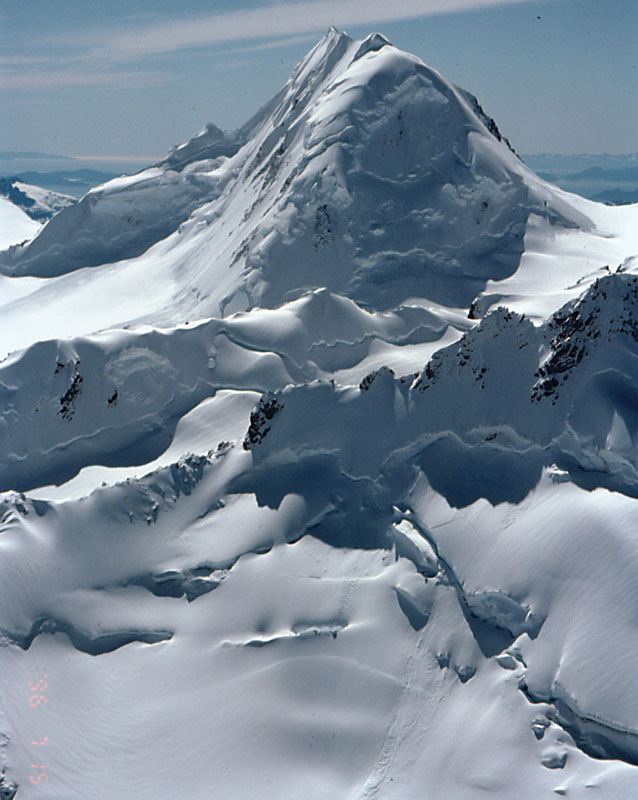
Mt Goode from the Plane (click for larger image):
In July, in southcentral Alaska, the sun sets around 10pm and rises again around 2am - and it's so close to the horizon that you don't need a flashlight even at midnight. There is, therefore, no reason at all to get up early in the morning or go to bed early at night!
The snow at high camp was fluffy enough to cut blocks with a large snow shovel, which we stacked up as a wind break for the tent. All night the snow piled up on the tent until the wind knocked it off in slabs. We were not optimistic about summiting, but by the end of breakfast (9am) the sky was clear and the wind had died down!
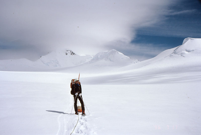
On the ridge above camp (click for larger image):
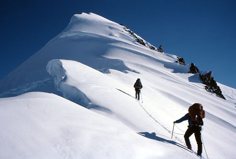
Our route along the ridge proved fairly easy except for two sections that required front-pointing on ice, and several hidden cracks loosely drifted over with soft snow. We used belays in several places, but I did not feel that we really needed them. (Guides must be overly cautious, or they never get very old - Staeheli's partner was afraid of walking on cornices, but died while walking UNDER one.) At the base of the summit mass, however, we found ourselves knee-deep in snow that balled up on our crampons. Under this was a layer of ice in places, all at angles that measured over 40 degrees in places.
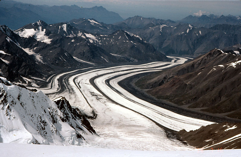
The Marcus Baker Glacier (click for larger image):
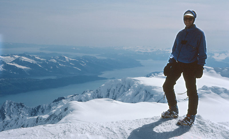
As we climbed, salt-water fjords came into view. I have never been at altitude, on ice, looking down at continuous slopes into an ocean! The weather was holding, but as we neared the summit we lost sight of Denali (formerly McKinley) behind distant clouds. From the top, however, we picked up views of Blackburn, Sanford, and Mt Saint Elias - which means that from the top of Marcus Baker you can see every really high peak in the state... and it's a BIG state, too.
Prince William Sound From The Summit (click for larger image):
Great visibility kept us on the summit for around half an hour, but the wind and the mid-afternoon hour finally convinced us to leave. The walk back to camp was mostly uneventful, except when we found an old rappel anchor (two poorly-installed pickets) near one of the pitches we had front-pointed with crampons. Oh, yes, there was that one last crack we had to cross within sight of the tent...
That crack (not really a bergschrund) had a four-foot-thick snow bridge which had held our weight in the morning. While testing in on the way down, I felt it give. I yelled something unintelligible (certainly not "falling", as I should have) and began scrambling to stay on top of the moving blocks. This was the softest styrofoam snow I have ever been on (or in), and everything was moving in slow motion. Each block that I tried to step on cracked in half and went further down the crack. I wound up half-supported by the rope and half resting on snow, and was able to climb out without a rescue. My partner was in a self arrest holding the rope, while the guide was flitting about nervously watching the whole affair. He still insists he's never had a client fall into a crevasse, but now I understand that his record is attainable only by carefully defining everything as NOT a crevasse.
The next day we started hiking down the glacier somewhere around noon (why rush?), wondering if the pilot would be in the area with a sightseeing group. Otherwise we had 24 hours to sit and wait with nothing to do. The weather was questionable, and we heard no engines, so the evening was spent napping and pondering imponderables (such as the nature of religion and what to have for dinner).
Parting Shot Packing Out (click for larger image):
The next morning the guide and I took off for a nearby bump to get a view of the Radcliffe and Harvard glaciers. The climbing was more exciting than the day before due to knife-edge ridges with horizontal cracks and apparent cornices above eroding rock slopes. The summit bump has 1100' cliffs on 3 sides, and qualifies as a first ascent under Alaska's "it's a peak if it's 1000' down on every side" rule. We're looking into registering a name with the Mountaineering Club of Alaska, who keeps the official log of first ascents. If possible, it will be called Rose-Hulman Peak (after my alma mater) in keeping with the other college-related names of the area.
After a couple of hours in camp, and 30 minutes in the plane, we were back at sea level again. This trip convinced me that there is no need to leave our country for truly high-altitude mountaineering. This far north the 13k peaks have snow conditions that might not be found below 22k in other places, but you can eat the food and drink the water when you get back to town!