
After working the entire weekend and most of the morning I decided that I needed a break so I whipped out my wilderness map and started hunting. I wanted something big, but didn't want the long drive to the Owens Valley. For reasons unknown Sawtooth struck me as being the best choice. There was also going to be a full moon this night so I thought I should take a stab at a moonlit ascent, afterall Whitney was easy.....
Having decided on an overnighter, I phoned the back country office. No answer. I kept calling for three hours and still no answer. I then phoned the main office and after I calmed down I finally got a hold of the Mineral King ranger himself. He was the most helpful ranger I've ever had the pleasure of dealing with, although he refused to give me a permit over the phone because the law requires that I sign it in his presence or something like that. It was now 3:00pm. I had no food, no gas and had to be up at the ranger station by 5:00. Not possible you say....
DISCLAIMER
Any references to exceeding posted speed laws either express or implied are completely ficticious.
As soon as I was off the phone, I through my pack and gear trunk in the Corsica and raced to the market in Reedley, where I picked up the much needed munchies. One more quick stop at the gas station and I was off. J19 is usually well patroled by our highly esteemed state law enforcement agency but I decided to take a gamble anyway. At 4:15 I was on Mineral King Road and began "the drive". The toll booth closes at 4 so I was safe from that delay. Secor reccommends a full hour and a half to drive the drive....
Exactly 48 minutes later I drove past the ranger as he was leaving (well I was 3 minutes late). He wasn't in a marked vehicle but something struck me about him and so I stopped. I guess he had the same reaction, because he stopped as well. After the inital "are you...." thing, he offered to open the station back up and give me my permit on his own time. This guy was great. He took out the stack of maps (All those who have been in the Mineral King ranger station know the stack...) and after digging for what seemed eternity produced Sawtooth's quad. He suggested that I take the longer trail to Crystal Lakes and mentioned that there would probably be a snow free bench near the bear box at Lower Monarch Lake. I signed on the dotted line, thanked him profusely and was off. The Timber gap trailhead was half empty. oddly though all of the cars there had these amazing chicken wire contraptions on their undersides. Could their really be Marmots in Mineral King? Naaah...
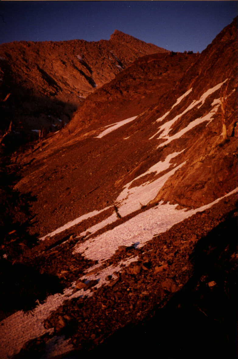
The sun was already getting low so I packed faster. I covered my gear trunk with a tarp to disguise its resemblance and locked up. I was on the trail at 6 with an overly heavy pack. The grueling slope to Groundhog meadow seemed like it would never end but an hour later I was there. After hunting for a place to cross the creek I regained the trail. By 8 I was on the north slopes of Mineral Peak, where I witnessed one of the most spectacular sunsets I'd ever seen. The sun was just dropping behind Paradise Peak and by the time I had my camera ready its dark red disk had moved north and was now framed by some of the jagged Castle Rocks, which made for some excellent photographs. To the east Sawtooth Peak, now larger than life was actually glowing a brilliant red, its bright white granite standing out from the surrounding metamorphic rocks of Mineral King. After a few more snapshots I trudged on towards lower Monarch Lake. As the elevation increased the snow patches became snow banks, and when I reached the outlet stream of the lake, which is NOT the water source of Monarch Creek as I discovered. There was a large stream actually flowing out of the side of Mineral Peak, perhaps a large spring fed by upper Monarch Lake? After making the two stream crossings I found myself on the bench and found the snow free flat the ranger had recommended. I quickly made camp, filtered water and put my food in the bear box. I then relaxed as I watched the last glimpse of sunlight disappear and the lights of Visalia appear 10,500 feet below me.
My plan was now to start the climb when the moon was shining enough light on the south face of Sawtooth for me to see the trail to the pass. When the time came I awoke and quickly found that the trail dissappears on the far side of the bench. I decided to play it safe and wait for some sunlight, which came at 4:30am. I again followed the trail until it disappeared and then tried to follow my map and headed up slope. I found what looked to be a trail and followed it. I soon discovered that the entire southwest face of Sawtooth was sand and cliffs, and a maze of use trails had been woven on the slopes. I had only camped one mile from the summit, and yet it took 4 hours to reach the pass, which I reached by heading straight upslope. Here I marveled at the 4 foot cairn of perfectly flat rocks that had been built, and wondered about what idiot would possibly want to haul that many rocks up that sand. The view from the pass was amazing. This was my first time actually seeing over the Great Western Divide, and from this vantage point is is clear how it earned its name. About 5 feet below the summit of the pass a 20 foot wall of snow blocked all possible routes to Columbine lake. This was certainly a land of extremes. I had never seen snow that deep before. The fact that it was July made it even more impressive. Columbine lake was still frozen over, and everything in sight was covered in snow except the major peaks.
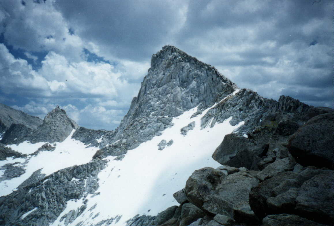
Secor says to take the class two ridge from the pass, which I did. I wouldn't exactly call it class two. Most of the way I was able to walk on sand, avoiding any rock at all. There is absolutely no talus to speak of on Sawtooth Peak, at least on the west side. This "class 2" ridge was actually vertical, or worse, on the east side, and on the west a very narrow ribbon of sand runs along the crest. If you move 100 feet more to the east the slope quickly steepens, and soon drops off dramtically into the cliffs that rise above Monarch Lakes. Were it not for the sand, this ridge would be difficult class 3 at the least. Amazingly I walked unscathed through the towering blocks that were rising all around me, taking care to stay below the jagged blocks higher up the ridge, but above the cliffs below. In only 30 minutes I was almost at the top, and the views of the massive Kern Plateau were now becoming more impressive. About 150 feet from the top, the sand disappears and all that is left is rock. The rock of the ridge crest was easilly class three, so I moved east to the spine of the peak where the rock looked smaller. Here it was easy pickings but the rocks were still huge. 50 feet from the top, the rock became larger than life. I took off my external frame pack, loaded up my pockets with cameras, munchies and the required can of Hawaiian Punch and started climbing rock, taking notice of where I left my pack. It had taken me 30 minutes to hike the first 600 feet to the summit, and now it had taken me another 30 minutes for remaining 150 feet. I as absolutely horrified when I reached the summit to find that the highest rock on the peak was actually a giant fin that actually jutted out from the face. 1500 feet below this rock was Columbine Lake. I was actually looking DOWN on the lake from above. Since the blade was only 9 inches accross along the top, I gave up all hope of sitting on the highpoint and decided that I might be able to wedge myself in the crack on the east and safely touch the highpoint. After this feat had been accomplished, I started searching for the summit register in the cracks, which remained MIA after 45 minutes of hunting. While searching I noticed that the rock on the east side was MUCH better, perhaps even talus like. Needham actually looked easy from here although the 1,200 foot drop that would have to be done twice would have been murder. There was absolutely no sign that anyone had been up there in a long while, perhaps I was the first to summit this year?
Secor mentions the quality of the view, and on this point I agree with him. The Kaweahs stood out like a bunch of sore thumbs, as they always do. From my vantage point I could see them all, but I was close enough to see how big they really are. To the north east was the Whitney group, which was snow free. Far below me was the summit tower of Mineral Peak, and to the south I had an impressive view of Tulare Peak and the north face of Florence Peak. Far off in the distance was Olancha Peak and further south were Owens and Siretta, so far away they almost seemed like they were in a different mountain range. I would definately say that this view is one of the best in all of the Sierra.
I shot my pictures, drank my punch and started back down at 10:30, which was just by chance when I said I would call my mom when I got back to the trailhead. So I was a little late....
I found a quicker if not easier way down to my pack and then headed down more, aiming for what appeared to be smaller rock below. From here I set off on a level traverese back to the pass and quickly hit sand again. I neared the pass quickly, aiming for the little group of trees that hand't been ripped to shreds during the winter avalanches. Then all of the sudden everything went bad. I guess I had gone down slope too far. I now found myself climbing over sand covered ribs on extremely steep slopes. I aimed up slope but always seemed to be heading down, as the sand just flowed over the underlying rock. When I reached a large patch of sand I began climbing up the chute. A large chunk of wet sand then broke loose and I began sliding down the chute. As I slid down I worked my way over to the rib on the other side of the chute and stopped myself. It took almost an hour to climb the rock, and on numerous occasions I had to take off my pack and throw it onto the rocks above. Once my pack slid off and landed water bottle first which cracked the cap and sent water flying everywhere. This was most definately the most frightening experience I'd had while mountaineering, but it taught me to take the advice of guide books with a healthy dose of skepticism. When I made it back to the pass I noticed that there were other tracks headed towards the direction I had come from, but that they never appeared on the other side of the chutes. I was now two hours late, and still had over five miles to hike.
When I reached my campsite I found my tent had been blown down to the lake. Luckily it had gotten stuck on a boulder. I packed and was on the trail in 10 minutes. Although it only took 90 minutes to reach the trailhead , it seemed like eternity. When I got to my car, I found that there was a group of people staring at it. I then saw a woman walking around my car, looking underneath as she circled. Apparently, a family of Marmots had taken up residence in my engine compartment during the 20 hours I was gone. She was one of the owners of the cabin on the east side of the Sawtooth parking lot, and had seen them invade earlier that day. She asked about where I'd been. According to what she said, her grandfather placed the original summit register on Sawtooth Peak, but that it had been stolen a couple of years ago (wish I had known that on top!) We had a lengthy discussion about marmots and how they've only reecently become a problem to cars. Apparently her family had been putting out salt blocks each june since the '30s but the new superintendant of Sequoia/Kings Canyon asked them to stop "because it is unnatural" (like the parking lot and pay phone IS natural!). Only when they stopped putting out the salt blocks did the marmots start attacking cars. She said that next year (1997) the park would allow them to again put out salt licks, but only until the area salt brush grew. While standing there I witnessed marmots climbing under every single car in the parking lot, even the ones with the chicken wire contraptions. Her own truck was completely wrapped in chicken wire which was burried over a foot into the ground. As I made my way over to the natural phone booth I saw marmots under her truck.
When I called mom she told me that she had called the Park Service just 30 minutes ago because I hadn't called her. Yikes! If only my car phone had had a battery.... I then called the Park Service and informed them that I was out safely.
Halfway down the road I passed a truck and for some reason we both stopped and backed up in an even similar to the one on the previous day. (odd!) This was one of the people comming to rescue me. How strange this trip had been. The rescue guy (for lack of a better term) and I discussed my climb and mountaineering in Mineral King in general. Although I was the second person to try Sawtooth that year, I was the first to make it. He was absolutely amazed that I had made it up so early in the season. He said just the week before, someone had gotten caught in one of the sand chutes and had to be rescued. I answered back "Well, its best to stay up higher....."
Photos: