Lassen Peak
Revised 9 Apr 2012 - please send updates to the webmaster
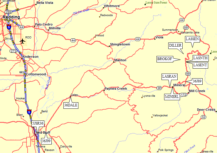
From I-5, exit in Red Bluff (waypoint 5JSR36) and go northeast and then east on Hwy 36. In both summer and winter, you should stop at the ranger station on the north side of Hwy 36 just west of the town of Mineral (waypoint LASRAN) for permits, which are self-issue in winter. At one time you could self-issue permits at the trailhead, but don't count on it.
Here is a road map from Red Bluff. Trail maps are below:

Follow SR36 northeast to Dales (waypoint 36DALE) where it turns east toward Mineral. About 41 miles from Red Bluff is the ranger station mentioned above (waypoint LASRAN), just before the town of Mineral. 4 miles beyond the ranger station turn north on Hwy 89 (waypoint 36J89) and continue 6 miles to the entrance station (waypoint LASENT), where you must pay $10 year round (use self-pay slot if the station is unmanned). If you have a Golden Eagle or similar pass, you can write the number on the envelope at the entrance station. You will be ticketed if you don't have an envelope stub on your dash. It's not clear if you can park along 89 just outside the entrance station to avoid the fee.
In the winter, the south approach to Lassen is closed at or before "The Chalet", which serves the overnight parking lot (waypoint LASNTH) next to the park entrance station. The chalet has pay phones, restrooms, and a first aid station, and appears to be mostly open year round even though the restaurant is closed in winter. The road is plowed to the parking loops between the entrance station and the chalet, which is within site of the entrance station.
| Jim Hasak reports in 2005: The chalet at Lassen Park was demolished last winter. This summer they set a portable building in the parking lot at the Mt. Lassen trailhead. It housed the gift shop and a reduced-service snack bar. The portable is now gone, presumably to be returned late in the spring. A new permanent structure is planned - I don't know the construction schedule. Meanwhile, there is still a restroom with running water near the parking lot, just beyond the ranger booth at the south entrance to the Park. |
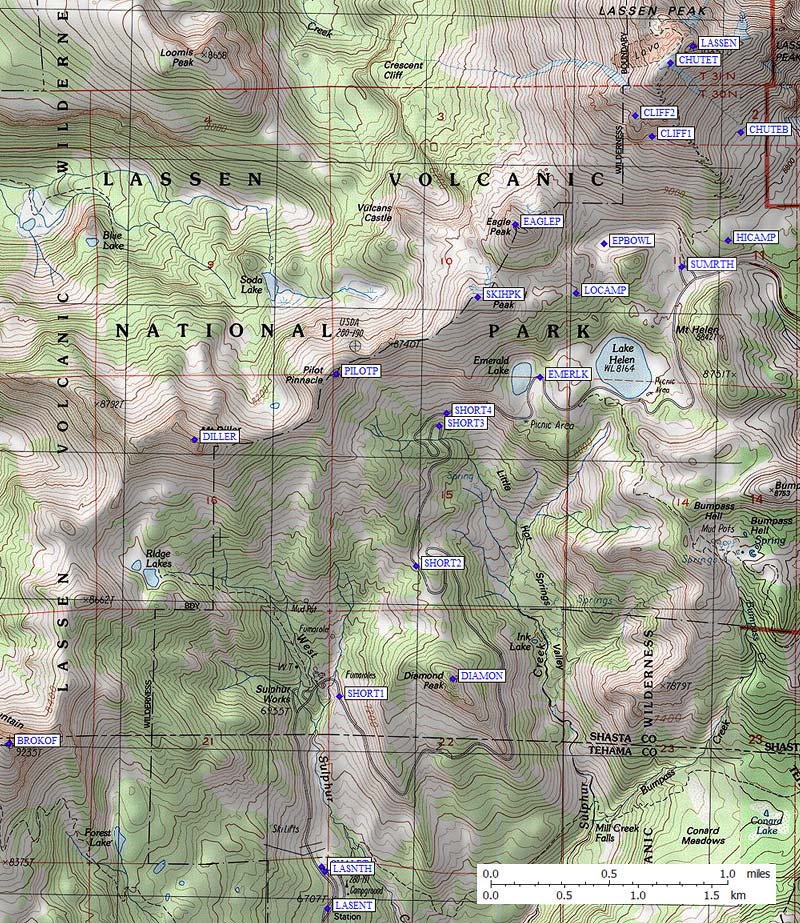
I parked at waypoint LASNTH, and followed the road over the bridge at the sulphur fumeroles, after which I cut cross-country SHORT1 to SHORT2 staying east and well above the stinky creek with loose muddy banks. One other obvious switchback shortcut is the exception to just following the road to Emerald Lake, where I went uphill and camped on a beautiful outcropping that looked down on Helen Lake from just east of Ski Heil (waypoint LOCAMP). From this campsite, you can climb both Ski Heil Peak (SKIHPK) and Eagle Peak (EAGLE) in an hour or two. On my second visit, we camped at waypoint HICAMP, which has great views of sunset and sunrise. Both campsites are well sheltered by trees. Diamond Peak (waypoint DIAMON) has the best view of Lassen, and is an obvious side trip if you're taking the shortcut from SHORT1 to SHORT2.
The snow chute between the cliffs southwest of Lassen Peak (EPBOWL, CLIFF1, CLIFF2) goes in winter, but beware of avalanche and rockfall danger. unless the snow is very stable. You can also run the ridge where the summer trail goes, or you can climb the bowl on the southeast face of Lassen Peak (not Mt Lassen!). The best glissade BY FAR is on the SE face, between waypoints CHUTET and CHUTEB, a wide open slope that tops out at about 35 degrees.

Useful Links: