Coldstream Valley
Revised Jan 2005 - please send updates to the webmaster
Additional maps are below with winter and summer directions.
Aaron_Schuman's summer description: GPS route DEERFIELD COLDSTREAM
(see also Steve Eckert's winter description with waypoints, below)
From Interstate 80, go south on Hwy 89 just east of Donner Summit. (This may be a mis-statement! If accurate, follow waypoints H89I80 and DEERDR to reach waypoint DREXIT: The connector from Hwy 89 is closed in winter. Leave Hwy 89 at the Deerfield Drive stoplight. Tucked out of sight are a grocery and drug store, pizza place, and a good chinese restaurant. Continuing west on Deerfield you'll find the road isn't plowed in winter and even though it's routinely travelled by snowmobiles or snowcats it's not packed solid enough for wheeled vehicles.)
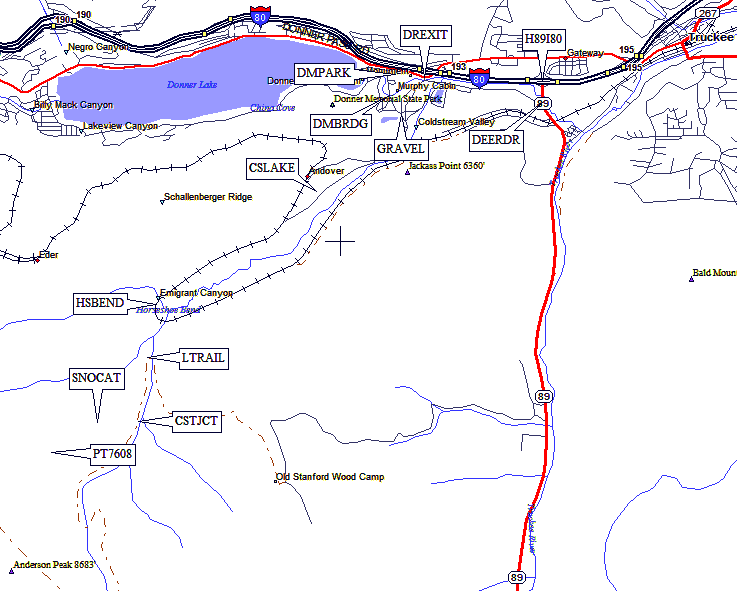
Access to Coldstream Valley starts with a drive through, or just adjacent to, Donner State Memorial Park.
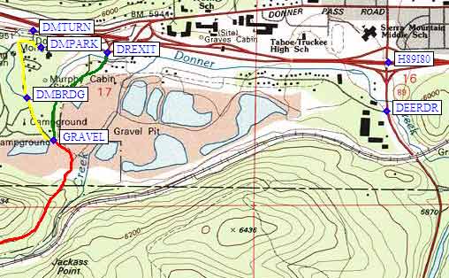
The trailhead is slightly different depending on the season. May to October, drive through the park proper (waypoint DMTURN), but November through April, the road through the park is gated, but there is an open-gated road just 1/4 mile east of the park entrance (waypoint DREXIT ??).
Follow the high quality graded dirt road until the well marked junction to Tinker Knob, then turn right on the rugged jeep track. Beyond the junction, the road might be too rough for ordinary passenger cars. After 1-1/2 miles, the road crosses a small stream, then a couple hundred yards later, it reaches the main watercourse, just inside Horseshoe Bend, a hairpin curve in the SP railroad tracks which is named on the Donner Pass quadrangle map. In the springtime, the second creek crossing is the end of the drivable road.
We parked there, at about 6300 feet (just down-canyon from waypoint HSBEND). We crossed Coldstream Creek up on the railroad tracks and began our cross country ascent.
Steve Eckert's winter description: (Jan 2005) GPS route DONNER COLDSTREAM
(see also Aaron Schuman's summer description, above)
Exit Hwy 80 at the Donner Pass Road exit (where a sign says "Donner State Park") and go south toward the filling stations and Holiday Inn. (The Chevron sells Krispy Kreme donuts, and is open 24 hours!) There's a stop sign at the road which goes west to Donner Lake (waypoint DREXIT), and a nearby sign that says turn right for a Sno-Park, but in fact there is no Sno-Park anywhere near here. Follow the sign and turn west anyway, then turn left (south) at the first driveway (waypoint DMTURN). If you start seeing houses, you've gone to far!
The sign may be covered by snow, but waypoint DMTURN is the Donner Memorial State Park entrance. You can park in the museum parking lot (waypoint DMPARK) at no charge and with no Sno-Park permit, as of 2005, but only during the day. There are no Sno-Park signs, and no signs regulating parking, but this info is based on what a museum volunteer told me. The museum closes at or before 4pm in winter, and there are no trailhead signs.
If you want to park overnight, you cannot use the Donner Memorial parking lot. You must risk parking on the street over by the Holiday Inn. From the exit at I-80, go south from waypoint DREXIT, between the filling stations, and park along the road near the Holiday Inn. You can't park in the Inn's lot, and you may be towed if plows are needed on the road, but that's what the locals told me they do. DO NOT try to drive up the road past the Holiday Inn. I saw half a dozen 4WDs stuck there all at the same time.
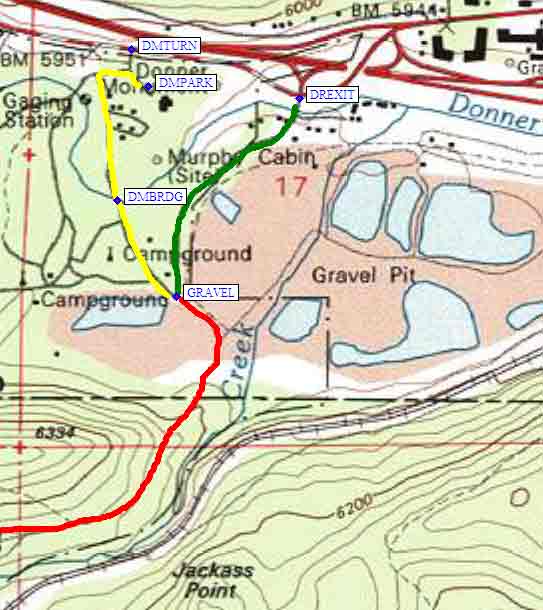
It's roughly the same walk from either parking spot. The road south from the Holiday Inn (the green line) is well packed by snowmobiles, and there are many branching use trails heading south from the Donner Memorial. If you park in the museum lot, you can walk down the off-limits road past residences (the yellow line), or you can go cross country directly south. If you park at the museum make sure you go via waypoint DMBRDG, a bridge across the stream that runs all winter. The routes from the two parking spots converge at waypoint GRAVEL, where the road through the Donner Memorial campground joins the road past the Holiday Inn. Cross the old gravel pit and head up the Cold Creek drainage (Coldstream Valley), passing below Jackass Point on your way to Horseshoe Bend (the red line).
There's a fork at waypoint CSLAKE, where the packed road stays on the west side of the drainage and ski tracks switch to the east side of the drainage. The road is technically off limits but since this is all private land, but they told me they don't mind ski and snowshoe visitors even though they didn't like motorized access.
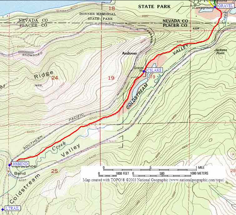
The road crosses the railroad tracks at waypoint HSBEND and starts to fork in various directions. These roads are kept open by snowmobiles and snowcats operated by (among others?) the Lost Trail Lodge. This lodge (at waypoint LTRAIL) is just up-canyon from Horseshoe Bend, and offers plush accommodations for $55/night/person. There are also snowcats that will take you on up the ridge for skiing and snowboarding.
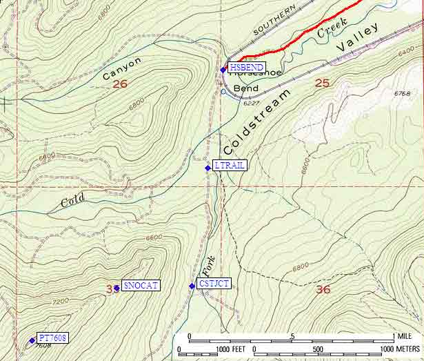
The USGS map shows a jeep trail going up the South Fork of Cold Creek, but in the winter the snowcat trail leaves that route somewhere upcanyon from waypoint CSTJCT (where there is a sign pointing south for Coldstream Trail) and switchbacks up the slope north west of that stream, leading you to the ridge (waypoint SNOCAT, where the snowcats turn around) northeast of Point 7608 (waypoint PT7608). From here you can follow the ridgeline south to to Anderson Peak, Tinker Knob, Silver Peak, Granite Chief, and Squaw Valley (which does not allow backcountry access), or you can head north to Mt Lincoln, Mt Judah, and the Sugarbowl ski lifts (which offer one-way Judah lift tickets specifically for access to the backcountry).
Useful Links: