Lee Canyon in the Spring Mountains
(Charleston, Mummy, and McFarland)
Revised 2 Apr 2025 - please send updates to the webmaster
The Spring Mountains are west of Las Vegas, and mostly encircled by Hwy 160 and Hwy 95. This page only has details of the Lee Canyon approach to the highest altitude cluster of DPS List peaks (Charleston, Mummy, McFarland). There are links above for the other three peaks (Stirling, Bridge, Potosi).
Here is a road map for all the Spring Mountains peaks. Below are details for Lee Canyon.
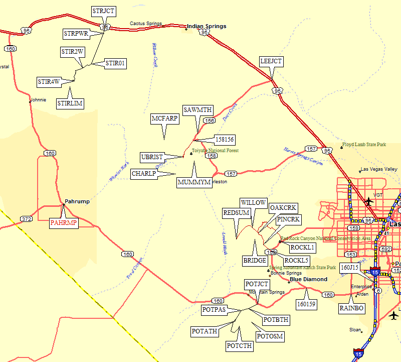
Roughly 30 miles northwest from downtown Las Vegas on Hwy 95, the turn up Lee Canyon is marked as both Hwy 156 and Lee Canyon. Hwy 156 is a nice wide paved road that climbs steadily to the west. 13 miles from Hwy 95 there is ample paved parking, picnic tables, and restrooms for the Sawmill Trailhead at around 7.5k (waypoint SAWMTH) near treeline. A sign saying no fires or charcoal from Apr 15 to Nov 15 indicates this campground is open all year.
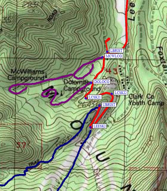
Continue straight on Hwy 156 past the junction with Hwy 158 (waypoint 158156, 14 miles from Hwy 95) to reach Lee Canyon and the ski area trailheads. There are also trailheads and camping on the other side of the mountain, which this file does not describe. (Additional info is welcome if you have been to the other side!) The Lower Bristlecone trailhead turnoff (waypoint LBRIST) is just under 17 miles from Hwy 95 and is immediately before the McWilliams Campground turnoff (waypoint MCWLCG), which is open all year.
|
I stayed at the Dolomite Campground (waypoint DOLOCG), which closes for the
winter in October. It's a quarter mile further up but seemed to have more
space between the campsites. It's astonishingly expensive ($19/night in 2009)
for what you get (cold water and a flush toilet), and it's astonishingly
noisy since locals come up just to party for the night. Some people wisely
stayed in their vehicles at the Upper Bristlecone trailhead instead.
Continuing past the campgrounds, Hwy 156 does a sharp S-turn as it climbs to a hairpin turn by the Las Vegas Ski and Snowboard Resort (aka 'the ski area', at waypoint LEESKI). From this hairpin to the end of the road (waypoint UBRIST) is all parking for the Upper Bristlecone Trailhead at 8.7k. To access the ski lift route to Charleston and Mummy in summer, walk from wherever you park to the hairpin (waypoint LEESKI), go through the ski area's gate and continue southwest between the buildings, then keep right on the grassy slopes until you see the ski lift. It feels a bit like trespassing, but lots of people hike here so it must be OK. Find the gravel maintenance road that goes up under the ski lifts or just walk on the rocky grass. For the Bristlecone trail to McFarland, go to the end of the road (waypoint UBRIST) and follow the fenced trail southwest into a drainage. Mike McDermitt adds: The Lower Bristlecone trail starts at LBRIST, there is trailhead parking. Walk up the trail which goes up Scounts Canyon - as the maps shows, it is forest service dirt road - about a mile to a hairpin turn. At that point the map shows a road going SW to a dead end -- this is a mere trail now but follow it then continue on drainage to hikers right. There is a trail rather faint but it takes you up to the ridge and trail about halfway between PT3041 and MCFAR1. Much shorter if headed to McFarland. |
|
Useful Links: