Joshua Tree Trailheads
(Eagle Mtn South, Pinto Mtn, Spectre Pt)
(nearby Orocopia Mtn, Sheephole Mtn)
Revised Jan 2012 - please send updates to the webmaster
Halfway between Indio and Desert Center on I-10 (23 miles from each of them), exit at Cottonwood Springs Rd, the turnoff for Joshua Tree National Monument (waypoint COTJ10). This is the first exit west of Chiriaco Summit. For Orocopia, go south toward Mecca. For Eagle and Pinto, go north into Joshua Tree. (Continuing north will take you to Hwy 62 near Twentynine Palms, 45 miles from I-10.)
If you're driving here from Northern CA, consider routing through Tehachapi Pass and Mojave on Hwy 58, down Hwy 395 to Adelanto and Victorville, then Hwy 18 through Apple Valley and on to Yucca Valley on Hwy 247, then to Twentynine Palms and Joshua Tree on Hwy 62 instead of dealing with LA traffic and the variability of I-10.
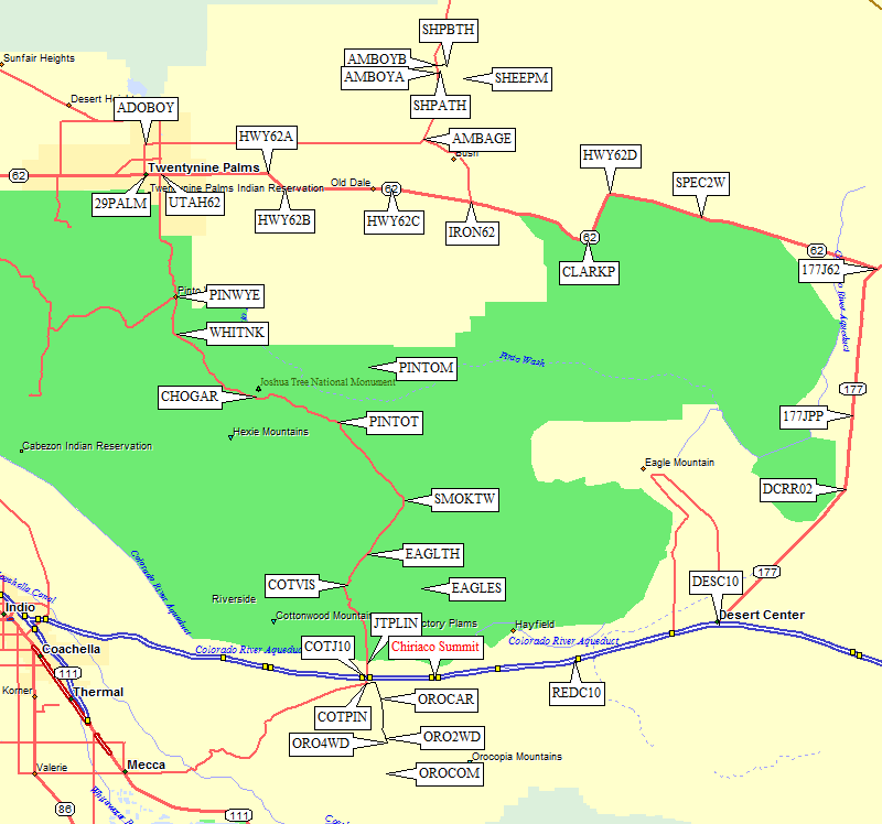
Overview Map, see details for
Orocopia Mtn,
Eagle Mtn,
Pinto Mtn,
Sheephole Mtn,
Spectre Pt
below:
Halfway between Indio and Desert Center on I-10 (23 miles from each of them),
exit at Cottonwood Springs Rd, the turnoff for Joshua Tree National Monument
(waypoint COTJ10). Go 0.4 miles south, toward Mecca rather than into Joshua Tree,
on a good paved road. Where the road bends right (west) and becomes Box Canyon Rd,
turn left (east) on Pinto Rd (waypoint COTPIN). There is a parking area on the right
just beyond this turn, which is a great place to meet people but might not be a
safe place to leave cars.
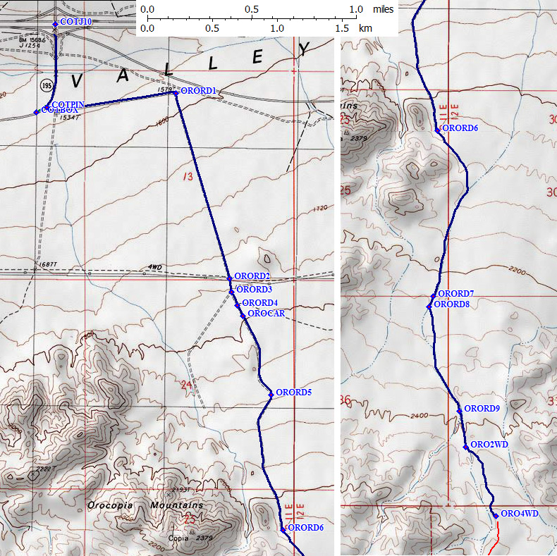
Turn left (waypoint COTPIN) and parallel freeway to the east on Pinto Road.
It is paved, but sand has washed across it in many places. Go east until you can
see a 30mph right turn sign, then turn right BEFORE the sign (1 mile from the freeway)
onto an unmarked dirt road which goes uphill to the south (waypoint ORORD1).
This road is fine for all passenger cars here, but gets worse beyond the power lines.
2 miles from the freeway you will cross under high voltage power lines (waypoint ORORD2).
Go straight across powerline access road, and 100 yards later take a left fork where
main road curves right (waypoint ORORD3). Ignore a left turn between here and the
passenger car parking area (waypoint ORORD4).
Orocopia Driving Details - right map section is southern continuation of left section: (see overview map above)
2.1 miles from the freeway is a flat spot where passenger cars might want to stop
(waypoint OROCAR). It's flat enough to camp but still within sight of the freeway.
I drove a passenger car to waypoint ORO2WD in March 2010, scouting after some heavy
rain had settled the sand. In late May, when I went back with a 4WD and climbed the peak,
the road was far more deeply rutted and the sand was much softer. I don't think I could
have driven as far with the road like it was in May, which I presume will be even worse
in the fall after more traffic.
The best roads consistently go to the right, this route keeps left at each turn after OROCAR.
There was an unexpected junction 4.1 miles from the freeway (waypoint ORORD7),
which I don't think is in the DPS Guide. Turn left, then immediately take a left fork
(waypoint ORORD8). Keep left again at the next fork (waypoint ORORD9), 4.7 miles from
the freeway.
The 2WD trailhead is a fork in the canyon, not a fork in the road, 4.9 miles from
the freeway at 2400' (waypoint ORO2WD). I turned my passenger car around here in March.
Follow the road another 50 yards to the steep left-side climb out of the wash.
All-wheel-drive and non-locking 4WD vehicles were seen spinning on the next short but
steep and bumpy section. That climb is the only place you need 4WD unless the sand gets too soft.
The 4WD trailhead is 5.2 miles from the freeway, at 2500' (waypoint ORO4WD) where
wilderness stakes and a turnaround loop mark the current end of the road.
There isn't much extra walking from the 2WD trailhead, so don't worry if you
can't get up that one steep bit!
For details of climbing Orocopia, see my 2010 trip report.
Orocopia Mountain - GPS Routes INTERSTATE 10 and OROCOPIA MTN
Eagle Mountain South - GPS Routes JOSHUA TREE and EAGLE MTN S
|
Halfway between Indio and Desert Center on I-10 (23 miles from each of them),
exit at Cottonwood Springs Rd, the turnoff for Joshua Tree National Monument
(waypoint COTJ10). Go north into Joshua Tree, on a good paved road.
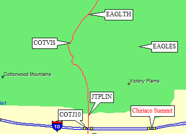
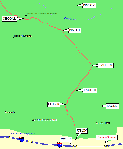
Before you enter Joshua Tree, about a mile from the freeway, you will cross a high voltage powerline and the Colorado River Canal. There are several dirt roads which could be powerline access but which serve as free and unrestricted camping areas (near waypoint JTPLIN). Motor homes spread out their stuff here, in level parking areas along the roads, and it's a good backup if the campgrounds are full. Inside Joshua Tree, you must pay an entrance fee. It's unclear what can happen if you don't pay, but the DPS Guide indicates towing and fines are possible. The Cottonwood Visitor Center (waypoint COTVIS, 6.8 miles from the freeway) opens at 8am, and if you arrive earlier there was no way to self-pay as of 2010. |
You can park at the Visitor Center or camp in the nearby Cottonwood campground, and approach Eagle that way, but these directions send you to a more remote trailhead where you won't have to deal with the crowds.
9.3 miles from I-10 there is a small pull-out (waypoint EAGLTH at 3.1k) that used to be a dirt road to the Borrow Pit shown on the USGS map (now a seasonal pond). (This pull-out is about 35 miles from Hwy 62 near Twentynine Palms, if you're coming from the north.) There is no sign or marker for this turn, which is narrow enough to miss it and only a few car lengths from the pavement it is blocked by boulders. You could probably squeeze in 4 cars, and I'm not sure if it's OK to park along the highway. Walk a straight line to the mouth of the canyon leading to Eagle.
For details of climbing Eagle, see my 2010 trip report.
Pinto Mountain - GPS Routes JOSHUA TREE and PINTO MTN
|
Halfway between Indio and Desert Center on I-10 (23 miles from each of them),
exit at Cottonwood Springs Rd, the turnoff for Joshua Tree National Monument
(waypoint COTJ10). Go north into Joshua Tree, on a good paved road.
Before you enter Joshua Tree, about a mile from the freeway, you will cross a high voltage powerline and the Colorado River Canal. There are several dirt roads which could be powerline access but which serve as free and unrestricted camping areas (near waypoint JTPLIN). Motor homes spread out their stuff here, in level parking areas along the roads, and it's a good backup if the campgrounds are full. Inside Joshua Tree, you must pay an entrance fee. It's unclear what can happen if you don't pay, but the DPS Guide indicates towing and fines are possible. The Cottonwood Visitor Center (waypoint COTVIS, 6.8 miles from the freeway) opens at 8am, and if you arrive earlier there was no way to self-pay as of 2010. |
Continue north, past the visitor center (waypoint COTVIS) and the trailhead for Eagle (waypoint EAGLTH). 20.5 miles from I-10, about 11 miles north of the Eagle trailhead, you should easily see the Turkey Flats informative exhibit sign in the large trailhead parking area (waypoint PNTOTH at 1.8k). (This pull-out is about 24 miles from Hwy 62 near Twentynine Palms, if you're coming from the north.) There is a wilderness registration board here, where you should sign in if you plan to be out overnight. (The DPS Guide says everyone should register, but the rangers told me in 2010 that it's only for overnight travel.) Walk a straight line to the base of the summit ridge leading to Pinto.
If you've come this far, you should really go on to the Cholla Cactus Garden (waypoint CHOGAR) to see one of the tallest stands of Cholla anywhere. It's a short loop with interpretive stops.
For details of climbing Pinto, see my 2010 trip report.
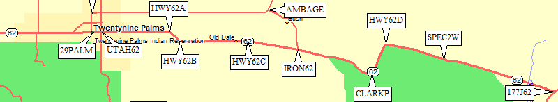
Most people will drive through Twentynine Palms on their way to Sheephole,
but if you're coming from the east on Hwy 62 you can bypass the town by
leaving Hwy 62 at Iron Age Road (waypoint IRON62), and following this dirt
road 5.8 miles nothwest to the big bend in Amboy Road (waypoint AMBAGE).
Iron Age Road may have a bit of mud after a storm, but it's suitable for
all vehicles.
Starting in the small town of Twentynine Palms, the northern gateway to Joshua Tree,
go north on Adobe Road (waypoint 29PALM) for two miles, then turn right (east)
on Amboy Road (waypoint ADOBOY). Follow this increasingly rural road 18.3 miles due east,
where it turns north at Iron Age Road (waypoint AMBAGE) and climbs 5 miles to Sheep Hole Pass.
(Don't ask. I don't know!) As mentioned above, Iron Age Road can be used to bypass
Twentynine Palms if you're doing both Sheephole and Spectre.
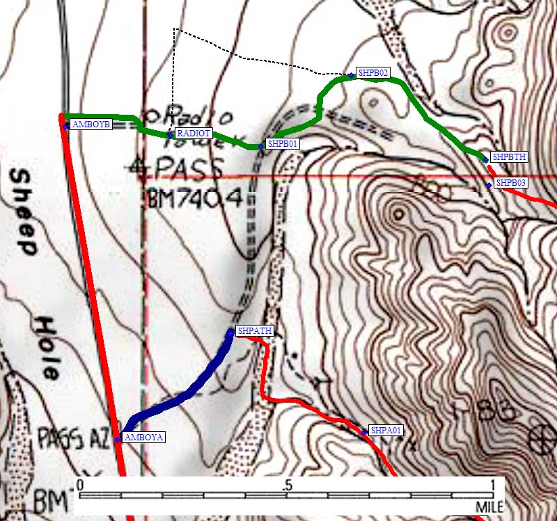
Route A:
Half a mile south of the actual pass, there is an unmarked dirt road
(waypoint AMBOYA at 2.3k) which leads a quarter mile notheast to the
DPS Guide's Route A trailhead (waypoint SHPATH at 2.4k). This is the
blue line on the map,
Route B:
At the high point of Amboy Road (waypoint AMBOYB at 2.4k) there is a
power line which crosses to a radio tower, and another dirt road
follows this power line to that tower on the way to Route B. I found
the DPS Guide's directions (black dashed line) worked, but were not the
best driving. Follow the powerline to the radio tower, then take the
track looping around to the right (south) behind the tower (the green
line on the map is an actual GPS track log). Stay close to tower as you
go around it (waypoint RADIOT, less than 0.2 miles from the pavement),
but continue uphill (east) to a road that probably connects to SHPATH.
Bear left (northeast) on this road (waypoint SHPB01, a third of a mile
from the pavement) and follow the left bank of a wash for a short
distance before pulling away on the far side of a small shoulder.
The road bends east and the DPS road (narrow and sandy) comes in
from the left as you go behind a bump (waypoint SHPB02, half a mile
from the pavement). Shortly after that intersection you go past
the concrete water collector mentioned in DPS Guide.
The road goes further than the DPS Guide indicates, and my waypoint
is at the end of road (SHPBTH at 2.6k, 0.8 miles from the pavement).
There is a small place to turn around, but only enough room for a
few vehicles to park. If this area is full, go back a tenth of a
mile to the DPS trailhead on the shoulder.
For details of climbing Sheephole, see my 2010 trip report.
Most people will drive through Twentynine Palms (waypoint 29PALM) and
Clarks Pass (waypoint CLARKP) on their way to Spectre. You can also
approach from the east on Hwy 62 from Rice or Desert Center
(waypoint DESC10). The trailhead (waypoint SPEC2W) is 40 miles east
of Twentynine Palms (waypoint 29PALM) and 12 miles west of where
Hwy 177 intersects Hwy 62 (waypoint 177J62).
Follow your GPS to SPEC2W or find the old dirt road by looking for a place
where the highway goes through a depression in an otherwise mostly flat area.
The trailhead road is the stream that forms that depression, climbing slowly
south from the pavement. Sand washed over the old road is erasing the roadbed,
and when you first leave the parking area it's difficult to be sure you're
actually on a road.
The Spectre trailhead road is now closed, fenced, and gated only 100' from
the pavement. There's no reason to drive the last few yards, just park on the
side of the paved highway (waypoint SPEC2W at 1.7k) to avoid very soft sand.
Since you can't get very far off the highway, the trailhead is a bad place
to spend the night. 4 miles east of the trailhead (8 miles from Hwy 177)
there is a dirt road leading north, where I spent a very quiet night about
a mile off the pavement in 2010.
For details of climbing Spectre, see my 2010 trip report.
Useful Links:
Sheephole Mountain - GPS Routes TWENTYNINE PALMS and SHEEPHOLE MTN
Spectre Point - GPS Routes TWENTYNINE PALMS and SPECTRE POINT