Baboquivari Peak
Revised May 2008 - please send updates to the webmaster
If you're coming from Phoenix, take I-10 east just past the intersection with I-8 near Casa Grande. Go south on IR15 (all on Indian Reservation land with very few services), then southeast on Hwy 86. If you are also climbing Ajo or Kino, that's the other way on Hwy 86. If you're coming from Tucson, just go west on Hwy 86 and plan to spend at least half a day at the Arizona-Sonora Desert Museum (and zoo) as you drive past it - well worth your time!
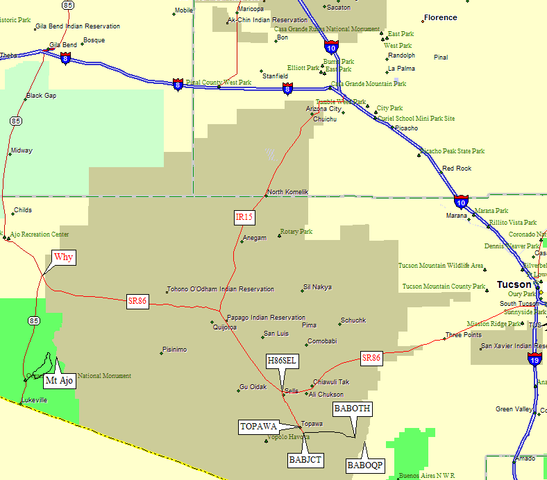
Either way, get yourself to the town of Sells and turn south on IR19 (at waypoint H86SEL). The DPS Guide mentions a Chevron station, which I don't think is there anymore. There was major road construction in 2008, the road we turned on didn't seem to have a marked name, but you're headed for Topawa. Turn right at the sign for Topawa / San Miguel (waypoint TOPJCT) and head south out of Sells, at which point you should see highway signs labelled "Indian 19". Topawa has a faded City Center sign (waypoint TOPAWA), but we didn't see much in the way of services.
Just south of Topawa, about 10 miles south of Hwy 86, turn left onto a dirt road at the Baboquivari Park sign (waypoint BABJCT). This wooden sign doesn't have an arrow and could be mistakenly interpreted as inviting you to go straight. The dirt road is fine for all vehicles. The only real junction between the pavement and the trailhead is at waypoint BABDR3, where you keep right (go straight) as the sign suggests. Beyond this the road deteriorates considerably, but is still quite passable for passenger cars. Near the trailhead a road comes in from the right - this isn't a junction you'll consider on the way in, but don't get confused here on the way out!
You need to contact the Baboquivari District Office at 520-383-2366 before using the campground at the end of this road, but there doesn't seem to be a fee and there may or may not be a caretaker there. We found the campground totally full even though we had a reservation (a large group of locals was having a cultural event), but we found a primitive site to camp near the steel water tank mentioned in the climbing instructions.
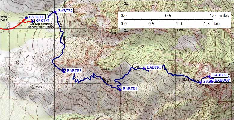
The campground and normal trailhead is at waypoint BABOTH, the steel water tank is at waypoint BABTR1. Start either place and follow the wide well-maintained trail east to waypoint BABTR2, where it turns south and traverses around the end of the ridge. The trail traverses the south side of the ridge almost to the saddle east of Point 5925, then follows the ridge east through a cooler pine forest toward the peak. Campsites and fire rings are near waypoint BABTR5. Above this there's a lot of shade, so temps will be cooler than you might expect.
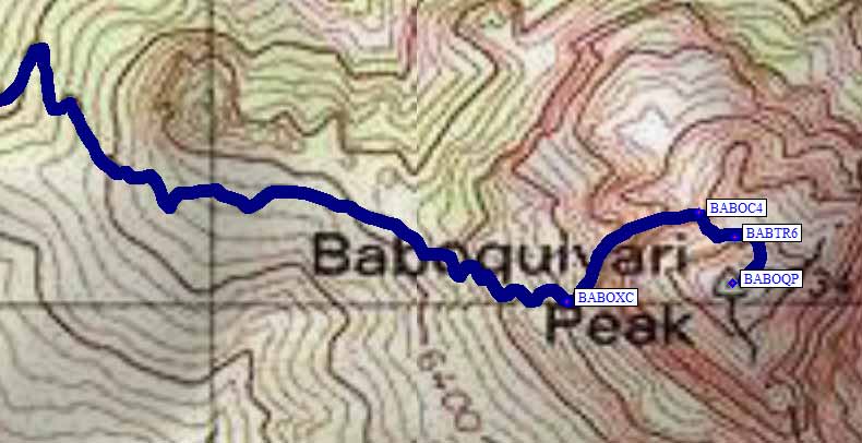
The trail slowly turns into a rough use trail, which we followed to waypoint BABOXC. Here we went left across a talus slope to a left-ascending ledge. You'll know you're in the right place if you see scraps of lumber and wire which used to be a ladder over the hard part of the climb. Ascend the class 2-3 ledge next to the huge cliff on your right, ending up at the base of the 4th class wall (waypoint BABOC4). Look for old steel ladder supports sticking out of the wall for where to climb, but clip into the bolted hangers you'll find about 20' up in the center of the chute (contrary to what the DPS guide says). You can climb and rap this 800-100 ft section with a single 60m rope (contrary to what the DPS guide says), and you can rap off an oak tree or you can spare the tree's bark and rap off a heavy steel chain bolted to the rock right by the tree. This technical pitch gets very little sun, so early or late season climbers may find ice on it. Climb up and go right around a corner before turning left and scrambling around a chockstone. From here to the top is a class 2 spiral that ascends the northeast side of the peak. Take note of your ascent route, as you'll need to find the use trail back down to the chockstone.
Useful Links: