Such was the case this past week when Bob Davey, Ron Eckelmann and I ventured into the high country of Glacier Divide in the Bishop Creek drainage. Among the dazzling summits, deep blue lakes, ice scoured slabs, babbling streams and flourishing meadows, we found the peace that only comes with being in the wilderness with friends. I also found myself able to deal with an odd sadness. I felt a kind of melancholy driven by knowing that the Sierra of my youth is changing before my eyes. The glaciers, snow filled gullies and permanent expanses of snow found high on its upper slopes are disappearing, or are already gone. The great ice filled chutes on dozens of north faces have melted into obscurity. Climbing routes that I once had on my theoretical "hit list" no longer exist. Guidebooks and directions which describe approaches over snowfields and glaciers will be updated, ice and snow filled gullies have been replaced by loose and treacherous rock chutes. Some of these chutes are now shedding car size boulders that perhaps have not seen daylight for many hundreds of years.
Gravity and climate are mountain killers. Over eons of time, tectonics, erosion, great storms, relentless cycles of freezing and thawing, times of cold, times of heat, moving ice and shifting land, all take their toll. However, as these landscapes we grew to love change, new ones will be born. Hundreds of generations into the future, people just like those in our group will come to places like this and feel a jubilation similar to the one we experience when we enter this place of natural wonder. It will be a different, but it will still be amazing.
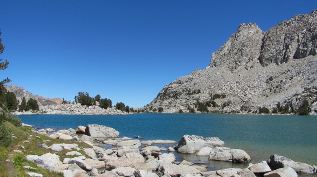
We departed from the Lake Sabrina trail-head on Saturday morning at 9:20. We planned a mild and relaxed first day, intending to camp near Baboon Lakes. We stuck with our plan and trekked south and up; up to the serenity of a basin filled with melted snow, crisp air and lively trout. We stopped along the way at Blue Lake for a lunch break and a chance to remove our boots for a bit.
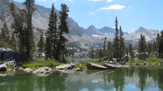
Blue Lake
The terrain above Blue Lake, heading towards Baboon and Sunset lakes is a twisted and convoluted land of tiny streams, meandering watersheds, rounded domes of granite, stunted forests and confusing use trails. For those heading towards Sunset Lake and the high spaces beyond, a bit of advice. Follow the well maintained trail in the direction of Donkey Lake. However, be ever conscious that Donkey Lake is not your destination. You will come to an intersection where a sign directs you left to Donkey Lake and another trail leading right and up. The sign does not indicate to where the right hand branch leads. Topographic maps show both trails ending near this junction. If you, as we did, follow the trail toward Donkey Lake, you'll soon be trying to pick your way south, wandering from duck to duck, from slab to slab, from one use trail to another. We spent a fair amount of effort and time before we eventually found a "real" use trail that led us up a drainage which ultimately followed a ramp that climbs to a low point in the ridge just north of Baboon Lakes. After a slight descent, we found a large platform of sandy spots where we could all spread out for our first camp. Given jet lag, a big objective for the next day and general weariness, we retired early.
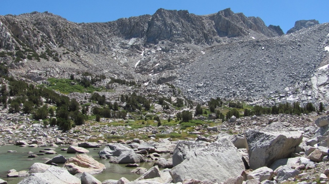
Baboon Lakes
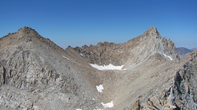
Sunday morning, Bob and I left our camp at 06:50 and headed for Thompson-Powell Col. Given the lack of snow, the challenge was substantial. We followed the land bridge which separates the two Baboon Lakes and worked toward the southern edge of the more eastern lake. From here we traversed east and south over a ridge into a meadow. Turning south, this meadow becomes a grassy slope leading to an obvious ramp and bench, above and west of Sunset Lake. At the end of the bench you'll find a reliable (for now?) stream. The lack of snow and ice was striking.
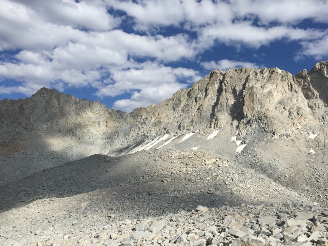
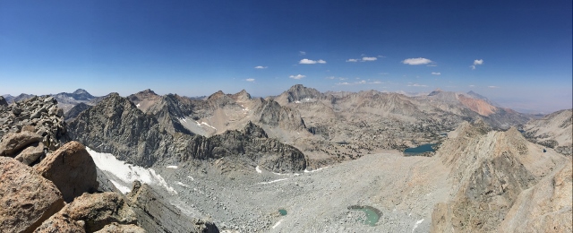
Thompson Glacier
The stream crossing marks where you can climb onto a long and prominent ridge of steep slabs heading up and toward the south-west. Climbing this rib avoids endless talus and brings you high enough to traverse and then climb toward the higher of the two saddles, the one known as Thompson-Powell Col. The col was snow free and pretty miserable. The steepest section was near what looks like an hourglass right in the middle. The chute was filled with loose rock on top of hard, well packed, conglomeration of dirt, sand and stones. This part of the climb was as stressful as it was aggravating. Working over to the right side of the chute brought easier climbing and we soon gained the sandy col.
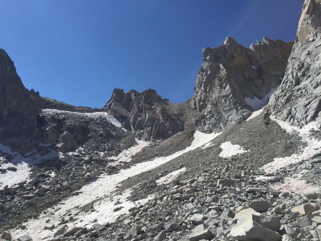
Thompson-Powell Col
We followed what Secor calls the Eckert Variation to climb Point Powell. From the col the climb is easy. We were on the summit before 1:30 PM. My original plan was to try Thompson on the same day, but I couldn't make the clock math work. I scrapped the idea and we headed back to camp. Our down-climb was only marginally faster and we arrived back in camp just around 7:00 PM.
Ron had spent the day fishing with good success, and we agreed that the next day we'd move over to Moonlight Lake by the normal circuitous collection of trails. We left mid-morning and were able to easily follow the use trail back to Blue Lake. The route was far more obvious than on the way up. We made it a leisurely day, stopping for lunch at Blue Lake. As afternoon marched on, we passed by the notable landmarks of Dingleberry, and Sailor Lakes. At eighty-one, I was impressed by Ron's stamina and relative speed as he moved under the weight of a pack loaded with a week's supplies. It was great Ron was able to join the trip and for us to spend time with someone who has such deep experience in these mountains.
The best route we could find to Moonlight Lake was as follows: Just above Sailor Lake you'll come to an intersection with a sign marking the direction of Hungry Packer Lake up to the right. Take a left at this junction on to an obvious, well-worn use trail. This trail crosses a stream right near the junction and then heads to the north-east shore of Hungry Packer Lake. Only some eighty yards after the stream crossing, you'll see a large cairn on the slabs to your left. Leave the use trail at this point and wander up the slabs, working up and left along easy ledges and benches. At the upper far left of the slabs, you'll see where some talus meets those slabs. Work through this talus for only fifty yards or so, then work down a faint path that leads through a campsite and finally to a path that follows the west shore of Moonlight Lake.
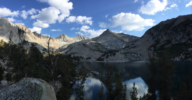
Moonlight Lake
We camped in the trees beside the meadow at the south end of the lake. This is one of the most stunning and picturesque places I've seen in the Sierra. A tranquil, blue lake, milky blue glacial streams, green grass, wild flowers, tree sheltered campsites, all nestled in a walled basin of steep granite faces and glacial moraines. Truly a paradise in paradise. This Shangri-La became our home for the next three nights. No matter if you visit to fish, practice photography, stage summit climbs or simply sit and gaze in wonder, I can't recommend this place enough. If you ever have the opportunity to visit the meadows above Moonlight Lake, you will be moved at the majesty and beauty of this spot of natural perfection.
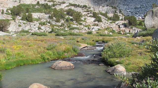
Moonlight Meadow
Tuesday I went out alone. My objective was to climb Picture Peak. Not expecting a long day, I left camp at 7:35. The day started off cool and breezy. I followed the right side of the stream issuing from Echo lake. Before nearing the lake, I climbed toward a bench and then a shoulder, high above the lake's north side. Picking my way over small talus, I found the middle chute of the south-west face with ease. The climbing in the chute was stable, with little loose rock. About midway up the chute you start to encounter short bits of third class. The chute ends in a large bowl just below the summit. Exiting the chute and heading up to the right, there are numerous third class options that lead to the summit, which is a slanted monolith of granite slab.
I summited at 10:40 and had wonderful views in all directions. I took pictures and started looking at the routes on Wallace and Haeckel. The climb down was quick and uneventful and I was back in camp around 1:30. I enjoyed a lazy nap and then spent the late afternoon golden hours taking pictures and enjoying various spots in the meadows. Later, during and after dinner, the three of us sat on a little perch above Moonlight lake, chatting and gazing until it was near dark.
Bob and I planned to climb both Haeckel and Wallace on Wednesday. The acoustic sounds of the introduction to Pearl Jam's "Off He Goes" coming from my iPhone alarm woke me at 4:45. The sky was still dark and speckled with the stars of a crisp pre-dawn. Coffee, warm clothes, a bit of food, and a final gear check led to our 6:20 departure. We basically retraced my steps from the previous day, only being careful to not climb too high on to the shoulder of Picture Peak. We managed a contoured traverse that joined with the stream coming out of Wallace-Haeckel Basin. We picked our way up slabs and benches before being forced on to small talus. Choosing to climb Haeckel first, we paused above the tarn that occupies the bowl of the upper basin. The wind was cold enough for extra layers of clothes and just a short break. Rather than climb to the col and follow the ridge to the summit, we angled up to the right, crossing under blocky, huge, fang like, gray talus. The route was awkward for this first bit, then became more fun as we followed ledges and easy third class up to the giant summit rocks. The final move to the summit requires an awkward squeeze up a wedge-like corner. Around the corner, up another block and it's over. Great mountain. Fun ridge climb. We were shocked to find that someone had placed three or four Vegas style "Private Dancer Stripper Cards" in the summit register. Pretty random thing to leave in a register can, but it gave us a good laugh.
Wallace and Haeckel
On the down climb we stayed closer to the ridge, following it all the way to the col. This was a more enjoyable route than our ascent. After resting at the col for a bit, we started up Mt. Wallace. After climbing second and a bit of third class for about half an hour, we came to the last thirty feet of climbing leading to the summit. We also marked this as third class, but sometimes these things can be subjective. The summit block required an interesting mantel as well. The scramble down the scree on Wallace's north side was a bit nerve wracking, but with plenty of daylight left we managed without undue complaint.
The trip back to our Moonlight Lake camp was uneventful, if not a tad slow. In the end we arrived back in camp right at 7:00 PM. Not another twelve-hour day, but close. We ended the day on our lakeside perch enjoying the sunset, crisp air and conversation.
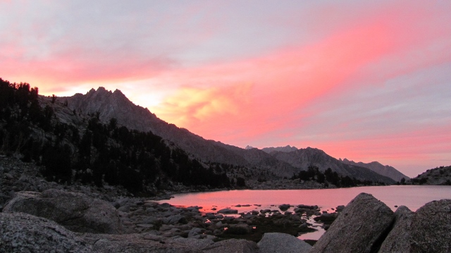
Sunset on Moonlight Lake
The more I see of the Sierra the more I'm curious about individual land features. For people who have spent a lot of time in these mountains, they have certainly seen something called a "rock glacier". However, they may not have even realized that's what they were looking at. According to the glaciology literature, a rock glacier has the appearance of a glacier of ice, however it appears to be made entirely of rocky debris and sand. These rock glaciers also move downhill, much as an ice glacier does, albeit much slower. It is broadly accepted many of these rock glaciers have cores of ice. The numerous rock glaciers in the Sierra are remnants of glaciers that formed during a period called the Matthes glacial advance. This advance is widely considered to have started roughly seven-hundred years ago. Any remaining ice glaciers in the Sierra were also formed during this same Matthes advance.
Powell Rock Glacier
When entering the Moonlight Lake basin, I saw a land feature that made no sense to me whatsoever. I had mistakenly remembered that prior to the Matthes(Little Ice Age) glacial advance, the Sierra had been devoid of glaciers from the end of the Tioga glacial advance which began roughly 26,000 years ago and ended some 15,000 years ago. Lasting about 11,000 years and creating great, deep "U" shaped valleys and obvious lateral and terminal moraines, the Tioga glacial advance acted like an eraser, removing trees, rock and everything else in its path. These features of the Tioga advance are visible all over the Sierra. In many cases, these features are many miles and thousands of feet below the high-country where the individual branches of those glaciers formed.
My confusion at Moonlight basin was based on seeing what appeared to be a glacial moraine located about five hundred feet lower and half a mile downhill from the massive Matthes era rock glacier, issuing forth from the nearly extinct Powell Glacier.
Matthes Era Terminal Moraine of Powell Rock Glacier, Above Moonlight Lake
Was I reading it wrong? Was it some form of major rock fall incident? In both cases, I'm inclined to say no. I could see no sources for such a rock-fall event. How could this moraine be present in a basin that had been swept clean by the Tioga glacial advance and yet be so far downhill from the obvious terminus of the Matthes event?
When I got home I hit the books. I had either missed or forgotten about the Recess Peak glacial advance. After the Tioga glaciers had disappeared, there appears to be a three-thousand-year period when the Sierra were likely ice free. Then, starting around twelve thousand, five hundred years ago there was a glacial advance that was marginally greater than the Matthes event, but nowhere near the size and scope of the Tioga advance. This is now known as the Recess Peak advance. I checked the maps, I read two science papers and now I'm fairly sure I have my culprit. The moraine at the outlet of Moonlight Lake, very well could be one of the many remnants of this bit of Sierra glacial history. Recess Peak. The little glacial advance that still leaves its mark on the places we love.
And with that I've come full circle. Like all of geology, the Sierra is subject to changes from time, climate and tectonic forces. We realize that the earth and its natural processes are always on the move. We need to move with them. When the mountains don't give you ice, climb rock.
Thursday morning, we slept in, casually packed our things, and as Bob said, "we're off at the crack of noon." We said good bye to our Moonlight Lake paradise and headed for the lowlands. Ron decided to stay for one more night and fish Hungry Packer Lake. Word is he had a wonderful last day. The three of us said our goodbyes where our trails diverged. Bob and I made our way down to Bishop, Ron went fishing for another day. Hopefully those trails which diverged will cross again and the three of us will enjoy more time together in the beautiful Sierra.