I've long been curious what the west face of Glacier Ridge looks like in snow, wondering if it would make a good snow climb. 3000' of fairly uniform steep west-facing slopes that no one even seems to consider. Combining those two curiosities into a last-minute trip before a big storm seemed like a good idea. I didn't even try to recruit anyone because I really didn't know if I'd attempt Glacier Ridge or just do Alta. I filed a "flight plan" with Stella and took my sat phone to keep her updated on where I was.
I packed on Friday morning, drove to Lodgepole and got a self-issue permit, parked at Wolverton (waypoint WOLVEP) and hiked in for an hour or two to start my acclimatization. The Lodgepole rangers said there was no bear activity, but there was fresh scat on the trail all the way to Heather Lake. The snow was really icy and I didn't put on snowshoes until the Panther/Pear trail junction at about 7.8k. By the way, the winter junction at waypoint PEAR03 is close to half a mile NW of the trail junction shown on the USGS map. From here the winter route (marked by widely dispersed tracks and yellow tags on trees) goes basically due west, crossing the Watchtower trail (closed in winter due to icy steep side-slopes down into Tokopah Valley) to re-join the summer trail to Pear Lake at around 8.5k. I camped near waypoint PEAR04, where the terrain levels out abruptly, with a great view of the sunset behind city lights.
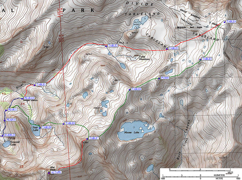
Western portion of my trip, waypoints are at the bottom with a link to an interactive map:
The winter route rejoins the summer trail at about 8.5k (waypoint PEAR05), drops off the ridge into a drainage, then climbs over a hump (waypoint PEAR07) before sidehilling down to Heather Lake. Over the next hump (waypoint PEAR08-09) and down to the drainage below Emerald Lake. Very steep and icy sidehilling (waypoint PEAR10) can be bypassed by dropping closer to Aster Lake, then over the final hump to the Pear Lake Ranger Station (waypoint PEARAN, 350' below Pear Lake in a stand of tall trees) where the Lodgepole rangers had asked me to check in.
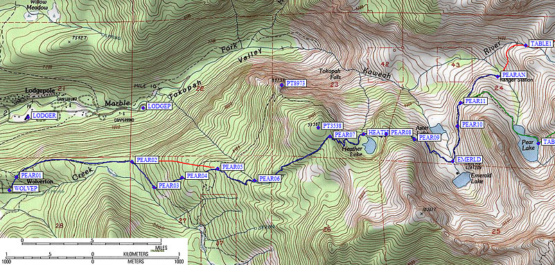
Surprise! The ranger is only on duty 3 days a week, and had just left for the weekend. You know, right before all the people showed up. Odd timing. There is a lottery for permits to stay in the hut, which looks very comfortable. The Kaweah River runs all year, but a few hundred feet above the ranger station (waypoint TABLE1) there were lots of snow bridges across it. Plenty of water without melting snow if you can climb down 5' vertical banks without falling in! Skiers I met below the hut were leaving early because they were having no fun. Snowshoes worked pretty well, especially the MSR Lightning Ascent with lots of metal edge traction on the windslab and icy spots.
Between the ranger hut and Table Meadows was the warmest section of the trip. I stopped for lunch and was actually hot in the sun when the wind wasn't blowing. By 10k the snow cover was solid with no liquid water evident. Stunning spring conditions under a deep blue sky except the snow was crust over sugar rather than corn. I angled up the left side of the valley (under Point 10695) but hit some up-and-down and would have probably made better time staying in the bottom of the drainage. Between waypoints TABLE3 and TABLE4 it seemed like I was trudging across the arctic: appearing flat, but actually undulating which makes efficient navigation tricky. I cheated with a GPS and made good time.
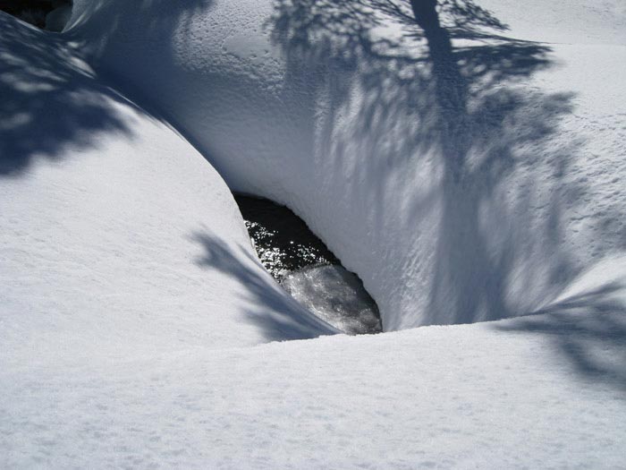
I reached the Kings-Kaweah Divide (waypoint TABLE4 at 11.2k) above Lake 10402 (NW of Big Bird Lake) around 4pm, as the temperature dropped like a rock and the wind picked up. The crust-over-sugar snowpack wasn't stable enough to go down the steep eastern slope with a full pack. Well, actually, going down would have worked OK but coming back up would have been ugly. I looked for some sort of cover from the wind but ridges generally don't have any. I cut chunks of the windslab and built a 3-sided windbreak in under an hour. This is half the time of a good snow cave, there wasn't any blowing spindrift to worry about, and I had a zero-degree bag in a bivy so all I needed was to keep out of the wind for cooking and melting water.
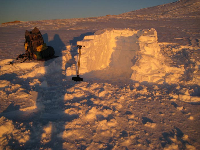
Camping on a ridge has benefits! The Fresno city lights came out as the sun sank, and I could see the earth's shadow turning the eastern sky red and blue at the same time. Camping on a ridge has downsides! The wind blew all night and it was 10F in the morning. My sunscreen froze solid and I had to share my sleeping bag with my water and battery operated equipment. The long views were fantastic, and sunset faded into moonlight and then into sunrise all with the city lights for contrast. Very nice!
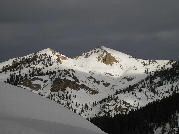
Glacier Ridge had no snow on the top, bands of rock/ice at the bottom, and thin-ish snow in the middle. Not a fun place to be. So I sent a text message with my new plans and headed off the Divide on the "ridge" north of Moose Lake toward Alta Peak. This confused ridge has lots of bumps and side valleys, but is a trivial walk. For a while. It's tempting to skirt the bumps, but easier to just follow the ridge where bare boulders occasionally revealed signs that others have been this way. The bowl down to Moose Lake would be great fun for skiers, but I saw no tracks.
Eastern portion of my trip, waypoints are at the bottom with a link to an interactive map:
Once west of Moose Lake, the ridgeline rises sharply to Point 11328. I left most of my gear (carrying a full 4-day pack until now) at the saddle just east of 11328 (waypoint TABLE7) and did the last mile to Alta with a daypack. It was surprisingly different than the rest of the trip! A knife edge capped by snow, requiring a duck-walk (toes on one side, heels on the other) and no tripping. A bit of 3rd class rock to avoid moats and hollow snow. Several ups and downs, plus some traversing steep and icy enough that I worried about damaging my snowshoes (which had plenty of traction but too much torsion). In between the fun spots there was soft afternoon snow that required snowshoes. I swear I spent half my time switching between boots, crampons, and snowshoes. An ice axe was absolutely required, and held my weight several times.
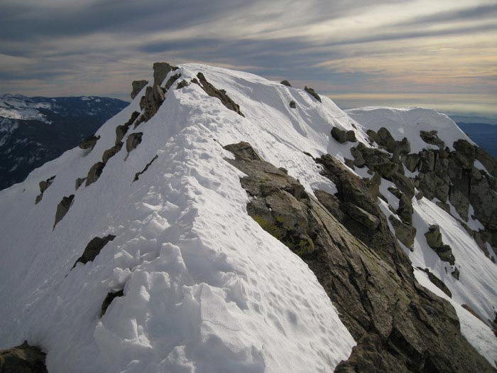
The east ridge to the south side of the summit block is definitely the most fun approach to Alta, with the final 50' requiring hard-kicked steps around schrunds and icy walls. If I had brought my full pack I would have gone back via Panther Gap, but it seemed unreasonably dangerous to take a big pack on that ridge.
Alta Peak (waypoint ALTAPK, 11240') is 100' shorter than the unnamed bump where I left my gear, but it's the one with the name so it's the one with the register. I was not the first one to summit this year. By 2pm it was far from warm due to a high layer of clouds spreading from the south and making the central valley look somewhat like an ocean. I re-traced my steps, packed up all my gear, and plunge-stepped down the north face of Point 11328. As it leveled off I switched to snowshoes and began traversing around the ridge (waypoint TABLE8) toward the east shore of Pear Lake. Dicey there. Lots of frozen waterfalls if you're an ice climber, and steep slopes down to the lake with lots of small cliffs. The east slope above Pear Lake is a pretty place to hang out in the summer.
I found a chute between the rock bands but the flat afternoon light kept me from being sure what was below. Several times I did an extended standing glissade wearing snowshoes! Fun, but not for the faint of heart. The edges of the lake showed some signs of water but I think it was just snowmelt flowing out on top of the ice. At least that's what I told myself as I walked across the lake (from waypoint TABLE9) to avoid cliffs and getting up on the west shore well away from the outlet area. 50 yards below the outlet, the stream was flowing openly.
I traversed down and out of the Pear Lake bowl, camping just before the icy traverse north of Emerald Lake (waypoint PEAR11). I wanted to do the sidehill traverse with crampons in the morning rather than with snowshoes in the afternoon. Another great sunset with city lights (if you pick your campsite properly) was followed by a much warmer night (20F) and fast-moving clouds from the west in the morning. Counting the two bumps on the short hike out, the trip totalled 7200' of gain. I had a few snow flurries on the hike out, and a few rain showers on the drive home, but the real storm hit after I was sitting by a warm fire with my family.
Datum,North America 1983,GRS 80,0,-1.6E-7,0,0,0
RouteName,1 ,PEAR LAKE
RoutePoint,D,WOLVEP, 36.5963499546,-118.7343599796,11/13/2001,02:50:24,WOLVERTON PARKING
RoutePoint,D,PEAR01, 36.5977599621,-118.7334799767,01/06/2007,17:33:04,
RoutePoint,D,PEAR02, 36.5993399620,-118.7184799910,01/06/2007,17:33:04,CAN STAY ON RIDGE IN WINTER
RoutePoint,D,PEAR03, 36.5966600180,-118.7156499624,01/06/2007,17:33:04,MARKED PANTHER-PEAR WINTER JCT
RoutePoint,D,PEAR04, 36.5976899862,-118.7120399475,01/06/2007,17:33:04,WINTER ROUTE LEVELS OUT
RoutePoint,D,PEAR05, 36.5986100435,-118.7074300051,01/06/2007,17:33:04,WINTER ROUTE SAME AS TRAIL
RoutePoint,D,PEAR06, 36.5973800421,-118.7026100159,01/06/2007,17:33:04,
RoutePoint,D,PEAR07, 36.6019699574,-118.6928800344,01/06/2007,17:33:04,HUMP BEFORE HEATHER
RoutePoint,D,HEATHR, 36.6022499800,-118.6885099411,02/11/2011,05:24:03,HEATHER LK 9200
RoutePoint,D,PEAR08, 36.6022200584,-118.6856299639,01/06/2007,17:33:04,HUMP BEFORE EMERALD
RoutePoint,D,PEAR09, 36.6017099619,-118.6820000410,01/06/2007,17:33:04,
RoutePoint,D,EMERLD, 36.5993900299,-118.6770199537,02/11/2011,05:24:24,EMERALD LK 9200
RoutePoint,D,PEAR10, 36.6030700207,-118.6764099598,01/06/2007,17:33:04,STEEP SIDEHILL
RoutePoint,D,PEAR11, 36.6055300236,-118.6759799719,01/06/2007,17:33:04,HUMP BEFORE RANGER
RoutePoint,D,PEARAN, 36.6082600355,-118.6712000370,02/11/2011,05:24:55,PEAR LK RANGER STA 9200
RouteName,2 ,TABLELAND
RoutePoint,D,PEARAN, 36.6082600355,-118.6712000370,02/11/2011,05:24:55,PEAR LK RANGER STA 9200
RoutePoint,D,TABLE1, 36.6115100384,-118.6675800085,01/06/2007,17:33:04,
RoutePoint,D,TABLE2, 36.6208200455,-118.6463099718,02/11/2011,05:26:41,
RoutePoint,D,TABLE3, 36.6201699972,-118.6283400059,02/11/2011,05:27:28,
RoutePoint,D,TABLE4, 36.6266000271,-118.6112200022,03/15/2011,22:02:23,DEADMAN CYN OVERLOOK
RoutePoint,D,TABLE5, 36.6176337004,-118.6184561253,01/06/2007,17:33:04,
RoutePoint,D,P10860, 36.6130900383,-118.6305999756,01/06/2007,17:33:04,
RoutePoint,D,TABLE6, 36.6104199886,-118.6393500566,03/15/2011,22:09:14,
RoutePoint,D,TABLE7, 36.5986698866,-118.6519448757,01/06/2007,17:33:04,
RoutePoint,D,ALTAPK, 36.5905200243,-118.6632900238,09/02/2005,14:31:54,6_1 ALTA PEAK 11240
RoutePoint,D,TABLE7, 36.5986698866,-118.6519448757,01/06/2007,17:33:04,
RoutePoint,D,TABLE8, 36.6022378206,-118.6589999199,03/15/2011,22:13:51,
RoutePoint,D,TABLE9, 36.6012799740,-118.6659599543,03/15/2011,22:14:17,
RoutePoint,D,PEAR11, 36.6055300236,-118.6759799719,01/06/2007,17:33:04,HUMP BEFORE RANGER