|
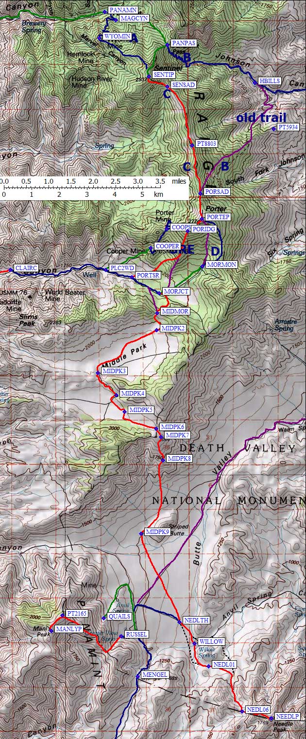
Click for a map of the entire trip. Climbing waypoints are at the bottom. |
See the trailhead page
for driving directions with maps and waypoints. See also my 2012 trip report for a no-snow winter trip. |
|
Freed from weekend warrior schedules, my plan this winter has been to drive or fly to the desert in a storm and climb some peaks as it clears so I'm not there when the next storm hits. So far, it's working brilliantly! This time, in the pouring rain, odd colored water was washing across the roads in Argus and Trona heavily enough to slow traffic to a crawl. At least the normal dust and smells were in remission. I drove on, reaching the turnoff to Ballarat (waypoint BALJCT) during a lull in the storm.
Ballarat has a caretaker and a "store" where I could get cold drinks but no food. The mine south of here on Wingate Road is still active, and semi trailers roar across the "dry" lakebed on a well-groomed dirt road (when it's not under water). Wingate goes south (toward Mengel Pass) but I went east following a hand-painted sign up Pleasant Canyon in my sedan. I know, it's a 4WD road. But with all the snow I figured no vehicle would make it very far anyway. The road up Pleasant Canyon starts off a bit rocky, but OK for passenger cars. Soon the road steepens abruptly and after a 200' climb narrows along a brushy stream. I parked at the bottom of that climb (waypoint PLCN03, 2100') where nice running water sounds were replaced by some lightning and steady rain soon after I got my tent up. It was loud and wet from 5-10pm, with showers all night. I ate comfortably in the tent, read a magazine, and wondered if this time I had pushed my weather luck too far. |
|
I started up the road at 615a, the first walkable light, with only a few puffy clouds and a heavy snow line to remind me of the storm. I had supplies for 5 days, assuming I could melt snow for water. I packed extra stuff assuming no cell phone reception: I'd be on my own if I screwed up, and no one would come looking until next week.
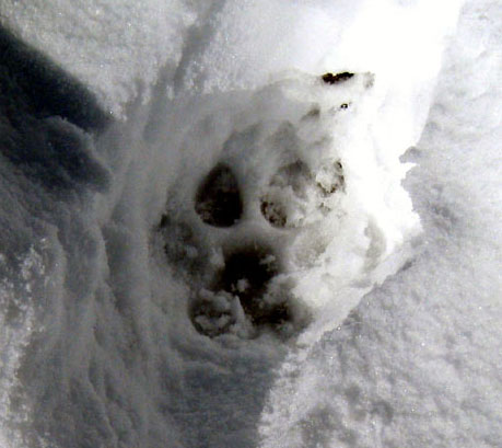
The road was good walking, except where it was a stream, to Claire Camp at 4500' (waypoint CLAIRC) where the continuous snow started. Around 5000' there were some tracks, almost as wide as my size 14 boots, which I couldn't identify. Anyone who's sure what these are, please contact me! [In 2012, just a few miles from here, hikers in Surprise Canyon told me they definitely identified a mountain lion.] |
|
Soon I was wearing snowshoes and wading in powder. Road junctions blurred. At 6200' the old snowed-under 4WD tracks ended and there was 18" of snow on the ground. Realizing the snow was too soft to climb Porter the next day (my original plan), I decided to go for Needle first (instead of waiting for a DPS group which I was supposed to meet there). With no cell phone reception the entire trip, I couldn't change my "flight plan" and I hoped that no one would worry if I wasn't there. I headed toward the 6800' pass south of Mormon Gulch. This pass leads into Middle Park (a big flat valley at 6300') so I'll call it the Middle Mormon Pass (waypoint MIDMOR). Going straight up the road would be hard in the powder, and extra distance, so I angled up and south, reaching the top at 230pm.
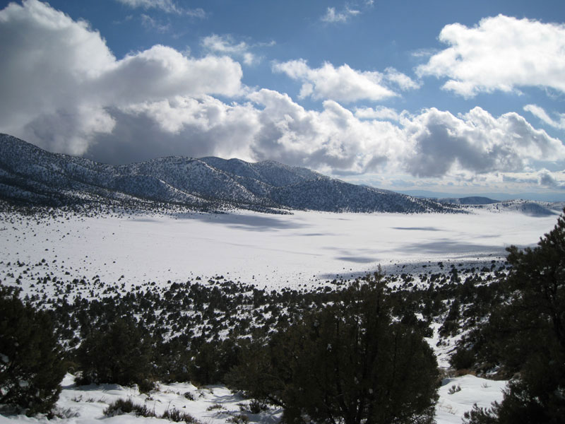
Middle Park from what I'm calling the Middle Mormon Pass.
|
Middle Park was flat and buried in snow. When planning the trip, I had expected to walk this part on a dirt road after climbing Porter and Sentinel in snow. Breakable crust and hot afternoon sun made the going tedious, but I had NPR's Science Friday to keep my mind alive (and a new $20 homemade solar recharger to keep the player alive). I made it over the next pass (waypoint MIDPK3) to the mining camp near South Park (waypoint MIDPK4), tired but with plenty of daylight left: 4850' gain and 11 miles in 10 hours. I set up camp next to a dilapidated steel shack whose walls had radiated enough heat to melt out the only chunk of dirt in the area. I melted 8 quarts of water while the sun set, 2 for camp and 6 to carry down to Needle.
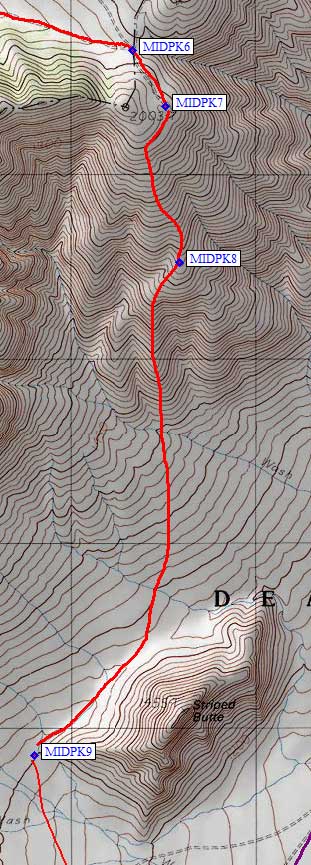
I left camp the next morning at 7am scrunching my toes and wondering if I should have brought warmer boots. It was 15 degrees pre-dawn, the coldest night of the trip, with lots of frost on my bivy bag. The roads in South Park were worse walking than cross country, less consolidated and in the trees, so I just followed a GPS bearing and reached the end of the road (waypoint MIDPK7) at 8am. It's a cool overlook from 6400' down into Butte Valley (the eastern side of Mengel Pass) but I'm unclear on why a road was built to the edge and not down into the valley. Oh, well. Looking down it was not clear which rib was best, but on the way back up I decided I should have walked straight off the edge where the road ends and then aim left of Striped Butte until I could make out the humped ridge (waypoint MIDPK8) which slowly curves right. I made my way down and around to the west side of Striped Butte (waypoint MIDPK9, 4100') where I unpacked my overnight gear. 4 miles and 3 hours from my previous camp I was about to start a dayhike up Needle about 3 miles from the normal trailhead. Walking a straight line to Willow Springs seemed more efficient than climbing up and down on one of several dirt roads. The "squiggle factor" around sparse brush wasn't bad and it was all gentle downhill on stable sandy soil. I intersected a road right at my waypoint for the DPS's Willow Springs trailhead (waypoint NEDLTH), but saw no signs indicating the road was closed there. On the way out I went by the springs and found a nice trailhead at waypoint WILLOW. |
|
In a hurry to reach Needle before the clouds piled up anymore, I crossed the road and bypassed the springs, heading south into the first drainage east of Mengel Pass. I hit a use trail (more likely a burro trail) following the east bank of the wash and then up to a saddle (waypoint NEDL01, 3800') where there are some cool rocks and a small spring. These springs are certainly seasonal, small trickles that run off the talc layer, and may not even be good to drink. This was the only surface water I saw the entire trip except the stream running down the road near my car.
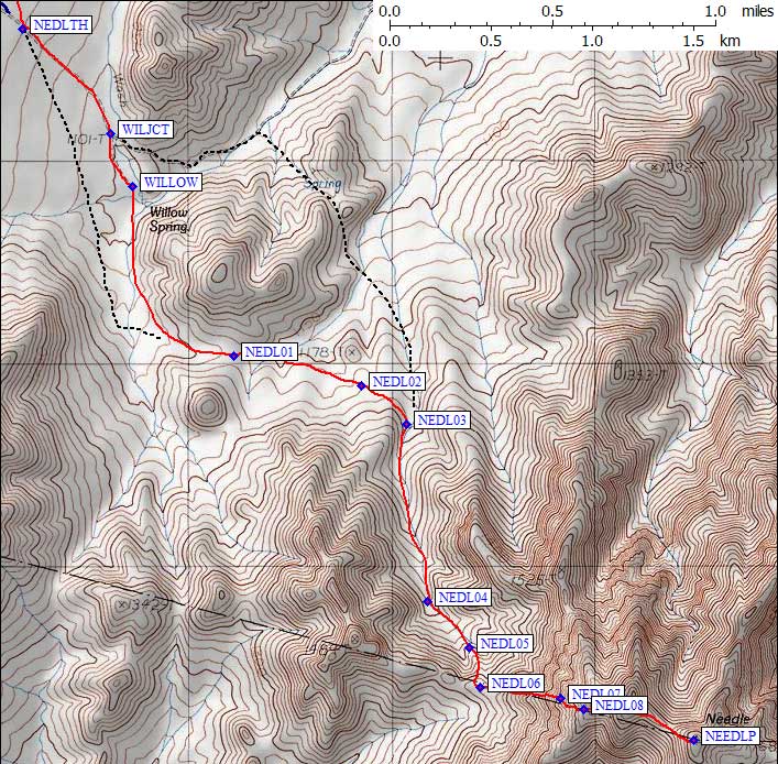
I crossed the streambed east of the cool rocks and held altitude as well as possible from the small saddle, walking downhill only far enough to get around some side gullies and then climbing gradually to a talc outcropping at 3900' (waypoint NEDL02, south of Point 1178). I sidehilled into the next major (south-ascending) drainage (waypoint NEDL03), following the wash to about 4400' where I took a rib (waypoint NEDL05) to the ridge - it's lower angle, better footing, and less words to describe than which gully to take.
I hit the ridge above (east of) the 4600' saddle (waypoint NEDL06), relieved that the intimidating skyline ridge seen from below is BEHIND the ridge I wanted to climb! I couldn't see peak from here, but I followed the ridgeline or stay a bit left up to about 5200', then crossed a knife edge (from left to right at waypoint NEDL07) following some ducks and sidehilled up onto easy slopes and the final summit ridge. There was a red metal Death Valley Border stake on ridge just above where I came up (waypoint NEDL08). Standing at that stake, be sure to look down the route you just climbed and make a mental note about the flake you traversed on the way up - it's easy to start down in the wrong place!
It was 2pm when I reached the top of Needle Peak (5803'), a full hour before my self-imposed turnaround time. For those who wonder whether summit registers need to be weighted down with rocks, take note that this register had been blown away from the cairn and was barely visible under the edge of a melting snowbank. On the summit, like the rest of this trip, I had plenty of cell phone bars, but never managed to connect a single call.
I was back down to the saddle at 315p, and the water bottles I had filled with snow there were melted. Good news, since 6 quarts would have been emergency rations for a day and a half. On the way back to camp, I went to the actual Willow Springs trailhead. According to my GPS, the road ends exactly where the USGS map says it ends, and there is apparently no reason not to drive all the way here if you have a 4WD. There was no "free water" at Willow Springs, just willows growing in damp sand.
From where I camped, there was 2400' of gain on the round trip to Needle (600' of which was coming back to camp), for a total of 2800' gain and 16 miles in 10 hours. This night, at a much lower altitude, the temperature dropped to 25 degrees with the heaviest frost of the trip. It sure was humid (wet sand from the storm) for a desert setting!
I left at 620am, just before dawn, for the backpack back up to South Park. The high clouds of the day before were gone and the clean sunrise was made even better by some good jazz (Max's Boogie), which somehow made all the sights and smells just a little richer. I followed a major burro track along upper edge of Striped Butte, crossing the washes of alluvial fan lower than on the way in for better footing and less up-and-down. It took me 3 hrs to climb from camp back up to the road's end, which is higher than Needle.
South Park was far warmer later in the morning, and I could plod in my old tracks back past the mining camp and back through Middle Park without a pause. A deer had been walking in my tracks, so I guess I did my bit to help the local wildlife. Back to Middle Mormon Pass at noon, I took a long break (after 3100' of gain with a backpack) napping and and spreading out my gear to dry from the morning's frost.
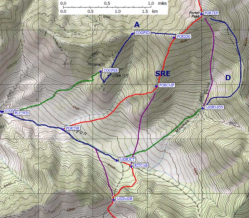
I started north down the road, but it's not as direct as the road on the USGS map, so I soon walked off the edge and made a beeline for the end of the rib at 6400' ... where I stumbled on Rita's Cabin (waypoint RITCAB). The red line on my map is based on Google satellite images which clearly show a road leading down to the waypoint I saved at the cabin. The roof leaks, but there are picnic tables in the yard, dishes on the counter, and it looks like it still gets some use! Someone had tacked up a brief history of the cabin, which is now US Government property (complete with Hantavirus warnings).
It was mid-afternoon when I reached the base of the ridge to Porter, where the snow had melted off in the last 24 hours due to a steep southern exposure. Being tired of breakable crusts and powder, and with the road to the normal Morman Gulch route in a valley full of snow, I chose to climb up rocks and dirt. It went well. The south ridge of Porter (west of Mormon Gulch) would be a good summer route for 4WD-impaired climbers also.
I pushed up the ridge from 6500-7700' going from dirt to rocks and back into snow. It was profoundly quiet here! In Butte Valley there had been birds, burros, and coyotes, here there was just the crunch of my snowshoes and the sound of my breath. I stopped at 430pm, having done 4400' gain and 8 miles in 10 hours, because there were good campsites melted flat (but no dry ground) under south-facing trees (waypoint PORCMP). It was 30 deg overnight, both the highest altitude and the warmest night since leaving my car! My leather boots were completely soaked and froze solid but there was no frost in the morning.
The Amargosa River shines in the morning sun from Porter.
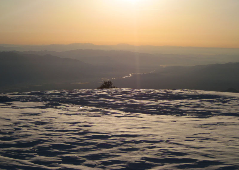
Weaving through the trees up the ridge just before dawn, I hit less steep terrain where two ridges merge (waypoint PORIDG, about 8700'). Here the snow was really powdery and deep so the short distance to Porter Peak's summit (waypoint PORTEP, 9101') seemed to take forever. On top at 730am I briefly worried that Sentinel was too far away - but I was looking at Telescope instead. Whew. I managed to dig the register out of the snow because a steel fencepost marks the summit. The Amargosa River glinted in the morning sun as I pushed down the mighty north face of Porter (a bunny slope, actually) hoping the windslab would continue along the entire ridge.
Nope. No windslab. Mostly breakable crust with powder in the trees. I took a big break at Point 8803, just under halfway between the peaks, leaving there almost 2 hours after I left Porter. Too slow!! But it was getting warmer and the snow conditions improved as the day wore on.
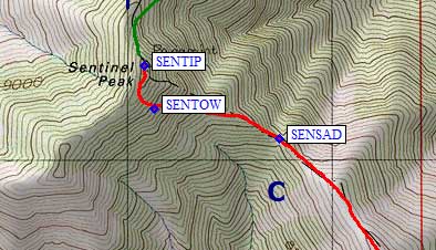
| By the last saddle (waypoint SENSAD, 1000' below Sentinel at 8600') the snow was corning up and not well adhered to a hard lower layer. My new concern was slumps, not powder, so I angled up and left towards white rock towers (waypoint SENTOW, 9300') for better runout and slightly lower-angle slopes. I didn't have an ice axe, but I had MSR Lightning Ascent snowshoes that were better than crampons in these conditions. On the slope, ridgeline actually measured 45 deg and places were over 50 deg. In hard snow this would be serious crampon terrain but on this day I had to kick steps with snowshoes. Very slow going. |
Sentinel summit, with Telescope in the background.
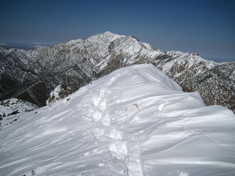
There was a full-on winter snow cap on Sentinel - no rock anywhere near the summit, and the summit ridge was a fractured cornice. I didn't dig for the register or even get too close to the bad edges. I reached the top at 1240pm, 7 hours from camp but with a lot of daylight left and simple navigation with good weather and deep snowshoe tracks even if it got dark. I used my glissade sheet instead of snowshoes going down, rolling out of the track occasionally when too much snow was moving around me. No big movements and I was glad to be back at the saddle quickly.
With tracks to walk in, the return trip proved to be very fast indeed. I was back to Point 8803 about an hour after I left Sentinel, and back to Porter in 3 hrs. The short steps I intentionally made on the way down snow slopes worked beautifully for the return - most of the powder never melted or consolidated but these steps were frozen stairs on the way back. It's more work to leave short steps, but not as much work as making new steps going uphill on the return. I was back in camp just before 5pm, 4600' gain and 10 miles in just over 11 hours.
It got windy during the night, but stayed at 30 deg again. I headed down from camp in extremely breakable crust, soon dropping off the west side to more quickly reach the better snow in the valley under Cooper Mine. The valley was colder than the ridge had been and once the terrain leveled a bit the frozen crust was like walking down a paved trail. Around 6400' the snow got thin and I could tell there would be good dirt footing with easy walking in the summer. I hit the road at 6200' (near waypoint PORTSR), and discovered that serious 4WDs had already gotten this high! There were fresh tracks from the day before. Below Clair Camp I met bikes and Jeeps lumbering up the road.
Wilderness lost. No more profound silence. I stuck the earbuds back in, turned up the volume, and reached the car 3 hours and 5600' down from camp. As if the off-road traffic wasn't bad enough, aggressive gnats were everywhere and the pleasant little brook by my car smelled bad in the warm air. Better to be here when it's cold and/or breezy than when it's warm and calm. The Ballarat caretaker confirmed that gnats are a problem there when it's calm, but I swapped stories and enjoyed a cold beer anyway... before driving home for a Valentine's Day rib dinner with my family.
Epilogue: The DPS trip was cancelled because Mengel Pass has a bad reputation from the west, and the eastern approach from Death Valley was flooded and gated. They thought they had failed to show up for me, and were hoping I didn't end up needing the extra water I had asked them to bring. As for why I didn't climb Manly on this trip, well, Jeff Fisher bounced his 2WD Ford Ranger over Mengel Pass in 1995: We climbed Manly on the way to doing Telescope from below sea level so I didn't bother to climb it again. I just needed Needle, which we didn't even consider back then.
Debbie Bulger adds:
Imagine our surprise when we discovered the footsteps we saw were yours from February 13 as we summited Porter on March 22. We saw two sets of tracks, one descending from the summit. The tracks were melted out, or rather the tracks were intact, and the unconsolidated snow melted around them.
We walked from near Ballarat. (3 days total). We had continuous snow from about 8500 feet. There were ladybugs swarming on exposed rocks at the summit. We "camped" in the cabin at World Beater MIne.
GPS Waypoints
![]() Download the Waypoint+ data below as a GPX file for your GPS.
Download the Waypoint+ data below as a GPX file for your GPS.
Datum,North America 1983,GRS 80,0,-1.6E-7,0,0,0
RouteName,1 ,PLEASANT CANYON
RoutePoint,D,BALTRN, 36.0320770741,-117.2454816103,01/30/2010,19:35:53,
RoutePoint,D,BALRAT, 36.0476940870,-117.2240554094,01/30/2010,19:15:17,BALLARAT RD JCT WINGATE RD
RoutePoint,D,PLCN01, 36.0502077341,-117.2167022228,01/30/2010,19:36:14,RIGHT FORK
RoutePoint,D,PLCN02, 36.0460093021,-117.2099629641,01/30/2010,19:36:27,
RoutePoint,D,PLCN03, 36.0358452797,-117.1902325153,03/23/2010,14:37:07,PASSENGER CAR TH 2100
RoutePoint,D,PLCN04, 36.0328371525,-117.1762946844,01/06/2007,17:33:04,SIDE ROAD
RoutePoint,D,CLAIRC, 36.0332880020,-117.1334123611,01/30/2010,19:35:02,CLAIR CAMP MAYBE GATED 4500
RoutePoint,D,PLCN06, 36.0319266319,-117.1174852848,01/30/2010,19:38:08,
RoutePoint,D,PLCN07, 36.0325999260,-117.1112259626,01/06/2007,17:33:04,
RoutePoint,D,STONEC, 36.0336761475,-117.0970414877,01/06/2007,17:33:04,STONE CORRAL PORTER MINE
RoutePoint,D,PLC2WD, 36.0332719088,-117.0951317549,01/30/2010,19:38:33,PLEASANT CYN 2WD TH 6000
RoutePoint,D,PORTSR, 36.0307914019,-117.0846505165,01/06/2007,17:33:04,XC ROUTE TO PORTER SOUTH RIDGE
RoutePoint,D,MORJCT, 36.0256254673,-117.0736688375,01/30/2010,19:57:55,
RouteName,2 ,MIDDLE PARK
RoutePoint,D,MORJCT, 36.0256254673,-117.0736688375,01/30/2010,19:57:55,
RoutePoint,D,RITCAB, 36.0246335268,-117.0707037449,01/06/2007,17:33:04,RITAS CABIN 6400
RoutePoint,D,MIDMOR, 36.0190774202,-117.0743278265,02/04/2010,02:03:00,MIDDLE MORMON PASS
RoutePoint,D,MIDPK2, 36.0134512186,-117.0745111704,02/04/2010,02:03:13,ROAD DOES NOT MATCH MAP
RoutePoint,D,MIDPK3, 35.9994322062,-117.0981752872,02/04/2010,02:03:30,RIDGE BTWN MIDDLE AND SOUTH PARK
RoutePoint,D,MIDPK4, 35.9922432899,-117.0908885002,02/04/2010,02:03:42,OLD MINING CAMP
RoutePoint,D,MIDPK5, 35.9867731333,-117.0875763893,02/04/2010,02:03:51,LANDING STRIP
RoutePoint,D,MIDPK6, 35.9812459946,-117.0748134851,02/04/2010,02:03:58,SADDLE AND JUNCTION
RoutePoint,D,MIDPK7, 35.9784612656,-117.0728807449,02/04/2010,02:04:13,ROAD ENDS ABOVE BUTTE VALLEY
RoutePoint,D,MIDPK8, 35.9708683491,-117.0720263720,03/24/2010,16:34:50,BEST RIDGE
RoutePoint,D,MIDPK9, 35.9467830658,-117.0807685852,02/04/2010,02:04:54,TOE OF STRIPED BUTTE
RoutePoint,D,NEDLTH, 35.9178512096,-117.0653545856,01/30/2010,21:12:51,DPS NEEDLE BNDY 4WD TH 3700
RoutePoint,D,WILJCT, 35.9132014513,-117.0604852438,01/06/2007,17:33:04,WILLOW SPR JCT
RoutePoint,D,WILLOW, 35.9108488560,-117.0593308210,01/30/2010,21:15:13,WILLOW SPR 4WD TH 3600
RouteName,3 ,NEEDLE PEAK
RoutePoint,D,WILLOW, 35.9108488560,-117.0593308210,01/30/2010,21:15:13,WILLOW SPR 4WD TH 3600
RoutePoint,D,NEDL01, 35.9033139944,-117.0537842512,01/30/2010,21:15:27,SADDLE WITH COOL ROCKS
RoutePoint,D,NEDL02, 35.9020006657,-117.0467685461,01/06/2007,17:33:04,TALC OUTCROPPING 3900
RoutePoint,D,NEDL03, 35.9002885818,-117.0443186760,01/30/2010,21:15:53,DROP INTO WASH
RoutePoint,D,NEDL04, 35.8923908472,-117.0431951284,01/30/2010,21:16:01,
RoutePoint,D,NEDL05, 35.8903540373,-117.0409114361,01/06/2007,17:33:04,BEST FOOTING ON RIB
RoutePoint,D,NEDL06, 35.8886051178,-117.0402790308,01/30/2010,21:16:07,HIT RIDGE ABOVE SADDLE
RoutePoint,D,NEDL07, 35.8881196976,-117.0358799696,01/06/2007,17:33:04,CROSS KNIFE RIDGE
RoutePoint,D,NEDL08, 35.8876422644,-117.0346499681,01/06/2007,17:33:04,RED STAKE ON RIDGE
RoutePoint,D,NEEDLP, 35.8862700462,-117.0285799503,01/26/2008,10:29:40,2_11 NEEDLE PK 5803
RouteName,4 ,PORTER PEAK
RoutePoint,D,PLC2WD, 36.0332719088,-117.0951317549,01/30/2010,19:38:33,PLEASANT CYN 2WD TH 6000
RoutePoint,D,PORTSR, 36.0307914019,-117.0846505165,01/06/2007,17:33:04,XC ROUTE TO PORTER SOUTH RIDGE
RoutePoint,D,PORCMP, 36.0379350185,-117.0656093359,01/06/2007,17:33:04,CAMP ON PORTER SOUTH RIDGE
RoutePoint,D,PORIDG, 36.0460066795,-117.0620501041,01/06/2007,17:33:04,PORTER SW AND S RIDGE
RoutePoint,D,PORTEP, 36.0499000549,-117.0564399958,01/26/2008,10:29:40,2_9 PORTER PK 9101
RoutePoint,D,MORMON, 36.0342764854,-117.0561504364,01/30/2010,19:57:07,MORMON GULCH 4WD TH 7000
RoutePoint,D,MORJCT, 36.0256254673,-117.0736688375,01/30/2010,19:57:55,
RoutePoint,D,PORTSR, 36.0307914019,-117.0846505165,01/06/2007,17:33:04,XC ROUTE TO PORTER SOUTH RIDGE
RoutePoint,D,PLC2WD, 36.0332719088,-117.0951317549,01/30/2010,19:38:33,PLEASANT CYN 2WD TH 6000
RoutePoint,D,COOPER, 36.0403399467,-117.0769200325,01/30/2010,19:39:19,COOPER MINE 4WD TH 7100
RoutePoint,D,COOPSD, 36.0466420650,-117.0704782009,01/30/2010,19:58:06,SADDLE ABOVE COOPER MINE
RoutePoint,D,PORIDG, 36.0460066795,-117.0620501041,01/06/2007,17:33:04,PORTER SW AND S RIDGE
RoutePoint,D,PORTEP, 36.0499000549,-117.0564399958,01/26/2008,10:29:40,2_9 PORTER PK 9101
RouteName,5 ,SENTINEL PEAK
RoutePoint,D,PANPAS, 36.1069999933,-117.0702999830,01/30/2010,20:07:52,PANAMINT PASS 8100
RoutePoint,D,SENTIP, 36.0965299606,-117.0776699781,01/26/2008,10:29:40,2_8 SENTINEL PK 9634
RoutePoint,D,SENTOW, 36.0946295261,-117.0771543980,01/06/2007,17:33:04,WHITE ROCK TOWERS
RoutePoint,D,SENSAD, 36.0932904482,-117.0702991486,03/24/2010,19:11:26,SADDLE S OF SENTINEL
RoutePoint,D,PT8803, 36.0739599466,-117.0603599548,01/30/2010,19:58:54,
RoutePoint,D,PORSAD, 36.0581803322,-117.0569877625,01/30/2010,19:58:34,SADDLE N OF PORTER
RoutePoint,D,PORTEP, 36.0499000549,-117.0564399958,01/26/2008,10:29:40,2_9 PORTER PK 9101
RouteName,6 ,MANLY PEAK
RoutePoint,D,GOLER7, 35.9145200253,-117.0827800035,01/30/2010,20:55:23,
RoutePoint,D,GOLER8, 35.9149813652,-117.0841141939,01/30/2010,20:56:00,
RoutePoint,D,RUSSEL, 35.9131699800,-117.0889500380,01/30/2010,20:56:08,RUSSEL CAMP 4WD TH 4400
RoutePoint,D,MANLY1, 35.9080547094,-117.0949029922,01/30/2010,20:58:48,SADDLE ABOVE TH
RoutePoint,D,MANLY2, 35.9135288000,-117.0986881256,01/30/2010,20:59:06,SHOULDER ABOVE SADDLE
RoutePoint,D,PT2165, 35.9200781584,-117.1125669479,01/30/2010,20:58:22,
RoutePoint,D,MANLYP, 35.9149800539,-117.1169199944,01/26/2008,10:29:40,2_10 MANLY PK 7196
RoutePoint,D,PT2165, 35.9200781584,-117.1125669479,01/30/2010,20:58:22,
RoutePoint,D,MANLY2, 35.9135288000,-117.0986881256,01/30/2010,20:59:06,SHOULDER ABOVE SADDLE
RoutePoint,D,QUAILS, 35.9191000462,-117.0959500074,01/30/2010,21:01:23,QUAIL SPR 4WD TH 4900
RoutePoint,D,QUAIL4, 35.9255499840,-117.0914800167,01/30/2010,21:02:01,HATCHET SPR JCT
RoutePoint,D,QUAIL3, 35.9277399778,-117.0907599926,01/30/2010,21:02:51,
RoutePoint,D,QUAIL2, 35.9301999807,-117.0866500139,01/30/2010,21:02:41,
RoutePoint,D,QUAIL1, 35.9211399555,-117.0841499567,01/30/2010,21:03:04,