Waking up at Bunny Flat on Friday morning, I saw light clouds just as predicted. The air was cold, but not too cold for 7000 feet in April, and there was hardly a breath of wind. Peering up towards the towering white summit, it also appeared to be relatively calm. The forecast was for clearing and warming weather. The sun was rising, so it was time to get up and start packing for the climb. I didn't see the other car yet, but hopefully they would be arriving soon.
You can climb Shasta any month of the year, but most people find it more aesthetic and enjoyable when it's shrouded in snow. Winter makes for a good challenge if you don't mind cold and short days, but spring is more popular because a little more warmth and daylight bolster one's spirit. Tim Hult and I had originally planned this climb for March actually the first weekend of spring. It might have said spring on the calendar, but we were preparing people for what could easily be a full-on winter climb excepting the longer days. After all, Shasta is notorious for its often extreme weather. It's pretty easy to dig up tales of tents shredded and gear blown away. On occasion people even die there. So when the appointed weekend neared and the forecast was for cold temperatures, moderate winds, and a few inches of fresh snow, the decision to call it off came pretty easily. We vowed to reschedule, but I got busy at work and almost forgot about it.
Then in mid April we got our act together. The email went out to those who had signed up in March: can you make it this weekend? Impressively, five of the original eight could make it. Word leaked out and two more joined the crew. This time the forecast was completely different clearing and calm, with temperatures going from average to above average. The route was still the same Sargents Ridge. It's one of at least 4 or 5 routes readily accessible from Bunny Flat. It's not the quickest way to the top, so we budgeted 3 days for our climb.
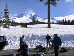
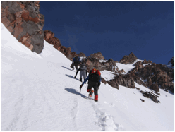
The other car rolled up before 8:00, so we had our full group. (Kelly Maas, Tim Hult, Frank Martin, Julius Gawlas, Mike Snadden, Louise Wholey and Lisa Barboza) Some of us bought the required summit pass, which is available at Bunny Flat. Each person needs their own (free) wilderness permit too. Before too long we were hiking the remaining stretch of unplowed road beyond BF. Fortunately this morning snowmobiles were few. We had debated between snow shoes and skis, but decided on snow shoes. For now, we carried them on our backs. We would stash them at the base of the ridge.
A shortcut can be taken to Sargents Ridge. This is called Green Butte to Sargents, and is more direct from BF, basically forming the right margin of Avalanche Gulch. Casaval Ridge forms the left margin. To do the full Sargents, you follow the road a couple of miles up to Panther Meadow which is all snow this time of year then up into the old ski bowl. From there you can pick up an initially gentle ridge that ascends to join Sargents. We seemed to be detouring away from the summit to pick up this ridge, but it's a continuous and elegant line.
A major landmark at about 11,000 ft on Sargents is Shastarama Point. It has a small bowl sitting just off the NE side of the ridge, and this is where we had planned to camp for both nights. From the ski bowl, Shastarama didn't look very far, but that's deceptive. The initially gentle ridge steepened, and we soon slowed down under the load of our heavy packs.
People warmed up and many stripped down to short sleeves. Most of the way we stayed directly on the ridge, and there was only one stretch that was bare of snow. Once on Sargents, or a bit before, gendarmes pushed us onto the left slope, which dropped into the ski bowl. The snow was a bit soft on top, but there was a harder layer several inches down. (It had snowed about 8 days earlier.)
We finally reached Shastarama around 5:30. The ridge right there flattens out and is wide enough for tents. It seemed like a horribly exposed place if the winds were to pick up, but it also offered tremendous views in almost all directions. The winds were still calm and forecast to remain mild, so Tim and I agreed that we could camp on the crest of the ridge. Even so, we erected the tents in pits, with snow walls which turned out to be unnecessary. In comparison, I had done this route several years ago in May. That time we had dropped a hundred feet from the ridge into the bowl beneath Shastarama, in hopes of escaping the winds. Even so, our tents were nearly flattened. A real reminder that the weather can make all the difference on this mountain.
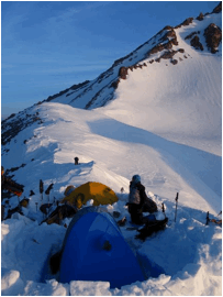
We enjoyed the great camaraderie, food and views, and most of us slept well that night, with temperatures dropping into the teens and the wind remaining calm. Incredible. We turned out to be perfectly positioned, with nothing to block either sunset or sunrise. (Earlier in the year, however, Shastarama might block sunrise.) The clouds had now thinned to just little wisps, and the day looked grand. Tim and I struggled to melt snow and cook with our stove, so we got a late start for the summit 8:15.
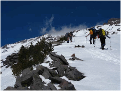
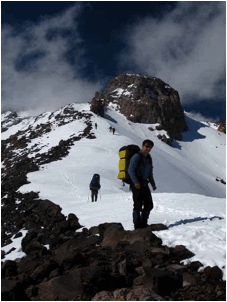
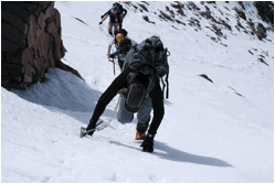
From Shastarama, the Sargents flattens out for a quarter mile before resuming its ascent to the summit, amid a host of rocks and blocks. Most of these obstacles are passed on the left, though we chose to pass the first one on the right because of the straighter line. Snow cover is not complete, so many times we switched between snow and rock. We also switched between traversing snow slopes and following the ridge top proper.
A major event of the day occurred when Mike's camera pouch separated from his hip belt and slid hundreds of feet down toward the old ski bowl. Part way down, we saw the camera separate from the case. There was nothing we could do except to note where they came to rest not easy because they traveled a great distance.
Ascending the ridge, there are plenty of options, so it's unlikely that two people would take exactly the same way up the ridge. At some points we ended up on some rock that was steeper than we would have liked. We decided that we would find an easier way on the return. Eventually the obstacles eased and the remaining bit to Red Banks was straightforward. We had passed the juncture with Green Butte Ridge without really realizing it.
At Red Banks we ran into Monique Messie and her friend Gabriel, who had hiked up with skis that morning from Bunny Flat. They hadn't originally planned to summit, but they had enough energy that they decided to give it a go.
Above Red Banks, the route is much more straight forward. A short ascent brought us to the base of Misery Hill, and time for lunch. It was now well past noon, so we quickly resumed the steady march, despite Mike really feeling the altitude. Looking around, I noticed that the clouds were now completely gone. The temperature was cool, as expected at 13000 ft in April, but we still enjoyed the occasional gentle breeze because the sun was so hot. When the breeze stopped, we got quite warm while on the move.
Before long we surmounted the hill and gazed across the summit plateau at the glistening throne. Louise and Julius were in the lead, and took a direct line for the top. Lisa, Frank and Tim took the usual zig zag way up. Mike and I took up the rear, plodding our way to the top just before 3:00. With sunset not until 7:55, we knew we had enough time left for our return.
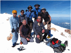
Tim commented that he'd never been on the top when it was so benign. Indeed it was glorious. We snapped our photos and some people signed the summit register. Then we started down. Monique and Gabriel donned their wide AT skis and took off for the trailhead. The rest of us plodded along, but much faster than on the ascent.
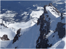
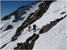
Upper Sargent's Ridge
When we got to the rocky ridge, we decided to stay low on the right and bypass more of the rocks. The snow we descended was often steep and generally soft and crappy, so we went slowly and planted our feet and ice axes with care.
As we approached camp, we slowly began to relax, seeing that we were successfully putting the obstacles behind us. The sun sank lower and shadows began to stretch from the ridge top. Climbing a ridge can be wonderful, if for no other reason than the views.
At the final obstacle, we descended on to steep snow on the NE side of the ridge. We could see camp a short distance away along the nearly level ridge. This side was in shadow, which hopefully meant firm snow instead of the soft and rotten stuff we'd been on. Things had been going so well and everyone had been safe, but then we suddenly saw Lisa cartwheel backwards down the slope. Tim yelled to her to arrest, and after a second flip and a slide, she was able to come safely to a stop using elbows and feet. The slope did have a safe runout, but had she not arrested, she would have built up a lot of speed before reaching more level terrain. We all breathed a sigh of relief and placed our feet and axes more carefully as we covered the couple hundred meters to gentler ground. We reached camp before 6:30 and were soon busy melting snow and cooking. We were impressed at the noticeable melting and/or sublimation that had occurred during the day. Mike calculated that his camera was almost certainly broken or unfindable. We all slept well that night, even though the snow under me was now rock hard and anything but flat. It was a few degrees less cold, and still relatively calm.
The next morning was again beautiful. We hardly wanted to leave, but talk also turned to restaurants and great food. Mike and Julius were soon ready to leave, so they took off in the direction of Mike's camera. They would descend into the ski bowl and join us at the snowshoe cache. The rest of us were soon descending our ascent route, thankful, as we had been the previous afternoon, to have footsteps to follow on the way down.
Midway down, Mike appeared on the next rib over, shouting and waving, with something in his hand. With no wind, we could hear him say that he'd found his camera and that it worked! He and Julius then showed up on our ridge an hour later and we all descended victoriously to our snowshoes. Since Friday, the number of snowmobile tracks in the ski bowl had grown exponentially, but apparently most of it was done on Saturday. This Sunday morning, we only heard a couple of machines. We collected the snowshoes and most people put them on. It's amazing how the road seemed so much longer than on the way up. My pack was becoming increasingly uncomfortable, and I was thankful when we finally reached our cars and the throng of Sunday tourists.
We eagerly packed up and headed into town for a slightly late lunch. Just by chance we stopped at Lilys (http://www.lilysrestaurant.com), where we found good food to satisfy all tastes. We reveled in the glory of a great weekend, and then started the long drive home.
More photos are in albums at