| 
|
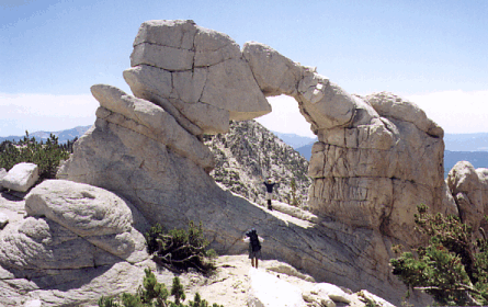
| Arch Rock with McCracken and Prasad in the picture. | Stark area near Arch Rock. |
So the next day we're on Silver Peak and it's about 10:30am... Mike was afraid the group would get back too late at the speed they were moving, and didn't want to split up the group, so he cancelled plans for Sharktooth Peak. I signed out at the summit of Silver, having previously planned to do a solo loop out past Graveyard while Mike's group hiked out.
They went down a northwest chute, while I ran the ridge to the saddle south of Point 11444 hoping to traverse to the saddle northwest of Point 11444... but there were too many trees, so I had to stay near the ridge. I did not see the group after we split, even though I looked for them often. It took just under an hour to traverse from Silver Peak (11878') to Sharktooth Peak (11640'). I topped Sharktooth around 11:30am, where I found a big cairn and no register.
It took half an hour to drop to Sedge Lake (going SE to the first saddle and then angling a bit south to stay mostly in sandy slopes). Sedge is next to Useless! Lake, that is. I finally caught sight of the main group, who had stopped earlier for lunch and were within shouting distance when I saw them! We returned to camp together, around 1pm, then packed up and went our separate ways.
I left Big Margaret Lake around 2pm, following a faint use trail around the north-northeast tip of the lake until it ended at a campsite. From here I started up the ridge, which has fabulous footing (grass and slabs and big trees) and could be used as an approach to Silver Peak also.
|
|
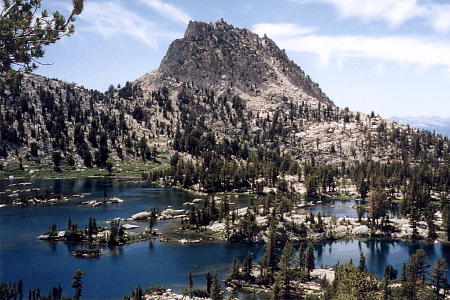
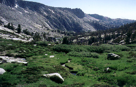
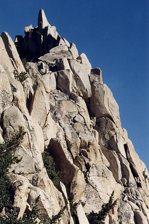
| This Cockscomb, as opposed to the one in Yosemite, is surrounded by lots of lakes and tall wildflowers. | Eventually I drifted off to the south of the ridge (into the drainage that feeds BML). |
This area makes you feel like you're in Yosemite! Big slab cliffs on the south side of the stream, rolling slabs and open grass on the north side, and lush meadows with a meandering stream in between. I took a half hour nap at about 10400 with a gentle breeze, filtered sunlight, and no mosquitos. Spontaneity is one of the joys of travelling solo!
At the head of the valley you can pop over a second class saddle that leads southeast to Devil's Bathtub, or you can pop over a second class saddle that leads northeast to Beetlebug Lake. (I took the latter, having been over the former on my first climb of Silver Peak.) There are man-sized boulders at the bottom and talus at the top, but the rocks are all stable and it's only a few hundred feet up. The pass is second class on both sides.
I left the saddle (which I'd love to call Anne Margaret, except it doesn't lead directly to Anne Lake) at 5pm. You can drop 100' and then traverse some beautiful slabs to the northeast. Even in late July on a low-snow year, there were major snowfields here which had to be crossed: early morning ice could be a problem, but I got a small standing glissade on the soft afternoon corn. I stayed a bit higher (around 10900') than Secor's book suggests, and didn't go to the low point (10800') on the ridge separating Beetlebug and Anne lakes. Instead, I recommend staying high and traversing south to the drainage which feeds Anne Lake. The tundra and tarns there are stunning, and if you head directly to Anne (or any downhill direction) from the 10800' low point, you'll spend time dithering between slabby cliffs that alternate between great walking and 50' drops you have downclimb or go back up to get around.
I stopped for dinner next to the stream in that tundra at 10500'. What a view! From Bloody Mtn in the north to Graveyard Mtn in the east, smooth glacier-polished slabs to sit on, and grass so soft I went to get water in bare feet. Marvelous! During dinner the sun went behind the ridge, but I still packed on to the small lake east of Anne so I could get a good look at the next day's big obstacle: crossing the Silver Divide. It didn't look doable via the low point closest to Graveyard Peak. From far away it had seemed reasonable. From up close it looked like cliffs.
The western saddle of the Silver Divide (between Point 11225 and Graveyard Peak, at 10840+) turns out to be second class on both sides! Lucky me! From the Anne Lake drainage (northwest of the saddle) I climbed a talus fan just left of the light slabs which are in turn left of the dark slabs that form the low point. The fan curves left and becomes a ramp with some grass. Just before the ramp ends in a headwall, there is a defect leading up to the right: Where the light and dark rocks meet, you can traverse to the low point with a full pack and no hands. It feels a bit like cheating, given how intimidating the slabs look from below.
On the Graveyard Lakes (southeast) side of the saddle, the cliffs steepen as you go down, and I could never see a continuous route directly down from the saddle. Rather than risking a dead end (before the Graveyard) I traversed east and dropped slowly to the lake at 10360-, on mixed grass and boulders, following the area which the map shows as slightly lower angle. It works, all 2nd class.
I climbed Graveyard Peak from that 10840+ Silver Divide saddle, having read in Secor's book that the northeast ridge was "easy class 3." Well, it's not easy, and it's not class 3, at least not if you stay on the ridge proper. It starts off nice enough, then goes to 5'-wide class 2, then to exposed class 3 where you have one foot on each side of the ridge at 11000', and then eases off a bit but remains 3rd class until the final insult: There is a black tower on the ridge which I would not attempt without a rope. Going around the tower at 11300' and regaining the ridge I could see the route to the summit was NOT class 3. Perhaps there is a trick I didn't see, but I was solo and I bailed off the ridge at 11400'.
|
I went across the east face, climbed up to the apparent low spot
on the summit ridge, got out my map and GPS, and had a long hard
look at the ridge. Don't let those long smooth topo lines fool
you, the summit ridge isn't smooth. It's made up of large blocks
which I could not work my way around without taking excessive risks.
The route up to Graveyard Peak's spire is in the shadow directly in
front of the summit spire when viewed from summit ridge low point.
Thank goodness I had found Roger Crawley's 1992 trip report where he mentioned crossing Graveyard's summit ridge between the high point (right where the NW and NE ridges meet) and the benchmark (to the south). You can see the summit pinnacle from that pass (about 11500'), and the summit is just over 100 yards away according to my GPS, but it took me half an hour to actually GET there! |
|
From the summit ridge pass, you can drop 100' elevation (or more) onto the WEST face, then traverse to directly under the peak and climb straight up to the top. If you do it right, only the last 20-30' to the summit block is class 3 (all the way from the any of the lakes I mentioned). I did some hunting around, and having now been on ALL sides of the summit block, including the top, the only summit block route that's 3rd class is on the west side. The summit itself is less than a foot wide, and a gusty wind was knocking me around, so I didn't actually stand up on it.
I didn't stay long either, as it was cold and smoke from a forest fire in Sequoia was starting to obscure even the local peaks. I just reversed my route, and headed back to my pack. As I went back across the top of the west face, I noted an apparent 2nd class route up a long gully rising from the Devil's Bathtub drainage directly to the low spot on the summit ridge.
Fortunately, on the way up, I had noticed a ramp leading down toward the headwaters of Graveyard Lakes from almost exactly 11000' on the NE ridge (just below the exposed class 3 mentioned above). The ramp leads 100' down to a prominent collection of huge black boulders. From the boulders you can easily drop to the lakes, or traverse the east face of Graveyard on easy sand and granite. On my way down, I traversed the face down to the top of the black boulders, then used this ramp to regain the ridge since my pack was at the saddle and I couldn't just stroll down to Graveyard Lakes. If I had known the route, I would have brought my pack to this ramp on the way up!
The trail down from Graveyard Lakes shows up just where the map says it will, gradually getting larger and easier to follow as you drop down toward Graveyard Meadow. Then it's mostly dust and flies as you trudge down the trail to a warm slice of pie a la mode at Vermillion Valley Resort.